Novemeber 13, 2015.
Someone hit this ancient ride report.
I reviewed it, and like most, it was horribly written.
The writing was moronic.
I am going to attempt to upgrade this to at least the most recent idiotic standards.
They, the two rides to Fort Adams were pure history hunts. I consider them
"classic" among my collection and the research wasn't bad either.
Too bad the writing was so childish.
Let's see if I can give it some help.
I'll even enlarge the pictures a little.
These are the pictures from the original Fort Adams ride. I
returned after their loss. I came from my home near Breaux Bridge which
is to the west so I was not able to show you the original approach from
the east and Mississippi.
Though this is the first ride, it is now a supplement to the
Though this is the first ride, it is now a supplement to the
second replacement Fort Adams visit.
My base of operations for this one was in the Folsom, La. area.
I rode up La.450 from La.25. and then turned west on La.38. All these
roads are {were} covered in "Two Wheelin' Louisiana Magazine".
Let's get going, enough orientation.
Let's get going, enough orientation.
The Lost First FortAdams Ride
Steve's Pond, Somewherealongtheway, Louisiana

Every road is visually layered. You see stuff and you don't see
stuff. I had not seen this place before and I've passed here many times.
In fact, I did a whole write on La.38 and missed it. It's right on the
road. Maybe it wasn't built on my last pass?


Below is a barn Yes, but notice the red painted border.
Don't bulls like red?

Below, is another barn or possible garage, same property. The curled
tin on both buildings are the result of Hurricane Katrina.
Katrina disrupted everything. If it did not destroy history, it hastened its
Katrina disrupted everything. If it did not destroy history, it hastened its
destruction, erasing that past as part of the future.

A Short Rant.
There are some people out there that think this website is held to
historic exactness and that all my statements are fact. They
are......jackasses. I'm a guy who just shares his rides and gives his
observations. My mistake is I assume that most people "get it". The
historical parts are as close to exact as history is. History is
subjective. That said, then my interpretations of what I see are as
good as anyone's.
I have erased the Mz Panhead rant.
People like her meet their own.
I have erased the Mz Panhead rant.
People like her meet their own.
I think the picture below was an old store. It was also on the
property which leads me to believe it was operated by the owner.

Page 2
I ended up in Amite.
Amite is a busy hub and not for one who enjoys the open road. It is a great little town to visit on the
weekend. The City of New Orleans comes through twice a day. Go down to the station and wave to Arlo.
Oops, back to the ride. I needed to go north. My usual route was closed due to a bridge being out.
Yes, it was out and I found out the hard way by doubting the sign once again.
My alternative was McElveen.
McElveen is Scottish. This area was settled by those from Scotland.
So that's where I've seen this house before. The roof damage is from Katrina. Steve's Creek is seen below.
Evidently, McElveen had changed to either Ivey or Hamp Lea Road.
I'd say the Scottish influence was still evident.
Evidently, McElveen had changed to either Ivey or Hamp Lea Road.
I'd say the Scottish influence was still evident.
I was headed to Osyka again. Osyka is the Old South or its remnants.


Lost Home

The back road into Osyka

Steve's Creek

Page 3 ..
Osyka Northwest

Two or three (many and they keep happening) rides have pictures of Osyka in them.
This one won't. I went through town and then west on MS.524. That number might be wrong.
Having enough of pavement, I ended up on the road above, still moving northwest.
Oh, why?
The original mission was to pick up OLD MISSISSIPPI HWY 24.
This was the third portion of that search.
The last segment had ended west of Columbia.
The Liberty area contained portions of the old road.

Old houses require constant work. Don't they all.
I was in the hills now.
The land rises between US 51 and US 61.
The houses and the barns get smaller reflecting life on a "less grand" scale.

Mississippi is sprinkled with these fine old forest churches.


This is the Muddy Springs Methodist Church. The door was locked. I usually find them open.
The picture below was almost discarded until I saw what it symbolized.
I don't usually don't share my interpretations of pictures. Stop laughing.

This one I will. Ok, here goes,
"The road of local life travels through the churches. It is a part of the environment as much as the pines".
The picture was not planned. It is a reflection on several levels.
Below is what we all wish for, a smiley honea.
Cuz when you have a smiley honea, you be smiley, too.

Page 4
Before Liberty, I popped out on new MS.24. I soon saw Old Hwy 24 and took a dip down that first leg.
It was now gravel, or maybe, it had always been gravel. Revelations do come from time to time.
This was April, cool and Spring-E. There wasn't much to see down it.
The next exit of Old 24 was a bit more interesting. Even though I'd been bitten by the last "Bridge Out" sign,
this one proved false. I still don't trust the signs and never will. This one fine home ruled the road.
The "Bridge Out" signs have many uses. They may keep traffic down and privacy up.

Gorgeous

Old 24 led me into Liberty.


Little did I know that I was coming into Liberty very close to an railroad right of way.
Years later I would be back with the purpose of finding that railroad.
Page 5
There is a lot to see in Liberty. The Confederate monument stands out as the most important.
It is north of Highway 24, the main street of Liberty.
Don't miss it. More of Liberty is shown in the other rides.
It is north of Highway 24, the main street of Liberty.
Don't miss it. More of Liberty is shown in the other rides.


Recognize that flag? Probably not.
That is a shame.
It is a sin.
Blame your teachers.
Blame the liberals, blame the Democrats, blame the Progressives and the Politically Correct dictators.

Page6
North, Out of Liberty towards Cole on Old 24-Compromise Road

Below are pictures taken immediately outside of Liberty and headed northwest through what would skirt the
Homochitto National Forest.
Old 24 is a great adventure road. I ended up in Cole on MS.33, west of the Homochitto Forest.
Look closely at the map below.
You can see "Old 24 Compromise" arching above straight MS 24.
Straight 24 is where the Terminator lurks. Do not speed or Trooper Butch Haircut
will be very stern. I know he was a Drill Sargent.
will be very stern. I know he was a Drill Sargent.

Below are pictures taken immediately outside of Liberty and headed northwest through what would skirt the
Homochitto National Forest.
Old 24 is a great adventure road. I ended up in Cole on MS.33, west of the Homochitto Forest.

I believe that there was an older Old 24.
That old bridge might have been for a rail crossing?
I should have inspected it closer.


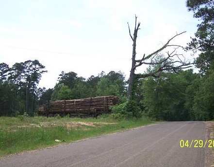
Below is a lumber truck. I must have been hurting for a picture.
Possibly the standing dead tree next to the lumber truck struck a cord.
Punny, huh?
I stopped and soaked in the vision of the bathtub in the field.

Page 7
Here was the town of Busy Corner, Old 24-Compromise Road
Busy Corner had been bypassed by new MS 24 and was not busy anymore.


Page 8
Liberty to Cole, Continued.
What I needed was a good place to eat. Cemeteries are great eateries.


There are usually shaded places around a cemetery and the company is good, always well mannered and
quiet, mostly. I have heard some howling. I write this off as husbands and wives being buried too closely to
one another. There have been some hot breezes that could have only come from that arrangement.
The fella below (pun) was born in 1786. I cleaned the red ant bed off his stone.
An ant bed is all it takes to make history, and you, disappear.
Put your stone high, just a thought. I wonder if he had met Jean LaFitte and Andrew Jackson?
I'll bet he did.
1812 Vet graves can be found everywhere in South Mississippi.
There are even those from the War of Independence.

Some just knock you down.


The importance of service to country is seen from graveyard to graveyard.

What happened to us? Never doubt The War's present importance. The 7th's history is covered on this site.
These new stones are seen everywhere.
Never doubt these Sons of Rebel Sons who are supplying these monuments.

Various versions of Confederate Flags are commonly seen in these backwoods cemeteries.
Lunch with the Hoff-Roberts over, I rode toward Cole, located near the crest of the Homochitto upland.

Page 9
I took Miss Hwy 563.
I came out of the woods at Cole and went north on MS 33 to Crosby.
Right before town I crossed this pretty little stream which offered up evidence of a previous bridge.
See the pilings?
Update below.

I would later find out that the pilings were for a railroad trestle of the Illinois Central RR.
This was the jail.

North of town, MS 563 heads east. It is an enjoyable road.
"Enjoyable" is motorcycle code.


563 ends dramatically at US 61, known as Highway 61 in Mississippi,
the "Blues Hwy" among blues patrons.
I went south through Woodville on this, a Friday afternoon. It was a bee's nest.
It is the county seat and business was ending for the work week.
I've been there on a Sunday and you'd think that it was a ghost town.
West of Woodville, to Fort Adams on Hwy 24, is endless.
It is 17 miles of not much.

The next replacement article covers Fort Adams, so I won't here. It will immediately follow this one.
The old store is the center of the seemingly closed community.

I did not feel welcomed on the first or the second visit. The third won't happen.
Might just be me. Probably.
Below is some of the prevailing architecture not shown in the other write.
Some people were friendly and directed me on how to leave for Pond.
I might ponder that.Other requested directions were very vague.

Page 9a
The short 3 mile road UP to Pond is pretty cool. Originally, I'd come down it.

Erosion is everywhere. Green threatens to swallow you at every turn.
Louisiana and Mississippi, on this latitude, could be considered tropical jungle featuring oaks.

Pond is next up. It is just beautiful.

There could not be a more placid, agrarian setting. The Pond Store is the centerpiece.
Not opened on Mondays. The animal heads inside are fake.

The ducks are real.

Continue reading. We'll return to Pond.
I headed south to La.66

Page 9aa
Reaching LA 66, I turned east. West would have put me shortly at Angola Prison. On the way back to US 61, I noticed this marker.
"Colonial" is the adjective that stands out, as most local old homes use "antebellum" as their dating adjective.
"Colonial" is the adjective that stands out, as most local old homes use "antebellum" as their dating adjective.

There is Old and then there is Real Old. I was in Real Old. That realization does dwarf one's relevance.
History is the Universe of Time. It is unlimited and will repeat itself is caution is not taken.
The future, on the other hand, gets only personal attention by most.
Oops, probably spoiled the pictures. Indeed, Tunica is a beautiful place.


The Replacement Ride will follow.
Here is the replacement for the Lost Second Half of the Last Ride into Mississippi.
As you all remember I lost my computer after posting the first ride to Fort Adams. It had two parts.
The Adams part was lost. That would not do. Unfinished business is the worst form of frustration and it ate
at me. The only remedy was to mount the bike, this time the little hustler DL650.
Mississippi is not that far away.
I like getting there by way of Morganza and New Roads. Sorry, no maps on this one as I don't have a
computer. This is being done on a borrowed one. Anyway, you are all computer junkies and know how to
look up maps. Coming up La. 81 from Lottie, on US 190, and then hitting La.77 into Morganza, I chose a
road from the GPS screen to check out.
PICTURES Below. Though not in its original location, I think I found the Morganza or New Roads rail
station or probably the freight building. Morganza is on the main line down from Alexandria on the way to
New Roads. There is no station on the tracks in town and I think this farmer nabbed it. The pillars are new.
The classic double garage (pictured below) sat down the way. Nice pipe.
station or probably the freight building. Morganza is on the main line down from Alexandria on the way to
New Roads. There is no station on the tracks in town and I think this farmer nabbed it. The pillars are new.
The classic double garage (pictured below) sat down the way. Nice pipe.
The freight warehouse just south of Morganza.

You take their picture from time to time to keep them happy.
Machines will rule. Probably soon.
Best get a good relationship going.

Wheat south of Morganza.

Double garage, mentioned above, near the old freight warehouse.

Page 2
I crossed the Mississippi on the soon to be lost New Roads to St.Francisville monument.
There are few ferries left in Louisiana and you should take advantage of them while you can.
Children love it and they remember.
In fact, I saw a grandpa showing his six year old grandson the sights from the rail as we crossed.
That was cool. As they passed the youngster looked at the bike and asked his grandfather what it was.
The wise man replied, "a big one".
Though not entirely correct, the bike does appear larger with all the junk I carry.
This is the hot South at its finest and you need to get in the Southern groove and take it in.
Let your imagination bloom. This countryside has been the stage for so many layers of history.
As you leave the ferry and go up the hill towards St.Francisville, take the second left, Tunica Road.
Let your imagination bloom. This countryside has been the stage for so many layers of history.
As you leave the ferry and go up the hill towards St.Francisville, take the second left, Tunica Road.
The first thing you will see is an old cabin.
By the way, an old railroad right of way is between the road and the river.
I wonder if it goes back to the Bayou Sara days.
We'll touch on that on the way back from where we are going.
Traveling here always nets two rides on the ferry.
That's a big plus.
If I forget to tell ya, Ray, I saw the guy you haggled with in the ferry picture.
If he's lost some weight, it wasn't much.
We'll touch on that on the way back from where we are going.
Traveling here always nets two rides on the ferry.
That's a big plus.
If I forget to tell ya, Ray, I saw the guy you haggled with in the ferry picture.
If he's lost some weight, it wasn't much.
The road goes, just follow it. You are in La., not North Carolina or Arkansas.
If you've been to those places, this place will take you back. It is hidden, lush La. and has become more
hidden since my last trip. That I'll explain later.
If you've been to those places, this place will take you back. It is hidden, lush La. and has become more
hidden since my last trip. That I'll explain later.
This was a Monday and there was no one on this road.
No one? Why? Except this lone bicyclist. She even said, "Hi".
No one? Why? Except this lone bicyclist. She even said, "Hi".
At the low water crossing something had happened.
The remains of the concrete "bridge" lay about.
It had been so neat to cross the river on it.
I guess it had been undermined making it unsafe.
If I had brought a folding chair the ride could have ended here.
The remains of the concrete "bridge" lay about.
It had been so neat to cross the river on it.
I guess it had been undermined making it unsafe.
If I had brought a folding chair the ride could have ended here.
I backtracked looking for a way around the blocked crossing going north.
A glimpse was all I could get of this one.
A glimpse was all I could get of this one.
I guess the sign was right. In LA, often the Police Juries lose or forget their signs.
They stay up forever. You can't trust them. Often, one of the good ol' boys who is in with the Police Jury
just puts a sign up to keep the traffic down. Look up "*Police Jury*".
Sounds scary, huh? You should witness one of their meetings. Comedies can be scary.
That form of government may be part of the *Napoleonic Code*.
In it, all of the politicians pretend to be Napoleon.
Crossing on the New Roads/ St.Francisville Ferry (RIP)They stay up forever. You can't trust them. Often, one of the good ol' boys who is in with the Police Jury
just puts a sign up to keep the traffic down. Look up "*Police Jury*".
Sounds scary, huh? You should witness one of their meetings. Comedies can be scary.
That form of government may be part of the *Napoleonic Code*.
In it, all of the politicians pretend to be Napoleon.

Tunica cabin (Bayou Sara era?)

Tuinica road.

Tunica creek.

Tunica bridge.

Traffic

Sand and rock bottomed stream, later identified as Bayou Sara.

Green, all shades.

The bridge was out.

The Guzzi mirrors were on the DL. I must have already had my spill down south of Delcambre.

Page 3
The area I was in is bordered on the south by La.10 and on the east by the Mississippi River and on the
north by La.66, which all say should be Highway 666 since it leads to Angola Prison. On the east, this area
is bordered by the one and only one, Highway 61. This is Tunica.
north by La.66, which all say should be Highway 666 since it leads to Angola Prison. On the east, this area
is bordered by the one and only one, Highway 61. This is Tunica.
I popped onto Highway 61, yes, "The Blues Highway" and if a 60's kid, even now in your 60's, you
see that US 61 sign and think of this song if ever exposed to Bob Dylan.
Bob Dylan's "Highway 61" is best preformed by Johnny Winter . I can attest to that.
I hate it when people speak of something that I am not privileged to know and offer no explanation.
If you don't know the words to the song that B.Dylan wrote, here they are.
Dylan may be an "acquired taste". I'll grant that.
Hwy 61
Oh God said to Abraham, "Kill me a son"
Abe says, "Man, you must be puttin' me on"
God say, "No."
Abe say, "What?"
God say,
"You can do what you want Abe, but the next time you see me comin' you better run".
Well Abe says, "Where do you want this killin' done?"
God say, "No."
Abe say, "What?"
God say,
"You can do what you want Abe, but the next time you see me comin' you better run".
Well Abe says, "Where do you want this killin' done?"
God says, "Out on Highway 61."
Well Georgia Sam he had a bloody nose.
Welfare Department they wouldn't give him no clothes.
He asked poor Howard where can I go.
Howard said there's only one place I know.
Sam said tell me quick man I got to run.
Ol' Howard just pointed with his gun.
And said that way,
Welfare Department they wouldn't give him no clothes.
He asked poor Howard where can I go.
Howard said there's only one place I know.
Sam said tell me quick man I got to run.
Ol' Howard just pointed with his gun.
And said that way,
down on Highway 61.
Well Mack the Finger said to Louie the King
I got forty red white and blue shoe strings
And a thousand telephones that don't ring
Do you know where I can get rid of these things
And Louie the King said let me think for a minute son
And he said yes I think it can be easily done
Just take everything down to Highway 61.
I got forty red white and blue shoe strings
And a thousand telephones that don't ring
Do you know where I can get rid of these things
And Louie the King said let me think for a minute son
And he said yes I think it can be easily done
Just take everything down to Highway 61.
Now the fifth daughter on the twelfth night told the first father that things weren't right.
My complexion she said is much too white.
He said come here and step into the light he says hmm you're right
Let me tell the second mother this has been done.
But the second mother was with the seventh son
And they were both out on Highway 61.
My complexion she said is much too white.
He said come here and step into the light he says hmm you're right
Let me tell the second mother this has been done.
But the second mother was with the seventh son
And they were both out on Highway 61.
Now the rovin' gambler he was very bored
He was tryin' to create a next world war
He found a promoter who nearly fell off the floor
He said I never engaged in this kind of thing before
But yes I think it can be very easily done
We'll just put some bleachers out in the sun
And have it on Highway 61.
He was tryin' to create a next world war
He found a promoter who nearly fell off the floor
He said I never engaged in this kind of thing before
But yes I think it can be very easily done
We'll just put some bleachers out in the sun
And have it on Highway 61.
Interpret the song as you may or do a search for interpretations by others.
I liked the fact that you could dance to it.
Here's one: Click Here
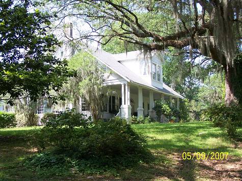
I stopped at the Myrtles (No, it's not named for a Yankee telephone operator).I hadn't been there and only knew of its touristy ghost stories.
The place was gorgeous.
I think it might also be a restaurant (it is) as it was noon and the parking lot was full.
Eating, and then drinking all this in, quite a meal.
Look up "General David Bradford and the Whiskey Rebellion".
Check out the "The Myrtles" site, The Whiskey Rebellion according to Wiki,
and from a thesis, now gone on the Whiskey Rebellion:
"Some people today feel that David Bradford (with his opulent Washington, Pennsylvania house), after being
blackmailed and forced to get involved in the dispute, may have gotten somewhat carried away with dissent.
If it were not for Bradford and the other dissenters, helping to bring the state's right's democracy issue to the
attention of the easterners and lending support to Jefferson's position, the government of today might be the
aristocratic monarchy that Hamilton and the Federalists tried so hard to install. Thankfully, the rebellion
failed, almost before it began. It did publicize some of the problems the settlers were having with the
government, gave the newly formed government a chance to flex its muscles and, in a sense, redefined the
word treason to permit disagreement with the government without being considered treasonous"
These oaks do tell tales.
A friend's daughter is marrying the son of the people who own the place. Do tell.


Next, I would turn off of Highway 61 onto La.66 for a short ride and then turn south back into the
box to explore what was north of the closed river crossing.


Soon after leaving Highway 61, you come upon this bridge that crosses over a river.
It may be the same river that washed out the low water crossing further south.
There's a bridge across the Canadian River in West Texas that is very long and uses the same design but in a
long series. I also liked the red paint. These east Louisiana streams are "something pretty". Now you know
where that dancing Jackson kid got his nickname (pic below).
You knew there was a historical link, didn't you. I wonder? And ghosts of old communities?
I saw the road and figured it didn't go anywhere and it was a little early in the day for gravel.
Gravel requires a warming up period.
I'd only gone 90 miles and wasn't quite warmed up yet.
I don't really believe there is a Plettenburg Post Office or a Plettenburng, anymore.
It was a town on the railroad at one time.
I think it was named after a German town, the railroad's owner's country of origin.
There is a Greenwood. It is magnificent.
The ride to Greenwood will be linked at the end of this ride.
I emerged back out on La.66 and turned toward Angola.
The old store sat on a hill above the road.


That dancing fella's nickname?

Little would I know it, but Plettenburg would become important in my rail history hunts.


Greenwood is pictured in another write.

Page 5
The pages up to now covered incidental stuff I noticed along the way here.
From here on out, I was in the area where I needed to recover from the lost computer disaster.
Ray Fagan had brought Oliver Pollock into focus. Here, on the hilly stretch between Woodville and the
La.state line, this small stone marks Pollock's grave.
He was a national hero, a true patriot in the Revolutionary War. Yet, he lies there passed by.
At least Mississippi has paid him some due.
Here comes more links. Please read them.
This guy was the real deal when it came to diplomacy, hard work and determination to the point of ruining
himself financially. The grave stone doesn't begin to tell it all.
Oliver Pollock and the Revolution, the $ sign, Oliver Pollock's Time Line.
Look, these sites disappear.
The info is too valuable to lose, so, I'm copying it.
Spanish support of the Americans in West Florida against the British was led by Don Bernardo de Gálvez, the Spanish governor of Louisiana. De Gálvez became acting governor of Louisiana on January 1, 1777, replacing Luis de Unzaga de
Amézaga. He was appointed to the post by his uncle José de Gálvez, who was the Spanish minister to the Indies. Soon after taking office, de Gálvez offered his services to the American cause to Oliver Pollock, acting American agent in New Orleans. Oliver Pollock had first come America from Ireland in 1760, landing in Philadelphia. He became a merchant in 1762, basing his operations in Havana. While there, Pollock became a friend of Alejandro O'Reilly, who in 1769 would become governor of Louisiana. In 1768, Pollock moved his operation to New Orleans. When the Revolutionary War began, he had decided to aid the American cause and had enlisted the reluctant help of Governor Unzaga in 1776 in his efforts to acquire supplies for the colonists. For the next two years, Pollock coordinated efforts between Gálvez and George Rogers Clark to keep the American cause armed and supplied through smuggled supplies up the Mississippi River. During this time, Gálvez kept up the appearance of neutrality to the British by making occasional showy prearranged arrests of American smugglers, but he raised British ire by seizing British ships that were engaged in similar smuggling activities. Neutrality fell away when Spain declared war on England on June 21, 1779, and entered into a treaty with France. Gálvez had already begun making preparations for war before the formal declaration was made. Even after he received official word almost two months later, he made no formal
announcement. Instead, he described his preparations as being purely defensive. The first objective was to gain complete control of the Mississippi River, but before Gálvez could launch his offensive, a hurricane struck New Orleans, scattering several of his ships and leaving the city vulnerable to British attack. He took some time to reorganize his defenses and finally on August 27, 1779, Gálvez set out on foot for Fort Manchac with a company of 667 men, while a handful of ships moved up the Mississippi River. Gálvez was joined on his campaign by Oliver
Pollock, who was now an official agent of Virginia and the Continental Congress. Pollock served as his aid. Only when Gálvez was in sight of Manchac on September 6, did he inform his men of the declaration of war. The next day , he launched a surprise attack on Fort Bute which met little resistance, because the British had grown suspicious of Gálvez' activities and already withdrawn their main force to Baton Rouge. Gálvez immediately moved north to Baton Rouge. He spent several days reconnoitering and planning an attack on the well-fortified British position. Finally, on the night of September 20, Gálvez erected a battery and began exchanging artillery with the British. It was a diversionary tactic, while Gálvez had his men erecting another battery within range of the fort. The British were so preoccupied with the other battery, that they never noticed and so it was built quickly and without the men coming under fire. The next day on September 21, 1779, Gálvez attacked and captured Baton Rouge.
As a provision of surrender,
Fort Panmure at Natchez had to be included. Fort Panmure was peacefully surrendered to Spanish Captain Juan Delavillebeuvre on October 5, 1779, by the stunned British commander, who had no prior warning before the Spanish captain's arrival. Now that the Mississippi River had been secured, Gálvez could turn his attentions to Mobile and Pensacola, which was his true goal. Pollock and the Dollar Sign April 1, 1778, Oliver Pollock, a New Orleans businessman, creates "$" symbol.


Next up the Pinchneyville Road was Dessert Plantation.
I stuck my head in the gate and looked around. I was uneasy as there was a gate and no
welcome sign. I would return to explore one of the most beautiful landscapes I have ever seen,
and I've seen a few. This place was ghostly beautiful. It was something you would think impossible to exist in this plastic, billboard littered world.
More later in this write.
Across the road was Mississippi humor at its finest. The little house was named "Oasis" by its
owner. Very funny. Humor was thick on this road as I would see soon. The Old Pond Store was
next. I can't find a Pond Store internet site? I am guessing those two neat cabins are camps or
B & B's. I approached the store and the barn. This was too much.
Jackasses all.
Now how does that family tree look?
I promise you I was going in, but it was closed.
Dessert Plantation Link


Oasis House


Our Secretary of State's relations. LOLs.
This is the killer. Here in 2015, here the old gray mule comes again.
More Obama. More downward spiral of our country.
Sorry, ol' girl. This country needs some leadership, I was going to say "balls" but that might be regarded as "sexist", and you Mz Clinton, are frankly unprepared.
That ol' nasty buzzard husband of yours will be no help.
He'll be chasing the maids into the broom closets.
'
You know what irritates me? Hypocrisy.
How can some women complain about being considered "weaker".
By complaining, the complainers reinforce that assessment.
Strong people don't whine, they act.
Get a grip, girls.

Ralph, Terrance and Waldo


Page 6
Next, going west on the Pond / Ft.Adams Road, was the Clark Creek Natural Area. I've been by here many times and haven't checked it out because I've had no where to lock up my stuff . Now I do and next time I'll go down the trail and check out the waterfalls. Yes, Ive seen snakes around here. Heck with the plants. Be Prepared. I almost drug my stuff along. Going down sure looks easier than coming up. As we will see, the terrain is mighty pocked. Very hidden from the parking lot is this a great place to picnic. /Clark Creek Information


Page 7
The road did the "Mississippi Morph", instantly turning to gravel. I was ready now, and, in fact, I'd been anticipating this stretch of over 3 miles because it is something special if you like green. It is truly a ride through a salad bowl. The tops of the trees revealed the slope to the river. The Clark trails are down there. In the lush South, relief (the severity of the difference between up and down) can only be imagined. How deep and scary? You never know. Out west, you always know. I'm kinda in the "I don't want to know" group, preferring the Smokies to the Rockies. There's a "green need" attached to that preference, also. I found that out west I got "red overload". I sure got the "you will die if you go one more step" overload. Now I will hear from Fagan and Dell about how "limited" I am. Actually, they use the word, "moron" a lot. I'll have to look that one up. Here we see an excellent use of creosoted lumber. Best way down: put your bike in first gear and just let the engine slow you down. If you use your brakes, you could go into an exciting slide. Just tell Madam Claws N Your Love Handles, to cool it or you'll put her off the bike and she can walk it. I guess I should tell you at this point, and to follow any guidelines the Freedom of Information Act may require, I have been divorced 5 times. In fact, Number 6 is threatening and she doesn't ride.


Page 8
The Pond to Fort Adams Road brings you to Fort Adams. (see how well that Mississippi road naming formula works!) At the base of the hill was this old house. Particular care has been taken with awning the porch. It gets very hot in Mississippi. Actually, the humidity alone could kill you. You must do what you can. Ft. Adams has two roads in, MS.24 and this one. Miss.24 is 17 miles to Woodville. It is endless. Take my word for it. Fort Adams is......I'll get into that later. Pond to Fort Adams Rd. hits MS 24 at the new steel building church, across from this old building with all the old dark stuff on the dark porch. It was dark. Riding into "town", it was evident that this was not a new subdivision. Real shutters adorn this quaint mid-1800's home on Main Street, Fort Adams. Call Mary Louise Shakesnider at 555-SHO-HOME for a viewing. Adjacent to this home is what may have been another home or apartment. The south side is not opened. Notice the sun on its wall. This structure features environmental planning. One block over, the house with the red columns caught my eye. I say it was a store. I can see horses being tied up to the hitching post and Merl and Mel going in for some chaw. This one is the beauty spot of Fort Adams. Read below. If history can slap you , this should slap you silly. I was slapped silly. 1682 wasn't yesterday, not even last week. This is the way I do it. I read something and if I'm not an expert on the term, yet, I look it up, unless I want to remain ignorant, which is always my exit from being more smart. Ok, these are the terms I find ignorizing: (act of making one feel ignorant). Fr. Membre LaSalle Fr.du Ru Houmas Indians Fr.Gravier and much more . Now I'll search out these annoying bits of history. Oh, but there is so much more to Fort Adams.


Page 9
I continued to roam the few streets. The bright red building and new roof deserved a couple of shots. I asked a couple of locals about the age of the buildings and they didn't know. I was getting a feeling. I headed down the 5 miles of sand and gravel to take a look at the river. I gave up after a mile or so. Returning into town I saw this homestead far off in the distance. My new camera at 10x zoom caught this picture. It looked vacant but the roof was good. This house and the store are what originally interested me on the last trip. I went into the store all smiles and how are ya friendly. The woman and gentlemen customer, the one in the pickup, were very stand-off-ish. I sensed a problem. I asked some questions and he mumbled in a low voice. She was not friendly. I don't think these people want visitors. I don't blame them. Enjoy these pictures and leave them alone. I'm not going back. I headed back up the hill with a real weird feeling. This was the first time I'd run into unfriendly, but then, I don't go in much. My bike is quiet and I'm certainly not threatening. Shy People, maybe? Did I hear banjos? All that aside, Fort Adams is historic. The links below display what I'm talking about. Fort Adams was on the Mississippi River until a Yankee boat stayed and caused the river to bypass the town. I read that, I know. I don't know if it sank and caused the river to deposit or what? You can always tell when I'm getting tired of these things. I stop caring. That's happening right now if you didn't notice. A Great Explanation is here . Go to "Find" in "Edit" at the top of your browser (most) and put "Adams" into it and click. It will find the part about Ft.Adams on the page, magic. From HERE (dead Yahoo Geocities Link) Info and Terms on that page: Fort Adams (1798 - 1810), Fort Adams A blockhouse surrounded by an earthwork battery. Situated on top of Blockhouse Hill, now only a pile of stone rubble on private property. Also known as Post at Loftus Heights. Four miles to the east was Cantonment Columbian Spring (1807 - 1810). The Spanish had a post here in 1781 called Roche à Davion to thwart the British in Natchez. To the north near Sibley was the Spanish post Ecors Blancs (White Cliffs) (1781) /Natchez Indians/ /Fort Adams Info Plus/ /TREATY OF FORT ADAMS WITH CHOCTAW DECEMBER 17, 1801 The Treaty of Fort Adams led to the Natchez Trace. This is about it. William Charles Cole Claiborne THE AMERICANS IN ALABAMA AND MISSISSIPPI 1801 1802 1803 LouisianaTime Lines. (Still French and Spanish) /LSU Research


Page 10
I returned to Desert Plantation at Pinchneyville and proceeded down the "driveway". General Lee's horse? This place was radiating "Southern". The house was classic with its grand porch. Here's the Link to Desert Plantation . You can stay there. Just walking the grounds is worth the price of admission. I headed back out and saw a sign that pointed to "Camping". This was it? Maybe the sign had been meant for an earlier time, like 1863? Maybe I'd dropped in on 1863? I immediately found another dirt road. It led to this old house with a sign advertising "eggs". It led no further though the GPS said it went all the way to La.66. That happens all the time.


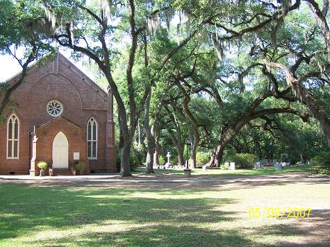
Page 11 This is going to go fast since I'm fried. Basically hidden at the corner of La.66 and US.61 is this "good intentions" display of a rural homestead. I guess lack of funds has closed it down to the "by appointment only" status. It is a reproduction. I stopped by Locust Grove Historical Site which is a museum. You need to research it. This is all I have. HERE There is an example of an old cemetery there. I've seen one or two of those but this one has a few interesting resteeze. It was getting late and it's getting late now. All right, the terms to research are: John Mills Bayou Sara West Florida Rebellion Danial Turnbull Rosedown Plantation One picture can open worlds of information. On this one it's your turn. Terms to look up: *Bishop Leonidas Polk*. (source of the name of Fort Polk. He was also known as the Fighting Bishop. Or, General Polk as Robert E. Lee referred to him. He was everywhere doing church work prior to the Civil War. *Shelling of St.Francisville*was part of the Port Hudson siege. Coming up the hill from the ferry, the church is soon seen on the left as you enter town. It is spectacular. Browse a while. Across the street is what I believe is the old courthouse. I may be wrong. The picture was taken from the shade of the graveyard. More scenes below. Moving toward the ferry and Bayou Sara, high on a hill overlooking Bayou Sara is the OLOMC Cathoic Church, built in 1871which makes it very modern for these parts. Term to look up: *General P.G.T. Beauregard*, a fascinating Frenchman. He had to be Gen.DeGaulle's grandfather. Below the church is this marker. I crossed on the ferry and made it back to Lottie where I took a break looking up the levee. The display at La.66 and US 61


Locust Grove

History Marker (home not visible)

The Episcopal Church

The Courthouse

Epicopal Church Cemetery

The Church HM

Church Grounds

HM There's that Mills Fella

"New" Catholic Church.

They were latecomers.

Lotta Levee @ Lottie.

The ride had been a good one. Any one you come back from is good. Something was missing though. It seemed that on every foray the result was a partial bummer. I've been on a roll for a long time. One success after another has gotten me spoiled. Maybe this one was just a bit off. Writing it was a job, one I promised myself to do. More enthusiasm will have to propel the next one. See ya around the bend, along some river.. That other ride I referred to is on the Southeastern Louisiana Table of Contents Page. It is named Ride to Tunica or something equally intriguing.
Mississippi Magic, November 1961
Published by the Mississippi Agricultural and Industrial Board
This Tiny Mississippi Village Was Once The Center Of An International " Cold War"
In 1798, the southwestern corner of United States property was the Territory of Mississippi, on the Mississippi river. Right across the river was Spanish territory, and the struggle for possession of America was still on.
The Spanish had just withdrawn from the Natchez territory, and the United States needed a frontier post on the river just across from the land still claimed by Spain.
Some 38 miles south of Natchez was a high hill known first as "Roche a Davion" for a French missionary who established a mission there among the Tunica Indians in 1698, and then as Loftus Heights after 1764, when the British took over.
The site was recommended by a Captain Guion, and the fort was built in 1799 after the arrival of General James Wilkinson as the commanding officer - the man for whom Wilkinson county was named.
The engineering work was done under the direction of Major Thomas Freeman, who had been acting as surveyor of the boundary line between American and Spanish holdings. And the frontier post was named after John Adams, who was then president of the United States.
In 1801, General Wilkinson negotiated a treaty with the Choctaw Indians for re-surveying the British line from the Yazoo river southward, marking the limits of the Natchez district, and also for a road through Choctaw country north to Chickasaw country and then to Nashville - a road which became known as the famous Natchez Trace.
A few months ago, a team from the Smithsonian Institution in Washington, D. C., together with officials of the Mississippi Department of Archives and History, visited the site of the old fort and found nothing but a few buttons and pieces of glass.
Fortunately, the National Archives, in Washington, has the plan of the fort, which we are happy to show MAGIC readers on this page. The site, when these plans were drawn, was known as Loftus Heights.
The fort had a garrison of about 500 regular United States troops. The stronghold included a strong earthwork, a powder magazine and barracks. It served as the United States port of entry on the Mississippi river, and export-import duties were collected there until the purchase of the Louisiana Territory in 1803 shifted this work to New Orleans.
Fort Adams was the setting for Edward E. Hale's famous story, "The Man Without a Country." Meriwether Lewis, of the famed Lewis-Clark expedition, lived for a time at Fort Adams before leaving for Washington, D. C., to be-come private secretary to President Thomas Jefferson.
The importance of Fort Adams in 1803 is reflected in a letter written that year to William C. C. Claiborne, governor of the Territory of Mississippi, by General James Wilkinson, its commanding officer, for whom Wilkinson county was named.
"I hold this point to be the door to our whole western country. And while we keep it barred, we shall be able to secure and control the interior - a consideration paramount to all others and which would justify the abandonment of every inferior object."
After American acquisition of Louisiana through the Louisiana Purchase, the Spanish threat disappeared, and Fort Adams was abandoned. The little town nearby, which had also taken on the name Fort Adams, remained. But during the War Between the States, a federal boat, the "Chilicothe," was stationed at the foot of the hill so long that the drift of the river around the boat caused the channel of the river to change more than a mile from the old fort site.

DESCRIPTION OF THE NATCHEZ INDIANS This remarkable tribe, the most civilized of all the original inhabitants of the States, dwelt in the vicinity of the present city of Natchez. In refinement and intelligence, they were equal, if not superior, to any other tribe north of Mexico. In courage and stratagem they were inferior to none. Their form was noble and commanding; their statue was seldom under 6 feet, and their persons were straight and athletic. Their countenance indicated more intelligence than is commonly found in savages. The head was compressed from the os frontis to the occipat, so that the forehead appeared high and retreating, while the occiput was compressed almost as a line with the neck and shoulders. This peculiarity, as well as their straight, erect form, is ascribed to the pressure of bandages during infancy. Their religion, in some respects, resembled that of the fire-worshipers of Persia. Fire was the emblem of their divinity; the sun was their god; their chiefs were called "suns," and their king was called the "Great Sun." In their principal temple a perpetual fire was kept burning by the ministering priest, who likewise offered sacrifices of the first fruits of the chase. In extreme cases, they offered sacrifices of infant children, to appease the wrath of the deity. When Iberville was there, one of the temples was struck by lightning and wet on fire. The keeper of the flame solicited the squaws to throw their little ones into the fire to appease the angry divinity, and four infants were thus sacrificed before the French could prevail on them to desist from the horrid rites. FRENCH INFLUENCE After the Frenchman Iberville reached the Natchez tribe, the Great Sun, or king of the confederacy, having heard of the approach of the French commandant, determined to pay him a visit in person. As he advanced to the quarters of Iberville, he was borne upon the shoulders of some of his men, and attended by a great retinues of his people. He bade Iberville a hearty welcome, and showed him the most marked attention and kindness during his stay. A treaty of friendship was concluded, with permission to build a fort and to establish a trading-post among them; which was, however, deferred for many years. A few stragglers soon after took up their abode among the Natchez; But no regular settlement was made until 1716, when Bienville, Governor of Louisiana, erected Fort Rosalie, which stood near the eastern limit of the present city of Natchez. Grand, or Great Sun, the chief of the Natchez, was at first the friend of the whites, until the overbearing disposition of one man brought destruction on the whole colony. The residence of the Great Sun was a beautiful village called the White Apple. This village spread over a space of nearly three miles in extent, and stood about 12 miles south of the fort, near the mouth of Second Creek, and three miles east of the Mississippi. M. de Chopart, the commandant, was guilty of great injustice toward the Indians, and went so far as to command the Great Sun to leave the village of his ancestors, as he wanted the ground for his own purposes. The Great Sun, finding Chopart deaf to all his entreaties, formed a plot to rid his country of the tyrant who oppressed them. Previous to the tragedy, the Sieur de Mace, ensign of the garrison, received advice of the intention of the Natchez, through a young Indian girl who loved him. She told him, crying, that her nation intended to massacre the French. Amazed at this story, he questioned his mistress. Her simple answers, and her tender tears, left him no room to doubt of the plot. He informed Chopart of it, who forthwith put him under arrest for giving a false alarm. THE MASSACRE The following is from Monette's History of the Valley of the Mississippi: "At length the fatal day arrived. It was November 29th, 1729. Early in the morning Great Sun repaired, with a few chosen warriors, to Fort Rosalie, and all were well armed with knives and other concealed weapons. "The company had recently set up a large supply of powder and lead, and provisions for the use of the post. The Indians had recourse to stratagem to procure a supply of ammunition, pretending that they were preparing for a great hunting excursion. Before they set out, they wished to purchase a supply of ammunition, and they had brought corn and poultry to barter for powder and lead. Having placed the garrison off their guard, a number of Indians were permitted to enter the fort, and others were distributed about the company's warehouse. Upon a certain signal from the Great Sun, the Indians immediately drew their concealed weapons, and commenced the carnage by one simultaneous and furious massacre of the garrison, and all who were in and near the warehouse. "Other parities, distributed through the contiguous settlements, carried on the bloody work in every house as son as the smoke was seen to rise from the houses near the fort. "The massacre commenced at 9 o'clock in the morning, and before noon the whole of the male population of the French colony on St. Catharine (consisting of about 700 souls) were sleeping the sleep of death. The slaves were spared for the service of the victors, and the females and children were reserved as prisoners of war. Chopart fell among the first victims; and, as the chiefs disdained to stain their hands with his despised blood, he was dispatched by the hand of a common Indian. Two mechanics, a tailor, and a carpenter were spared, because they might be useful to the Indians. "While the massacre was progressing, the Great Sun seated himself in the spacious warehouse of the company, and, with apparent unconcern and complacency, sat and smoked his pipe while his warriors were depositing the heads of the French garrison in a pyramid at his feet. The head of Chopart was placed in the center, surmounting those of his officers and soldiers. So soon as the warriors informed the Great Sun that the last Frenchman had ceased to live, he commanded the pillage to commence. The negro slaves were employed in bringing out the plunder for distribution. The powder and military stores were reserved for public use in future emergencies. "While the ardent spirits remained, the day and the night alike presented one continued scene of savage triumph and drunken revelry. With horrid yells they spent their orgies in dancing over the mangled bodies of their enemies, which lay strewed in every quarter where they had fallen in the general carnage. Here, unburied, they remained a prey for dogs and hungry vultures. Every vestige of the homes and dwellings in all the settlements were reduced to ashes. "Two soldiers only, who happened to be absent in the woods at the time of the massacre, escaped to bear the melancholy tidings to New Orleans. As they approached the fort and hear the deafening yells of the savages, and saw the columns of smoke and flame ascending from the buildings, they well judged the fate of their countrymen. They concealed themselves until they could procure a boat or canoe to descend the river to New Orleans, where they arrived a few days afterward, and told the sad story of the colony on the St. Catharine. "The same fate was shared by the colony on the Yazoo, near Fort. St. Peter, and by those on the Washita, at Sicily Island, and near the present town of Monroe. Dismay and terror were spread over every settlement in the province. New Orleans was filled with mourning and sadness for the fate of friends and countrymen. "The whole number of victims slain in this massacre amounted to more than 200 men, besides a few women and some negroes, who attempted to defend their masters. Ninety-two women and 155 children were taken prisoners. Among the victims were Father Poisson, the Jesuit missionary; Laloire, the principal agent of the company; M. Kollys and Son, who had purchased M. Hubert's interest, and had just arrived to take possession." AFTERMATH AND EXTINCTION When the news of this terrible disaster reached New Orleans, the French commenced a war of extermination against the Natchez. The tribe eventually were driven across the Mississippi, and finally scattered and extirpated. The Great Sun and his principal war chiefs, falling into the hands of the French, were shipped to St. Domingo and sold as slaves. Some of the poor prisoners were treated with excessive cruelty; four of the men and two of the women were publicly burned to death at New Orleans. Some Tonica Indians, who had brought down a Natchez woman, whom they had discovered in the woods, were allowed to execute her in the same manner. The unfortunate woman was led forth to a platform consumed by the flames! She supported her tortures with stoical fortitude, not shedding a tear. "On the contrary," says Gayarre, "she upbraided her torturers with their want of skill, flinging at them every opprobrious epithet she could think of." The scattered remnants of the tribe sought an asylum among the Chickasaws and other tribes who were hostile to the French. Since that time, the individuality of the Natchez tribe has been swallowed up in the nations with whom they were incorporated. yet no tribe has left no proud a memorial of their courage, their independent spirit, and their contempt of death in defense of their rights and liberties. The City of Natchez is their monument, standing upon the field of their glory. Some of the remaining individuals of the Natchez tribe were in the town of Natchez as late as the year 1782, more than half a century after the Natchez massacre. Such is the brief history of the Natchez Indians, who are now considered extinct.