I must congratulate myself in advance for arranging each subject found in the "OF" so neatly. "Neat" is not one of my strengths. "Accumulating" is.
Without further self absorption, here we go: This has not, and will not, be proof read. It is just "stuff", a hated word, but one that fits.
RR Pictures
Here we have an unrelated group of pictures gathered along the way. (Titles found (most of the time on top of the pictures.
This fella was the station manager at Lafayette La.back in the early 1900's.
He was a Cornay, a direct descendant of the famous Captain Cornay of the
Civil War "Red River Campaign"

Here is one of my favorite pictures because I'm in it. It was taken in south New Iberia.

This picture was a mystery. We could not decide where the depot was located until someone identified it as "Norco",

Below are the two rail bridges over the Calcasieu River at Lake Charles. The KCS bridge is at the top (north) and the Southern Pacific bridge is to the south.which makes keeping them straight, easy. The picture
was probably taken from above.

Below is an eastbound train after crossing the SP bridge.
Some of these pictures are larger than presented. Clicking on them will get you the original uploads suitable for downloading, just a hint for all the "collectors", such as myself, out there.

One discussion involved "combination cars".
Below is a "wooden combine" at New Iberia.
Yes, it is clickable.

The Invisible Windmill Train
This one snuck by one of the most ardent observers of rail traffic.
My belief in his credentials made me think I had dreamed it, but the camera does not lie.
I chased it all the way from the Lafayette Yard to New Iberia.
Again, this one is clickable. If you doubt the validity of the pictures, check out how each is labelled.

Amtrak Saturday
For some reason I haven't thrown these into the pile of Amtrak pictures.
I know that no one is interested in Amtrak pictures because they are so mundane.
Steam engines were once mundane. I rest my case.
Clickable.

Next is
Book Excerpts
These are great and will probably fill your day reading them.


Red and Atchafalaya Rivers

Take a deep breath, there are many to come.
Labelled "KCS Book".


Staying with the KCS theme, I copied these.


KCS History Lesson


Next:


All good obits deserve a few ads.


Next: Downloaded Maps CLICK
The Alexandria & Western RR.

Thibodaux Murry drew all over these.

Franklin Jeanerette

A FEW MORE Murry drew on.
Historic Railroad, Lumber Industry and Other Transportation-Related Maps
Maps illustrating historic railroad, water, stage or other transportation routes in Texas, Louisiana, Arkansas and
Oklahoma. Sorted by subject-date.
A - B - C - D - E - F - G - H - G - H - I - J - K - L - M - N - O - P - Q - R - S - T - U - V - W - XYZ
A
Abilene & Northern Ry. (Tex.) 1908 Rand-McNally Commercial Atlas
Abilene & Southern Ry. (Tex.) 1937 Rand-McNally Commercial Atlas
Abilene & Southern Ry. (Abilene, Tex.) 1957 USGS Topographic Map
Alexandria Lumber Co. (La.) 1916 USDA Soil Survey Map
Alexandria and Pineville, La. 1916 USDA Soil Survey Map
Alexandria & Western Ry. (La.) 1916 USDA Soil Survey Map
Alexandria & Western Ry. (La.) 1920 Railroad Commission of Louisiana Atlas
Alexandria & Western Ry. (La.) 1922 Railroad Commission of Louisiana Atlas
Amos Kent Lumber & Brick Co. (La.) 1906 Post Route Map
Angelina County Lbr. Co. (Chireno, Tex.) 1937 U.S. Forest Service Map
Angelina County Lbr. Co. (Nancy, Tex.) 1928 USGS 7.5-Minute Series Topographic Map
Angelina County Lbr. Co. (Nancy, Tex.) 1928 USGS 15-Minute Series Topographic Map
Angelina Hardwood Co. (Tex.) 1937 U.S. Forest Service Map
Angelina & Neches River R.R. (Tex.) 1937 Rand-McNally Commercial Atlas
Aransas Harbor Terminal Ry. (Tex.) 1910 ca. Proposed Construction; Unknown Source
Aransas Harbor Terminal Ry. (Tex.) 1923 USGS Topographic Map
Arkana & Eastern R.R. (La.) 1907 Cram Railway Atlas
Arkansas & Gulf R.R. (La.) 1913 Railroad Commission of Louisiana Atlas
Arkansas & Gulf R.R. (La.) 1914 Railroad Commission of Louisiana Atlas
Arkansas & Gulf R.R. (La.) 1922 Public Service Commission of Louisiana Atlas
Arkansas & Louisiana Missouri Ry. (La.) 1929 Official Guide of the Railways Timetable Map
Arkansas Southeastern R.R. (La.) 1903 Cram Railway Atlas
Arkansas Southeastern R.R. (La.) 1906 Official Guide of the Railways Timetable Map
Arkansas Southeastern R.R. (La.) 1913 Railroad Commission of Louisiana Atlas
Arkansas Southeastern R.R. (La.) 1914 Railroad Commission of Louisiana Atlas
Arkansas Southern R.R. (La.) 1913 Railroad Commission of Louisiana Atlas
Arkansas Southern R.R. (La.) 1914 Railroad Commission of Louisiana Atlas
Artesian Belt Ry. (Tex.) 1912 Rand-McNally Commercial Atlas
Artesian Belt Ry. (Tex.) 1913 USDA Soil Survey Map
Ascension Red Cypress Co. (La.) 1922 Public Service Commission of Louisiana Atlas
Asherton & Gulf Ry. (Tex.) 1912 Rand-McNally Commercial Atlas
Asherton & Gulf Ry. (Tex.) 1936 Texas Highway Department County Map
Asherton & Gulf Ry. (Tex.) 1943 USDA Soil Survey Map
Asherton & Gulf Ry. (Tex.) 1949 USDA Soil Survey Map
Ashley & Inverness R.R. (La.) 1896 Cram Railway Atlas
Ashley & Inverness R.R. (La.) 1898 Cram Railway Atlas
Asphalt Belt Ry. (Tex.) 1936 Texas Highway Department County Map
Asphalt Belt Ry. (Tex.) 1937 Rand-McNally Commercial Atlas
Athens & Southeastern R.R. (La.) 1913 Railroad Commission of Louisiana Atlas
Athens & Southeastern R.R. (La.) 1914 Railroad Commission of Louisiana Atlas
Atlanta & Mount Pleasant R.R. (Tex.) 1895 Cram Railway Atlas
Austin & Northwestern Ry. (Tex.) 1907 Rand-McNally Commercial Atlas
[top]
B
Banner Lumber Co. (La.) 1906 Post Route Map
Bastrop & Lake Providence Ry. (La.) 1920 Railroad Commission of Louisiana Atlas
Bastrop & Lake Providence Ry. (La.) 1922 Public Service Commission of Louisiana Atlas
Beaumont & Great Northern Ry. (Onalaska (Tex.) 1918 Interstate Commerce Commission Valuation Map
Beaumont & Saratoga Transportation Co. (Tex.) 1911 Rand-McNally Commercial Atlas
Beaumont & Saratoga Transportation Co. (Tex.) 1916 Rand-McNally Commercial Atlas
Belle Point & Reserve R.R. (La.) 1913 Railroad Commission of Louisiana Atlas
Belle Point & Reserve R.R. (La.) 1914 Railroad Commission of Louisiana Atlas
Belle Point & Reserve R.R. (La.) 1922 Public Service Commission of Louisiana Atlas
Charles Bender & Son Lumber Co. (Tex.) 1919 USGS Topographic Map
Bentley Lumber Co. (La.) 1916 USDA Soil Survey Map
Bernice & Northwestern Ry. (La.) 1913 Railroad Commission of Louisiana Atlas
Big Creek R.R. (La.) 1913 Railroad Commission of Louisiana Atlas
Big Creek R.R. (La.) 1914 Railroad Commission of Louisiana Atlas
Big Pine Lbr. Co. (La.) 1940 Geologic Map
Bivins Lumber Co. (Tex.) 1901 Cram's Standard Railway Atlas
Black Bayou Railroad Co. (Tex.-La.) 1907 USGS Topographic Map
Black Bayou Railroad Co. (Tex.-La.) 1917 Rand-McNally Commercial Atlas
Black Lake Lumber Co. (La.) 1914 Railroad Commission of Louisiana Atlas
Black Lake Lumber Co. (La.) 1922 Public Service Commission of Louisiana Atlas
Bodcaw Valley Ry. (La.) 1913 Railroad Commission of Louisiana Atlas
Bodcaw Valley Ry. (La.) 1920 Railroad Commission of Louisiana Atlas
Bodcaw Valley Ry. (La.) 1922 Public Service Commission of Louisiana Atlas
Bois D'Arc & Southern Ry. (Tex.) 1936 Texas Highway Department County Map
Bois D'Arc & Southern Ry. (Tex.) 1940 USDA Soil Survey
Boleyn Lumber Co. (La.) 1920 Railroad Commission of Louisiana Atlas
Bowie Lumber Co. (La.) 1913 Railroad Commission of Louisiana Atlas
Bowie Lumber Co. (La.) 1914 Railroad Commission of Louisiana Atlas
Bowie Lumber Co. (La.) 1920 Railroad Commission of Louisiana Atlas
Bowie Lumber Co. (La.) 1922 Public Service Commission of Louisiana Atlas
Bowman-Hicks Lumber Co. (La.) 1918 Louisiana Reporter Exhibit Map
Bradford-Hicks Lumber Co. (Dyersdale, Tex.) 1916 USGS Topographic Map
Brakenridge Railway & Navigation Co. (La.) 1913 Railroad Commission of Louisiana Atlas
Brakenridge Railway & Navigation Co. (La.) 1914 Railroad Commission of Louisiana Atlas
Brakenridge Railway & Navigation Co. (La.) 1922 Public Service Commission of Louisiana Atlas
Brimstone Railway & Canal Co. (La.) 1913 Railroad Commission of Louisiana Atlas
Brimstone Railway & Canal Co. (La.) 1922 Public Service Commission of Louisiana Atlas
Brownsville-Matamoros Bridge Co. (Tex.) 1926 Interstate Commerce Commission Reference Map
Brownwood North & South Railway Co. (Tex.) 1912 Rand-McNally Commercial Atlas
Brownwood North & South Railway Co. (Tex.) 1918 USGS Topographic Map
Bryan & Central Texas Interurban Ry. (Tex.) 1914 USDA Soil Survey Map
Bryan & College Interurban Ry. (Tex.) 1914 USDA Soil Survey Map
Buffalo Bayou, Brazos & Colorado R.R. (Tex.) 1865 Records of the Civil War Atlas
Buffalo Bayou, Brazos & Colorado R.R. (Tex.) 1871 Asher & Adams Atlas
Burr's Ferry, Browndell & Chester Ry. (Tex.) 1908 Rand-McNally Commercial Atlas
[top]
C
Wm. Cady Lumber Co. (La.) 1916 USDA Soil Survey Map
Call, Newton County, Tex. 1936 Texas Highway Department Map
Camp Ruby, Polk County, Tex. 1936 Texas Highway Department Map
Caro Northern Ry. (Tex.) 1924 USDA Soil Survey Map
Carter-Kelley Lumber Co. Tram (Tex.) 1937 U.S. Forest Service Map
W.T. Carter & Bro. Lbr. Co. (Tex.) 1936 Texas Highway Department Map
Choctaw Lumber & Veneer Co. (Okla.) 1908 Cram's Standard Railway Atlas
Christie & Eastern Ry. (Peavy-Wilson Lbr.) (La.) 1920 Railroad Commission of Louisiana Atlas
Christie & Eastern Ry. (Peavy-Wilson Lbr.) (La.) 1922 Public Service Commission of Louisiana Atlas
Cinclaire Central Factory (La.) 1913 Railroad Commission of Louisiana Atlas
Cinclaire Central Factory (La.) 1914 Railroad Commission of Louisiana Atlas
Cinclaire Central Factory (La.) 1922 Public Service Commission of Louisiana Atlas
Cisco & Northeastern Ry. (Tex.) 1937 Rand-McNally Commercial Atlas
Clark & Boice Lumber Co. (Tex.) 1918 Interstate Commerce Commission Valuation Map
Clark & Boice Lumber Co. (Tex.) 1938 USGS Special Bulletin Reference Map
Colmesneil & Alexandria R.R. (Tex.) 1895 Rand-McNally Commercial Atlas
Cotton Belt System (Tex.-Ark.) 1906 Official Guide of Railway Listing Map
Cotton Belt System (Tex.-Ark.) 1957 Cotton Belt News Historical Timeline Map
Cow Creek Tram Co. (Tex.) 1895 Rand-McNally Commercial Atlas
Crosbyton-South Plains R.R. (Tex.) 1915 Rand-McNally Commercial Atlas
Crystal City & Uvalde Ry. (Tex.) 1911 USDA Soil Survey Map
Crystal City & Uvalde Ry. (Tex.) 1912 Rand-McNally Commercial Atlas
[top]
D
Dallas, Tex. 1895 Cram's Universal Atlas
Dallas, Tex., Deep Ellum section. 1895 Cram's Universal Atlas
Davis Brothers Lbr. Co. (La.) 1913 Railroad Commission of Louisiana Atlas
Davis Brothers Lbr. Co. (La.) 1920 Railroad Commission of Louisiana Atlas
DeKalb & Red River R.R. (Tex.) 1901 Cram's Atlas of the World
Delhi, Baskin & Southwestern Ry. (La.) 1913 Railroad Commission of Louisiana Atlas
Delhi, Baskin & Southwestern Ry. (La.) 1914 Railroad Commission of Louisiana Atlas
Delhi, Baskin & Southwestern Ry. (La.) 1922 Public Service Commission of Louisiana Atlas
Denison & Pacific Suburban Ry. (Tex.) 1901 USGS Topographic Map
Denison & Pacific Suburban Ry. (Tex.) 1909 USDA Soil Survey Map
Denison & Sherman Ry. (Tex.) 1909 USDA Soil Survey Map
Derry & Southwestern R.R. (La.) 1921 USDA Soil Survey Map
Dierks Lumber Co. (Okla.) 1948 USGS Topographic Map
Dorcheat Valley R.R. (La.) 1913 Railroad Commission of Louisiana Atlas
Dorcheat Valley R.R. (La.) 1914 USDA Soil Survey Map
Dubach Lumber Co. (La.) 1915 Southwestern Reporter Case Exhibit Map
[top]
E
East Texas & Gulf Ry. (Tex.) 1917 Texas Railroad Commission Reference Map
East Texas Transportation Co. (Tex.,Ark.,La.) 1901 Rand-McNally Commercial Atlas
Eastern Texas R.R., Kennard to Druso (Tex.) 1905 USDA Soil Survey Map
Eastern Texas R.R., Kennard and Ratcliff (Tex.) 1905 USDA Soil Survey Map
Eastern Texas R.R., trams (Tex.) 1905 USDA Soil Survey Map
East Texas & Gulf Ry. (Tex.) 1917 Interstate Commerce Commission Reference Map
Elmina & Eastern R.R. (Tex.) 19?? Unknown source, Texas Railroad Commission files.
Elmina & Eastern R.R. (Tex.) 1937 U.S. Forest Service Map
Emporia & Gulf R.R. (Tex.) 1906 Rand-McNally Commercial Atlas
Enterprise Ry. (La.) 1913 Railroad Commission of Louisiana Atlas
Enterprise Ry. (La.) 1914 Railroad Commission of Louisiana Atlas
Enterprise Ry. (La.) 1920 Railroad Commission of Louisiana Atlas
Estacado & Gulf R.R. (Tex.) 1906 Rand-McNally Commercial Atlas
[top]
F
H.B. Fall Lumber Co. (Willow, Tex.) 1916 USGS Topographic Map
Feliciana Eastern R.R. (La.) 1954 USGS Topographic Map
Fort Worth Belt Ry. (Tex.) 1918 Interstate Commerce Commission Map
Fort Worth Union Station (Tex.) 1916 Interstate Commerce Commission Map
Foster Lumber Co. (Tex.) 1938 U.S. Forest Service Map
Fostoria & Northern Transportation Co. (Tex.) 1908 Rand-McNally Commercial Atlas
Fostoria & Northern Transportation Co. (Tex.) 1912 Rand-McNally Commercial Atlas
Franklin & Abbeville R.R. (La.) 1910 Official Guide of the Railways Listing
Franklin & Abbeville R.R. (La.) 1913 Railroad Commission of Louisiana Atlas
Franklin & Abbeville R.R. (La.) 1914 Railroad Commission of Louisiana Atlas
Franklin & Abbeville R.R. (La.) 1922 Public Service Commission of Louisiana Atlas
Frost-Johnson Lumber Co. (Campti, La.) 1921 USDA Soil Survey Map
Frost Lumber Industries (Nacogdoches, Tex.) 1936 Texas Highway Department County Map
[top]
G
Galveston, Beaumont & Northeastern Ry. (Tex.) 1910 American Lumberman Illustration Map for the GB&NE
Galveston, Beaumont & Northeastern Ry. (Tex.) 1910 American Lumberman Illustration Map "Peach River Lines"
Galveston-Port Bolivar Ferry (Tex.) 1935 USDA Soil Survey
Galveston Terminal Co. (Tex.) 1919 ICC Reference Map
Galveston Wharf Co. (Tex.) 1917 ICC Reference Map
Garyville Northern R.R. (La.) 1922 Public Service Commission of Louisiana Atlas
Genesee Lumber Co. (La.) 1913 Railroad Commission of Louisiana Atlas
Glenmora & Western Ry. (La.) 1913 Railroad Commission of Louisiana Atlas
Glenmora & Western Ry. (La.) 1922 Public Service Commission of Louisiana Atlas
Grant Land & Lbr. Co. (La.) 1914 Railroad Commission of Louisiana Atlas
Great Southern Lbr. Co. (La.) 1908 American Lumberman Illustration Map
Groveton, Lufkin & Northern Ry. (Tex.) 1909 Rand-McNally Commercial Atlas
Gulf Coast Lines (Tex.-La.) 1910 Official Guide of the Railways Listing Map
Gulf, Colorado & Santa Fe Ry. (Tex.-La.) 1929 Official Guide of the Railways Listing Map
Gulf & Interstate Ry. (Tex.) 1910 Official Guide of the Railways Listing Map
Gulf & Interstate Ry. (Port Bolivar, Tex.) 1935 USDA Soil Survey Map
Gulf & Northern R.R. (Tex.) 1936 Texas Highway Department County Map
Gulf, Sabine & Red River R.R. (La.) 1913 Railroad Commission of Louisiana Atlas
Gulf, Sabine & Red River R.R. (La.) 1914 Railroad Commission of Louisiana Atlas
Gulf, Sabine & Red River R.R. (La.) 1920 Railroad Commission of Louisiana Atlas
Gulf, Sabine & Red River R.R. (La.) 1922 Public Service Commission of Louisiana Atlas
Gulf & Sabine River R.R., Nitram branch (La.) 1914 Railroad Commission of Louisiana Atlas
Gulf & Sabine River R.R., Stables branch (La.) 1914 Railroad Commission of Louisiana Atlas
Gulf & Sabine River R.R. (La.) 1920 Railroad Commission of Louisiana Atlas
Gulf, Texas & Western Ry., proposed (Tex.) 1910 Poor's Manual of Railroads
Gulf, Texas & Western Ry. (Tex.) 1913 Rand-McNally Commercial Atlas
[top]
H
Hamlin & Northwestern Ry. (Tex.) 1936 Texas Highway Department County Map
Hammond & Eastern R.R. (La.) 1913 Railroad Commission of Louisiana Atlas
Hammond & Eastern R.R. (La.) 1914 Railroad Commission of Louisiana Atlas
Hammond & Houltonville R.R. (La.) 1920 Railroad Commission of Louisiana Atlas
Hearne & Brazos Valley Ry. (Tex.) 1912 Rand-McNally Commercial Atlas
Harleton and Pine Ridge, Harrison County, Tex. 1912 USDA Soil Survey Map
Hoffman Heading & Stave Co., former tram (Tex.) 1909 USDA Soil Survey Map
Houlton Lumber Co. (La.) 1920 Railroad Commission of Louisiana Atlas
Houston Tap & Brazoria Ry. (Tex.) 1865 Records of the Civil War Atlas
Houston & Texas Central R.R. (Tex.) 1906 Official Guide of Railways Listing Map
Houston & Texas Central R.R., former Austin &
Northwestern R.R. (Tex.)
1912 Rand-McNally Commercial Atlas
Hudson River Lbr. Co. (La.) 1914 Railroad Commission of Louisiana Atlas
Hudson River Lbr. Co. (La.) 1920 Railroad Commission of Louisiana Atlas
Hudson River Lbr. Co. (La.) 1922 Public Service Commission of Louisiana Atlas
Huntsville Branch R.R. (Tex.) 1938 U.S. Forest Service Map
[top]
I
Iberia & Vermillion R.R. (Tex.) 1913 Railroad Commission of Louisiana Atlas
International-Great Northern R.R. (Tex.) 1906 Official Guide of Railways Listing Map
Industrial Lbr. Co., (Elizabeth (La.) 1913 Railroad Commission of Louisiana Atlas
Industrial Lbr. Co., (Elizabeth (La.) 1914 Railroad Commission of Louisiana Atlas
Industrial Lbr. Co., (Elizabeth (La.) 1920 Railroad Commission of Louisiana Atlas
Industrial Lbr. Co., (Elizabeth (La.) 1922 Public Service Commission of Louisiana Atlas
Industrial Lbr. Co. (Vinton, La.) 1913 Railroad Commission of Louisiana Atlas
Industrial Lbr. Co. (Vinton, La.) 1914 Railroad Commission of Louisiana Atlas
Industrial Lbr. Co. (Vinton, La.) 1922 Public Service Commission of Louisiana Atlas
[top]
J
Jackson Railroad (La.) 1912 USDA Soil Survey Map
Jasper & Eastern Ry. (Tex.-La.) 1913 Railroad Commission of Louisiana Atlas
Jasper & Eastern Ry. (Tex.-La.) 1920 Railroad Commission of Louisiana Atlas
Jasper Lumber Co. (Tex.) 1936 Texas Highway Department County Map
Jefferson & Northwestern R.R. (Jefferson, Tex.) 1918 Interstate Commerce Commission Engineering Map
Jefferson & Northwestern R.R. (Linden, Tex.) 1918 Interstate Commerce Commission Engineering Map
Jefferson & Northwestern R.R. (Tex.) 1930 Rand-McNally Commercial Atlas
Jefferson & Northwestern R.R. (Tex.) 1933 USDA Soil Survey Map
Jefferson & Northwestern R.R. (Tex.) 1936 Texas Highway Department County Map
Jefferson & Northwestern R.R. (Tex.) 1938 USGS Special Bulletin Reference Map
[top]
K
Kansas City, Mexico & Orient R.R. (Tex., Okla., Kans.,
Mo.)
1906 Official Guide of Railways Listing Map
Kansas City Southern (Tex., Okla., La., Ark., Mo.) 1906 Official Guide of Railways Listing Map
Kentwood & Eastern Ry. (La.) 1905 USDA Soil Survey Map
Kentwood & Eastern Ry. (La.) 1913 Railroad Commission of Louisiana Atlas
Kentwood & Eastern Ry. (La.) 1914 Railroad Commission of Louisiana Atlas
Kentwood & Eastern Ry. (La.) 1920 Railroad Commission of Louisiana Atlas
Kentwood & Eastern Ry. (La.) 1922 Public Service Commission of Louisiana Atlas
Kentwood, Greensburg & Southwestern RR (La.) 1908 Rand-McNally Commercial Atlas
Kentwood, Greensburg & Southwestern RR (La.) 1913 Railroad Commission of Louisiana Atlas
Kentwood, Greensburg & Southwestern RR (La.) 1914 Railroad Commission of Louisiana Atlas
Kentwood, Greensburg & Southwestern RR (La.) 1920 Railroad Commission of Louisiana Atlas
Keystone Mills Co. Tram (Tex.) 1937 U.S. Forest Service Map
Kinder & Northwestern R.R. (La.) 1920 Railroad Commission of Louisiana Atlas
Kinder & Northwestern R.R. (La.) 1922 Public Service Commission of Louisiana Atlas
King-Ryder Lbr. Co. (Thomasville, Okla.) 1901 Cram's Atlas of the World
King-Ryder Lbr. Co. (Bonami, La.) 1914 Railroad Commission of Louisiana Atlas
King-Ryder Lbr. Co. (Bonami, La.) 1922 Public Service Commission of Louisiana Atlas
Kingston R.R. (La.) 1913 Railroad Commission of Louisiana Atlas
Kingston R.R. (La.) 1914 Railroad Commission of Louisiana Atlas
Kingston R.R. (La.) 1920 Railroad Commission of Louisiana Atlas
Kingston & Choctaw Valley R.R. (Okla.) 1901 Cram's Atlas of the World
Kirby Lumber Co. (Tex.) 1902 American Lumberman Illustration Map
Kirby Lumber Co. (Tex.) 1911 Houston Oil Company Reference Map
Kirby Lumber Co. (Honey Island, Tex.) 1955 USGS Topographic Map
Kirby Lumber Co. (Merryville, La.) 1928 USDA Soil Survey Map
Kirby Lumber Co. (Voth, Tex.) Hand-drawn Map, Undated.
Knox Lumber Co. (Polk County, Tex.) 1906 Texas General Land Office Map
[top]
L
LaFourche, Raceland & Lockport R.R. (La.) 1913 Railroad Commission of Louisiana Atlas
LaFourche, Raceland & Lockport R.R. (La.) 1914 Railroad Commission of Louisiana Atlas
LaFourche, Raceland & Lockport R.R. (La.) 1920 Railroad Commission of Louisiana Atlas
Lake Charles & Northern R.R. (La.) 1913 Railroad Commission of Louisiana Atlas
Lake Charles & Northern R.R. (La.) 1922 Public Service Commission of Louisiana Atlas
Lake Charles Railway & Navigation Co. (La.) 1913 Railroad Commission of Louisiana Atlas
Lake Charles Railway & Navigation Co. (La.) 1914 Railroad Commission of Louisiana Atlas
Lake Charles Railway & Navigation Co. (La.) 1922 Public Service Commission of Louisiana Atlas
Lake Providence, Texarkana & Western R.R. (La.) 1913 Railroad Commission of Louisiana Atlas
Lake Providence, Texarkana & Western R.R. (La.) 1914 Railroad Commission of Louisiana Atlas
Lake Providence, Texarkana & Western R.R. (La.) 1920 Railroad Commission of Louisiana Atlas
Lake Providence, Texarkana & Western R.R. (La.) 1922 Public Service Commission of Louisiana Atlas
Leesville East & West R.R. (La.) 1913 Railroad Commission of Louisiana Atlas
Leesville East & West R.R. (La.) 1914 Railroad Commission of Louisiana Atlas
Leesville East & West R.R. (La.) 1920 Railroad Commission of Louisiana Atlas
Leesville East & West R.R. (La.) 1922 Public Service Commission of Louisiana Atlas
Leesville, Slagle & Eastern Ry. (La.) 1922 Public Service Commission of Louisiana Atlas
Livingston & Southeastern Ry. 1906 Texas General Land Office Map
Lodwick Lumber Co. (Tex.) 1917 Interstate Commerce Commission Reference Map
Long-Bell Lumber Co. (Allentown, La.) 1913 Railroad Commission of Louisiana Atlas
Longville Lbr. Co. (La.) 1914 Railroad Commission of Louisiana Atlas
Longville Lbr. Co. (La.) 1920 Railroad Commission of Louisiana Atlas
Longville Lbr. Co. (La.) 1922 Public Service Commission of Louisiana Atlas
Loranger, Louisiana & Northeastern R.R. (La.) 1920 Railroad Commission of Louisiana Atlas
Loranger, Louisiana & Northeastern R.R. (La.) 1922 Public Service Commission of Louisiana Atlas
Louisiana & Arkansas Ry. (La.) 1906 Official Guide of the Railways Listing Map
Louisiana Central R.R. (La.) 1906 American Lumberman Illustration Map
Louisiana Central R.R., Barham branch (La.) 1913 Railroad Commission of Louisiana Atlas
Louisiana Central R.R., Pickering branch (La.) 1913 Railroad Commission of Louisiana Atlas
Louisiana Logging & Lbr. Co. (La.) 1913 Railroad Commission of Louisiana Atlas
Louisiana Logging & Lbr. Co. (La.) 1914 Railroad Commission of Louisiana Atlas
Louisiana Logging & Lbr. Co. (La.) 1920 Railroad Commission of Louisiana Atlas
Louisiana Logging & Lbr. Co. (La.) 1922 Public Service Commission of Louisiana Atlas
Louisiana & Pacific Ry. (La.) 1913 Railroad Commission of Louisiana Atlas
Louisiana & Pacific Ry. (La.) 1914 Railroad Commission of Louisiana Atlas
Louisiana & Pacific Ry. (La.) 1920 Railroad Commission of Louisiana Atlas
Louisiana & Pacific Ry. (La.) 1922 Public Service Commission of Louisiana Atlas
Louisiana & Pacific Ry. (Fisher, La.) 1913 Railroad Commission of Louisiana Atlas
Louisiana Railway & Navigation Co. (Tex., La.) 1906 Official Guide of Railways Listing Map
Louisiana Southern Ry. (La.) 1904 Rand-McNally Commercial Atlas
Louisiana Southern Ry. (La.) 1914 Railroad Commission of Louisiana Atlas
Louisiana Southern Ry. (La.) 1922 Public Service Commission of Louisiana Atlas
Lufkin, Hemphill & Gulf Ry. 1936 Texas Highway Department County Map
Lutcher-Moore Cypress Co. (La.) 1913 Railroad Commission of Louisiana Atlas
Lutcher-Moore Cypress Co. (La.) 1914 Railroad Commission of Louisiana Atlas
Lutcher-Moore Cypress Co. (La.) 1920 Railroad Commission of Louisiana Atlas
Lutcher-Moore Cypress Co. (La.) 1922 Public Service Commission of Louisiana Atlas
Lyon-Cypress Lumber Co. (La.) 1913 Railroad Commission of Louisiana Atlas
[top]
M
Mangham & Northeastern Ry. (La.) 1913 Railroad Commission of Louisiana Atlas
Mansfield Railway & Transportation Co. (La.) 1913 Railroad Commission of Louisiana Atlas
Mansfield Railway & Transportation Co. (La.) 1914 Railroad Commission of Louisiana Atlas
Mansfield Railway & Transportation Co. (La.) 1920 Railroad Commission of Louisiana Atlas
Mansfield Railway & Transportation Co. (La.) 1922 Public Service Commission of Louisiana Atlas
Marshall & East Texas Ry., Marshall to Elysian Fields
(Tex.)
1912 USDA Soil Survey Map
Marshall & East Texas Ry. (Tex.) 1912 Rand-McNally Commercial Atlas
Marshall & East Texas Ry. (Tex.) 1923 Rand-McNally Commercial Atlas
Marshall, Elysian Field & Southeastern Ry. (Tex.) 1936 Texas Highway Department County Map
Martindale & Ouachita River R.R. (La.) 1913 Railroad Commission of Louisiana Atlas
Martindale & Ouachita River R.R. (La.) 1914 Railroad Commission of Louisiana Atlas
Martindale & Ouachita River R.R. (La.) 1920 Railroad Commission of Louisiana Atlas
Martindale & Ouachita River R.R. (La.) 1922 Public Service Commission of Louisiana Atlas
William McCoy Lumber Co. (Tex.-La.) 1907 USGS Topograhic Map
Midland & Northwestern Ry. (Tex.) 1917 Texas Railroad Commission Reference Map
Midland & Northwestern Ry. (Tex.) 1922 Rand-McNally Commercial Atlas
Midland & Northwestern Ry. (Tex.) 1922 USDA Soil Survey Map
Mill Creek & Little River Ry. & Nav. Co. (La.) 1913 Railroad Commission of Louisiana Atlas
Mill Creek & Little River Ry. & Nav. Co. (La.) 1922 Public Service Commission of Louisiana Atlas
Miller Lumber Co. (Okla.) 1910 Cram's Standard Railway Atlas
Miller-Link Lbr. Co. (Tex.) 1926 USGS Topo Map
Milliken & Southwestern R.R. (La.) 1913 Railroad Commission of Louisiana Atlas
Milliken & Southwestern R.R. (La.) 1914 Railroad Commission of Louisiana Atlas
Miltonberg & Southeastern R.R. (La.) 1922 Public Service Commission of Louisiana Atlas
Missouri, Kansas & Texas Ry. of Texas 1910 Official Guide of the Railways Listing
Missouri & Louisiana R.R. (Carson, La.) 1914 Railroad Commission of Louisiana Atlas
Missouri & Louisiana R.R. (Neame, La.) 1914 Railroad Commission of Louisiana Atlas
Missouri, Oklahoma & Gulf Ry. (La.) 1906 Official Guide of the Railways Timetable Map
Monroe & Southwestern Ry. (La.) 1913 Railroad Commission of Louisiana Atlas
Monroe & Southwestern Ry. (La.) 1914 Railroad Commission of Louisiana Atlas
Monroe & Southwestern Ry. (La.) 1920 Railroad Commission of Louisiana Atlas
Monroe & Southwestern Ry. (La.) 1922 Public Service Commission of Louisiana Atlas
Monroe & Texas R.R. (La.) 1920 Railroad Commission of Louisiana Atlas
Moscow, Camden & San Augustine R.R. (Tex.) 1936 Texas Highway Department County Map
Myrtle Springs Short Line R.R. (Tex.) 1895 Rand-McNally Commercial Atlas
[top]
N
Nacogdoches & Southeastern Ry. (Tex.) 1936 Texas Highway Department County Map
Nacogdoches & Southeastern Ry. (Tex.) 1937 Rand-McNally Commercial Atlas
Naples & Sulphur River R.R. (Tex.) 1909 USDA Soil Survey Map
Naples & Sulphur River R.R. (Tex.) 1912 USGS Topographic Map
Natchez, Ball & Shreveport Ry. (La.) 1913 Railroad Commission of Louisiana Atlas
Natchez, Ball & Shreveport Ry. (La.) 1914 Railroad Commission of Louisiana Atlas
Natchez, Ball & Shreveport Ry. (La.) 1920 Railroad Commission of Louisiana Atlas
Natchez, Urania & Ruston Ry. (La.) 1913 Railroad Commission of Louisiana Atlas
Natchez, Urania & Ruston Ry. (La.) 1914 Railroad Commission of Louisiana Atlas
Natchez, Urania & Ruston Ry. (La.) 1920 Railroad Commission of Louisiana Atlas
Natchez, Urania & Ruston Ry. (La.) 1922 Public Service Commission of Louisiana Atlas
Neame, Carson & Southern Ry. (La.) 1920 Railroad Commission of Louisiana Atlas
Neame, Carson & Southern Ry. (La.) 1922 Public Service Commission of Louisiana Atlas
New Iberia & Northern R.R. (La.) 1913 Railroad Commission of Louisiana Atlas
New Iberia & Northern R.R. (La.) 1914 Railroad Commission of Louisiana Atlas
New Iberia & Northern R.R. (La.) 1922 Public Service Commission of Louisiana Atlas
New Orleans Great Northern R.R. (La.) 1913 Railroad Commission of Louisiana Atlas
New Orleans, Natalbany & Natchez Ry. (La.) 1913 Railroad Commission of Louisiana Atlas
New Orleans, Natalbany & Natchez Ry. (La.) 1914 Railroad Commission of Louisiana Atlas
New Orleans, Natalbany & Natchez Ry. (La.) 1920 Railroad Commission of Louisiana Atlas
New Orleans, Natalbany & Natchez Ry. (La.) 1922 Public Service Commission of Louisiana Atlas
New South Lumber Co. (Tex.) 1906 USDA Soil Survey Map
North-East Texas R.R. (Tex.) 1906-1907 USGS Topographic Maps
North-East Texas R.R. (Munz, Tex.) 1906 USGS Topographic Map
North-East Texas R.R. (Redwater, Tex.) 1906-1907 USGS Topographic Maps
North Louisiana & Gulf R.R. (La.) 1913 Railroad Commission of Louisiana Atlas
North Louisiana & Gulf R.R. (La.) 1914 Railroad Commission of Louisiana Atlas
North Louisiana & Gulf R.R. (La.) 1920 Railroad Commission of Louisiana Atlas
North Louisiana & Gulf R.R. (La.) 1922 Public Service Commission of Louisiana Atlas
[top]
O
Oakdale & Gulf Ry. (Oakdale, La.) 1918 Louisiana Reporter Case Exhibit Reference Map
Oakdale & Gulf Ry. (Oakdale, La.) 1920 Railroad Commission of Louisiana Atlas
Oakdale & Gulf Ry. (Oakdale, La.) 1922 Public Service Commission of Louisiana Atlas
Oberlin, Hampton & Eastern R.R. (La.) 1913 Railroad Commission of Louisiana Atlas
Oberlin, Hampton & Eastern R.R. (La.) 1914 Railroad Commission of Louisiana Atlas
Oberlin, Hampton & Eastern R.R. (La.) 1920 Railroad Commission of Louisiana Atlas
Oberlin, Hampton & Eastern R.R. (La.) 1922 Public Service Commission of Louisiana Atlas
Oklahoma & Rich Mountain Ry. (Okla.) 1931 USDA Soil Survey Map
Old River & Kissatchie R.R. (La.) 1913 Railroad Commission of Louisiana Atlas
Old River & Kissatchie R.R. (La.) 1914 Railroad Commission of Louisiana Atlas
Old River & Kissatchie R.R. (La.) 1920 Railroad Commission of Louisiana Atlas
Old River & Kissatchie R.R. (La.) 1922 Public Service Commission of Louisiana Atlas
Olive-Sternenberg Co. (Tex.) 1905-1910c State Reference Map
Opelousas, Gulf & Northeastern Ry. (La.) 1908 Rand-McNally Commercial Atlas
Opelousas, Gulf & Northeastern Ry. (La.) 1913 Railroad Commission of Louisiana Atlas
Opelousas, Gulf & Northeastern Ry. (La.) 1914 Railroad Commission of Louisiana Atlas
Orange, Call & Pine Belt R.R. (Tex.) 1913 Railroad Commission of Louisiana Atlas
Orange, Call & Pine Belt R.R. (Tex.) 1914 Railroad Commission of Louisiana Atlas
Orange, Call & Pine Belt R.R. (Tex.) 1920 Railroad Commission of Louisiana Atlas
Orange & Northwestern Ry. (Tex.) 1913 Railroad Commission of Louisiana Atlas
Orange & Northwestern Ry. (Tex.) 1920 Railroad Commission of Louisiana Atlas
Orange & Northwestern Ry. (Tex.) 1937 Rand-McNally Commercial Atlas
Ouachita & Northwestern R.R. (La.) 1913 Railroad Commission of Louisiana Atlas
Ouachita & Northwestern R.R. (La.) 1914 Railroad Commission of Louisiana Atlas
Ouachita & Northwestern R.R. (La.) 1920 Railroad Commission of Louisiana Atlas
Ouachita & Northwestern R.R. (La.) 1922 Public Service Commission of Louisiana Atlas
Owl Bayou Cypress Company (La.) 1913 Railroad Commission of Louisiana Atlas
Owl Bayou Cypress Company (La.) 1914 Railroad Commission of Louisiana Atlas
Owl Bayou Cypress Company (La.) 1922 Public Service Commission of Louisiana Atlas
[top]
P
Paris & Mount Pleasant R.R. (Tex.) 1909 USDA Soil Survey Map
Paris & Mount Pleasant R.R. (Tex.) 1937 Rand-McNally Commercial Atlas
Peach River & Gulf R.R. (Tex.) 1910 American Lumberman Illustration Map
Peach River & Gulf R.R. (Tex.) 1910 American Lumberman Illustration Map "Peach River Lines"
Peach River & Gulf R.R. (Tex.) 1911 U.S. Army Topographic Map
Peach River Lines (Tex.) 1910 American Lumberman Illustration Map "Peach River Lines"
Pecos Valley Northeastern Ry. (Tex.) 1908 Rand-McNally Commercial Atlas
Pecos Valley Southern Ry. (Tex.) 1915 Rand-McNally Commercial Atlas
Pecos Valley Southern Ry. (Tex.) 1922 USDA Soil Survey Map
Pecos Valley Southern Ry. (Toyahvale, Tex.) 1922 USDA Soil Survey Map
Pecos Valley Southern Ry. (Tex.) 1937 Rand-McNally Commercial Atlas
W.R. Pickering Lbr. Co. (La.) 1906 American Lumberman Illustration Map
W.R. Pickering Lbr. Co. (Cravens, La.) 1906 American Lumberman Illustration Map
W.R. Pickering Lbr. Co. (Haslam, Tex.) 1918 Interstate Commerce Commission Valuation Map
Possible W.R. Pickering Lbr. (Hawthorne, La.) 1922 Public Service Commission of Louisiana Atlas
Port Bolivar-Galveston Ferry (Tex.) 1935 USDA Soil Survey Map
Port Bolivar & Iron Ore R.R. (Tex.) 1917 Interstate Commerce Commission Valuation Map
Port Bolivar & Iron Ore R.R. (Tex.) 1930 Rand-McNally Commercial Atlas
Port Isabel & Rio Grande Valley Ry. (Tex.) 1934 USGS Topographic Map
[top]
Q
Quanah, Acme & Pacific Ry. (Tex.) 1930 Rand-McNally Commercial Atlas
Quanah, Acme & Pacific Ry. (Tex.) 1937 Rand-McNally Commercial Atlas
[top]
R
Red River & Gulf R.R. (La.) 1913 Railroad Commission of Louisiana Atlas
Red River & Gulf R.R. (La.) 1920 Railroad Commission of Louisiana Atlas
Red River & Gulf R.R. (La.) 1922 Public Service Commission of Louisiana Atlas
Red River & Gulf R.R. (La.) 1929 Official Guide of the Railways Listing Map
Red River & Rocky Mount Ry. (La.) 1913 Railroad Commission of Louisiana Atlas
Red River & Rocky Mount Ry. (La.) 1920 Railroad Commission of Louisiana Atlas
Red River & Rocky Mount Ry. (La.) 1922 Public Service Commission of Louisiana Atlas
Rio Grande & Eagle Pass Ry. (Tex.) 1936 Texas Highway Department County Map
Rio Grande & Eagle Pass Ry. (Tex.) 1937 Rand-McNally Commercial Atlas
Rio Grande Micolithic & Northern R.R. (Tex.) 1928 USDA Soil Survey Map
Rio Grande Micolithic & Northern R.R. (Tex.) 1937 Rand-McNally Commercial Atlas
Rio Grande City Ry. (Tex.) 1937 Rand-McNally Commercial Atlas
Rio Grande Northern R.R. (Tex.) 1892 USGS Topographic Map
Riverside & Gulf R.R. (Tex.) 1910 American Lumberman Illustration Map
Riverside & Gulf R.R. (Tex.) 1910 American Lumberman Illustration Map "Peach River Lines"
Rockdale, Texas Area Coal Mines 1925 USDA Soil Survey Map
Rockdale, Sandow & Southern Ry. (Tex.) 1925 USDA Soil Survey Map
Rockdale, Sandow & Southern Ry. (Tex.) 1936 Texas Highway Department County Map
Roosevelt & Western R.R. (La.) 1913 Railroad Commission of Louisiana Atlas
Roosevelt & Western R.R. (La.) 1922 Public Service Commission of Louisiana Atlas
Roscoe, Snyder & Pacific Ry. (Tex.) 1922 USDA Soil Survey Map
Roscoe, Snyder & Pacific Ry. (Tex.) 1923 Rand-McNally Commercial Atlas
Rose Hill Sugar Refining Co. (La.) 1914 Railroad Commission of Louisiana Atlas
Rose Hill Sugar Refining Co. (La.) 1922 Public Service Commission of Louisiana Atlas
[top]
S
San Antonio & Aransas Pass Ry. (Tex.) 1900 ca. System Reference Map
San Antonio & Aransas Pass Ry. (Tex.) 1905-1910 ca. System Reference Map
Sabine & Neches Valley Ry. (Tex.) 1936 Texas Highway Department County Map
Sabine & Northern R.R. (Tex., La.) 1911 ICC "Tap Line Case" Reference Map
Sabine Pass, Tex. 1913 USDA Soil Survey Map
San Antonio & Mexican Gulf R.R. (Tex.) 1865 Records of the Civil War Atlas
San Diego & Gulf Ry. (Tex.) 1937 Rand-McNally Commercial Atlas
Santa Fe Dock & Channel Co. (Tex.) 1916 Interstate Commerce Commission Reference Map
Santo Tomas Coal Co. (Tex.) 1918 USGS Geologic Bulletin Map
Shamrock & Western Ry. (La.) 1913 Railroad Commission of Louisiana Atlas
Shamrock & Western Ry. (La.) 1914 Railroad Commission of Louisiana Atlas
Shreveport, Houston & Gulf R.R. (Tex.) 1937 U.S. Forest Service Map
Shreveport, Houston & Gulf R.R. (Tex.) 1937 Rand-McNally Commercial Atlas
Sibley, Lake Bisteneau & Southern Ry. (La.) 1913 Railroad Commission of Louisiana Atlas
Sibley, Lake Bisteneau & Southern Ry. (La.) 1914 Railroad Commission of Louisiana Atlas
Sibley, Lake Bisteneau & Southern Ry. (La.) 1920 Railroad Commission of Louisiana Atlas
Sibley, Lake Bisteneau & Southern Ry. (La.) 1922 Public Service Commission of Louisiana Atlas
E. Sondheimer Lumber Co. (La.) 1939 USGS Topographic Map
Southern Pacific Terminal Co. (Galveston, Tex.) 1918 Interstate Commerce Commission Reference Map
Southern Pine Lumber Co. (Tex.) 1908 American Lumberman Map Illustration
Southern Pine Lumber Co. (Diboll, Tex.) 1963 USGS Topographic Map
Southern Railway & Navigation Co. (La.) 1913 Railroad Commission of Louisiana Atlas
Southern Railway & Navigation Co. (La.) 1920 Railroad Commission of Louisiana Atlas
South Shore R.R. (La.) 1954 USGS Topographic Map
Southwestern Railway Co. (Tex.) 1912 Rand-McNally Commercial Atlas
Southwestern Railway Co. (Tex.) 1912 USDA Soil Survey Map
Southwestern Railway Co. (Henrietta, Tex.) 1956 USGS Topographic Map
St. Elmo & Belle Helene R.R. (La.) 1914 Railroad Commission of Louisiana Atlas
St. Elmo & Belle Helene R.R. (La.) 1922 Public Service Commission of Louisiana Atlas
St. Louis, Brownsville & Mexico Ry. (Tex.) 1919 Interstate Commerce Commission Reference Map
St. Louis, Brownsville & Mexico Ry., Gulf Coast (Tex.) 1937 Rand-McNally Commercial Atlas
St. Louis, Brownsville & Mexico Ry., deep South
Texas (Tex.)
1937 Rand-McNally Commercial Atlas
St. Louis-Southwestern R.R. (Tex., Ark. Mo.) 1957 Cotton Belt News Historical Timeline Map
Stephenville North & South Texas Ry. (Tex.) 1913 Rand-McNally Commercial Atlas
St. Mary Hardwood Co. (La.) 1922 Public Service Commission of Louisiana Atlas
Sugar Land Railway Co. (Tex.) 1913 Rand-McNally Commercial Atlas
Sullivan-Sanford Lumber Co. (Tex.) 1909 USDA Soil Survey Map
Sullivan-Sanford Lumber Co. (Tex.) 1912 USGS Topographic Map
[top]
T
Tall Timber Lumber Co. (Tex.) 1938 USGS Geologic Map
Temple Lumber Co. (Bronson, Tex.) 1936 Texas Highway Department County Map
Temple Lumber Co. (Hemphill, Tex.) 1936 Texas Highway Department County Map
Temple Lumber Co. (Pineland, Tex.) 1936 Texas Highway Department County Map
Texas, Arkansas & Louisiana Ry. (Tex.) 1907 USGS Topographic Map
Texas Central R.R. (Tex.) 1906 Official Guide of the Railways Listing Map
Texas City Terminal Ry. (Tex.) 1935 USDA Soil Survey Map
Texas City Transportation Co. (Tex.) 1917 Interstate Commerce Commission Reference Map
Texas Electric Ry. (Tex.) 1945 Public Timetable Map
Texas, Louisiana & Eastern R.R. (Tex.) 1895 Rand-McNally Commercial Atlas
Texas-Mexican Ry. (Tex.) 1929 Official Guide of the Railways Listing Map
Texas-Mexican Ry. (Tex.) 1937 Rand-McNally Commercial Atlas
Texas Midland Ry. (Tex.) 1906 Official Guide of Railway Timetable Map
Texas Midland Ry. (Tex.) 1900 ca. System Reference Map
Texas & New Mexico Ry. (Tex., N.Mex.) 1937 Rand-McNally Commercial Atlas
Texas & Northeastern R.R. (Tex.) 1905-1910 ca. System Reference Map
Texas & Pacific Ry. (Tex.-La.) 1906 Official Guide of Railway Listing Map
Texas Short Line Ry. (Tex.) 1936 Texas Highway Department County Map
Texas Short Line Ry. (Tex.) 1937 Rand-McNally Commercial Atlas
Texas Short Line Ry. (Tex.) 1954 USGS Topographic Map
Texas South-Eastern R.R. 1908 American Lumberman Illustration Map
Texas Southern Ry. (Tex.) 1906 Official Guide of Railways (timetable and map)
Texas Southern Ry. (Tex.) 1906 Official Guide of Railways (map only)
Texas Tram & Lumber Co. (Tex.) 1897 Cram's Standard Railway Atlas
Thompson Brothers Lumber Co. (Tex.) 1910-15 ca. Plat Map for Trinity, Tex.
Thompson-Tucker Lumber Co. (Trinity, Tex.) 1910-15 ca. Plat Map for Trinity, Tex.
Thornton & Alexandria Ry. (Ark.) 1906 Official Guide of Railway Listing Map
Timpson & Henderson Ry. (Tex.) 1913 Rand-McNally Commercial Atlas
Tioga & Southeastern Ry. (La.) 1913 Railroad Commission of Louisiana Atlas
Tioga & Southeastern Ry. (La.) 1914 Railroad Commission of Louisiana Atlas
Tioga & Southeastern Ry. (La.) 1922 Public Service Commission of Louisiana Atlas
Tremont & Gulf Ry. (La.) 1906 Official Guide of Railway Listing Map
Tremont & Gulf Ry. (La.) 1910 Official Guide of Railways Listing Map
Tremont & Gulf Ry. (La.) 1911 ICC "Tap Line Case" Reference Map
Tremont & Gulf Ry. (La.) 1913 Rand-McNally Commercial Atlas
Tremont & Gulf Ry. (La.) 1922 Public Service Commission of Louisiana Atlas
Trinity Valley & Northern Ry. (Tex.) 1911 U.S. Army Topographic Map
Trinity Valley & Northern Ry. (Tex.) 1930 Gulf Colorado & Santa Fe Reference Map
Trinity Valley & Northern Ry. (Dayton, Tex.) 1920 Plat or Deed Map
Trinity Valley & Northern Ry. (Dayton, Tex.) 1932 Interstate Commerce Commission Case Exhibit Map
Trinity Valley & Northern Ry. (Luce, Tex.) 1916 USGS Topographic Map
Trinity Valley & Northern Ry. (Macedonia, Tex.) 1920 Interstate Commerce Commission Valuation Map
Trinity Valley Southern Ry. (Tex.) 1929 Official Guide of the Railways Listing Map
Trinity Valley Southern Ry. (Tex.) 1937 U.S. Forest Service Map
[top]
U
Union Terminal Co. (Tex.) 1914 Railway Age Magazine
Union Terminal Company (Tex.) 1917 Interstate Commerce Commission Reference Map
Uvalde & Northern Ry. (Tex.) 1936 Texas Highway Department County Map
Uvalde & Northern Ry. (Tex.) 1937 Rand-McNally Commercial Atlas
Uvalde Street Railway (Tex.) 1910 ca. Engineering Plat Map
[top]
V
Vacherie & Lake Des Allemands R.R. (La.) 1913 Railroad Commission of Louisiana Atlas
Velasco, Brazos & Northern Ry. (Tex.) 1907 Rand-McNally Commercial Atlas
Victoria, Fisher & Western R.R. (La.) 1913 Railroad Commission of Louisiana Atlas
Victoria, Fisher & Western R.R. (La.) 1920 Railroad Commission of Louisiana Atlas
Victoria, Fisher & Western R.R. (La.) 1921 USDA Soil Survey Map
Victoria, Fisher & Western R.R. (La.) 1922 Public Service Commission of Louisiana Atlas
Village Mill Co., aka Texas & Northeastern R.R. (Tex.) 1905-1910 ca. System Reference Map
[top]
W
Waco, Beaumont, Trinity & Sabine Ry. (Tex.) 1925 Rand-McNally Commercial Atlas
Waco, Beaumont, Trinity & Sabine Ry. (Tex.) 1937 Rand-McNally Commercial Atlas
Waco, Beaumont, Trinity & Sabine Ry. (Livingston,
Tex.)
1940 Interstate Commerce Commission Engineering Map
Waco, Beaumont, Trinity & Sabine Ry. (Onalaska,
Tex.)
See: Beaumont & Great Northern Ry. 1918 ICC map.
Waco, Beaumont, Trinity & Sabine Ry. (Trinity, Tex.) 1940 Interstate Commerce Commission Engineering Map
Waco, Beaumont, Trinity & Sabine Ry. (Trinity, Tex.) 1961 Texas Highway Department Inset Map
Waco, Beaumont, Trinity & Sabine Ry. (Weldon, Tex.) 1911 Plat Map for Weldon, Texas
Walker County Lumber Co. Tram (Tex.) 19?? Unknown source, Texas Railroad Commission files.
Walker County Lumber Co. Tram (Tex.) 1937 U.S. Forest Service Map
Warren & Corsicana Pacific Ry. (McHenry, Tex.) 1901 Texas Railroad Commission Reference Map
Warren & Corsicana Pacific Ry. (Tex.) 1909 Rand-McNally Commercial Atlas
Waterman Lumber & Supply Co. (Blocker, Tex.) 1912 USDA Soil Survey Map
Weatherford, Mineral Wells & Northwestern Ry.
(Tex.)
1924 USGS Topographic Map Composite
Weatherford, Mineral Wells & Northwestern Ry.
(Tex.)
1939 Texas Highway Department Map
Webbers Falls, Shawnee & Western Ry. (Okla.) 1915 USDA Soil Survey Map
West Lumber Co. (Onalaska, Tex.) 1918 Interstate Commerce Commission Valuation Map
Whitecastle & Lake Natchez Ry. (La.) 1913 Railroad Commission of Louisiana Atlas
Whitecastle & Lake Natchez Ry. (La.) 1922 Public Service Commission of Louisiana Atlas
Whitecastle Lumber & Shingle Co. (La.) 1914 Railroad Commission of Louisiana Atlas
Wichita Falls & Northwestern Ry. (Tex.) 1910 Official Guide of Railways Listing Map
Wichita Falls & Southern Ry. (Tex.) 1937 Rand-McNally Commercial Atlas
Wichita Falls Traction Co. (Tex.) 1924 USDA Soil Survey Map
Woodworth & Louisiana Central Ry. (La.) 1913 Railroad Commission of Louisiana Atlas
Woodworth & Louisiana Central Ry. (La.) 1914 Railroad Commission of Louisiana Atlas
Woodworth & Louisiana Central Ry. (La.) 1920 Railroad Commission of Louisiana Atlas
Woodworth & Louisiana Central Ry. (La.) 1922 Public Service Commission of Louisiana Atlas
Wyatt & Donovan Ry. (La.) 1913 Railroad Commission of Louisiana Atlas
Wyatt & Donovan Ry. (La.) 1914 Railroad Commission of Louisiana Atlas
[top]
Z
Zimmerman, Leesville & Southwestern R.R. (La.) 1904 Rand-McNally Commercial Atlas
Zimmerman, Leesville & Southwestern R.R. (La.) 1916 USDA Soil Survey Map
Zwolle & Eastern Ry. (La.) 1913 Railroad Commission of Louisiana Atlas
Zwolle & Eastern Ry. (La.) 1914 Railroad Commission of Louisiana Atlas
Zwolle & Eastern Ry. (La.) 1920 Railroad Commission of Louisiana Atlas
Zwolle & Eastern Ry. (La.) 1922 Public Service Commission of Louisiana Atlas
[top]
Contact Murray H. for more.
Back to Ferriday. If you want any of these contact me, pleasantly.
I just got hit in the mouth with the metal end of a garden hose, so I'm in no mood for sillies.


Port Allen to Ferriday, La., 1889-Dec. 14, 1903 101.61Geocache Description:
Preform. Watch for traffic.
The Texas & Pacific Railroad built their Port Allen Branch between Port Allen and Ferriday around 1905. It helped open up the area with several communities growing along its line. Logging companies set up sawmills along the line and built their own railroads to bring the logs to the mill, As the land was cleared, farms were created. Unfortunately it was a high maintenance railroad due to damage caused by the frequent floods of the Mississippi River. As better and more levees were constructed along the river, the railroad found itself on the wrong side of the levee in two locations. Also the river was slowly moving westward in one location until the tracks were on the edge of the bank. In 1940 the line was abandoned between Lettsworth and Ferriday and a short time later the Mississippi River moved across the old roadbed between Slocum and Union Point.
Black Hawk was one of the stations along the railroad and was located at the grain bins just to the west.
The old railroad bed is now used as a farm road running southerly from the grain bins.

Then there was the HOUMA TURNTABLE discussion that went on for daze.
There is no way you can can follow this.


I quit here.
And began this somewhere else.


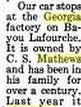
Then there was Raceland, Mathews, Napoleonville and More
Louisiana: Comprising Sketches of Parishes, Towns, Events, Institutions, and Persons, Arranged
in Cyclopedic Form (volume 3), pp. 291-292. Edited by Alcée Fortier, Lit.D. Published in 1914,
by Century Historical Association.
Mathews, Charles S., planter, Mathews P. O. or New Orleans, La., was born in West Feliciana
parish, La., May 5, 1852; son of Charles Lewis Mathews, who was born in New Orleans, and
whose father, George Mathews, was a native of Virginia, born near Staunton. He came to
Louisiana under commission of Thomas Jefferson as a judge of the Territorial Court of Orleans.
After the admission of Louisiana to the Union of States, he became a justice of the supreme court.
His father, Gen. George Mathews, of Revolutionary fame, was born near Staunton, Va., and died
at Augusta, Ga., while en route to Washington on official business. He was governor of the State
of Georgia after the Revolutionary war, and also served 2 terms as a representative from Georgia
in the national congress. The Mathews family is of Irish and Welsh origin. Charles Lewis
Mathews, father of the subject of this sketch, was married to Miss Penelope Stewart, a daughter
of T. J. Stewart, of Wilkinson county, Miss., who was a prominent man in the affairs of
Mississippi at that time, having served as a member of the state senate. The Stewart family is of
Scotch ancestry. Mr. and Mrs. Charles Lewis Mathews became the parents of 5 children, who
grew to maturity, three of whom survive at this time, and of whom Charles S. was the second
born. His boyhood days, of course, were passed at the plantation home of the family. In the
course of his education he attended the Virginia military institute, at Lexington, and after leaving
that institution returned home to assist in the management of his father's large estate, known as
the Georgia plantation, and upon which Mathews postoffice is located. This plantation,
embracing about 10,000 acres of land and affording residence and employment to about 1,300
people, has been the home of the Mathews family about 100 years. These fertile acres are
devoted to the growth of sugar cane and the conversion of that product into sugar, of which many
cars are shipped from the Georgia plantation with each recurring year. Charles S. Mathews is
now the owner of this great estate, is also vice-president of the George S. Kausler Insurance Co.,
Ltd., and has various other business connections and associations--a man of large affairs and
extensive operations. It should be stated here that Justice George Mathews, grandfather of the
subject of this sketch, was the first chief justice of the Louisiana supreme court, and a
cotemporary [sic] of Justice Hall of that time. Afterwards his associates were Judges Martin and
Porter. Judge Mathews was born in Augusta county, Ga., Sept. 21, 1774, and died at his home in
West Feliciana parish, La., in 1836.


Then there are these. If you know what I'm talking about, you know they are amazing.

Lake Charles Again


LNOT The original builders of the Slaughter to St.Francisville Extention, not shown.

MISC
1907

SAINTS SCHEDULE


Back to Burwick. I spell Berwix several different ways.


The Lawtell Dilemma. "Depot 2" is correct.

Depot 1 looked OK, but not right.

This is where my great grandfather worked.


HISTORY
This is where my father worked.
Gulf South Pipeline Company, LP
Gulf South was created in the 1930’s when five major groups, representing more than 40 power, fuel and utility companies, merged to form a holding company named the United Gas Corporation. In 1937, the corporation was restructured and condensed into three basic divisions: production, transmission and distribution. The transmission division was named United Gas Pipe Line Company. On January 19, 1940, United Gas Pipe Line became the first pipeline company to handle one billion cubic feet of natural gas in one day and on July 6, 1949, United Gas Corporation was listed on the New York Stock Exchange.
Over the years, United Gas Pipeline was acquired by a number of companies: Pennzoil (1965), MidCon Corporation (1986), LaSalle Energy Corporation (1987) and Koch Industries, Inc. (1992). In August 1993, United Gas was renamed Koch Gateway Pipeline, and in 2001, Koch contributed Koch Gateway Pipeline to a joint venture with Entergy Corporation, renaming the pipeline as Gulf South Pipeline Company. In December 2004, Loews Corporation purchased Gulf South Pipeline.
Back to Norco (now)
We have no idea why they are taking the child to the tracks.

Back to Raceland. Few know this building still exists, a remnant of bygone days on the Southern Pacific.


This was the Winn Dixie. The fella in the picture below, with the green arrow overhead, frequented it.


Yes, that's me.

Red Bluff, MS

New Iberia

The desk is inside the little building. Notice the pictures in the background.

The SP or the MP had spurs up into the industry in south New Iberia., one a lumber mill.
I would think it was the MP.


Delcombre


Erath


I&V Junction between New Iberia and Avery Island.

Mysterious for a short while.

A renowned local rail historian.

Me.

My cousin, Jolene.

Donaldsonville


This looks strangely like Mr.Martin's store. I almost thought it was mis-labelled.

The design must have been a common one or the same architect, if one.
This is Martin's Grocery, Irish Bend, Louisiana.

Notice, sadly, the wreath on the door.
Martin's Grocery was open until 10 days before Mr. Martin's death.
The added storage room was on the left, the field hand honkytonk was on the right.

The raised rook on the rear of the building was my immediate connection.
Notice the horizontal shudders on the honkytonk room. They were obviously opened in warm weather.
They were locked the rest of the time.

There was more, but I don't know if this page will open.
If pictures are missing, reboot the page.