This half cocked ride to meet a train turned into something more and for once I was fairly well prepared to attack it having been down the Bayou Sale Ridge many times. But, first, schedules and timetables in excess.
South Bend was a company spur, not a branch as it is sometimes listed. I used "company:" instead of a company name because that would only muddy the waters. The spur was also referred to as an "Extension". Southern Pacific, one of the companies, used that term for spurs and branches that were incomplete.
Maybe I should have named this overly long attempt, "The Extension".
My first attempt certainly has been extended. I've got some steam up so let's get with it. The technical stuff is first, the ride is down there a ways. Immediately we see "Bayou Sale to South Bend" listed as a "branch". Possibly a company in the lineage had. Nevertheless, the date is useful as are the others.
Update. Of Important Note:The 1937 map shows the SP / ML&T / TN&O rails all the way to South Bend.In 1941, the whole line was abandoned.
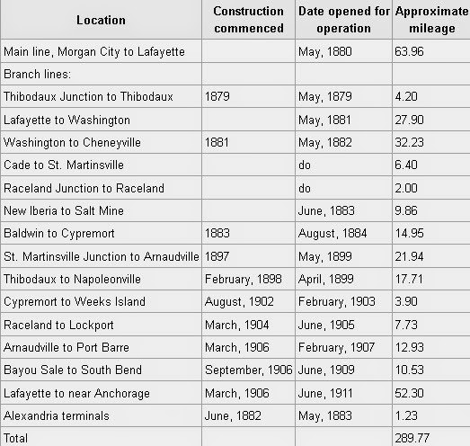
It took 3 years to complete the 11 miles and there was no Intracoastal Canal at that time. I wonder what the problem was. The land is high enough. Money? Yet another listing below.
South Bend was a company spur, not a branch as it is sometimes listed. I used "company:" instead of a company name because that would only muddy the waters. The spur was also referred to as an "Extension". Southern Pacific, one of the companies, used that term for spurs and branches that were incomplete.
Maybe I should have named this overly long attempt, "The Extension".
My first attempt certainly has been extended. I've got some steam up so let's get with it. The technical stuff is first, the ride is down there a ways. Immediately we see "Bayou Sale to South Bend" listed as a "branch". Possibly a company in the lineage had. Nevertheless, the date is useful as are the others.
Update. Of Important Note:The 1937 map shows the SP / ML&T / TN&O rails all the way to South Bend.In 1941, the whole line was abandoned.
It took 3 years to complete the 11 miles and there was no Intracoastal Canal at that time. I wonder what the problem was. The land is high enough. Money? Yet another listing below.
Morgan's didn't list it and they built it.

Below you see where the 1907 Gazette refers to two "extensions". The exact location of the settlement of Bayou Sale is a little shaky. I may dive into that later. I think we can assume it was just south of the Texas & New Orleans (Southern Pacific) main line. Hang on. I know this is tedious. Adventure is ahead.


1908, "11 miles, grading is finished". Here's yet another list.

Here conditions are applied to the spur. You can see that South Bend is not included in the "Branches". I don't have a date on this warning. It does show that the Port Barre Subdivision and the South Bend Spur were not "up to par".

South Bend was a sugarcane spur as described in the "products" list. Possibly the shortened route to The Canal just wasn't profitable enough to fix the rails and that is why it was abandoned. The sidings or spurs on the S.Bend spur coincided with the plantations. This was found on the 1935 SP timetable. I finally found South Bend listed in "NOT OTHERWESE SHOWN ..." It was a snake that could have bitten me. Seems it did.
.jpg)
Some timetables included a station at the Bayou Sale spur head, some didn't. In 1915, the new spur did not rate a place on the timetable. This is probably because Bayou Sale was a loosely organized area of plantations. "Loosely" was used on purpose. I found that either land ownership record keeping or surveying was not an art form down on the bayou. I know I read that somewhere. There was a post office just south of the Southern Pacific mainline on La.317 which I believe at the time was numbered La.60. I believe it was the official site of Bayou Sale's mile post zero. according to the railroad. A friend's wife's relative was postmaster. He lives in what was a railroad section house. 1915 ... No Bayou Sale Maybe was in "Not Otherwise Shown ..." and I missed it.

The 1926 version did list a depot at Bayou Sale. Possibly one was forced on the railroad by the commission. Or, there was no need for one in the beginning.as the gentry of the area seemed to gravitate to Franklin's depot or Centerville where the Missouri Pacific had a station. ML&T, 1926 Bayou Sale is listed.

1935's version listed the depot. "To- R" is a an interesting notation. I'll have to check w/ my experts on that, again. I was told but I forgot.

Below is after the South Bend Spur was severed. There had been a rail bridge at what is called "North Bend", named after the plantation there. I surmise that when SP decided that hauling cane was not profitable enough to maintain the bridge and rails south of the Intracoastal Waterway they amputated the line south of the canal. There may have been other factors including regulations or size of the canal. Possibly a hurricane was a factor? The "cause" is not covered here as too much is already. Below, the South Bend Spur has been changed to North Bend.but doesn't have "(spur)" next to it. Very confusing for a beady eyed researcher. Nevertheless, North Bend was never a branch of the Southern Pacific or priors. Have I made my point? That was scary obsessive. I may need therapy. Today, the Louisiana & Delta may call it a "branch". Ah, but look at the bottom of this list, the writer save his britches by saying it was on a "spur".

I got out my ruler. North Bend was a plantation. Cabot is the location of the carbon black plant. The measurement came to 4.5 miles. Bayou Sale is seen on Garmin's map as above the railroad. That means nothing as Garmin is not trustworthy. He's my other brother-in-law. I'm remembering now that the new L&D North Bend route may not be the same as the route north of the canal in the previous South Bend configuration. I don't have time to overlay the tracks. I think Agent OO-L, renowned expert, discovered that. This write will concentrate on the railroad's route south of the canal. Back stoke: "North Bend was a plantation".

More stuff of extreme interest to follow and then the pictures. The Intracoastal Canal split the plantation. The cemetery is on the canal's south side. A notation from a Corps of Engineers article.

"data recovery" or "bones and fragments" So, like when the Morganza Spillway was built, possibly graves were moved. This notation started the nagging about "did you see the North Bend Cemetery?" I'm repeating this prop for the names, their order and the distances. I may need it again. I rode the "rails" and the mileage is important
to me.
I started gathering names.
I wanted to see how many of the road names
and stops on the railroad matched the personalities.
Todd was about my only really big hit.
There, of course are others, nevertheless, many
seem to revolve around the Todd Family.
On the map above you can see "Todd" as a location.
Todd, actually 2 Todds were the owners of Ellerslie, the "big plantation".
Its "big house" is still there and it is lovely.
It is not of the Greek Revival architecture but more like a large townhouse.
This obit started my search.


So here's the tally so far. Todd owned, in partnership with Hernsheim and Wright, Ellerslie, South Bend and Tidal Wave Plantations. That is important because where the rails end was his property. More names to match.

Schwan was owner of Germania Plantaon on Bayou Sale. Bayou Sale is on the east side of La.317. John R. Todd was in court. What for? Intrigue on the bayou? Swenson, "of North Bend" was "up". Up from where to where? Swenson may have been the original owner from who Todd bought North Bend. Ditch that. Below, the name "Clausen" is seen. It is also seen on the map and the spur listing. I would visit them all. Going down the line I'd come to roads that left the rails perpendicularly, crossed the little bayou and met the highway. They, of course, serve as access routes to the fields but I think they were more.

Possibly Todd had hired Mentz to represent him "in court"? Clausen will be an important landmark on down the line. I do believe I identified his home. Also seen is "Maryland", a place on La.317 (map above) The map below displays so much. The names are there. The lay of the land is there. And, a hint of what is to come on this adventure is there.

Check the names. Ah, so this is getting interesting! Just wait.
James Todd was probably a relative of John's.

Poor James. Was he singing the blues? I'm so down "ordinary" looks like up to me? Glad he had friends. So, "The Garret Place" was another one.

JR. is seen below managing, but not owning Ellerslie. It was owned by his brother at that time.

Now, don't you feel immersed into bayou society? Here's a little history done in 1952.


More scraps of paper. This is from 1900 to 1910. You can check the above build dates to date these reports.

More Props Here are some old pictures collected which were labelled "Bayou Sale". This is an oil field company camp. United Gas and Standard Oil were prevalent on the bayou. I remember my father, a Union Producing company employee (the drilling arm of United Gas, the pipeline company) telling me he had to go to Bayou "Sally". The name of course stuck since it was a "girl's name" and we had a Sally Fox as a neighbor and the song "Sally Was a Good Old Girl" was being played on the radio. That was about 1962. Humble Oil Company camp.


This is as close as I came to finding a picture of the Intracoastal combo car and rail bridge at North Bend.

From being there I can identify that this picture was taken after the bridge was gone.

This is approaching the bridge. I made that up. But can't you see it down there?

How about now?

So, what is that below? It's archeology, dear. This is the proof that the bridge was a "combo". It is the asphalted approach seen below.

Here we go. I was not interested in the area above the canal. It seemed modern as it still has a functioning RR. I wanted to track the tracks, my real hobby. Tracking existing tracks is OK, but it's cheating. Plus, it's not really an accomplishment. I crossed the new Intracoastal Canal Bridge at North Bend and swung around for this north shot. It says so much. I'm looking straight up the "tracks" to the rail & car bridge where the asphalt was found. The highway went to a later bridge. I would go to the water to see what I could see.

The red line was the rails. You can see where the old highway bridge was.

The Bayou Sale Tracking the Tracks Ride
Or should it be the "Did you Find the Cemetery Ride?
Let me tell you something and I'm serious. I've been posting pictures of cemeteries for15 years and no one has ever commented. I miss one damn cemetery and a gaggle wants to know, "Did you find the cemetery"?'
No. And there are no cemeteries in this write.
I gave up a while back since I thought they were too morbid for my believed "sissy readers"
and now I see these same readers as master ghouls who only reveal themselves when denied.
I think I'll leave that adventure to others.
Though bland and mundane, this is about mine. Go find a cemetery if you have to.
My outing begins:
It was a beautiful day.
I had no excuse and I knew the Sunset Limited was barreling up from New Orleans
It was 15 minutes late which might give me a chance to meet it at Franklin or the Bayou Sale passing track.
At Franklin I went to the location of the old depot but the place makes me nervous. Shootings do that.
So, I left and came back and no train.
I figured it was late.

Download Time Please keep the "Bertberry 1" signature. The man, Bert Berry, was a great photographer and collector of postcards.

Looking south at Franklin.

Looking southeast. Obviously, the depot was located on a "point".

Since I hadn't heard it and I even asked a Post Lady if she'd heard it, I pushed on to
Bayou Sale. I'd missed it.
Though this place is more "Garden City" than Bayou Sale, still "Bayou Sale" is what BNSF RR
calls this passing track which spans from La.317, which is where the post office was,
to the US 90 overpass which is below the residential area of Garden City.

No train but I did check out an old "Private Crossing" to nowhere, I thought.
I can't tell you how tempted I was but hauling the sign home might have garnered suspicion .

There is a cane road down there. It may have been more than that in the past.
Indeed it was.

Little Hints should not be passed up. Dig Deeper! Below, you see the Crossing where the above picture was taken. The cane road is in red. US 90 severed it.

At the north end, near Bayou Teche, I found this.

On the map above you can see how close this house is to Garden City. It is built in the exact architecture as the business offices of the Hanson Lumber Company. By the way, that building is pictured in the movie "Easy Rider". There is, of course, a connection with Garden City. A continuation of that road went south to the swamp. Hanson was cypress mill. Put 2 & 2 together and you get what 4.

Back to the crossing:
I shot east in hopes of catching the on coming Amtrak speedster. *Of note: Do not stand on or too close to the tracks when shooting "speedsters". Don't stand on the tracks, period or you'll be like mama and get run over by a "damn ol' train".

A cop came by so I shot the drainage ditch.
I'd feign being a "pictures of drainage ditches collector" if interrogated..
Anything is easier to explain than "railroad nut".

I swung on around to Log Bayou Rd. where the hot box detector is.
This is a good place to take Amtrak pictures.
If you have a scanner then you can listen to the little guy in the metal box tell you
if the train's wheels are too hot and how many there are of them .
He never comes out but I still yell "hi" when there.
Union Pacific has ladies in their boxes.
They even give weather reports. I guess they come outside? I've never seen one of them either but being a judge of voices I'd say they were cute.

I guess his wife dropped him off. I didn't see his truck there.

I gave up which left me 60 miles from home with nothing to do.
Then I remembered the unfinished South Bend RR Bridge mystery.
Had it been a combo bridge, one that served the highway and trains?
I moved slowly down La. 317 toward the Intracoastal Canal.
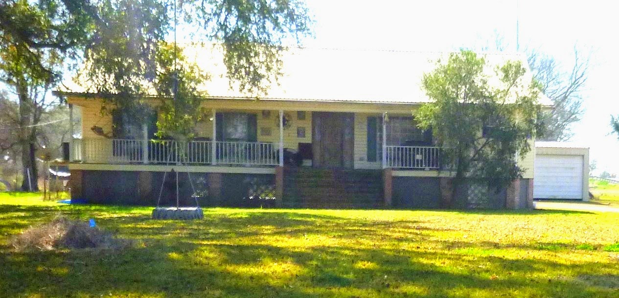
I still take pictures of old houses.
With each passing year thousands of look alike brick ranch homes are built. By comparison, these relics
of the past and the care that they reflect shine even brighter.

Just for reference, this fine old house is at Balco, a stop on the South Bend Spur.

Still above The Canal, I crossed the present North Bend tracks. The rails from the now BNSF main line are called North Bend. When the tracks continued below The Canal, the spur was called South Bend because that place was its destination. Edit note: That was kinda simple sounding. In the picture below it is easy to see how the ground is slanting to the Gulf.
This is the first rail crossing.

GE Map.

I had arrived at the "Palm Houses" as I have named them. There is or was a large palm tree on the farm equipment side of the road. The houses are located at the location of Clausen on brother-in-law's map.. Now you see the importance of "name research". "The Palm Houses are now Clausen. They have always been, but not to me.

House 1


House 2, what I believe to be Clausen's home. Note the chimneys. It is old.

Below is a place location picture. I take them to keep track. (lols) "Garden City Field".

L&L Yokeley Plantation was next. I'd been here before. The old building / cabin is a landmark.

These are serious farmers.

But, I think the Yokeley's are newcomers, though I see the name in Franklin. If you see the name in Franklin, it's old.. This is the location of Todd, a name with which we are familiar. Was this the beginning of the North Bend Plantation?

I do think so. Here came the second crossing which is right above Cabot.

Approaching Cabot & Columbia Plants This is the location of Johnson. I made this map larger to show how this sliver of land sits in a sea of marsh. The plantations could not be that large. The black line is the L&D RR line.

The Canal Bridge lay ahead. There the fun would begin.

First a few shots of the Cabot location.


Crossing the Canal

I'll insert these maps.
This is from Belle Isle 1941. The line was abandoned.
Note that "Clausen" is set near the rails and not on the highway.
Maps? You never know where "space to print" comes into effect.

Note in the above map the highway no longer took the rail bridge (was it gone?) but looped around to the east and crossed The Canal on a new bridge. I had wondered how a swing rail bridge and a swing car bridge could be so close. I think they never were. This stuff is important in certain circles. Possibly not yours. "Bridge South?" should not have a question mark. That came from a confusing Corps of Engineer's report. The North Bend Cemetery location was located but not by me.

"Rosebut" is a misprint. I don't know where my head was.. Moving South. The names come from other maps and what I observed. There are street names, objects and location names. "Bessie" was not the gal up on Cripple Creek.

There's Ellerslie.

Here's the 1937 Version before the abandonment. I could not find a pre-1941 Bell Isle which would have been my guide. I winged it and may have been wrong but I don't think so. I just noticed the green section crossing the rails. I found that but no trestle.

The red line is how I envisioned the rail route.

Here is the exciting end of the rails at what I believe was the Todd Plantation aka, North Bend South.

Now the ride. This is the aforementioned and pictured alley to the rail bridge.

Heading down it.

The asphalt.

Looking across The Canal.


Oh my goodness. There's the abutment for the swing bridge.

There were pilings on the south side.

There is nothing like being 100% right and void of embarrassment. Apply this scene to the old picture way up above. That picture was taken long after 1941 when the rails were abandoned and the bridge was gone. Troubling is that there was no new bridge in that picture.Someone would have mentioned it so I'm saying it now.

This is looking south from the bridge location. Yes, the trail continued on the other side of the road. I was going to do it. There had been no rain for a week and I'd chance it on the heavy road bike. If it starts going sideways the ground is the next depot. At least there would be no witnesses.

Garmin's map confirmed the road / rail relationship. I'd be right on the old right of way, at first, for sure.

Here we go.


I love it when power / telephone lines are with me. They followed railroads. The bayou is to the right which is west.

Second access to highway. Map below. This is ooking west from ROW

I figure I was at the location of Midway at the Third Access.

The track stretched out before me. I am so glad this was in winter. It would be an alley in the sugarcane otherwise and probably not alone.

Third access to highway at Midway.
Was Midway a plantation name?

"Black Tank" on map.

This white stuff is deceptive.Possibly it was only dry on top and siting in a sea of black grease. If so, I'd be sunk.
I reflected on my judgement.


Ahead was the low place. I decided to leave the ROW and not chance it. That is where a trestle would have been. I'd visit it later from a good road on the other side.

I left the rails and headed to the highway. I felt like I'd chickened out. I wish I'd chickened out on previous misadventures.

I was right above Ellerslie. That was a strategic chickening.

Bayou Sale is a beautiful lowland.


A small house was across the highway from the exit road.

I went back to the crossing. The greens were fluorescent.


This place was gorgeous and a picture of the little house through the woods had to be tried. Yes, it could be a painting.


Another one was near. It is what I call "The Antenna Location".

I'd pop my head in at Bellview-Front. Bellview? Wasn't there a Bellview Plantation?

This what the map calls :"Ford Industrial". It was not the right of way. I could have proceeded farther in and found it. I felt a voice telling me not to. Possibly a chicken's voice. Looking north on Ford Industrial

Looking South.

Looking south east on the road that would have taken me to the Right of Way and the chicken said not to. I regret that now Mr. Chicken.

I was at the Bayou Sale Store, visited long ago. This time the visit would do it justice.


These are several pictures taken from that long ago visit.
.jpg)

This time I'd walk inside. The floor was bad. The shelves were still in place. I summed it up as a home and store.
.jpg)
Back bedroom.
.jpg)
With facilities.
.jpg)
This kitchen probably served the store and home.
.jpg)
.jpg)
Extended kitchen in back.
.jpg)
This was someones home.
.jpg)
Now here is something interesting. At Irish Bend there was a jukejoint next to the store. Did this store have one, too? Why didn't I get a better shot inside it? I know it did.
.jpg)
It had an outside door.
.jpg)
I left and went down to Exxon 1 Lane. Pipeline stuff could be seen within.

Looking north. That is not the right of way.

I need to reboot with a map. "Hospital Rd."? Street names in old places are the key.

Martin Ln. on the map should read Marin Ln. Looking south from Exxon 1.

I zoomed way down and did not want to go there. It seemed to dead end.

Back out on the road I came to Marin Lane. (not Martin).
This is where the tracks had curled to the west probably at a cane loading site.

I will bet their driveway was the rail bed.

Across the road the rails continue. I am illusional. In my mind, and possibly in reality, I was there, the end of the line.

Zooming out on my map I was shocked. Big Oil has raped the marsh just as Big Lumber raped the forest and marsh.

I decided to ride south to Gordy where I had been in 2010. Captain Gordy had been Captain Cornay's second.
That is why I had come here before.


A cane road continued south. Was it an extension? LOLs.

The levee lay ahead. This is as far south as the Bayou Sale Ridge could support dry land agriculture.

This house was at Gordy. I don't think it was the Captain's.
I headed north. Place marker, Exxon Lane.
.jpg)
Brief descriptions will follow. An open section of the bayou.
.jpg)
.jpg)
.jpg)
A pipeline shack.
.jpg)
This is probably where the Exxon company camp was.
.jpg)
Board roads and platforms, preparations for drilling.
.jpg)
Up ahead is where the rails ended.
.jpg)
I was back at Marin Lane.
.jpg)
But, there was one more place I wanted to see on the Right of Way. That was where the trestle had crossed the coulee, the low green place on the topo map. I rode down the road. I now realize I did not have to go far because the rails were close to the road here, just on the other side of the bayou.
.jpg)
I think I was looking at them going south.
.jpg)
Oh yea, this is looking north. There was alignment.
.jpg)
I was very proud of her for finding that.
.jpg)
Ellerslie Road.
.jpg)
And back across the bridge. I had to see where the railroad bridge had landed on the north side so I took the loop that the highway had.
.jpg)
.jpg)
.jpg)
I stood on the bed while yard men buzzed around with weed eaters wondering what I was doing.
.jpg)
I ventured to the end and looked down the alley where I'd been hours before.
.jpg)
That is where the old car bridge had been.
.jpg)
.jpg)
I stopped at the Hanson Canal and remembered my adventure there.
.jpg)
I caught L&D headed to Bayou Sale.
.jpg)
I shot my favorite plantation.
.jpg)
Saw some guys working on the railroad.
.jpg)
And had a very sad moment. LZ, the white old house on the crest of the bluff on Lady of the Lake is gone.
.jpg)
I almost got emotional. As in so many, only the chimney remains. I have to find my picture of it. Together with the barn, they were so beautiful.
.jpg)
I got my first shot of the offices (old commissary) at St. John without a dumpster in the picture.
.jpg)
And a few of the old houses there.
.jpg)
.jpg)
And, the old plantation church.
.jpg)
I'm glad this one is over, but I had to finish it. Amen.