Update: More will be added to this page soon. {8-24-2013}
This is a multi-article page dealing with long gone rails that went from Lafayette to Cheneyville, Louisiana.
First: The Hub City
It started while I contemplated how I was going to ride the
Sunset Limited or maybe chase it. It seems to me that on
Friday you can leave Lafayette at 10:15. Get off at Schriever
and wait until 1:25 where the west bound will pick you up
and bring you back to Lafayette for 1:45. Now, here's the
problem, the east bound is coming from Los Angeles. Given
the uncertainty that can occur, actually arriving at Schriever
in time to catch the fresh train coming from New Orleans, may
be a crap shoot with terrible odds. Sitting in Schiever with
nothing to do and nowhere to go, you might want to get sedated.
I know a bar there with a "floor show", a lovely place.

Not being Friday I decided to go to Lafayette anyway. This is the history that drew me there.
Lafayette was geographically and geologically in the right place at the right time. The Southern Pacific Railroad built an expensive speculative rail line across some very difficult terrain, the untamed Atchafalaya Basin, to connect Lafayette with the population centers along the Mississippi River, the next dependably high ground going east. Another line came from the New Orleans area through Lafayette to reach Opelousas and eventually Alexandria. Another linked Texas with Lafayette. Lafayette was a transportation center. Here are a few old schedules.
Southern Pacific, to the north, Lafayette to Alexandria 1915.

1926

M.L.&T. = Morgan's Louisiana and Texas RR. = the SP, later.
Lafayette to Baton Rouge, the mentioned Basin Route, the east route.
1926, one year before the demise of the Atchafalaya River
bridge at the settlement of Atchafalaya, site of the Welcome Center
on I-10.

To Morgan City 1935, the southeast route '
eventually to New Orleans. (Click to Enlarge)

And to the west (1935). Click to read.

I knew where all of these rails converged but was very confused on how it was done. That confusion is born from my 2 different maps, one old and one new. It was 96F and the humidity was riding the wave of a couple of weeks of rain, weather perfect for stop and go urban warfare in the carbon monoxide and killer traffic. Remember, I'm on a motorcycle, the only way to do this properly.
Old, probably in the mid-1970's. (Garmin GPS)

Present day arrangement (Garmin GPS):

Combining the two, I came up with this. Click for the full size version.

And from above. I have drawn in what I see from ground
evidence.

What seems pretty close are the rails coming in from the
west (red), and the rails going to Breaux Bridge (green)
though there have been tweaks. There once was a double
set of rails coming in from the west.
The connector between the west rails and the north rails
are strangely different when looking at the Garmin and
the present reality on the ground today. Sometimes
approximations are the best you can do.
The problem with all of this is that I didn't study the maps
until I tried to figure out where I took the pictures. This
approach always requires a second trip to fill in the blanks
and to verify assumptions. Further, you can't trust Garmin.
Exact railroad interpretations are not their business.
The trip will begin on the next page, to be done later.
I decided to put the next page here since getting anyone to
actually click to the next page, after this page, would have issues.
I ventured into Lafayette to the living rail museum which
is the Cameron / Mud Street, Washington St/ N.Pierce St,
and Buchanan St. area. My first set of pictures were taken
from Cameron Street where you see the red arrow. Some
may say this is the arm pit of Lafayette. I may agree on
some levels, but for investigating rail history, it is a gold mine.

The Legend: (no not me this time, the map's)
Green: The Baton Rouge Branch, aka the Basin Branch.
These rails now end at Breaux Bridge.
Orange: BR (Baton Rouge Junction)
Blue: N.Pierce and the existing UP/BNSF crossing.
Yellow: The historic cross track of the BR rails and the
Alexandria Branch of the Southern Pacific.
Yellow Line: The SP to Alexandria.
Yellow Arrow facing down points to the location of the
present depot.
Yes, again, below are maps of the Cameron Street Crossing area.
The red arrows are the Baton Rouge Branch, still active,
and the green arrows point to Cameron / Mud Streets.
The road is named "Cameron on the west side of the tracks
and "Mud" on the east. It's Lafayette, go figure. As a local
teacher once told me, "The place was designed by cows".
It was also diced up by the railroads and highways as
pronounced by some thesis done at USL/ UL, what the hell.
1978

This is how it is now (2010 for those calendar challenged
as I am whenever I write a check).

Here's an explanation:
Remember, I was standing at the red arrow on the top map.
I shot across Mud (east side of the main line) . The disappearing
rails are the Southern Pacific remains going to Alexandria (the
"Alex Jct" we'll see it on a sign later) and either a connector to the
Baton Rouge Branch (to be investigated Monday) or a spur
to a business seen in the background. Sunday would not be
a good day unless early and I don't do "early".
.jpg)
Panning right (east), you can see the rails headed off to
Breaux Bridge on the old Baton Rouge Branch.
.jpg)
Backing up and panning right, I got the historic and now
unneeded crossing sign for the ripped up Southern Pacific
Alexandria Branch. That's Bragg Street and Mud Ave.
.jpg)
Panning right again, south, off in the distance you can see
the new depot. The old one was the the target of an arsonist,
I think I remember. Nevertheless, it burned down.
.jpg)
Panning right, timing? Actually the train would appear a
little later and we'll chase it to the underpass. I need to
give you something to anticipate.
.jpg)
To view page one of this epic, CLICK HERE.
After last night's awesome visitor numbers, I am renewed
to continue with this episode. From the Cameron and Bragg
location, I crossed the tracks moving west. First the
abandoned Southern Pacific ones and then the live BNSF ones,
making a north turn onto N.Pierce St. I came to the live
rails and took a right along the tracks on what I don't think
was a road. I stopped directly across from the switch to
the Baton Rouge (now Breaux Bridge) Branch.

Railroading seems to hang onto historic labeling. "BR"
is for "Baton Rouge".

Yep.
.jpg)
Those are the rails just above "A" in "Ambulance" on the map above.
They are the ones seen from Cameron St. I don't want anyone
getting lost. What's that on my elbow? I'll be back there today,
Monday, if I don't snooze off from being up at 2:45 AM and
writing up this junk.
I then went back to N.Pierce, took a right, crossed the live rails
where I had turned before and went to the second hump that had rails
on it. I'll be back because I didn't shoot both ways, duh, but there
was traffic and I was nervous being in such a wealth of historical
information all at once.
After crossing the main line I came to a second set of rails.
I say set because there were two. One may have been
to a spur. The other, I feel sure, was the old approach
from the west rails to the north rails or from Lake Charles
to the abandoned ones going to Alexandria. A jaw dropper
is coming up.

There they go bending north.
.jpg)
I next continued up N. Pierce and cut over to Buchanan.
I stopped there and parked in a driveway to a field which
lay along the tracks.

I shot this picture looking south back to the point of the
picture above the map. I had to park where you see the
"L" in Lafayette. The bike is at the yellow turn arrow in
the corner. This is the "End of Rails" point seen in a
previous map. From this point north, only the bed is
evidence all the way to Cheneyville. There had been
two sets of rails from the crossing, making the curve
to this point, maybe. It'll be on my "2du" list for today.
.jpg)
A man approached my bike on his tractor.

I ran back to the bike thinking he might need to get out of
his gate. He stopped and I asked him if he knew where the
roundhouse had been. He explained that he thought it was
off the Evangeline Thruway. That's all I could think to say
to him, at first. Then I asked if rail traffic still came up this way.
He said, "No, but could you help me fix my tractor"?
I agreed to and we spent the rest of the day and half the
next fixing his tractor. Then he asked me if I'd like to
sit on his front porch and rock a while. I told him thank you,
but I must be getting on with the rail hunt. He told me
to "take care" and for the rest of the ride, I did, making
sure to have no more personal contact.
Very sleepily I went down Buchanan, crossing the Baton
Rouge Branch, turned west on Cameron, crossed the old
Southern Pacific branch to Alexandria and then the live
rails to New Orleans and Lake Charles. I got off Cameron
onto Hopkins and then turned north on Washington where
I recrossed the live rails and then came to the Southern
Pacific connector that I'd been with on Buchanan. I was
starting to get the idea. I turned right on this dead end
street (now). and stopped, slack jawed.

I was slack jawed because I saw this. It, like the old I&V
Junction sign down in Vermillion Parish is a relic from the
past, just as the BR (Baton Rouge) sign is that you can see
at the end of the red arrow in the background. I had discovered
the Holly Grail of Lafayette Railroad History. I am still
slack jawed and shaking from the experience.

Just as I was getting ready to start a new leg of the hunt, I heard the whistle blow. I flew back to Cameron Street facing west as 3 big engines pulled around the west to south big bend and headed south. The next sequence is page 3. I'll give you time to catch your breath before I hit you with more history. And, I haven't made it back to Lafayette to fill in page 2. But, my yard's mowed and the wife is smiling.
Back at Cameron/Mudd Sts.
.jpg)
Same
.jpg)
Same
.jpg)
Same, showing the Alexandria Branch tracks crossing
Mudd on the way to parallel the siding for the depot. The
train would merge with the Alexandria Branch to continue
south, or, head into the station siding.
.jpg)
This is the 3rd Street crossing. It was the first road
crossing north of the station. There was no Jefferson St.
Crossing.
.jpg)
Same
.jpg)
Approaching the depot and getting ready to cross the
Jefferson St. underpass.
.jpg)
Being a frivolous page, I simply traced a line down the
map where the chase occurred. I dropped down Buchanan and did
a jag onto N. Grant St., continuing until stopped by the under-
pass on Jefferson and shot the depot with the train coming by.
Writing this up, I decided to switch the maps over to the older version
and I've discovered a few things.
At first, this is all I was going to show you. This is the new map with
my run down Buchanan and Grant to Jefferson.

Do you see where N.Buchanan changes or rather meets N.Grant?
That is E.Simcoe seen in the map above.
On the new map Buchanan does not cross the tracks
until it uses the Simcoe crossing, seen below.

I get a little repetitious below. It's like I'm trying
to convince myself. I once loved maps, no more.
On the old map, below, Buchanan dives across the two sets of
tracks. There was no east road next to the tracks past
where it crossed until E. Simcoe where North Grant started
shadowing the rails. Notice the jag in N. Grant where
it crossed the siding rails and then it got closer to rails
one block above where it turned hard east. The old map does
not name the streets so I can't tell you whether the turn
was Jefferson St. or not. Nevertheless, the Jefferson St.
underpass was not yet a reality. The station would be
at the end of the siding on the left of then the main line.
(west rails)

On the new map, N.Buchanan drops south but
does not cross the one set of rails until it uses
the E. Simcoe crossing to do so, then it continues
south as S. Buchanan. Grant Street follows the
rails in an even drop with no waver since the
east siding is no longer there. It is my belief that
when the east set of rails, the ones that fed the
Alexandria Branch, were removed, the city used
some of that space to continue N. Buchanan south
and to straighten out N.Grant all the way to the
the Jefferson Street underpass where the
yellow mark is. That was where I had to stop the
train chase.
Now, the active rails, if the GPS is right, occupy
the old western siding which had dead ended at the depot,
just past Third Street on the old map. The crossing
north of the depot had been 3rd St. where there is still
one. I'm sure there are other differences but I'm burned
on this page which I thought would be a "pass".
Have you seen this one, yet? It's a new version.
Say you have and let's move on.
By the way, the next crossing south of the station
was Johnston Street, a wait then and a wait now.

I hate to write stuff up when I don't have all the facts, but, if I don't write it up quickly after the ride, I will lose interest or I'll just send it off in an easy, got her done, email. I can save those as easily as I can save a web page so on my end it makes no difference. But, I'd rather share them with the world than with just the winos, prostitutes, organized crime members, crooked cops, and pimps on my mailing list. You're shocked? It's Al's fault. Those are his friends ever since he became Lt. Dave Robicheaux of the Iberia Sheriff's Dept.
Below you see the yellow lines. They are my trail on the 8th.
What I've added are points where I should take a second look. I want
to verify Garmin's 2 rail approach from the west. I know Bump 2
is there. 3, 4, 5, 6, will have to be checked. I also want to gps the
existing rails which might mean riding them on the bike. I've looked
for a train schedule and can't find one so I guess I'll just wing it.
The angled road above the tracks has a purpose. What was in
that space between the tracks and the next road up, Anne St.
Bump 5 and 6 are in the left portion of that area.

At Bump 3 was this, a beautiful building owned by some
"produce supply" company. I love corrugated steel. I can't
say for certain that it is at Bump 3. It might be between
Bump 3 and Bump 4? That has to be determined. Don't
ask me why.
.jpg)
At bump 4, or near, there was a bump equally high with no
rails on it.
Looking to the west this was the scene. That's the St. Anne
field. Look at the map and follow a line along St. Anne over to
the branch going to Breaux Bridge and once Baton Rouge.
Did the SP just skip all that Lafayette jazz and head east?
The streets seem to say so. One even jags to accommodate
a 90 degree crossing.
.jpg)

Alas, as I've said, this is all speculative with no actual reference
points marked.
NO, this is verified.
After checking out Anne's Field, I made the block back to the rails.
This area is not on the Cleanliest City Award tour route and I did
not stop until I reached Huval Street. I guess everyone was amazed
to see a blue bike on these streets. I guess they don't like blue.
For some reason I made another block and came back to Walker Road,
the location of what is called West Yard on the old schedules I showed
you on page one. (BTW, those were courtesy of Everett Lueck andI'll
have to send him 50c each for them or plug the Southern Forest Heritage
Museum at Glenmora/Longleaf, yet one more time).
Below is the old map's interpretation.


This is from outer space: It's large if you want to click it.
What it shows is the Walker Rd Lafayette Power Plant
across the road. There is a spur that at one time, not long
ago, appeared active. I'm not sure how far back it went.
I can only speculate what it delivered or hauled off.

Here's what I saw there:
.jpg)
.jpg)
They did not cross the road, but had not long ago.
Here's the yard. I'm pressed for time so take the self-
guided tour.
.jpg)
.jpg)
.jpg)
.jpg)
.jpg)
.jpg)
.jpg)
.jpg)
.jpg)
I proceeded on until I found the spur that went up into the
back of my favorite, Southwest Scrap and Salvage. I actually
sold something there.
.jpg)
.jpg)
.jpg)
.jpg)
The Railroad Museum area of Lafayette is not really the armpit
of town, Scott Road is. It is as nasty industrial as it gets.
It is layered in refuse from a number of oil booms and busts
plus the other industries such as the scrap yards and car
junk yards, you get the picture. It even had a roach infested
bakery where I once worked. The railroad fits well there.
The ugly keep the economy going, rose gardens don't.
I'm calling this one off as I'm tired of it. Hope you got some-
thing from it. More later.
.jpg)
I turned north at Scott to head to Opelousas where
I hit some more tracks. Them later. They are in the
Yellow Choo Choos read. To continue hunting in downtown
Lafayette, CLICK HERE.
.jpg)
I walked out of the house this afternoon about one o'clock expecting the heat and humidity to knock me down. Not so. It may have only been 80F. I knew there must be rain near but I didn't see any action aloft that might keep me home. For those that are questioning my first appearance outside at such a late hour, I was vacuuming. You got any problem with that?
I decided that while I still had the boiler stoked on the Lafayette Hunt, I better get it done, and why not on such a mild afternoon. I headed back to the great cross roads of Lafayette railroading, the Cameraon Street / Mudd Avenue juncture. The GE map below is pretty large. I suggest you click on it and open it in a new window, set it to the side and refer to it as I try to share my excitement. If you are not railroad inclined, go watch Beck, O'Reilly or Hannity. You will fare better and learn more but they may put you in a bad mood. We need to be in a bad mood.
I don't think you'll have to expand these after all.
The one below is the old map ware again. To
review, Southern Pacific came in from the west. The rails
are still alive with only one set now which bends
south to New Iberia and New Orleans. The line coming
from the north was also a SP Branch going to Alexandria
by way of Cheneyville. The rails to the east are the
Baton Rouge Branch going there by way of the Atchafalaya
swamp and the Missouri Pacific ferry at Anchorage. I'm
not getting into the present and who is doing what with
what's left over from the past. This page will be only a few
pictures of what I found on the ground and had to explain
to a cop. By the way, the best way to make a cop lose interest
in you is to start talking old train history. He wanted to
leave so badly I felt sorry for him but did not let up until
I told him everything I knew about everything I knew.
Actually, that was a story. The cop stopped to check out
my bike since I was not around and it was parked where
normal people don't park. I told him I appreciated it
because it might be my bike that was stolen and he found
it. He asked what I meant by "it might be my bike".
I told him it was my bike and it wasn't stolen but it might be.
He asked why did I think it might be. I told him that it
might be because of where I parked it except that public
heroes such as himself were checking on it. We all grinned
knowing there wasn't much more to be said on the subject
and the BS was about hubcap height and rising. His next
step would be to book me for impersonating an owner
of a stolen motorcycle.
After that, he did leave. Have you left yet? I like to weed
out the less than serious.

This one you may want to expand in a new window.
I continued the hunt at "2X". "B1" is where I parked
my bike and talked to the policeman. You can't find it, can
you? You have to right click it and choose open in a new
window.

I'm so afraid this is getting tedious. To help liven up the
pictures, I've added arrows. I want this to be completely
clear when you go by to visit. BTW, there's a real nice
lady that runs an aluminum can salvage business right where
I parked. She also turned me in to the cop when he asked her
about the bike so don't start nothing or she'll bust ya.
This is where the bike was parked. (B1)
That's Mudd Ave. behind it. I figured it was a good
place to park. Sure was a lot of limestone around.
Yep, I was in the sweet spot of Lafayette Railroading.
.jpg)
We'll go to the other side of Mudd to get you oriented.
I originally thought that I had found some very important
branch of the Southern Pacific, and it still may be, but I
don't think so. The arrow pointing straight across the
road marks the SP on its way to Alexandria. The arrow
pointing at the building is suppose to be pointing at the rails
veering off to the left to only businesses on N. Pierce, I think.
It is the very hard to see purple line on the Earth Page. The
arrow pointing straight down is pointing at the screened
building. It will become very important in your orientation.
If you don't open that map you'll be lost.
.jpg)
Below:
Crossing the road and looking back across the street, you
see this. Straight down line is the SP going south.
Slanted line is the business spur. Not seen is the screened
building.
.jpg)
Turning back around and looking north you see this.
This is where the Alexandria Branch gets ready to cross
The Baton Rouge Branch going north. The screened building
to the left separates the SP from the spur. The other arrow
points to a boxcar. It is at Mike Baker Brick on N.Buchanan.
We'll go by there when we clear this area. Remember it.
.jpg)
Emerging from the grass are the SP rails. I'd hoped to
find the actual cross track in the grass but it was gone.
Unfortunately, this is the less spectacular of the two cross-
ings, but still spectacular to me. Rails not only offered
to the regular person a connection with far off exotic places,
like Opelousas, but a place to walk. I'd do some of that
today. You do see the box car? It's on a siding. I'm still
uneasy about it only being a siding.
.jpg)
Here's looking from the north side. That's a good shot of
the screened building.
.jpg)
This is the west side of the screened building. It is what
I think is only a spur. Here we see where a major route is
crossed by a spur. It really seemed like a dangerous
practice, but it is done twice in a matter of blocks. This
is the spur, screened building and aluminum can business
on the left. I bravely walked right through those weeds.
.jpg)
I came upon this. The rails continue, but stop, I did check.
Green arrow goes to the main line at BR Junction. Red
arrow points to Baton Rouge. Yellow arrow point to the
business it goes to.
.jpg)
Here's a closer look. Still with me?
.jpg)
Looking to the west (left) on the BR, you see it approaching
the main line. The arrow points to the junction.
.jpg)
Turning to the east (right), this is the picture. You can see
the spur rails crossing the BR and the back of the screened
building.
.jpg)
If not clear on this, the red line is the spur crossing the BR.
The purple line is the SP. The red arrow pointing right is an
arrow pointing at the screened building. The arrow pointing
left is pointing north where the Alexandria Branch of the
Southern Pacific Railroad went.
.jpg)
I walked north on the SP. I was not happy with what I've
been calling the BR. I think this is a realignment. I think
the actual bend occurred further north, but probably not.
I know there was something else further north but I'm
not getting into it on this page. There is so much more
real with which to deal. I only deal with the surreal when
I'm done with the real. Was a time I did it the other way
around. Maybe I still do? It's a requirement at times.
I was looking for humps coming in from the left and out
to the right or visa versa. Here's another chance to see
Mike Baker's boxcar just to keep it real.
.jpg)
I don't know. I had marked the old cross track on my
gps, but it is so far off it can't be trusted. In the distance,
in front of the white house are the present BR rails curving
toward BR to the left. This is looking east. I was standing
where the gps said the cross was. Maybe?
.jpg)
To the west was this. If old, it kind of blows my theory.
I should have brought my chain saw, machete, and lawn
mower, plus some bags to pick up all the refuse. But then
the place would lose its charm.
.jpg)
All right, we are going back on the south side of Mudd Ave.
There's stuff there.
First point of interest is a switch (plant). It
owes its existence to its ability to camouflage
itself. Leave it alone. It is in its original home
and happy living out its day daydreaming
of good times gone by and laughing at the
tourist. The trains still go by, if not a little
different from the good old days.
.jpg)
I walked toward the depot, south. I'm not
sure I did such a good job. I think the new
rails didn't at all follow the old. Either that,
or the new ones occupy the rails that originally
went to the depot and the through rails
were the Alexandria Branch's. These where
the original main line, the Alex Branch. There is
the signal light base, the depot and a side track, maybe.
.jpg)
Backing up a bit, this is what you see. I' m standing on
sunken ties. This is not the side track shown on the map.
.jpg)
This is what you see past where the rails end. This is where
I feel I slacked off. It's a neat area, I don't mind going back.
I carry an opened eight inch knife in my pocket.
.jpg)
Heading back toward Mudd Ave. I have some stuff to
point out. Arrow in front, pointing down...that's the bed
with the sunken ties. I think it joined the main line before
that beige building. Arrow pointing at the tree is pointing
in the direction of the SP Alex Branch. Arrow to the left
pointing down is at the Mudd Ave. crossing of the main line.
.jpg)
A closer look and a pop quiz.
.jpg)
This is a teaser for tomorrow.
.jpg)
That's it for page 1 of Icing the Cake. Tomorrow I have
another layer to do. We go up to Buchanan St. and back to
the Alex as she heads further north. We'll check out Mike
Baker Brick and the field from the north end. We'll see
were another spur crossed a main line, mercy, I may
have nightmares. Sorry if I scarred you, too. More later.
This is the legend:
Red line from the north is the SP coming from Alexandria
by way of Cheneyville, Washington, Opelousas, Sunset, and
Carencro, (where Michael B.'s uncle was station agent).
The leg going left is the main SP line going west to
Lake Charles and ultimately, Los Angeles.
The blue line is the SP going east to Baton Rouge.
The green line is the Mike Baker Brick spur off the Alex Main.
The purple line, near where the blue crossed the red, is
a spur to a beer company. It is the first instance of where
I found a spur crossing a main branch. This would be found
UNTRUE. A revelation would occur.
Green is the second instance. It comes off the main SP
line (yellow) and goes north across the Alexandria Branch
connector (red) and services yet another beer company.
How many wrecks were there at these crossings?
This spur became needed after something happened.
I speculate that a set of rails was removed and this crossing
didn't matter much because the SP north did not exist anymore.
This map expands, open in a new window after you right click it.

I rode from where I had parked and had the nice visit
with Officer Friendly. (By the way, there really was
an Officer Friendly on the Lafayette P.D. He was a
champ of a guy. Several of my co mechanics spoke of
him well. He would let you go, but demanded a signed
in blood agreement to behave. The mechanics needed
transfusions daily.
My destination was the bend in N. Buchanan St. It is at the
top of the blue line (the SP going to Baton Rouge, now
Breaux Bridge). It is near the UPS location.
The straight white line is my theory. One that I insist
is correct. This is it:
The Southern Pacific had a straight bypass from its
western route, across the top of Lafayette, to its eastern
route to Baton Rouge. There is no doubt.
Arriving there, I looked east toward the SP rails which
can be barely seen skirting the trees to the right and
straightening out going through that opening straight
ahead. That is where the cross over would connect.
I further don't believe that the present arrangement
connected to the rails coming in from the west, but
connected to the SP rails coming from the south.
That will be clearly seen in one of the hundred maps here.
This I may waver on. But it is possible. The present
configuration is so weird and seems like an after thought.
.jpg)
Zoomed in you can see the now straight rails headed to
Breaux Bridge. At the edge of the wood, they curve right.
Grandmother's house is near.
.jpg)
Turning around, this is the scene. The open area continues
west, crossing N. Pierce and Washington Sts.
.jpg)
Above, you are looking at N. Buchanan going to N.Pierce.
In the past it bent more to the north. UPS now occupies
that area. Below is the older map with N. Buchanan at a
greater angle. Was that angle to facilitate a connector
from the BR Branch to the Alexandria Branch? I got
money on it. The streets fit, the open fields fit. Your call.

This is the "ROW" continuing across Washington to the
SP main line headed to Lake Charles, hump and all. You
can't dispute the humps.
.jpg)
Behind me, on Washington St, at the mystery hump, is this.
It is the beer dealership the green line on the map goes to.
.jpg)
Now here's my theory on that. When the white line cut
across (below) was active, the green line (beer dealer)
connected to it and there was no need to cross the red
main connector to the Alexandria Branch. A simple spur
off the white cut across would do. Further, you can see
where the blue line once shot south instead of bending
across the old red Alex line and connecting with the yellow
rails to Lake Charles. That explains the all the limestone
where I parked my bike on Mudd Ave. I was parked on the
Baton Rouge connector to the main SP line to New Orleans.
B1 on the map. "B" is for "bike".
Below:
One more epiphany. The green arrows point to switch
positions in the old set up. Remember my saying that the
line to the left crossing Mudd Ave went only to a business?
I was wrong. Forget about the present rails. They have replaced
both of the old sets going west. The rails to the left, starting at the
end of the long green arrow, were the main line through town
going south. The short arrow was to a dead end spur to the
depot. Depots got spurs, even small one. Now, the epiphany.
The switch with the pretty vine is, drum roll, the main line
switch. And, while your imagination is working draw in your
mind a line from the end of the long green arrow to the
BR branch that is bending east and you'll have the old setup.
I'll do a full theory map later.
That covers the UPS bend of N. Buchanan.
Below are 2 maps of the same place. The first is the new
set up. The last pictures of the BR branch headed off to
Breaux Bridge and my theorized cut across headed to
Washington Street were taken from where you see the
"N" for North Buchanan St. N. Buchanan now bends
southward and aligns with Madeline Ave. It didn't when
my theorized connector went from the BR branch across
north Lafayette and hit the west bound SP near Helen St.

The green arrow, below, points to Madeline Ave.
The green arrow, above, points to where I parked the bike.
Remember, I'd been here before and talked to the farmer.

I can't stretch your imagination anymore. Here's the scene.
I'm parked approximately where the stub end of the blue
arrow is. (not the pointed end) Remember the Madeline
alignment.
.jpg)
Since the farmer and I were best of buddies, I figured he
wouldn't mind if I strolled his field a little. The roadway
is N.Buchanan aligning with Madeline, white car to the left.
Paralleling the rails is or was called Railroad St. I want
to ride it later. Al wants to go. Below is the switch at the
pointed end of the blue arrow.
.jpg)
Turning around, this is what you see. The rails going
straight are the SP Alexandria going into Lafayette.
The rails to the right are the connector rails of yesterday.
My theorized cut across would have cut across a little
north of where the connector starts turning west.
.jpg)
Walking south. The old connector has become torn up
and only the sunken ties can be seen.
.jpg)
Notice the spur and switch to Mike Baker Brick to the left.
.jpg)
I was getting pretty far from my bike and getting nervous.
This is what I think. Since the original connector was torn
up, the SP main line was cut and bent to the west to become
the way to get to Mike Baker. The SP main once continued
straight to first place I parked, later crossing the tweaked
Baton Rouge branch. Tweaked means bent or twisted in
motorcycle language. I revert to it when other languages
fail me. What they did, I think, was to grab the approach to
the straight line running from the west incoming rails to the
east, Baton Rouge Branch and bend them up so that traffic
from the west could enter the BR Branch when the cut
across was gone. I know, I'm dizzy, too. I'm talking
about the yellow line to the right. I say it went straight
down and didn't hook to the left ORIGINALLY.

.jpg)
Getting thick? Here's a simple picture of the Mike Baker
switch which means I walked down that far.
.jpg)
.jpg)
Below was taken from the other end of the field. The SP
would be to the left along that tree line.
.jpg)
Here the converted main line follows the deserted connector
around to N. Pierce St.
.jpg)
I'm really lucky I didn't have my bike stolen. A car stopped
as I was walking back. He was trying to figure out how he
was going to drive his car and my bike home.
I had walked a ways. N. Pierce was just in sight. I turned at
exactly the right moment.
.jpg)
This picture was taken earlier. It is looking west at the
converted SP main line approaches the SP rails to Lake
Charles. Remember that red brick building. It is where
we see the sign "Alex Jct.", where these rails are headed.
.jpg)
I turned around and felt a need to shoot the walk back.
That's the Mike Baker switch. The bike is just to the right
of it in the distance.
.jpg)
A black car approached. The bike is at about 1:oo.
.jpg)
It stopped. I sprinted holding my 8'' blade with a 8"
handle high waving it like a peyote deranged banshee having
a bad day. It was a cop in an unmarked car.
Now for a review
Remember the Washington Street mystery bump?
And the beer distributorship which sat next to it?
And the Alexandria Junction sign where the rails we were following
a minute ago ended up?
.jpg)
And the red brick building I told you to remember?
.jpg)
And the fact that there was a second place where a spur
crossed a main line? In the forefront are the active rails
of the Union Pacific / BNSF (do I have that right?) coming
from Lake Charles and headed to New Iberia. The curved
rails are coming from the Alexandria Junction sign area
and curving around to cross N. Pierce and end up where
I just was, next to my bike explaining my knife. Oh, and
the spur that crosses the connector. I wonder what that
sign says? "Don't engineer drunk"?.
.jpg)
I don't know why I felt a need for all these angles.
OK, it's because I need them. The spur seemed
to curve around to a loading dock. Did they fill
tank cars with beer? Wow, sounds like a great party.
How would you ice a tank car down?
.jpg)
Remember the red building seen from the field when I
was theorizing on another connection alignment. Don't
even think about it. Down to the right of the pink building
is where the rails I thought was a business spur ran. They,
in reality were the original main line rails which were
slightly above the new main line curve into Lafayette.
.jpg)
Green arrow points to the cut tracks, rails on each
side that we found by the screened building. Blue arrow
points to where the pink building is, approximately. BTW,
the two parallel rails running west join at the yard west of
Lafayette.

Back to the beer distributorship for the rest of the views. This
is looking north. At the top is Alex Junction. Crossing the
spur is the Alex connector. Straight ahead is BEER.
.jpg)
As I have harped, the main line today is not the main line
of yesterday. I used my two maps to illustrate something
about the SP's old bend west that came by that pink
building.
.jpg)
There was never a cross track there. The old SP main line was
broken to allow the new alignment of the rails to Breaux
Bridge, probably by Louisiana Delta. The new curve is just that,
a new curve. My feelings on the mild hump in the field were
probably right. I'll have to apologize to my GPS for saying she
was sloppy. The picture below is of the cut main line looking
toward Breaux Bridge. 25 feet down the line, the Alexandria
rails were broken. The cross did not happen there.
The cut rails are the original curve going into Lafayette.

A review. Here is where the curve from Lake Charles
hit the Alexandria Branch, where this hunt all started,
it seems like weeks ago.

This is a holy place.

This is the new map.
I say the intersection is No.9.
No.5 is the switch to the depot.
No.4 is where the broken rails are.

Here's the old map. What difference does one more map
make? There you go. I think I get it now.
5 to 6 are very close to the existing rails though I don't
think that bed is used.

And, the pink building was not there when the old curve
was used. Now what they are calling BR Junction is not
really Baton Rouge Junction. It's been moved.
Now I'll try a trick if I can remember all that I've theorized.
The orange is what I found. The white is the old track alignment.
The white with red tracer is all speculative. The large version
is at the company store.

WTH, I had a map left over. What's one more map?
Now a message from our sponsor.
With several boxes of yet to be posted pictures of what could be soon lost forever, I've been hit with a wave of guilt and conceded to Fred's insistence that I do one more History Hunt report. He refuses, saying this History Hunt thing is way past his job description. Agreeing with his assessment, here goes:
At the end of the Ebenezer ride, I came into Opelousas on US 190 from the west. I went over a couple of old railroad humps. I did quick glances down each old line, catching a glimpse of the stately warehouses and industry those rails served. Several buildings caught my eye as works of art. I knew I had to come back. I, also, knew Opelousas was rich with visible rail history augmented by still active routes. I have traced the old beds through town, but never really looked closely at all of the architecture, especially south of US 190.
It was a warm January day, as perfect as can be. I rode into south Opelousas on La.357, the old Texas and Pacific route. I pulled off the road where the rails had crossed the highway and glanced down at the GPS. I thought, "Hunting would be good today".

Sitting at the crossroads.

The following is a collection of what one might find ugly, sleazy, dirty, rundown urban blight. Once much of it wasn't and that has to be seen for what it was, the back bone of a vibrant industrial nation, much of it built to blend and add to the beauty of the town. Granted, some of it is purely functional. Being one that finds beauty in functionality, or the once functional, I was in a museum of industrial art.
At my first stop, were three places which might have served or been served by the men of the Texas and Pacific.

I know I stuck my camera in their gates but probably found nothing that even I would find palatable. They had been hit hard by the hurricanes, no doubt, and the place was a mess but still a working business. There had been an elongated tin building facing on the rails, probably with an extensive loading dock. That was the "served by" place. The next two will be places that might have "served". the T&P fellas, say if there was a break down or some unforeseen need to stay overnight.

Across the street, a bar had borrowed the old crossing warning.

I'm guessing this little place was around when the trains came through headed to Chuchpoint and at one time Rayne down on the main east-west line. I can imagine the patrons stepping outside to enjoy the passing of the iron horse.

Having absorbed the funkyness of the crossroads, I moved on. Ahead was a bare field which once held the rails as they turned toward town.

Page 2
The next part of the ride into south Opelousas would be a test once again. If you enjoy urban track tracking, you must accept the fact that there were two sides of the tracks. Going forth with the knowledge that all racial prejudice has been erased with the election of our new president, I tentatively entered the hood knowing I'd be accepted with smiles and waves. I might mention that I actually did receive several reciprocal waves and that I timed my visit perfectly, before the school buses unloaded. I was exiting as one passed. Let's just say our president needs to get the peace and love word out with a little more fervor and tell the baby brothers that others might be packing, too.
Here's my map of south Opelousas. I had started my tracking with the T&P, the one on the left, back at the "crossroads". As seen, it's accessibility was brought to a halt so I shifted over to the Southern Pacific on the right and rode down it looking for stuff.

I wanted to make sure I didn't miss anything so I rode the loop south on Railroad Ave, and then onto its continuation, Park, which led to a park. I U-turned and took this shot to commemorate making it this far. I consider luck incremental and I'm thankful for each increment.
.jpg)
That's looking south toward the SP's next stop, Sunset.
This is looking north up the line and into town. I took a deep breath. I was humming, "Bad Boyz Bad Boyz". Now that's a shame, Paranoia Will Destroy Ya.

There was no problem. I got back to where I'd begun the south loop and started taking pictures. I was now in the museum.

This would take dissecting.

The first easy shot was of a still functioning feed store. All of these buildings have their backs on the old SP rail bed. That, of course, leads me to believe that they were serviced by the Southern Pacific trains.

.jpg)
After looking at the pictures, I caught something. The feed store was not always named Fisette's Farm and Garden Center. A name on the side, now fading away, commemorates a previous owner, a name I'd seen again. It bore the name Dezauche. It was Dezauche Feed and Seed. I did a wheelie. Al said I should say that from time to time to keep you from falling asleep. I may have used it prematurely.

The next building is a little sad knowing what I learned later It is the Cary Iron Works.
.jpg)

I skidded to a stop. Al said that would work, too. I would find Cary's original location, later.
Next was a fine building. The home of Dezauche and Sons.
.jpg)

Dezauche may have owned seveal blocks along here.
I was now near US 190. I would cross that busy thoroughfare and would head up North Railroad. Street construction did make things a little difficult as RR Ave, North and South, was now one way near 190 on both sides, and one way in opposite directions, depending on what side you were on. See, difficult. But, you can't let stuff like that stop you. Going the wrong way in a construction zone can't carry that much of a fine. Can it?


The top picture was taken from the north side of the Union Pacific (UP) tracks above "014" looking south toward US 190. I don't want you to get disoriented. To the west, where the bike was parked, is the Mobil installation. You know it had to have been a long time customer of the SP's. I thought it could still be serviced by the UP as it sits right in that triangle above "014". That would prove false.
.jpg)
Here's a little historical map I assembled after messing up three times. It may still be messed up and if it is, and it bothers you, go do a terminal wheelie.

Now you are all straight on that.
Looking south toward O14, the beautiful old appropriately green sewer plant can be seen. Isn't this fun!
.jpg)
You might say we are in the bowels of the city. This is a good shot looking west on the UP. It shows the north edge of the sewer plant and the south side of the Mobil installation. That first culvert over the ditch would be the old SP rails which probably served the Mobil warehouse.
.jpg)
Here's looking east on the Union Pacific. We'll visit that place on the left, next.
.jpg)
This is the front of Cary's Iron Works, the original location, if there wasn't a previous Cary location. Back on South Railroad, we saw where Carey had moved and evidently, the move was not successful, or Cary passed on without someone to pick up the business, or Cary moved again. There are a million stories in the city, this is just one of them.

Cary did metalizing on top of your run of the mill iron work. Not everyone can do that. I can see why he wanted to take his business downtown.

Ever think about calling old phone numbers? I know, that sounds a little demented.
Here's the prof of my hypothesis.

To set your clock, the school buses were unloading and the streets were starting to get busy while I was becoming a person of interest. So, lets finish with the north side of the UP east-west rail passage. Here you can see the spur coming off of the UP and headed north to Ventura Foods, home of LouAna Cooking Oil.

There it goes into the gates after crossing North Railroad.

This is like putting a puzzle together and being on the home stretch. Did I mix metaphors? This next picture is the roof of a building at Lou Ana. Why?

Here's looking at Lou Ana's rail yard. It is for the loading of tank cars full of vegetable oil. Have ever thought about getting all oily? I worked as a mechanic, it's not what it made out to be. The active rails of the old SP to Washington connect with the Union Pacific above O14. I'm doing another wheelie. Can you see me waving?
.jpg)
I had done as much on this side as I felt comfortable doing.
I headed back south across the UP hump, turned at 014 and took this, one of my favorites. You might say the town's heart and intestines sat side by side. Drink a glass of water, you'll feel better.

These letters make a powerful statement.

I next proceeded to 015 to get some shots of the old T&P rail right of way which had come from Churchpoint and was headed to Bunkie. Now, I can see the wheels in your head coming off their spindles. If the T&P went to Bunkie and was on the west, and the SP went to Cheneyville, and is on the east, didn't they have to cross? Yes sir, good thinking, and it is an exciting place to stand. If you find the exact spot, the ground shakes. I've been there.
I know, you are experiencing a quiet moment of unimaginable reflection. But we have to move on.
At O15, the T&P rails crossed the street. I didn't test for shaking.

Looking south, this unknown business was obviously served by the railroad.

Down about a mile or so, in this guy's yard, guarded by 15 wild and crazy Rottweilers, was this signal.

This is the map for the next page. For some reason I find every MLKJRRD in every town I visit. I even found a MLKJR parade on the last ride. This MLKJR would take me to RR Wonderland, Opelousas style.

I stopped where you see 017 on the map. I looked to the right and this is what I saw.
I'd investigate. Stay tuned for more wheelies and skidding U-turns. My remaining picture folders are titled Shop Yard, Caboose, SP on 190, SP on La.182, Muscadine Rd, Sunset, and Extensive Information on those diesels. Plan an evening to review it all, coming to a computer near you, probably soon.

Having received a number of bouquets and one or two supportive reviews of page two, I've decided to press my luck and move forth with page three.
After leaving North Railroad Ave., I wanted to intersect the functioning AKDN line which terminates at a point just south of Ville Platte. It rides the rails of the old T&P route which went to Bunkie and is, by the way, the branch down to Churchpoint which Mike's Dad, the "Railroader", ran before he retired.
As I had said, school was letting out and there is a large one on the small road which would take me to the first point I could check the rails. I did not want to get mixed up in the post school mayhem. I went north and crossed on MLK.

I turned south on 3043 and stopped where you see "O17". That's where I saw the engines. I figured I'd found another AKDN enclave. This one would be much bigger than the one at New Iberia, seen in the Sugarcane Railroad Series.
I have a choice at this point as I have a lot of historical and technical information on the engines I saw there. I could go through all that right now or later. I usually choose the latter, later. So later it is.
I will show you what is in store for you if this page receives a similar number of bouquets and fond, heartfelt reviews. Otherwise, I'll just keep the pictures for myself in a vault where I can count them daily.

.jpg)
Enough titillation for now. Oh, almost forgot the caboose. There will be a full tour of the interior of this unmolested relic we all so much miss.
.jpg)
I found it hard to leave the yard. I know I could have gotten a tour of one of the diesel cabs if I'd asked. But, I didn't think of it. I said farewell to all the sick engines and wished them well.
Next, I headed back to US 190 because I'd never taken the shots I had originally come here for, those buildings there. The T&P hump yielded nothing much. The S&P was where I'd seen the "grand buildings".


.jpg)
I couldn't check out the front of these buildings because of the one way traffic on S.Railroad. How I missed the long cinder block building coming up S.RR Ave., I haven't a clue, unless, I remember, there was no place to park due to the construction activities and I figured I'd get it later. Later doesn't always work. I think the red brick building on down the line is the Dezauche and Son Building. I've just confirmed it, it is. I'm glad there will be no controversy over that. That loading ramp on the cinder block building is quite something. And, I know you, as I, regard the picture as one of the best. You may remain seated.
I was done. I did want to catch the exciting exit of the Southern Pacific as it left Opelousas, so I carefully watched the GPS as I rode south on 182.

I stopped where the rails crossed, the old community of Vetin. Had there been a station here?

This is looking east toward I-49. As seen on the map, the rails bend from this point and parallel the interstate going south. Could the interstate planners have recognized what an intelligent choice the SP had made choosing this route? I'm sure that was taken into consideration. Government often looks to private business for innovative ideas, having few themselves.
Looking back toward Opelousas, someone had marred the memory of the right of way with a junk car. I see that all the time and have been tempted to address this abomination with the land owners.

What is left at Vetin is this. Put Vetin on you next vacation route. Not only can you enjoy these Cajun delicacies, you can also view the old right of way. During this time of economic crisis, having destinations with multiple points of interest is the way to go.

Below Vetin, I attempted to visit the lost community of Naka. Did it have a station? A large subdivision, one that I would not have escaped from without the GPS, had consumed whatever had been there, and almost, me.
At Shuteston, I left 182 and headed east on 178 to Muscadine Road.

Muscadine follows the SP north. Where you see "Pershing" is where the line is and where I turned north on this beautiful back road. The grade is easily seen as you enter the road.

Check out this grade!
.jpg)
This is the coulee it crossed!
.jpg)
Check out how high the fill had to be!
.jpg)
I knew I was in a treasure chest of railroad artifacts if I'd just look closely. I dismounted. A crazed chihuahua barked uncontrollably as I poked around. Wham there it was, my reward, a block of cement with studs protruding. It was obviously a part of the trestle. I attempted to load it onto the bike. I'll have to get Al to help me next time. I might also think about doing some ab aerobics. Some butt aerobics might be helpful, also!

Beaming with my future prize in mind, I headed to Sunset to close this one out. Sunset if a very neat little town which sports some very tangible relics from the railroad days.
Coming into town on 178, the Depot Lumber Yard has a fine old building preserved there, on the old bed. The lumber yard also had a spur, as seen on the map. Look above La.93.

.jpg)
Where you see "Sunset" written, is where the next pictures were taken. As you can see from my tracks, I explored back into the neighborhoods once again. I must admit I became a little nervous. I found nothing worth a stop to shoot and did not want to become a target myself since Sunset has a few societal issues.
Adjoining the rails was this old warehouse.
.jpg)
And this old store.
.jpg)
This is looking toward Carencro and Lafayette. I'd cut it off here and head on home.

That's it down to Sunset.
Cheneyville
This was the third page of frivolous write which is still around and includes this page. I've
chosen to leave it as a stand alone due to its singular worth and because it gets hit all the time.
I'd mentioned heading up to Cheneyville when we were talking with the owner of the Bailey Hotel. He'd said something about Civil War bullets or shrapnel in the front door of the very old Episcopal church there. I was familiar with the church but had never heard that story. We would have to check it out. Sitting on the porch of the Bentley was nice, but it was time to go or get a room.
You can travel 2 ways from Bunkie to Cheneyville. One is US 71 and another is by Shirley Plantation Road (La.1177) that rides along Bayou Boeuf. This area is as up front"Central Louisiana" as it gets. From large country churches and small field workers' homes to large plantations with "big houses" resplendent with all the Greek antebellum trappings, to small cottages, this is Cotton Louisiana though the crop is changed when financial considerations prevail. The ghosts of the Old South ride the breezes blowing across the fields, under the oaks and between the giant cedars.
It's a place where you can imagine hearing Pearl Bailey (no relation) singing "Summer Time". It's a place where the fictional portrayals of "Long Hot Summer" and "Steel Magnolias" wouldn't be fictional at all, but scenes from everyday life.
I once chased bayous and rivers. These are a few personal words about this area from a long ago memoir.
Revisiting visions of the past becomes more important as those visions become more distant.
In my youth, my family had to travel the length of the state to see our relatives. I learned the roads: US 61 from New Orleans to Baton Rouge, US 190, from Baton Rouge to its intersection with US71, west of Krotz Springs, US 71, from 190 to Alexandria, and La.1, or US 71, sometimes, from Alex (La. shorthand) to Shreveport. Extreme boredom would cause my father to alternate. Between comic books and throwing up, I watched the sides of the roads, always wishing I could get off this scar in my brain and explore down the little roads. I knew adventure and treasure were out there. What I didn't know was how close to that worn route those treasures would be.
The trips would only get interesting, to me, when we finally got into the hills of north La. We had always lived on flat land. The hills were different and like that part of Shreveport where my grandmothers both lived. You could skate, at speed, on Wilkinson Street.
Now, I am roaming those once hated flat lands that Bayou Boeuf and Cocodrie tie together. US 71, south of Alexandria, once considered an endless stretch of the trip, La.29, south of Bunkie, and La.182, south of Whiteville to Washington where the Cocodrie and Boeuf join to form Bayou Courtableu. This area defines a distinct region. It is a region of transition. Homes define the culture and the styles change gradually along these routes. It begins with very Central Louisiana, traditional midwestern farm houses, changing to the Cajun homes further south, marked by their exterior staircases to the attic. Large Greek Revival plantations are scattered throughout. In reality, there is no defining border between cultures and architecture, only a weighting from one group to another. Louisiana is the ultimate poorly stirred mixing bowl.
So here I go again up 71. If you are reading this little tale in expectation of twisting, thrilling travel. Sorry. If you want to see what I consider treasures, yes, a lot of rotting houses, slimy bayous, and graves, you're at the right place. I feel like I have to do it all before I can start on the hills. Those past visions do get much more interesting when revisited. And, those distant treasures seen as a blur from an un-air-conditioned '49 Dodge weren't so distant after all. In many cases they lay just a few feet away from what I consider Louisiana's other "Mother Road", US 71.
That was from "a while back".
As usual, I don't know how to present this. Let me get this "Mushroom Hunt" out of the way and then I'll pile on with Cheneyville.
The Hunt Continues
From the hotel I brought the fellas up 1177 which is the west route up the Boeuf. I told one of them, when asked what bayou that was, "If you see a bayou, call it the Boeuf because it twists around all over this alluvial plain and you'll probably be right".

The bayou.

Not a Greek, but maybe antebellum.
.jpg)
This is the country church I had in mind. It was letting
out when we passed by. I can't describe the scene.
.jpg)
One of the freedoms which I hold dearest is my freedom to
change my mind. I think that, to avoid redundancies, I'll move
forward with hometown lady, Mary Marks Soloman's pamphlet
on Cheneville and fill in between her paragraphs with pictures
and my comments.


.jpg)


.jpg)


{Photos needed}


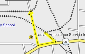
Below the railroad is mentioned. I spent some time
in Cheneyville trying to figure out how the Southern
Pacific met the Texas & Pacific. It was a hot long
afternoon similar to this one.

I was heartened by torn up ties. I could lead you to believe
these were from the SP, not so. Still, they were a mood
setter.

Before the hunt on the south side of the tracks began, I
looked up and down the north side. I couldn't see the connection
from that side. The high weeds, below on the right, marked
the spot.
.jpg)
The truth lay beyond the rails.
.jpg)
Looking north.
.jpg)
Looking south.
.jpg)
.jpg)
.jpg)
Then I went into the farmer's field. The GPS said I was there.
The farmer knew they were there, also.
.jpg)
.jpg)
.jpg)
The next stops would be Haas and Eola to the south.

I'll pop in a few pictures of Front Street, US 71.
Some are older, some are more recent. Some depict
how Cheneyville has deteriorated quickly in the last
of the 20th and the beginning of the 21'st Centuries.
Her most recent loss has been the parish jail, once a school.
There is not much left alive in Cheneyville.
Below was found where she describes "Old Town" as being.

This may or not be of what she is speaking.
.jpg)
Not all the homes were in bad shape.

This is the present Methodist Church. That is my guess
based on its design.


Here's the old dominoes pavilion on Front Street near
the railroad tracks. Once it was a place where old men
played the day away.

Now it's not.

This shot was taken from there.

A lovely place.

Old businesses.

This is one of the once busy antique shops.

This was once a home near the tracks.
.jpg)


This picture was taken on the mushroom ride. It is not
my best. Below it will be better.
.jpg)
.jpg)

.jpg)
I had mistaken this tour sign for the Northup Tour.
The Bennett places were on the Northup Tour, named
for a man who had been kidnapped into slavery in these
regions. Much more on that later.
.jpg)
.jpg)
.jpg)
.jpg)

.jpg)
Of course that's the Boeuf.
.jpg) '
'
Notice the use of the word, "Planter". He was not a farmer.
Farmers are workers. The "Planter" may have dallied in
the soil from time to time, but it was not his job. He had
overseers for that.
.jpg)
This house sat nearby. I suspect it had something to do
with the cemetery.
.jpg)
The author is black, thus the familiarity with the historical
places of interest to that community.

What was the "Alliance"?
{Photos needed}
.
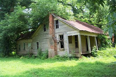
I was in the Bennett Store a while back. It was the last
opportunity to visit it while it was there. I wonder if the
ghosts made the trip?
_(400_x_400).jpg)
Now the store and house are saved, elsewhere.
_(400_x_400).jpg)
This is the way it looked in the state I found it on US 71.

I was afraid to go upstairs. Shame on me.

Looking out the side. That is a kitchen in green.

Across the highway was the family home.


The Cheneyville Horror?

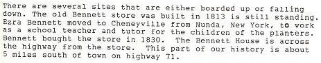
In response to my long ago write, a reader, Ms. June wrote,
" Your site and photos brought back so many good
memories of my childhood in Cheneyville, Louisiana.
I wanted to give you the story about the house and
store on page 2 of your Alex to Washington trip.
That's the old Bennett house and store. My friend
Veronica grew up in that house. She once told me
that the house had at one point been a funeral
parlor. She may have just said that to scare me
though!" [The store and house are two different
places.
"The store was vacant and we played in there often.
Someone found a box of receipts including one from
1817 (when the store was new) that showed James
Bowie shopped there; he invented his knife nearby
and once owned a lot in Cheneyville".
"We never went up those stairs either! Ezra Bennett
came from New York and bought the house and store
in the 1830s. He is buried in the graveyard over
by Trinity Episcopal Church. I'm so sad to see the
house and store are in ruins now. I wish someone
would restore them".
"Thanks for the photos and the trip back in time. :) "
Ms. June, you got your wish.
Here's a bit about Bowie's presence in the area.
"In his teens James Bowie worked in Avoyelles and Rapides parishes, where he floated lumber to market. He invested in property on the Bayou Boeuf and traded in 1817–18 at what is now Bennett's Store, south of Cheneyville. He was fond of hunting and fishing, and family tradition says that he caught and rode wild horses, rode alligators, and trapped bears. When grown, Bowie was described by his brother John as "a stout, rather raw-boned man, of six feet height, weighed 180 pounds." He had light-colored hair, keen gray eyes "rather deep set in his head," a fair complexion, and high cheek-bones. Bowie had an "open, frank disposition," but when aroused by an insult, his anger was terrible. During the War of 1812, James and Rezin joined the Second Division, Consolidated, a unit that contained the Seventeenth through Nineteenth regiments, drawn from Avoyelles, Rapides, Natchitoches, Catahoula, and Ouachita parishes. In January 1815, according to family records, the brothers were on their way to join Andrew Jackson's forces at New Orleans when the war ended".
From Here
Returning to Mary Soloman's pamphlet:


Cheneyville was joined in the anti lottery movement.
This is a little boring but what seems important to
me is the list of prominent people in the community.


That does sound a little familiar. These guys were T Party
People. They saw what crooked government was doing
and found it "repugnant to ur state pride, an insult to
our manhood, abhorrent to public morality, contrary to
our State Constitution, consequently undemocratic and
contrary to all Democratic principles".
I am sure that if you crossed any of these gents, a duel
on the sandbar would be your next invitation.

They saw themselves as leaders.

Of interest here is the mention of the Town Talk, still
Alexandria's newspaper.
The members:

Below is a list of pictures I did not get from my source.


This is the closing picture from the ride. After the Anti-
Lottery call to arms, it's a bit weak. What you have here
is two old guys who can't figure out where to park their
bikes. Possibly it was the heat to offer them an excuse
I took 20 more pictures as they moved around the field.
I'll spare you those.
More below now that the ride is safely over.
Safe for you and I.
.jpg)
Remember I mentioned the Northup Tour back at Trinity
Episcopal. He landed in this area and kept a diary of
his time spent as a slave. It is a picture through another
lens of how things were.
Below are excerpts from Northup's odyssey. Be aware, it
is written by a man whose freedom was stolen. I have
not read the whole book. I copied it and can send it to
you. It is out of copyright.
I am assuming the tour is named after him. It now
longer exists as I've found nothing about it.
I searched the book using "Boeuf" and "Cheneyville "
as key words. I came up with these passages. I'll let
you read them in peace.
"I bade farewell to my good friends at the opening, and departed with my new master Tibeats. We went down to the plantation on Bayou Boeuf, distant twenty-seven miles from the Pine Woods, to complete the unfinished contract. Bayou Boeuf is a sluggish, winding stream—one of those stagnant bodies of water common in that region, setting back from Red River. It stretches from a point not far from Alexandra, in a south-easterly direction, and following its tortuous course, is more than fifty miles in length. Large cotton and sugar plantations line each shore, extending back to the borders of interminable swamps. It is alive with alligators, rendering it unsafe for swine, or unthinking slave children to stroll along its banks. Upon a bend in this bayou, a short distance from Cheneyville, was situated the plantation of Madam Ford—her brother, Peter Tanner, a great landholder, living on the opposite side".
"He had been a driver and overseer in his younger years, but at this time was in possession of a plantation on Bayou Huff Power, two and a half miles from Holmesville, (on the map) eighteen from Marksville, and twelve from Cheneyville. It belonged to Joseph B. Roberts, his wife's uncle, and was leased by Epps. His principal business was raising cotton, and inasmuch as some may read this book who have never seen a cotton field, a description of the manner of its culture may not be out of place".
I know I've seen an "Epps, Louisiana". He was a cruel drunk from Northup's description.
"Mistress Epps was not naturally such an evil woman, after all. She was possessed of the devil, jealousy, it is true, but aside from that, there was much in her character to admire. Her father, Mr. Roberts, resided in Cheneyville, an influential and honorable man, and as much respected throughout the parish as any other citizen. She had been well educated at some institution this side of the Mississippi; was beautiful, accomplished, and usually good-humored. She was kind to all of us but Patsy—frequently, in the absence of her husband, sending out to us some little
dainty from her own table. In other situations—in a different society from that which exists on the shores of Bayou Boeuf, she would have been pronounced an elegant and fascinating woman. An ill wind it was that blew her into the arms of Epps".
"In the course of a fortnight, four black girls came down from Eldret's plantation—Charlotte, Fanny, Cresia and Nelly. They were all large and stout. Axes were put into their hands, and they were sent with Sam and myself to cut trees. They were excellent choppers, the largest oak or sycamore standing but a brief season before their heavy and well-directed blows. At piling logs, they were equal to any man. There are lumberwomen as well as lumbermen in the forests of the South. In fact, in the region of the Bayou Boeuf they perform their share of all the labor required on the plantation. They plough, drag, drive team, clear wild lands, work on the highway, and so forth. Some planters, owning large cotton and sugar plantations, have none other than the labor of slave women. Such an one is Jim Burns, who lives on the north shore of the bayou, opposite the plantation of John Fogaman".
"There are no inns along the highways in that portion of the State where I sojourned. I was wholly destitute of money, neither did I carry any provisions, on my journey from the Big Cane to Bayou Boeuf; nevertheless, with his pass in his hand, a slave need never suffer from hunger or from thirst. It is only necessary to present it to the master or overseer of a plantation, and state his wants, when he will be sent round to the kitchen and provided with food or shelter, as the case may require. The traveler stops at any house and calls for a meal with as much freedom as if it was a public tavern. It is the general custom of the country. Whatever their faults may be, it is certain the inhabitants along Red River, and around the bayous in the interior of Louisiana are not wanting in hospitality".
Aren't you guys done yet?
Barbreck on the Southern Pacific
From the Guest Book:
"I have been doing genealogy research. My family was from the Louisiana area and my Great Aunt Pearl wrote about the Barbreck Plantation. She wrote: "Barbreck was the most important of the three plantations. On it were located the depot, sugar mill, store, post office, cotton gin and blacksmith shop." Her book is 'The Door is Open-Commemorating the 150th Anniversary of the Louisiana Purchase'. I thought you might find this interesting since you were looking for the Barbreck Depot. I haven't been to visit this area, but, looking at Google Maps, it shows Barbreck off of Daniel Road from La.29. Thank you for the little peek into the countryside of this area. It looks wonderful.
Sincerely, Leanna"
This one got my attention,no matter that I had the winter cold and flu funkies.
Immediately upon swinging my leg over the saddle, I felt much better. I almost explained the lessening symptoms, but I won't take you there. Knowing that this one might have a premature conclusion due my condition, I hastefully flew up the Teche Valley until I reached Arnaudville. I decided to take La.347 north. Upon exiting town, I passed Railroad Ave. I am a sucker for "Railroad Avenues". They have led me to some great discoveries. How obvious a hint can the history god offer up? Duh. I took a bunch of pictures of the avenue, the presumed bayou crossing, and a road which now occupies the rail's right of way going south. I'm not showing those pictures to you here. I'll insert a link later if you are a sucker for that kind of stuff. I realized that this right of way was part of the Cade to St.Martinville to Breaux Bridge to Arnaudville to Leonville to Port Barre, Southern Pacific route. I knew there were rails leaving BB going north which helped with that conclusion. The old humps have been leveled and it is so old my old software does not show it. You can still make it out on satellite if you have an idea of where to look. The pictures of the route laid over the satellite pictures will be on that added link.
No, it won't. Everett has found the maps and they will be on that link. Or, maybe, I'll put both.
As I rode from Arnaudville to Leonville, I could see the slightly raised bed out in the swamp to the east. The season, with its decreased foliage, has made peering a lot easier. From a familiar road going east off 347, I made out what I suspected to be the right of way bending toward Leonville. Entering town, I saw an old man riding a bicycle down the road. I knew he had been sent to show me the way. We talked in front of this building, an appropriate place to have a history discussion.
.jpg)
The gentleman was cheerfully helpful and we might have had a longer talk if we had not been interrupted by other people. He told me that the railroad had followed 347, as I suspected. I asked him where the depot was. He offered to lead me down there on his bicycle before the other people showed up. I did go to where he described and found a large cement support block I suspect was part of the depot area, if not the depot itself. He told me that a lady that owns much of the property along there has the Leonville Depot sign and that she has been offered big bucks for it and refused to sell. I commend her, somethings just aren't for sale. Somethings are, depends. Here's that cement. I have since thought of so many questions I could have asked him. That's the way it always is.
.jpg)
I know, I should have put the cement picture on that link page for the train nuts, but.....I will.
Back in the day, this site was almost completely consumed with pictures of old houses and barns. Being the last day of the year, a bit of nostalgia has gripped me or maybe it's my cold meds? Whatever, here's a barn that was near the ghost tracks.
.jpg)
There were a few more taken of that rail route. They'll be at the SP:Cade to Port Barre link. I know you want to get on up the line.
I arrived in Port Barre for one of those just in time stops. I commend the City of Port Barre for their very clean portable restroom located at the rest stop. Too bad the historical marker is down in the mud. Someone might of hit it trying to get to the very clean portable restroom as quickly as I did.
.jpg)
I went west on US 190, then I flew up 743 to 103 and shot into Washington, mindful of my unfinished business there. By the way, all of the roads pictured here, except I-49 and US 190, are prime riding roads. I mention that as guidance to such roads is a prime mission of the Back Road Riding and Highways Reviewed websites.

After leaving Washington on La.10. I turned north on La.182 which turns into La.29.
I'm going to close this page with a bunch of pictures of this one field. It's the drugs, Louise. I'll eat some lunch and we'll be on to Barbreck, Whiteville Methodist, the hunters, the lady, and more help from the history deity.
.jpg)
.jpg)
.jpg)
And, the pink barn has always been a much photographed favorite.
.jpg)

After reaching La.29, I pulled over to prepare myself for what I might find. Explaining my purpose to the surprised land owner is always a challenge. I usually appear deranged which brings a frown of suspicion upon the face of my impatient victim. My explanations are usually way too long. I should read a book on personal introductions.
These are my notes on her notes, so far. Leanna has promised more. This is explained from her point of view, that being her interest in her family history. I'm including all that she has because, believe it or not, people reading this might connect and another jubilation of cousins connecting could occur. If not interested in this part, you know how to scroll down a page.
HER WORDS, I may have added a comma as I keep a large supply. I have also rearranged the sentences to be in a time line:
Here is some of the information that I have been able to compile pertaining to my family.....
My GGGrandfather was Hiram Gustavus Robert(s).
Hiram purchased the plantation form Pierre Gabriel Wartelle, a prominent sugar planter. He was a captain in the French Army under the Emperor Napoleon Bonaparte and came to America after the battle of Waterloo. He acquired much property in St. Landry parish and there built the old Wartelle home in 1828 which is yet standing. (This information was taken from Terry D. Smith, The Limbs and Branches of the Smith Family Tree, Rootsweb).
Maybe, Wartelle purchased the land from Marsden Campbell ( me: the original owner?) Anyway, I have a copy of the recorder files from 20 October, 1859. It states that it is a certain plantation situated in the....on the East and south Banks of Bayou Boeuf...bounded on the upper or north side by lands of the Henry J.Dunbar family and over the lower or south side of land of Green Hudspeth, East and the further Domain and land of Gene Andreus....
My GGGrandfather, Hiram G.Robert(s) was married to Mary J. Daniel(s). I believe her brother was John Wesley Daniel, who later owned part or all of the plantation in later years. Hiram Roberts had six daughters and one son:
Sarah S. Roberts, 1845 - ?
Elizabeth Harriet Roberts, 1846 - 1883 married Isam Vest
Susan Roberts, 1848 - 1927 married Jacob Matthews
Emma Jane Roberts, 1850 - 1927 married Mercina Starks Street (mine)
Willaim J. Roberts, 1857 - 1949 married Virginia Montgomery
Matilda Roberts, 1860 - 1942 DeWitt I Fogleman
Fannie Roberts, 1862 - ? married Albert Bundick.
Through scuttlebutt, only, I have heard that (GGGFather) Hiram G. Roberts was in the Civil War, was wounded and taken prisoner and died in New Orleans around 1863. I have never been able to confirm this information but have heard about it from more than one source. There was a Judgment of Partition, May 11th 1872, (this would be after the death of Mary Daniel Roberts) between John W. Daniel and the Roberts children. Who knows?
ME: Then she goes on to explain a bit about the plantation and her great aunt.
My Great Aunt Pearl was born in 1894 at the plantation. I think at this time it would have been owned primarily by John Wesley Daniel, her great uncle. She talks, also, about a company owning it(?).
In, or about, 1948, she must have visited again because she wrote quite a bit about the plantation in her book. She didn't include any family information since she was writing a scholarly text. There are about eight pages describing the life and work on the plantation. If you would like, I could transcribe these pages but for now here is a description of the house itself.
ME: Yes, I'd like them and will insert them on this page when you have a chance. Below is quoting from Aunt Pearl's book:
"Farther up Bayou Boeuf, in the northwestern corner of St. Landry Parish, were three large sugarcane plantations, owned by a company in the latter half of the nineteenth century--St. Peters, Barbreck and Anchorage.
Back of the fields on Barbreck (originally, "Barbeck" (?) plantation was a canebrake (small bamboo) that was once the habitat of bears and was named Bear Brake. Down through the years, the bears disappeared and cattle began to use the brake as their winter home. In time the name was changed to Barbreck.
(I think the name, "Barbeck", did originally come from Marsden Campbell of Scotland (Wartelle bought the plantation from him). It is interesting how the story that Aunt Pearl knew differs. [Me:I'd like to hear that story]
Barbeck was the most important of the three plantations. On it were located the depot, sugar mill, store, post office, cotton gin and blacksmith shop. The main crop was sugarcane but some cotton was grown and enough corn was produced to feed the livestock on the place all year. Barbreck was one of the best planned plantations in its day.
All the buildings were constructed of BRICKS made by slaves from the red clay found in that area. The residence for the manager was some distance from the shaded banks of Bayou Boeuf.
ME: I've tried to apply this description to the house I found. Warm up your imagination.
The front and back walls of the one and one-half storied building were flush with the ground.
Beneath the galleries the spaces between the pillars were trellis-enclosed.
The house was surrounded by a cypress picket fence painted white; live oaks stood in front, sides and back, pecan trees on the sides and to the rear; a flower garden of jasmines and roses in front; vines draped themselves gracefully over the trellis and fence that separated the front and back yards.
A wide brick walk led to the broad low steps of the deep gallery running the entire length of the house with six large columns across the front.
............In another section [of the book]
If you stood on the rear gallery, to the right, you would see the underground brick cistern surrounded by a floor, level with the walk that led from the gallery, all enclosed with lattice work. This cistern water was used for household purposes only; it was caught after the winter rains had set in.
To the left of the house was a small brick building used as the summer kitchen and reached by a covered brick walk.
ME:
I was at the beginning of the gravel road named "Daniel". I felt in sync.
.jpg)
.jpg)
I was practicing my spiel.
.jpg)
I was figuring that the only thing here was farming stuff.
I topped the bridge. It looked familiar.
.jpg)
Real familiar. It sure was heavy duty for a farm bridge.
.jpg)
The reddish brown waters of Bayou Boeuf lay below.
.jpg)
I saw someone working on a boat. I approached, waving and being jovial. I proceeded to introduce myself, explaining that I was not from Opelousas, when he asked, and how my name was spelled several times. I then went into an explanation of my mission and my desires. I think I appeared confused. At the end, I didn't know why I was there.
He did the sideways hand motion which means "shut up, none of that matters". He proceeded to say he was not the guy I needed to talk to and that he could not give me permission to be on the property or take pictures. Thank goodness, I might have a second chance.
He said the owner was in Opelousas. It was over, I wouldn't have access. But......he'd call him and ask. I heard trumpets blow. After what seemed like an eternity of BS back and forth on the phone, he got down to telling the owner that there was some guy there that wanted to take pictures of the old house. Wow, there was an old house. He hadn't mentioned that. I guess he didn't want me to bull rush him and take the plunder without permission. He said that I should stay away from the building since it was not stable and if I got hurt, it would be on his shoulders. I complied and took these shots. No, Al, I didn't go in. It was that scary.
Sorry, that's on the NEXT PAGE. I'm getting drowsy, very drowsy.
Let me add this while I'm thinking of it. The property is now owned by Daniel "somename". In my explanation to the worker, every time I said "Daniel", I got a smile of recognition. When I finally made it clear that Daniel was the last name, the fog thickened as it fell upon us all.
Hopefully the fog that seemed to hang over yesterday's page has lifted. To answer a lingering question, which I know you have, the bridge looked familiar because it was a part of the same bridge that I found in two places near LeCompte on the Depot Adventure. Evidently, the old Red River Bridge at Moncla, north of Marksville, was cut up into many pieces by some aspiring entrepreneur and sold to residents up and down the Boeuf and possibly other streams. The Red River is very wide at Moncla and the bridge would have to have been of a corresponding length to complete the crossing, thus affording the entrepreneur many pieces. I wonder if there's codeine in that cough medicine? This may get silly, the fog seems thicker.
New Entry: Leanna has sent a chapter from her aunt's book which includes passages regarding Barbeck. It will be at the bottom of the page. I would suggest reading it before looking at the house pictures.
I took many pictures of the house. One thing bothers me, the underground cistern. I think it should have been at the back of the house. Could it have been at the front? This is why I bring Al along, he can figure these questions out. Tell you what I'm going to do, and you can make up your own mind, mine being what it presently is.
I'll transfer the description on the last page to this page so you can look at the house, look at the description, look at the house, look at the description ........and make your own conclusion as if this is the house or not. You may offer your opinions, even if biased.
"All the buildings were constructed of BRICKS made by slaves from the red clay found in that area. [I have a picture of the kiln] The residence for the manager was some distance from the shaded banks of Bayou Boeuf.
The front and back walls of the one and one-half storied building were flush with the ground. (yes, the walls are flush, but it is clearly two full stories)
Beneath the galleries the spaces between the pillars were trellis-enclosed. (gone)
The house was surrounded by a cypress picket fence painted white; live oaks stood in front, sides and back, pecan trees on the sides and to the rear; a flower garden of jasmines and roses in front; vines draped themselves gracefully over the trellis and fence that separated the front and back yards. (just imagine)
A wide brick walk led to the broad low steps of the deep gallery running the entire length of the house with six large columns across the front. (I see the steps, why didn't she say "width" of the house if looking at it from the front?)
If you stood on the rear gallery, to the right, you would see the underground brick cistern surrounded by a floor, level with the walk that led from the gallery, all enclosed with lattice work. This cistern water was used for household purposes only; it was caught after the winter rains had set in.
(That brick "well" must have been the cistern. It was not level with any walk.)
To the left of the house was a small brick building used as the summer kitchen and reached by a covered brick walk." (I didn't see it)
On to the house.
After Danny, the present owner, had told Bob that it was OK for me to take a few pictures, I rode back to the house. Mercy.
.jpg)
.jpg)
I was swept with a wave of sadness, especially after Bob told me that it could have been saved. The following pictures are in the order which they were taken. I was moving from what I call the front, the cistern side, then around to the left and behind.
Below taken from front left.
.jpg)
Left side and left rear. Notice the chimney behind the bay windows. Also, look at the enclosed "widow walk" atop the house.
.jpg)
The next shot is from the rear. Notice the extensive large gutter system culminating in a collection funnel. The water should have gone to the cistern which is on the other side of the house. This does not make sense.
.jpg)
Back to the "front". I know you want to look into the cistern.
.jpg)
Maybe it wasn't the cistern but the septic tank? How did water get to the house?
.jpg)
And, this is the right side. Notice the bay window and chimney just like the left side.
.jpg)
Here's the kiln, or what's left of it, now an island in a crawfish pond. That part of the explanation, the "homemade bricks" part, is right on.
.jpg)
Here's an overview of the place. CLICK IT TO ENLARGE.

A parting shot:
.jpg)
I waved to Bob who was still busy putting fenders on his mud boat while trying to explain to his wife on the cellphone why and that he'd be along as soon as he was finished. You tell em Bob.
To relate the drama of my exit, I took the following pictures. This is the Boeuf and a pump sucking water from her to probably flood the crawfish pond.
.jpg)
And over the Moncla bridge one more time.
.jpg)
And a look down the old red Boeuf.
.jpg)
It was a melancholy exit. I figured I'd ride across the highway and see if anything was left of the Barbreck depot. That stretch would be the one dark moment of the ride.
Read below or CLICK HERE TO GO TO THE NEXT PAGE
The next paragraph will be Leanna's words, although rearranged a bit. I have decided not to amend any of her aunt's historical writings, though Leanna suggested I might want to. That would be blasphemy. The word she was worried about is "Negro". That word's use, in her aunt's text, is synonymous with "worker", and that is all. It is a pretty good history lesson on St.Landry Parish and a wonderful description of general plantation life and a look inside Barbreck Plantation. From here down are Leanna's words and those of her aunt's.
Leanna:
Now, on the book. Some of the dates are off, Aunt Pearl's book was published in 1953. She was born in 1892 or 1890 (according to conflicting sources). I am going to send the pages of the book first. I realize that she uses language that is not accepted as politically correct. I will not in any way be offended if you think some of this should not be posted. I have mixed feelings about it. On one hand this is what she wrote and my Aunt Pearl didn't have a mean bone in her body that I have ever heard. She wrote in terms of the time she lived. Then again, it can be a very sensitive subject.
The Door is Open
Commemorating the 150th Anniversary of the Louisiana Purchase
Commemorating the 150th Anniversary of the Louisiana Purchase
by Pearl Street
Copyright, 1953, by Pearl Street
Published by Pageant Press, New York, NY
Chapter 3, St. Landry Parish
ST. LANDRY PARISH is one of the oldest parishes in Louisiana. It has been more than two hundred and fifty years since the first white men made their appearance in the southwest section of Louisiana. This fertile land was given to the Opelousas tribe of Indians. The name Opelousas is of indefinite origin. Some historians have translated it to mean Man with black leg, as a description of the Indians whose legs were darker than the rest of their bodies, while others contend that it means Salt water and has recourse to the fact that this vast prairie was once a part of the sea. The Indians have now disappeared from this region, but the entire tribe visited Opelousas about 1850 for the last time.
The first white men to settle here were the French who established a settlement about 1690. They held this Louisiana territory until 1762, when it was sold to Spain by Napoleon Bonaparte to keep England from acquiring it. The Spaniards occupied the country until 1803, when it was sold to France, who within a few days, sold the vast territory to the United States. The Spaniards built a military and trading post at Opelousas in 1765. This village, El Poste de Opelousas, became the governing center of the entire southwestern part of the territory. The post, a large garrison, was established near the site of the present Academy of the Immaculate Conception. The pioneers built their homes near it for protection. Some of the Spaniards remained after the fort was dismantled and this became the nucleus of Opelousas.
St. Landry Parish, having derived the name from St. Landry Catholic Church, was established by a legislative act and approved on April 10, 1805. At first the parish included all the land between the Atchafalaya River on the east, the Sabine River on the west, between the southern boundaries of Rapides and Vernon Parishes on the north, and the northern boundaries of Lafayette and St. Martin Parishes on the south. Since then six other parishes--Acadia, Evangeline, Calcasieu, Jefferson Davis, Beauregard and Allen--have been formed from this wide expanse of land.
As the volume of business increased rapidly, the lack of suitable roads began to present a problem. Territorial legislature passed an act that provided a certain sum of money be appropriated for road construction. The land was cleared of trees and stumps, the holes filled with brush and all were covered with earth. Crude bridges were constructed across some streams while ferries were installed across others. After the road was completed men with shovels, spades, axes and wheelbarrows donated their time to keep it in good condition.
During the early days stock raising was the important business. Cattle and hides were sent to New Orleans by the way of Washington on Bayou Courtableau and by connecting waterways which were navigable by inland boats. This business continued to expand and by the end of the nineteenth century immense herds of cattle were being moved over the Old Spanish Trail to New Orleans, where they were slaughtered and distributed throughout the country. The cattle rustlers had no misgivings if they murdered a man and confiscated his cattle; consequently, cattle raising was eventually replaced by cotton growing. In the last few years the raising of sweet potatoes has become a parish-wide occupation.
The first schools in the parish were St. Charles College, which later became a seminary for scholastics, and the Convent of the Sacred Heart which was instituted by the Sisters Marianites at Grand Coteau in 1823 for the higher education of girls. Formerly, the young people had been sent to New Orleans, to the east or to France. These two colleges, with a number of private teachers, offered the only formal education in the parish until 1840, when Franklin College was established. It was located on the site presently occupied by the Opelousas Cotton Oil Mill. A. Mr. White conducted a private school in Opelousas before the Civil War. Immediately after the war there were no public schools in the parish. For a number of years there were only St. Mary’s Academy and the Opelousas Female Institute. Other private nondenominational schools were scattered throughout the parish from Washington to Barbreck along Bayou Boeuf. The young men of St. Landry attended St. Mary’s Academy.
The Reconstruction era was marked by social and political disturbances when an alarming outbreak occurred between the whites and blacks when the carpet-bag government was forced on the citizens of Louisiana. Naturally, at each election, relations became more strained until finally in the riot of 1896, Negroes were eliminated from voting.
After the courthouse was destroyed by fire in 1886, a heated contest followed between Opelousas and Washington as to where the new courthouse would be built. Finally, a referendum was held. The results showed that the citizens of the parish favored Opelousas. A courthouse was erected and served until 1938 when a new modernized structure replaced the fifty-two-year-old building.
The Opelousas and Northwestern was the first railroad to be built in the parish. The roadbed was finished about 1850, but for some reason the train never was operated. Morgan’s Louisiana and Texas Railroad was built through the parish from Lafayette to Alexandria, with the right of way being given by the landowners. The Opelousas, Gulf and Northeastern was taken over by the Texas and Pacific and went through Opelousas to Crowley in 1907. In two more years, the Texas and Missouri Railroad was extended through Opelousas to Beaumont and Houston, Texas.
The first bank of the parish was organized a few years before the first railroad was built. It was located on the block south of Courthouse Square and functioned until 1862. The St. Landry Bank was organized in 1890.
The newspapers in St. Landry have had a long history, too. The Opelousas Gazette, the first paper, was started in September, 1827 and continued until 1852. Andre Meynier followed the lead of the Gazette when he founded the Opelousas Courier continuing until 1910. The St. Landry Whig was established in 1844; in 1885 the Whig was succeeded by the Opelousas Patriot, which was temporarily withdrawn at the beginning of the Civil War. In 1867, a Republican paper, the St. Landry Progress, was organized with Michel Vidal, Cassimir E. Durand and Emerson Bentley as co-editors, but due o their seditious utterances the people were aroused and there were a number of clashes between them and the carpet-bag government with the press being thrown into Tesson Bayou later. After the war the Southern Sentinal was born, and in 1890, a new paper, the Clarion, was begun. Later it took over the Progress and became the Clarion-Progress. The St. Landry Commoner was started in 1910 but it was discontinued in 1919.
The early settlers were people of different nationalities; at first the French and Spanish settled in this area, followed later by the Americans--who were regarded as usurpers. As the French had settled at this trading post parlez-vous francais? is still heard and used in the courts.
Under the Spanish regime, the town was known as El Poste de Opelousas. Its mien indicates that it was a pioneer settlement, setting it aloof as not being an ordinary city.
Six miles above Opelousas is the little town of Washington that was settled about 1800 and incorporated in 1835. It was the chief shipping port in this area due to its location. It is about two miles below the point at which Bayou Boeuf and Bayou Cocodrie meet to form Bayou Courtableau, flowing on to unite with Bayou Teche and finally uniting with the mighty waters of the gulf forming an important link in water transportation for this area.
Above Washington, the pioneers who came in the 1840’s and later blazed their way into a wilderness of trees along Bayou Boeuf. These early settlers, sturdy stock from Mississippi, had their slaves and money to start new homes. They did not have Indians to harass them, but they had to clear the forest, till the soil, and build small homes of hand-hewn shingles, siding, foundations of Louisiana’s everlasting cypress, and handmade bricks for chimneys. At first the cabins were small, but as time passed, they became substantial houses. These venerable homes are fast disappearing through the ravages of time, fire, and the very modern way of repairing with composition siding and roofing.
Back of the homes were the cotton fields that supplied the family with money. In the spring the ground was plowed several times in order that the soil would be well-turned over and made into new rows. After the Negroes had prepared the ground the cotton seeds were planted. As the plants grew, cultivators were used to keep the land mellow and porous enough to enable the young plants to get food and water. After several weeks white blossoms appeared, then little hard green bolls. As they grew and opened, snowy-white cotton tumbled in wild profusion and gave the field a snow-flecked appearance. When cotton-picking time came, the Negroes, each with a large bag made of canvas or duck slung from their shoulders by means of a wide band, started picking. There was always a great deal of friendly rivalry among them to see who could pick the most cotton, as they were paid according to the number of pounds picked. Away they went, while their nimble fingers plucked the fleecy cotton from the open dried pods. Some were more rapid pickers than others and were able to empty their filled bags in the baskets placed on the turning row. They created a form of singing, a forerunner of jazz, as they worked. Sometimes they chanted their church hymns, for they were deeply religious. While they sang or chanted they gathered speed. When quitting time came, the cotton was weighed on the steelyard suspended from a tree near the storehouse. As soon as enough cotton was picked, it was sent to the gin nearby in wagons with deep beds.
Inside the gin there was the humming sound of running machinery. The cotton, after it was separated from the seeds, was baled, wrapped in burlap, and held with strong iron bands. These bales weighed about four hundred and fifty to five hundred pounds and were graded by the cotton buyer.
Time has wrought a change. A paved highway has replaced the old road along the meandering bayou. You can stand where cypress and oak trees shade you while weeping willows, whose branches sway and dip gracefully near the water, enhance the beauty of this spot. High water has caused havoc, too. In some places the old road had been washed away or undermined by the current; even the small footbridges have been caught in the sweep of time and are no more. Tall red or white-washed brick chimneys stood like regal sentinels daring anyone to enter the sacred grounds overgrown with Cherokee roses, briers and tall grass--all matted together to form a barrier to the intruder. You stand at the entrance to what was once a lovely garden and dream of the people who once lived here. Anywhere from ten to thirty slaves helped the master and mistress to care for the small plantation; the tow-storied white frame structure, with deep galleries, stood among the oak trees in the well-kept flower garden, with the large vegetable garden in the rear. Now a flock of crows flies noisily over the scene and breaks the spell of enchantment.
Farther up Bayou Boeuf, in the northwestern corner of St. Landry Parish, were three large sugar-cane plantations, owned by a company in the latter half of the nineteenth century--St. Peters, Barbreck and Anchorage.
Back of the fields on Barbreck plantation was a canebrake (small bamboo) that was once the habitat of bears and was named Bear Brake. Down through the years, the bears disappeared and cattle began to use the brake as their winter home. In time the name was changed to Barbreck.
Barbeck was the most important of the three plantations. On it were located the depot, sugar mill, store, post office, cotton gin and blacksmith shop. The main crop was sugar cane but some cotton was grown and enough corn was produced to feed the livestock on the place all year. Barbreck was one of the best planned plantations in its day. All the buildings were constructed of bricks made by slaves from the red clay found in that area. The residence for the manager was some distance from the shaded banks of Bayou Boeuf. The front and back walls of the one and one-half storied building were flush with the ground. Beneath the galleries the spaces between the pillars were trellis-enclosed. The house was surrounded by a cypress picket fence painted white; live oaks stood in front, sides and back, pecan trees on the sides and to the rear; a flower garden of jasmines and roses in front; vines draped themselves gracefully over the trellis and fence that separated the front and back yards. A wide brick walk led to the broad low steps of the deep gallery running the entire length of the house with six large columns across the front.
If you came to visit at Barbreck, you were met at the door by Mrs. Ronson. White-haired, shoulders erect, energetic, she was dressed in the style of long ago with an heirloom cameo at the neckline. She could reminisce and yet not lose the modern touch. The glassed double-doored entrance, flanked by small panes of light, led into a large hall with the stairway situated in the rear--where the family ascended or descended without being seen. Glimpses of furnishings in the large high-ceilinged rooms revealed large armoires in each bedroom--four-poster beds with testers--a baby’s cradle and trundle bed for the youngsters, dressers, washstands with marble tops, oil lamps in wall brackets. As there were no bathrooms, each bedroom contained a china toilet set. The parlor with its lovely old furnishings was a large airy room. The whatnot with its china figurines, milk glass pieces of owl, chicken, pin trays and plates with open-work rims offered a delight to the collector of rare china. The well-worn sofa was to the left. The space between two windows was occupied by an open fireplace with its brass andirons, tongs and shovel, had the kindling and logs ready for the match. An old clock on the mantel struck the hour. On the walls were several pictures of the family made on different occasions. A small mahogany marble-topped table with stereoscope and pictures stood near a window. Several straight-backed chairs and a secretary completed the furnishings of the old parlor. In the dining room the massive table and chairs did not show the marks of usage. As you left the room, you would note the china closet filled with china, crystal and rare pieces handed down from generation to generation.
Upstairs there were only two bedrooms and a hall, a duplicate of the one below. Three dormer windows broke the severity of the roof lines. Their wide sills were embellished with potted plants. Just off the bedrooms was an unfinished part of the attic. Here were stored cotton cards, an old spinning wheel and an hand loom. The cards were boards with handles and were covered with wire bristles. A card was held in one hand and brushed with cotton; the other card was drawn over this cotton with the hands pulling against each other. After this was done several times to remove any foreign matter, the carded cotton was deftly removed with a slight twist of the top card. The spinning wheel with its single spindle holding the cotton or wool was operated by foot. After the cotton was spun into thread, it was woven into various articles--curtain goods, spreads, blankets and material for clothing.
If you stood on the rear gallery to the right, you would see the underground brick cistern surrounded by a floor, level with the walk that led from the gallery, all enclosed with lattice work. This cistern water was used for household purposes only; it was caught after the winter rains had set in. To the left of the house was a small brick building used as the summer kitchen and reached by a covered brick walk. An immense brick oven filled one end of the kitchen and was used to do all the baking for the plantation. Adjoining the kitchen was a vast storeroom containing barrels of flour, meal, coffee and sugar; quantities of hams, shoulders, bacon, salted sides, smoked sausages, strings of onions, garlic and red peppers were suspended from the beams overhead. In the room back of the kitchen, ashes were stored to be used in making lye soap following hog-killing time, when the Negroes revelled in chitterlings and hoecake.
On the way to the quarters, you would pass the plantation bell mounted on a scaffolding about ten feet high. This bell played an important part in plantation life. The ringing of the bell was entrusted to a member of the family. It was this person’s duty to see that it was rung at seven, twelve and one o’clock. In case of fire the bell was rung sharply and constantly, while the Negroes hurried to save Master’s house or one of theirs. Just beyond the gate was an avenue of magnificent oak trees whose branches interlace and formed a canopy. This was the playground of the little Negro children. No less impressive were the thirteen brick houses on one side of the avenue and twelve on the side with the storehouse. Each house had four rooms and two chimneys with an underground cistern between every two houses. Here lived the Negroes of the plantation; the men and boys cultivating the cane, corn and cotton, while a few of the women and girls worked at the Big House helping Mis’ Mary. The mistress had to see that the rations were weighed, the gardens planted and worked, the sick looked after, and that the house servants were properly trained in their different tasks. Every Saturday all the Negroes stopped work at twelve; the women washed and ironed; the men went to the store, collected their checks and rations. Sunday they went to the Rising Star Baptist Church. Baptismal services were held every spring down by the bridge that crossed Bayou Boeuf.
To the left rear was the blacksmith’s shop, also of brick. Nearby was the stable for the carriage and horses. To the right of these buildings were the vegetable garden and fruit orchard. As it was a most enjoyable occasion, the children of the house accompaniedby one or two adults always insisted on going to the woods to gather wild plums, grapes and muscadines to be made into delicious jelly with a tang that made it appetizing. The Negro children picked blackberries to sell to the Big House. The hay-filled racks in the lot, the bursting corn cribs and the large stables were able to care for fifty mules or more on the place.
As you approached the sugar mill a short distance away, Mrs. Ronson explained about the planting and grinding seasons. In the fall, when the cane had ripened, the manager selected what he thought was the best cane patch to be used as seed cane. This cane was stripped, cut and placed on the ground. As several Negroes had prepared a small plot of ground with a mat of cane leaves and tops, the cut cane was placed on it until the pile was about two feet high; then it was covered with cane leaves and tops, followed by a layer of dirt. This protected the cane from freezing and it was not buried in mud. In the spring the ground was prepared by Negroes. The seed cane was dropped end to end in small furrows and covered by a plow drawn by a pair of mules. The cane sprouted from the eyes on the culms, there being an eye on each joint. This procedure was called first year planting; and it was used every other year--while stubble cane produced only one year’s growth of cane.
During warm weather the cane continued to grow and kept the sugar content low, while a freeze would ruin its quality and cause the cane to become sour. The Negro men and women gathered in the field at dawn with their cane knives. First they grabbed the top and used the small hook on the top of the knife to strip the narrow flat leaves from the stalks, topped each one, and cut them about three or four inches from the ground. The stalks fell into a position easily picked up by the loaders. While they worked, it was natural for them to sing. They moved along in rhythm to the mournful impromptu singing, letting the cadence set the time for their motions. The sugar-cane wagons, with a style of their own, drawn by a pair of mules, went up and down the rows, while Negroes threw the cane into the wagons. After the wagons were filled, they were driven to the sugar mill and waited in line to drive nearthe shed and unload by the front end of the wagon tilting at an angle so that the cane fell on the ground. Negroes placed the cane on an endless carrier made of narrow cypress slats and about four feet wide. Negroes along the carrier straightened the cane, as it had to go in lengthwise between the two huge iron rollers on the second floor level.
There was a carrier on the other side of the rollers to remove the refuse to two large bagasse burners made of brick. The juice was piped from the container to a large open kettle, later removed by pipes to a second and then a third, each time boiled a certain length of time by a low fire underneath. When it was removed to the fourth kettle, it was boiled until it reached the right consistency. This process was in charge of a man who knew when that stage was reached and could take off the “strike”, transferring it into a tank on wheels. Two Negroes who wheeled the tank down an aisle with twelve wooden vats on each side, placed the swivel copper spout over a vat and filled it with the contents from the tank. The sugar content crystallized in these vats, while the liquid dripped through cracks in the bottom to a tank--one below each vat. These drippings formed molasses with sugar content removed. The yellowish-colored crystals left in the vats were sent to a refinery and refined into sugar. At the turn of the century the little sugar mill was converted into a refinery.
Grinding season was a busy tim for all and a happy time for the children, who were plentifully supplied with sugar cane. How they enjoyed going to the sugar mill and getting a pail of that delectable concoction, cuite, to take home. It was very thick, almost taffy-like and most delicious with hot biscuits and butter. When the last stalk of sugar cane had gone between the rollers, the whistle blew. The Negroes were given a bonus and had their celebration. Mrs. Ronson’s father gave a ball in the gallery in the sugar mill.
Satisfied with my visit to Barbreck, I felt empowered and crossed La.29 onto a heavily limestoned road. I was looking for the adjoining plantations mentioned in the historic document. Here came a pickup. Though there had been no "private road" sign, I suspected it. I stopped to allow the truck to pass. He stopped, the window came down and Joe and Roy Commando stared at me with that who the :( are you look. I had done a better introduction with Bob. He said he couldn't let me proceed because I might get shot. He didn't say "accidentally shot". I told him thank you and asked him how far was I from the bayou? Our pronunciations of the bayou's name were different, him saying "Wauksha" as "walk-sure" and mine being "wauk shaw". I then repeated it as he had said it, obediently smiling as a just tutored child. He said it was about 300 feet up the road and that I could take a picture of it but then I was to leave. He left. I took the picture, but it wasn't the bayou. I think it was a ditch or the GPS was way off.
.jpg)
.jpg)
I pulled away headed back toward the highway and suddenly a big 4 wheeled utility Kawasaki Mule was on the side of me pushing me into the ditch as if pulling a cop stop. I stopped. The driver, who appeared to be a beady eyed escapee from Deliverance, asked with a perverted, twisted grin, "Can we help you?".
Wondering what his trip was and knowing he was probably armed, I, without showing how "troubled" I was at his stupid move, told him that the guy in the disappearing pickup had said I could take a picture of the bayou. He backed off, evidently not wanting to dispute his boss's directive, and waved me on. He tried to follow me out but I had had it and dropped the throttle leaving nothing but dust for him to escort. I certainly don't mind a land owner questioning me, but don't endanger my life by playing "cops" in doing so. I know I was off course, so hold the email.
At the end of the road a lady was out by the side of her house. I stopped and asked about the old train depot. She said it had been right behind her house and that it was torn down before the rails were ripped up, her guess, sometimes in the 70's. She said she'd been there for 35 years and that her brother in law had owned Barbreck for a while but had gone bankrupt. Bob had called Barbreck, "The St.Amant Place". Her husband was a St.Amant. Small world. She said she didn't remember a mill there but there was one further down the road. She also said, when I mentioned my run in with beady eyes, that the "Private Road" sign was in the ditch.
This was the pond behind her house.
.jpg)
Talking to her had been a pleasant experience which defused my temper and I was able to get my act back together. I rode on up 29 to the Whiteville Methodist Church. It is very conceivable that the residents of Barbreck could have attended there. I have roamed the graveyard and there are Civil War veterans buried within.
.jpg)
I believe Leanna said a John Wesley Daniel was one of the owners. He was named for John Wesley who founded the Methodist Church. Click Here.
I mention this because of the stained glass window. It is of a "Circuit Rider".
You can read "1870" in reverse.
.jpg)
Here is an explanation from the same Wiki link.
"Two years later, in order that the preachers might work more systematically and the societies receive their services more regularly, Wesley appointed "helpers" to definitive "circuits", each of which included at least thirty appointments a month. Believing that their usefulness and efficiency were promoted by being changed from one circuit to another every year or two, he established the "itinerancy", and insisted that his preachers submit to its rules".
.jpg)
.jpg)
The last time I was at the church, little Confederate flags marked the soldier's graves. They were missed this time.

My next stop was Gold Dust. I must find the source of that name.

I knew there was a very old store next to the tracks. It was as close to the tracks as you could get in Gold Dust. This time I came into the very small community of two or three houses. A little girl was playing in her fenced yard surrounded by protective barking dogs. I asked her to get her mom or dad for me, please. A lady came out and above the howling and barking I asked her if the old building had been the depot. She said, "YES". Bingo. I asked if I could take some pictures and she said to go right ahead.
These are them. There was more to the ride that really goes with the train trail I was following so I won't put those here as I'm getting tired. Leanna has a bunch of stuff to add and that will be put here later. Here's the Gold Dust Depot/Store.
.jpg)
Look fast, it might not make it another year.
.jpg)
.jpg)
.jpg)
And around back:
.jpg)
From there I crossed over on 106 to the Interstate and flew south.