With several boxes of yet to be posted pictures of what could be soon lost forever, I've been hit with a wave of guilt and conceded to Fred's insistence that I do one more History Hunt report. He refuses, saying this History Hunt thing is way past his job description. Agreeing with his assessment, here goes:
At the end of the Ebenezer ride, I came into Opelousas on US 190 from the west. I went over a couple of old railroad humps. I did quick glances down each old line, catching a glimpse of the stately warehouses and industry those rails served. Several buildings caught my eye as works of art. I knew I had to come back. I, also, knew Opelousas was rich with visible rail history augmented by still active routes. I have traced the old beds through town, but never really looked closely at all of the architecture, especially south of US 190.
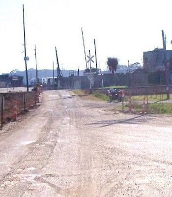
It was a warm January day, as perfect as can be. I rode into south Opelousas on La.357, the old Texas and Pacific route. I pulled off the road where the rails had crossed the highway and glanced down at the GPS. I thought, "Hunting would be good today".
Sitting at the crossroads.
The following is a collection of what one might find ugly, sleazy, dirty, rundown urban blight. Once much of it wasn't and that has to be seen for what it was, the back bone of a vibrant industrial nation, much of it built to blend and add to the beauty of the town. Granted, some of it is purely functional. Being one that finds beauty in functionality, or the once functional, I was in a museum of industrial art.
At my first stop, were three places which might have served or been served by the men of the Texas and Pacific.
I know I stuck my camera in their gates but probably found nothing that even I would find palatable. They had been hit hard by the hurricanes, no doubt, and the place was a mess but still a working business. There had been an elongated tin building facing on the rails, probably with an extensive loading dock. That was the "served by" place. The next two will be places that might have "served". the T&P fellas, say if there was a break down or some unforeseen need to stay overnight.
Across the street, a bar had borrowed the old crossing warning.
I'm guessing this little place was around when the trains came through headed to Chuchpoint and at one time Rayne down on the main east-west line. I can imagine the patrons stepping outside to enjoy the passing of the iron horse.
Having absorbed the funkyness of the crossroads, I moved on. Ahead was a bare field which once held the rails as they turned toward town.
Page 2
The next part of the ride into south Opelousas would be a test once again. If you enjoy urban track tracking, you must accept the fact that there were two sides of the tracks. Going forth with the knowledge that all racial prejudice has been erased with the election of our new president, I tentatively entered the hood knowing I'd be accepted with smiles and waves. I might mention that I actually did receive several reciprocal waves and that I timed my visit perfectly, before the school buses unloaded. I was exiting as one passed. Let's just say our president needs to get the peace and love word out with a little more fervor and tell the baby brothers that others might be packing, too.
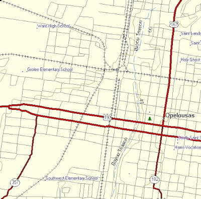
Here's my map of south Opelousas. I had started my tracking with the T&P, the one on the left, back at the "crossroads". As seen, it's accessibility was brought to a halt so I shifted over to the Southern Pacific on the right and rode down it looking for stuff.
I wanted to make sure I didn't miss anything so I rode the loop south on Railroad Ave, and then onto its continuation, Park, which led to a park. I U-turned and took this shot to commemorate making it this far. I consider luck incremental and I'm thankful for each increment.
That's looking south toward the SP's next stop, Sunset.
This is looking north up the line and into town. I took a deep breath. I was humming, "Bad Boyz Bad Boyz". Now that's a shame, Paranoia Will Destroy Ya.
There was no problem. I got back to where I'd begun the south loop and started taking pictures. I was now in the museum.
This would take dissecting.
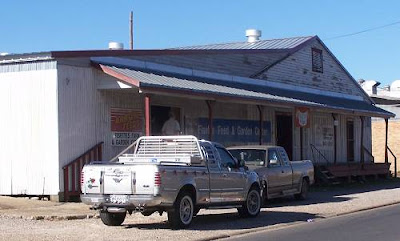
The first easy shot was of a still functioning feed store. All of these buildings have their backs on the old SP rail bed. That, of course, leads me to believe that they were serviced by the Southern Pacific trains.
After looking at the pictures, I caught something. The feed store was not always named Fisette's Farm and Garden Center. A name on the side, now fading away, commemorates a previous owner, a name I'd seen again. It bore the name Dezauche. It was Dezauche Feed and Seed. I did a wheelie. Al said I should say that from time to time to keep you from falling asleep. I may have used it prematurely.
The next building is a little sad knowing what I learned later It is the Cary Iron Works.
I skidded to a stop. Al said that would work, too. I would find Cary's original location, later.
Next was a fine building. The home of Dezauche and Sons.
Dezauche may have owned seveal blocks along here.
I was now near US 190. I would cross that busy thoroughfare and would head up North Railroad. Street construction did make things a little difficult as RR Ave, North and South, was now one way near 190 on both sides, and one way in opposite directions, depending on what side you were on. See, difficult. But, you can't let stuff like that stop you. Going the wrong way in a construction zone can't carry that much of a fine. Can it?
The top picture was taken from the north side of the Union Pacific (UP) tracks above "014" looking south toward US 190. I don't want you to get disoriented. To the west, where the bike was parked, is the Mobil installation. You know it had to have been a long time customer of the SP's. I thought it could still be serviced by the UP as it sits right in that triangle above "014". That would prove false.
Here's a little historical map I assembled after messing up three times. It may still be messed up and if it is, and it bothers you, go do a terminal wheelie.
Now you are all straight on that.
Looking south toward O14, the beautiful old appropriately green sewer plant can be seen. Isn't this fun!
You might say we are in the bowels of the city. This is a good shot looking west on the UP. It shows the north edge of the sewer plant and the south side of the Mobil installation. That first culvert over the ditch would be the old SP rails which probably served the Mobil warehouse.
Here's looking east on the Union Pacific. We'll visit that place on the left, next.
This is the front of Cary's Iron Works, the original location, if there wasn't a previous Cary location. Back on South Railroad, we saw where Carey had moved and evidently, the move was not successful, or Cary passed on without someone to pick up the business, or Cary moved again. There are a million stories in the city, this is just one of them.
Cary did metalizing on top of your run of the mill iron work. Not everyone can do that. I can see why he wanted to take his business downtown.
Ever think about calling old phone numbers? I know, that sounds a little demented.
Here's the prof of my hypothesis.
To set your clock, the school buses were unloading and the streets were starting to get busy while I was becoming a person of interest. So, lets finish with the north side of the UP east-west rail passage. Here you can see the spur coming off of the UP and headed north to Ventura Foods, home of LouAna Cooking Oil.
There it goes into the gates after crossing North Railroad.
This is like putting a puzzle together and being on the home stretch. Did I mix metaphors? This next picture is the roof of a building at Lou Ana. Why?
Here's looking at Lou Ana's rail yard. It is for the loading of tank cars full of vegetable oil. Have ever thought about getting all oily? I worked as a mechanic, it's not what it made out to be. The active rails of the old SP to Washington connect with the Union Pacific above O14. I'm doing another wheelie. Can you see me waving?
I had done as much on this side as I felt comfortable doing.
I headed back south across the UP hump, turned at 014 and took this, one of my favorites. You might say the town's heart and intestines sat side by side. Drink a glass of water, you'll feel better.
These letters make a powerful statement.
I next proceeded to 015 to get some shots of the old T&P rail right of way which had come from Churchpoint and was headed to Bunkie. Now, I can see the wheels in your head coming off their spindles. If the T&P went to Bunkie and was on the west, and the SP went to Cheneyville, and is on the east, didn't they have to cross? Yes sir, good thinking, and it is an exciting place to stand. If you find the exact spot, the ground shakes. I've been there.
I know, you are experiencing a quiet moment of unimaginable reflection. But we have to move on.
At O15, the T&P rails crossed the street. I didn't test for shaking.
Looking south, this unknown business was obviously served by the railroad.
Down about a mile or so, in this guy's yard, guarded by 15 wild and crazy Rottweilers, was this signal.
This is the map for the next page. For some reason I find every MLKJRRD in every town I visit. I even found a MLKJR parade on the last ride. This MLKJR would take me to RR Wonderland, Opelousas style.
I stopped where you see 017 on the map. I looked to the right and this is what I saw.
I'd investigate. Stay tuned for more wheelies and skidding U-turns. My remaining picture folders are titled Shop Yard, Caboose, SP on 190, SP on La.182, Muscadine Rd, Sunset, and Extensive Information on those diesels. Plan an evening to review it all, coming to a computer near you, probably soon.
Page 3
Having received a number of bouquets and one or two supportive reviews of page two, I've decided to press my luck and move forth with page three.
After leaving North Railroad Ave., I wanted to intersect the functioning AKDN line which terminates at a point just south of Ville Platte. It rides the rails of the old T&P route which went to Bunkie and is, by the way, the branch down to Churchpoint which Mike's Dad, the "Railroader", ran before he retired.
As I had said, school was letting out and there is a large one on the small road which would take me to the first point I could check the rails. I did not want to get mixed up in the post school mayhem. I went north and crossed on MLK.
I turned south on 3043 and stopped where you see "O17". That's where I saw the engines. I figured I'd found another AKDN enclave. This one would be much bigger than the one at New Iberia, seen in the Sugarcane Railroad Series.
I have a choice at this point as I have a lot of historical and technical information on the engines I saw there. I could go through all that right now or later. I usually choose the latter, later. So later it is.
I will show you what is in store for you if this page receives a similar number of bouquets and fond, heartfelt reviews. Otherwise, I'll just keep the pictures for myself in a vault where I can count them daily.
Enough titillation for now. Oh, almost forgot the caboose. There will be a full tour of the interior of this unmolested relic we all so much miss.
I found it hard to leave the yard. I know I could have gotten a tour of one of the diesel cabs if I'd asked. But, I didn't think of it. I said farewell to all the sick engines and wished them well.
Next, I headed back to US 190 because I'd never taken the shots I had originally come here for, those buildings there. The T&P hump yielded nothing much. The S&P was where I'd seen the "grand buildings".
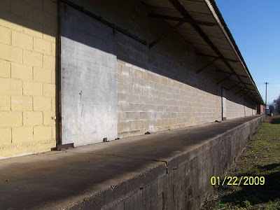
I couldn't check out the front of these buildings because of the one way traffic on S.Railroad. How I missed the long cinder block building coming up S.RR Ave., I haven't a clue, unless, I remember, there was no place to park due to the construction activities and I figured I'd get it later. Later doesn't always work. I think the red brick building on down the line is the Dezauche and Son Building. I've just confirmed it, it is. I'm glad there will be no controversy over that. That loading ramp on the cinder block building is quite something. And, I know you, as I, regard the picture as one of the best. You may remain seated.
I was done. I did want to catch the exciting exit of the Southern Pacific as it left Opelousas, so I carefully watched the GPS as I rode south on 182.
I stopped where the rails crossed, the old community of Vetin. Had there been a station here?
This is looking east toward I-49. As seen on the map, the rails bend from this point and parallel the interstate going south. Could the interstate planners have recognized what an intelligent choice the SP had made choosing this route? I'm sure that was taken into consideration. Government often looks to private business for innovative ideas, having few themselves.
Looking back toward Opelousas, someone had marred the memory of the right of way with a junk car. I see that all the time and have been tempted to address this abomination with the land owners.
What is left at Vetin is this. Put Vetin on you next vacation route. Not only can you enjoy these Cajun delicacies, you can also view the old right of way. During this time of economic crisis, having destinations with multiple points of interest is the way to go.
Below Vetin, I attempted to visit the lost community of Naka. Did it have a station? A large subdivision, one that I would not have escaped from without the GPS, had consumed whatever had been there, and almost, me.
At Shuteston, I left 182 and headed east on 178 to Muscadine Road.
Muscadine follows the SP north. Where you see "Pershing" is where the line is and where I turned north on this beautiful back road. The grade is easily seen as you enter the road.
Check out this grade!
This is the coulee it crossed!
Check out how high the fill had to be!
I knew I was in a treasure chest of railroad artifacts if I'd just look closely. I dismounted. A crazed chihuahua barked uncontrollably as I poked around. Wham there it was, my reward, a block of cement with studs protruding. It was obviously a part of the trestle. I attempted to load it onto the bike. I'll have to get Al to help me next time. I might also think about doing some ab aerobics. Some butt aerobics might be helpful, also!
Beaming with my future prize in mind, I headed to Sunset to close this one out. Sunset if a very neat little town which sports some very tangible relics from the railroad days.
Coming into town on 178, the Depot Lumber Yard has a fine old building preserved there, on the old bed. The lumber yard also had a spur, as seen on the map. Look above La.93.
Where you see "Sunset" written, is where the next pictures were taken. As you can see from my tracks, I explored back into the neighborhoods once again. I must admit I became a little nervous. I found nothing worth a stop to shoot and did not want to become a target myself since Sunset has a few societal issues.
Adjoining the rails was this old warehouse.
And this old store.
This is looking toward Carencro and Lafayette. I'd cut it off here and head on home.
That's it.

.jpg)
.jpg)
.jpg)
.jpg)
.jpg)
.jpg)

.jpg)
.jpg)
.jpg)
.jpg)
.jpg)
.jpg)

.jpg)
.jpg)
.jpg)
.jpg)
.jpg)

.jpg)

.jpg)
.jpg)
.jpg)
.jpg)
.jpg)
.jpg)
.jpg)
.jpg)
.jpg)
.jpg)
.jpg)
.jpg)
.jpg)
.jpg)
.jpg)

.jpg)

.jpg)
.jpg)
.jpg)
.jpg)
.jpg)
.jpg)
.jpg)

_(500_x_450)_(500_x_450).jpg)
_(500_x_450)_(500_x_450).jpg)
_(500_x_450)_(500_x_450).jpg)

.jpg)
.jpg)
.jpg)
.jpg)
.jpg)

.jpg)
.jpg)
.jpg)
.jpg)