Honestly, I thought this was going to be about the Southern Pacific's route between New Orleans and Lafayette, Louisiana. I've come to learn it is really about the New Orleans, Opelousas, and Great Western Railroad, before the SP, surprise. Near an old rail bridge across Bayou LaFourche, I found this historical marker mentioning a battle during the Civil War. It spoke of the railroad. Prior to railroads guiding me around, the Civil War had. Here my interests converged. The result of such an on site epiphany is usually a lot of research. I'll touch on a few of the highlights on this page.
I've wondered what that NOO&GW was all about.
I've wondered what that NOO&GW was all about.
The story starts on the West Bank of Greater New Orleans. New Orleanians use points on the map a lot in their location descriptions, it helps as the area is confusing directionally. There is the "Northshore", "Southshore", "Uptown", "Downtown", "Down the Bayou", lots of "Uppers and Lower's" and one real important one which isn't a direction but signifies one, "From the Parish", where they say "Slap yo Mama" a lot and you are "Dawlin" whether you want to be or not.
As I was saying, the story starts from the West Bank.
This from SP's pamphlet.
Algiers is on the West Bank.
Let me add a personal note right here. I spent 3 years as a
very young kid riding from Houma to New Orleans on US 90.
I knew about the rails on the Huey P. I never had an idea
of their significance. I'm glad I'm figuring it out and I hope
my excitement is contagious.
This is from some book on Algiers.


Below is a picture from the 1850's in Algiers. The shops
maybe behind it. Notice that there are 2 trains.

A little added history of the railroad and a review of what's been posted.
The New Orleans, Opelousas and Great Western Railroad (NOO&GW) was chartered in 1852. Construction began at Algiers, across the Mississippi River from New Orleans, in late 1852. By 1857, the track had reached Brashear (now Morgan City) on Berwick Bay, and this remained the end of the line for over 20 years. The NOO&GW was built to the "Texas gauge" of 5 ft 6 in (1,676 mm), the only such railroad in the New Orleans area to use that gauge; the line was converted to standard gauge in 1872.
This article is being edited.

This is a picture off of one of the company's bonds.The railroad was stuck in Morgan City
because of the lack of funds, possibly. Bonds were sold to help raise money.

"In 1869, steamship operator Charles Morgan bought the NOO&GW and began operating it as owner. In 1878 he organized his railroad property as Morgan's Louisiana and Texas Railroad and Steamship Company, and it eventually became part of the Southern Pacific Company's main line".
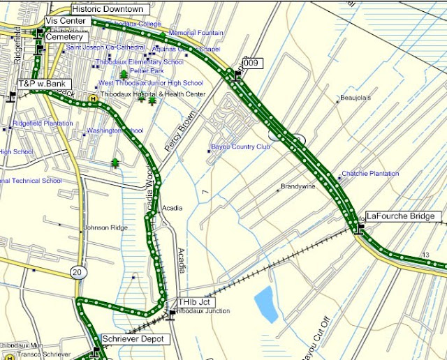
I know a lot of historical text is hard to stomach in large lumps without some pictures. I haven't done the photo shots between Algiers and Raceland yet, so the track maps will have to do until then. {I now have the shots and they will be added as soon as Christmas is over}They will at least give you an idea about where I'm speaking . My ride came from the west. The rails were built from the east. I've chosen to go with them and fill in this page later. Here are the maps. They are cutups taken from the SP maps that go with the trip. They were made prior to the Huey P. Long bridge being built. The HPL bridge rails crossing the river measure over four miles, at the time a world's record.
I will add a link to You Tube trip over the bridge here soon.
I will add a link to You Tube trip over the bridge here soon.
The red arrow points to the eventual location of the rail ferry.
You can see the location of Algiers on the right and the large
"yard" associated with the railroad. The green line are the rails
going west. Shortly, we'll be taking that trip.

The green line is US 90 this time. The orange is the NOO&SW.
I probably should have used a topographic map. This area is
very swampy.

Below, US 90 and the railroad remained the same colors.
The red arrow points to LaFourche, important for the CW battle
that occurred there and the bridge across Bayou LaFourche
you'll get to see if you hang tough. Remember, these rides are
not solely about the rails, but the land and history they ran through
and to which they contributed. This ride report is going to be a very
long one. And there's more, the branches . The purple lines going south,
I think, were eventual Southern Pacific rails. The purple one going north
from Thibodaux was the Texas and Pacific/Missouri Pacific.
and the red one going north from Thibodaux were SP,
but that's another story which I've lightly covered in the "Bayou Lafourche
Reconnaissance" ride (not yet updated or posted). You can verify the rail owners there.
Reconnaissance" ride (not yet updated or posted). You can verify the rail owners there.

Again the RR and US 90 retain their pigmentation.
The red arrow points to the end of the line until the mid 1870's and Mr. Morgan's
home for a while, thus Morgan City.


Though I don't have the date on this map, I see it as a proposed
route since the crops were dated as "1853" and we know that
the railroad was stuck in Morgan City until at least the 1870's. I have
guessed 1873, or later.
The red arrow is Opleousas, La. Gold is Vermillionville/Lafayette.
Green is New Iberia. Purple is Franklin. Blue is Berwick/
Morgan City was the end of the line, at least on this page.

I needto get you to Morgan City so you can place this next
story from the Civil War. Here is an early ride report on the
railroad. This was submitted by some Yankee to a Yankee paper, the NYT.
Of course, as today, bias was the name of the game and no
Confederate slant was written.
One of the passengers was Gen. Weitzel, locally know
as Weasel Weitzel. I wish I had a picture to make my point.
NEW-ORLEANS, Friday, Aug. 14, 1863.In my last I mentioned that the New-Orleans, Opelousas and Great Western Railroad was again ready for travel, and an hour after my letter was mailed on board the Columbia, yesterday morning, I found myself, by invitation, at the Algiers Depot, one of a select party to make the first excursion trip, which was of importance enough to merit a description.......The train consisted of only one passenger car, a baggage car and an engine, the latter gaily floating the American flag. The party got together by the indefatigable Captain E.A. Morse, A.Q.M. and Superintendent of of the road -- to whom, indeed, we were indebted for the whole day's pleasure -- consisted of Brig.-Gen. GOLFREY WEITZEL, F.F.F.F, (which is understood among the initiated here as meaning "first in fight, fun or frolic.") Capt. E.A. Morse, Capt. J.W. McClure, Quartermaster; Maj. H.O. Brigham, Chief Paymaster of the Department; Maj. Nicholas Vedder, Paymaster; Maj. H.K. Lawrence, Paymaster; Capt. Chas. S. Bulkley, Superintendent of Military Telegraph; Capt. R.P. Dunham, Aid-de-Camp of Gen. Banks' Staff; Capt. A.K. Bowles, of Gen. Shepley's Staff; Lieut. E.E. Graves, of Gen. Weitzel's Staff; Lieut. H.B. Fitch, of Gen. Weitzel's Staff; Ensign Sidney S. Beck, of the gunboat Sciota; C.W. Greene, Assistant Superintendent of the road. The press was represented by Mr. Ripley, of the New-York World; Mr. Fairfax, of the New-Orleans Era, and your humble servant.By 10 o'clock the whole of the invited guests had arrived at the Algiers Depot, and a few minutes afterward the engine was whirling along one of the gladdest parties I ever saw assembled. The occasion was one of jubilee; the right men had been got together to celebrate it, -- the weather was lovely though intensely hot, and I don't know but that the latter qualification made ten times more enjoyable the piles of iced luxuries with which Capt. MORSE -- that prince of caterers -- had so bountifully supplied us. No wonder if time flew among us rapidly as the champagne corks that kept up their incessant volleys, or the screaming and bounding engine that seemed to have entered thoroughly into the sport. Such a scene of genial and untrammeled enjoyment I have seldom entered into since my schoolboy days, and it was all the more relis[???]able because partaken with men who have ever been -- and are yet -- ready, at a moment's notice, to forget all levity and serve their country at the cannon's mouth. With the brave WEITZEL as temporary "Lord of misrule," what man present could have dared or even wished to play the stoic?STATE OF THE ROAD.But our merriment did not prevent us from attending to the main object of the trip, and examination of the works on the road, and these were really of a nature to excite not only the admiration but astonishment of all present. As we successively crossed the bridges over the Bayous Alemand, Lafourche, Boeuf and Ramons -- stopping at each to examine them -- it seemed scarcely credible that so enormous an amount of labor could have been performed in so short a time.Having, in my last letter, given you the statistics of these bridges, it is unnecessary to repeat them here, but will merely state that in thirteen days, Capt. MORSE, with the aid of his assistant, Mr. C.W. GREENE, of whom he speaks most highly, has succeeded in building a total of 1,675 feet of very heavy bridging, and some thirty culverts; the lumber for all these bridges having to be hauled to the mills, sawed and prepared. One or two of these bridges are built upon, to me, an entirely new and most efficient plan -- and they all, and indeed the whole road, are now in a far more substantial condition than before the rebels paid us this last visit. We are therefore all the better for the little house-cleaning they forced upon us.BRASHEAR CITY.We arrived here a little before 1 o'clock, having made the quickest running time ever attempted on the road. At Brashear City {Morgan City} but for the fact of having heard and read so, and but for the two or three cannon shots pointed out to me at the depot building, the telegraph station, &c., I could not have supposed that the town had gone out of and been won back to our possession since I was last there, everything seemed so precisely as I had left it.
May I respond? Well, not exactly like you left it. Taylor's Navy (rafts and small boats) completely
outfitted his little army with all of the Yankee's supplies.
An apology:
Sorry, I lost the source of the info below.
All of the New Orleans based railroads had been seized by the Federals. In 1862, shortly after
the capture of New Orleans, a company of Confederate Rangers from St. Martinville captured the train at Bayou Boeuf (near Amelia). The Rangers steamed the train as far as Jefferson Station, near Avondale, tore up a portion of the tracks and returned to Berwick's Bay, burning bridges behind them. (this writer uses the term "Ranger" as if they were an organized bunch. I don't hink they were. I don't think there was much organization until General Taylor rode in.)
By July, the Yankees resumed control of the eastern portion of the rail line and for nearly four months the railroad operated a unique kind of joint control. The union forces operated between Algiers and Des Allemands, while the Confederates operated from Des Allemands to Berwick's Bay. The black line reflects the Rebel's portion, the red the Yankee's. My folks got stuffed crabs in Des Allemonds.
Germans settled here, thus the name.
Germans settled here, thus the name.

In November the federals sent out a train with cannons mounted on flat cars. They captured the entire rail line. The Confederates retreated, but not before destroying buildings and most of everything else.
Below is an excerpt from somewhere? Oh, the SP, cool.

Shame on Lafayette.
That administration was joined by another when Lafayette destroyed one more
monument to railroading, Old 748 that once sat in a city park. I remember it.
For the whole story of the battles that occurred around the railroad, CLICK HERE .
.jpg)
This is the Lafourche rail bridge, not the original.
That is La.308 which shadows La.1 on the opposite side of the bayou.
That is La.308 which shadows La.1 on the opposite side of the bayou.
.jpg)
This was the second page of my trying to fill in this old write with my pictures and commentary.
On this page I've chosen to leave most of the ancient history behind and jump right into the trip.
I found this report on line. I haven't read it yet, so I'll be taking notes and dissecting it as we go along. It is a USGS (US Geological Survey) report. What I found interesting is the railroad aspect of it. The geological stuff will bore you to tears. It was written in the 1930's which makes it appealing to me. Knowing that there is something older than myself is comforting. So, what I'm going to do is cut it down to what I find palatable. I'll include the link to the full volume so you can read the entire thing if you want. I will augment as I can with pithy comments and a trillion pictures.
Below are the writer's words. What I add will be in brackets.
It's easier than hitting the quote button for every paragraph.
It's easier than hitting the quote button for every paragraph.
Of note, the write starts in Algiers on the West Bank, Greater New Orleans. There was no Huey P. Long dual purpose bridge there at the time of this writing. In 1935 there would be. Though not a part of this trip, here she is, a true wonder of the world and it was somewhat duplicated in Baton Rouge a few years later.
_(320_x_240).jpg)
Below the author speaks of Jefferson. It is the location
of Oxchner Hospital and where the "SP 745" is kept.
Now that's another story.


Here he goes. Imagine a 1930's railroad documentary film.
HISTORY OF THE RAILROAD
The railroad from New Orleans to Los Angeles is part of an extensive system with many individual members, of which the Southern Pacific Co. owns all or very nearly all of the capital stock. The line from Algiers, La. to Lafayette, La., now known as Morgan's Louisiana & Texas Railroad & Steamship Co. was incorporated in 1852 as the New Orleans, Opelousas & Great Western Railroad Co. It reached Morgan City (Brashear ) in 1857 and Lafayette in 1880. It was operated by the United States during the Civil War and owned by Charles Morgan from 1870 to1878. (the year of his death)
{This speaks of west of Lafayette, more than I am willing to deal with at this time.)}
The Louisiana & Western Railroad Co. was built from Lafayette to the Sabine River in 1881, and the Texas & New Orleans Railroad Co. was constructed from Orange to Sabine River (Echo) in 1878-81. The latter was operated as part of the Louisiana Western Railroad until 1900. The Sabine & Galveston Bay Railroad & Lumber Co., later the Texas & New Orleans Railroad Co., built a line from Houston to Liberty in 1856-60 and from Orange to Liberty in 1859-60. It was dismantled by the Confederates in 1865 and restored in 1870.
{The write goes on to explain each stretch west. What follows are general statements and descriptions.}
The Southern Pacific Railroad from New Orleans to Los Angeles, a distance of about 2,000 miles, passes through a region exhibiting a great variety of geographic and industrial conditions. The climate, especially the amount of precipitation, is the most influential factor in causing this variety.
The low Coastal Plain of southern Louisiana and eastern Texas, with ample rainfall and thick rich soils, is a province distinct in configuration, human occupations, and products. There are extensive swamps, prairies, and wooded areas, but a large part of the land is under cultivation, with sugarcane, cotton, and rice as the principal crops. The streams are wide and slow, the winter climate is mild, and the summer heat is tempered by breezes from the Gulf of Mexico. Flourishing towns occur at short intervals, and some of them are growing rapidly. The entire region is underlain by a great thickness of sand and clay of alluvial origin.
Figures given on mileposts in Louisiana indicate miles from Algiers, a Southern Pacific freight terminal on the south bank of the Mississippi River opposite New Orleans; they are about 1-1/2 miles less than the distance from the Union Station, New Orleans.
{I'm cutting the flowery description here.}
{The trip begins. Note the mention of the ferry and the proposed Huey P. Long Bridge.}
{This ferry was regarded as a "temporary expedient".}
Leaving the Union Station, New Orleans, the Southern Pacific train uses the tracks of the Illinois Central Railroad as far as Harahan Junction, a switch station on the north side of the Mississippi River. Thence the line crosses the river flat in a southerly direction and in 2 miles reaches the levee, over which it passes on an incline. Here on the bank of the Mississippi the entire train, divided in sections, is placed on a huge steel barge (The Mastodon) to be ferried across the swift current to Avondale, on the southwest bank, a distance of nearly a mile. The floats are adjustable for different stages of the river, for there is considerable variation in the water level consequent on floods and droughts.


This is the Mastodon.
This was the SP track and yard layout on Algiers Point.
I believe the article said it was built in the late 1800's and
torn town in the 1950's. I see large buildings where the
green arrows point. And, I see some I missed.

And the guys at the roundhouse.


CLICK HERE for the Algiers site.
Things were not always good.


Let's continue:
Avondale.
Elevation 8 feet.
New Orleans 13 miles.
{Reminder: these are distances from Algiers, West Bank.}
At Avondale, not far south of the ferry, the train reaches the Southern Pacific tracks coming from Algiers, the terminal on the south side of the river opposite New Orleans, used only for freight. The land is low behind the levee, and most of it is too swampy for economical cultivation. In this area will be noted many cypress trees, water hyacinths, and other plants typical of the swamps and lowlands of the South. In wet places there are scattered palmettos with their clusters of fan-shaped leaves. Most of the larger trees are festooned with the parasitic Spanish moss.
{Spanish Moss is not parasitic}
Des Allemands.
Elevation 9 feet.
Population 400.
New Orleans 33 miles.
To the small local settlement at Boutte the railroad proceeds along the natural embankment of the river and then follows a low ridge through the woodlands to Des Allemands, where Bayou des Allemands is crossed. This name is derived from a small settlement of Germans founded in colonial days, but the population now consists mostly of people of French origin living in primitive dwellings along the water's edge. For many years there was a sawmill here which cut cypress lumber from the adjoining swamp lands; now the supply of this material is practically exhausted, and the main resources are fishing, crabbing, and the trapping of muskrat and other fur-bearing animals.

{I'm inserting a borrowed picture here as filler until I can take my own, next trip.
Exploring Des Allemands and Boutee, along with Paradis, will be something new)
(Update: it was and I'll do a link or insert the shots in this one asap!)
(Update: it was and I'll do a link or insert the shots in this one asap!)

{I'm inserting a little Civil War here)

In midsummer the water bodies in this region are spangled with a beautiful growth of the purple flowers of the water hyacinth.
{Some may not appreciate the plant as you do, sir.}
Bayou des Allemands empties into Barataria Bay, an inlet of the Gulf of Mexico, which was at one time the headquarters of the pirate Jean Lafette.
{Jean would make you walk the plank for spelling his name incorrectly.)
Formerly some of the district about Des Allemands was reclaimed for agriculture by ditching and pumping. Now the first signs of extensive cultivation begin near Raceland Junction, where there are fields of cane supplying the large sugar refinery at Raceland, a short distance south. This refinery, which presses about 150,000 tons of cane a season, draws part of its supply from more distant sources, some of it brought down the near-by Bayou Lafourche in barges. An interesting industrial development in the sugar industry in Louisiana is the utilization of the cane residue (bagasse) after the sugar-bearing juice has been pressed out. This material compressed into bales is shipped from many refineries to a large factory at Gretna, across the river from New Orleans, where it is pressed into sheets of building board known as celotex. In some of the cane fields at Raceland experiments are in progress to ascertain the results of using Chilean nitrates as fertilizer. Bowie siding is in the midst of cane fields, and there is a sugar refinery not far south of it.
The refinery is at Raceland.

Between La.1 and La.308 is Bayou LaFourche.
{The walls of our home in Houma were made of celotex
Since he mentions Bowie and Raceland, lets look around.
Bowie was my reason for coming here. It was a red cypress lumber
mill town. It was out at the end of that road. The land tilts here away
from Bayou Lafourche and toward Des Alemans.}
.jpg)

{Panning to the south, the sugar mill comes into view.}
.jpg)
{It is a big one.}
.jpg)
{Raceland Sugar, 1892. I don't know if Dixie Crystals are
still marketed.}
.jpg)
{This the "big house" on the property.}

{Next, I followed the spur into Raceland. If you want to visit
the location of the depot, just ask where the post office is.}
.jpg)
{Places where depots were seem to leave a scar. Some
not only physically. They were the center of many communities.}
.jpg)
{Beauty is in the eye of the beholder.}
.jpg)
{The only contemporary building was this one. A passerby starred as I took its picture. }
.jpg)
{I went back out to the sugar mill to check what rails went where.}

{These tanker cars, below, are sitting in the bend turning south near the depot.
Notice "Bowie" and the siding mentioned. I should have worked
harder at getting back there, but it looked private? The mill is probably
closer to town, being, in reality, inside that bend between "Depot and "3199".
I've walked around on the grounds of Valentine Mill, at the end of the
spur which goes down the east bank of the bayou and had no idea
of the weight of the moment. Next time back I won't miss as much.}
{Here's Valentine Sugar Mill (rip). (map above)}

{Here are the cars in the Valentine spur curve going south. The
track going straight, west, would go to the Raceland depot, rip.
.jpg)
{Then he goes into a rant about Jean Lafitte but doesn't mention his name at first. Raceland Junction is where my last trip ended. This write will feature more of my pictures from this point on. I include this spiel because there is a section of the Jean Lafitte Cultural Center at Thibodaux. I was too worn out and short on time to go in. That happens way too often. Ok, here he goes. I really don't understand his use of "notorious person".
Was this the beginning of Political Correctness ?
Was this the beginning of Political Correctness ?
This notorious person, {LaFitte} about whom center hundreds of colorful legends of this region, ran a blacksmith shop in New Orleans in the early days of the nineteenth century (at 810 Chartres Street, just off Canal Street). At this time privateersmen in the Caribbean Sea were preying upon the vessels of countries that were hostile to the countries that hired them, and Lafitte became the agent through whom they disposed of the captured cargoes. In time he became the leader of a fleet of licensed privateersmen and established a fortified post on Barataria Bay. He trafficked extensively in slaves, at one time selling 450 negroes {small "N"?) at public auction. The proceeds of these sales and his piratical booty buried for safe-keeping are still the object of treasure hunts in the bayou country. For his loyalty to the American forces in the War of 1812, his earlier outlawry was overlooked. He resumed his piracy in 1817 and moved his headquarters from Barataria Bay to Galveston Bay, where his fortifications continued until he was driven out in 1821. Apparently he was finally lost at sea.
{Now he's back to his present.}
The abrupt change in agricultural conditions at Raceland is due to the presence of a ridge of alluvium built up by sediments spread by the overflow of Bayou Lafourche. Alluvial uplands of this character are of great economic importance in many parts of the great valley of the Mississippi, for although not wide they have rich soils and are sufficiently high to afford good drainage, roadways, and places for settlement. On them are the principal farm lands in this part of Louisiana. The mound of Bayou Lafourche extends from the Mississippi River at Donaldsonville nearly to the Gulf of Mexico, a length of more than 100 miles. Its height for most of the distance is only about 15 feet, and its width is from 3 to 4 miles.
Bayou Lafourche is the narrow stream crossed by the railroad just beyond Lafourche station.
{A tidbit of historical info gleamed from above. Lafourche Station was on the east bank of the bayou. Want to see the bridge? I have pictures, senior. I had come down La.1 from Thibodaux on the west bank. I saw the over pass. I stopped at a gorgeous old house that was a bit away from the tracks as it offered the only safe parking. I could not get a good shot from the shore as it was too thick with brush,
so I did what I do and climbed the fill. }
so I did what I do and climbed the fill. }
.jpg)
.jpg)
.jpg)
This was not the bridge in the Civil war, but the location.
.jpg)
Originally this bayou was an outlet for part of the flow of the Mississippi River and was extensively utilized by freight boats, but to avoid the floods that occasionally came down the bayou, the connection at Donaldsonville was dammed off in 1903, and the navigability of Bayou Lafourche was greatly reduced. However, it is still used for traffic into the Mississippi River, with which it is connected by locks, and part of its lower course will be followed by the Intracoastal Waterway now projected across the lowlands, some distance south of the Southern Pacific lines.
{Here's a look at what the bridge crossed.}
.jpg)
{Here's the Civil War historical marker.}
.jpg)
History insert:


{That's the other side's account, by the way. The "4 mile
away depot" was probably Thibodaux.}
Let's move on.
Let's move on.
Lafourche.
Elevation 25 feet.
Population 60.*
New Orleans 53 miles.
This is what I found north of LaFourche Crossing.
.jpg)
.jpg)
The Davenport is in front, the Plymouth is to the rear.
.jpg)
The Dav.....
.jpg)
The Plym.......
.jpg)
Visitors were everywhere and it was a weekday. Nice place.
It is on La.308, south of Thibodaux. Laurel Valley Store (Laurel Plantation)
{Last check, I think we cleared the rail bridge over the bayou.
The writer seems in a hurry. I think he wrote way too much
about the flora and geology of the region and now he feels pressed.
I know the feeling.
Green is me on my last route through here. I took a side trip
to Thibodaux.}
The reference to "T&P w.Bank" on the map is wrong. There was
no T&P rails on west bank until Nepoleonville and above.
My bet is that the T&P had rights on the SP rails from Thibodaux down to
Thibodaux Jct.
My bet is that the T&P had rights on the SP rails from Thibodaux down to
Thibodaux Jct.

{The green line is my route.}
{Below is the author's homage to Thibodaux.}
Three miles northwest of Lafourche Crossing, but not visible from the railroad, is the town of Thibodaux (population 4,400), an old village of French origin, with important agricultural and commercial interests.
{Thibodaux is Louisiana's best kept secret. Or, at least La. kept it a secret from me for a long time. I'll use a tourist pamphlet word, "charming". If you are "charmed" by the anviance of the French Quarter's history and beauty, but not it's sordid Bourbon St. profile, Thibodaux's old town is your ticket. Plus, it sits on a lazy bayou and has a Jean Lafitte Cultural Center extension very close to where the Texas & Pacific RR crossed the bayou and the SP went to a mill. I am impressed with Thibodaux.}
The author, I surmise, was solely focused on the Southern Pacific's main route. Thibodaux was a Southern Pacific and Texas & Pacific town. I don't understand the slight by way of only 3 lines he gave to this important community. Honestly, I have not done her justice either, having only made 2 short visits there, each with the promise that I'd be back. And, I will when I get those pictures around the West Bank. The best link I can offer can be accessed by CLICKING HERE.
Look at that link and then come back and take a look at my few pictures of town.}
.jpg)
{Above as seen from the Jean LaFitte Museum. The good
stuff is very central.}

{French Quarter? No, Thibodaux.}

{Mayberry?}
.jpg)
{No, the hotel across from the courthouse where Huey P.
probably stayed while courting his wife.}
.jpg)
{Important?}
.jpg)
{Yes}

{Historic?}
.jpg)
{I'd say so.}
.jpg)
{But, still Old South stately.}

{You bet.}


{And one of the best cemetery shots I've taken.}
.jpg)
{You should cleck the map below. I just had to change it.
The S&P had a branch going north from
Thibodaux Jct. It was called the Napoleonville Branch as it ended
approximately at Napoleonville. I had thought both sides of the bayou
were Texas & Pacific. No, the T&P came south from
Donaldsonville and took the bridge east over the bayou at Napoleonville.
I have a shot of that bridge which is now a pedestrian walk. Then the
T&P dove south stopping at the sugar mills, ending up at Thibodaux
where it jumped the bayou again. I had a pitiful picture of the
Thibodaux station at one time. I may have deleted it because it
was so bad. Feeling despondent, I found a reference to it in a La.GS book,
"The station is on the north side of Bayou La Fourche
in the lot just west of the house of Judge Beattie. This house is
opposite the bridge from Thibodaux and near the Texas and Pacific
depot. }
{The depot was on the east side of the bayou which was
considered T&P country.}
I also found another write that describes the SP Napoleonville branch.
Since I've stirred this ant bed. I'll show the pictures I have . The
first is the T&P bridge at Napoleonville.}

Below is Napoleonville explained. Green is T&P, red is SP.
Where you see "1" is the bridge above. The black arrow
points to where the SP and T&P may have met way way back.
Unfortunately, the ride visiting both sides of the bayou and
showing the remnants of those rails and the mills they visited
is sleeping in my computer.
(A future ride would almost make the argument for a meeting.)
(A future ride would almost make the argument for a meeting.)

Below Napoleonville, at Madewood, or thereabouts, there was this
in the water. No telling what it was?

.
On that trip, I exited town on the east, going down La.1.

{Brown is the T&P. Light green is the SP (above).
Dark green is me.} Again "T&P w.Bank" is incorrect.
It should read "SP w.Bank".
When I came into town the last time. I looked for old
industry that might have been served by the RR. Most
was gone, I presume. Here was Louisiana Cane Mfg. Inc.
It was southwest of downtown.
.jpg)
It was getting hot and the Lafitte Historical Museum
was a nice break, though like I said, I stayed in the parking lot.
.jpg)
This is the view looking upstream from their river walk.
That may be a warehouse previously serviced by the
T&P over there. Why didn't I check the other side?
Oh, I still needed to get to Bowie, LaFourche and Raceland.
On this ride I had aimed high at the West Bank but I
started feeling weak at 3:30 in Thibodaux. I knew US 90
would have to be the ticket home.
.jpg)
Schriever.
Elevation 17 feet.
Population 50.*
New Orleans 56 miles.
That's next.
.jpg)
But, we'll have to go though this to get there.
Suggested Reading Click Here.
That's the write on the SP I found.
{Leaving Thibodaux, it's a short 4 miles down to Schriever.}
{ Update note: I recently rode back over to Raceland and resumed following the tracks east.
I knew this was going to be a long one, and maybe the last one in this area for a while, so I was going to be as thorough as possible with the time I had left after the long trip over. Coming up La.20, I stopped for a break and while out by the tracks I saw a light approaching. I laughed as I assumed the place to be private. Private places are scarce on the road these days. Anyway, here comes this light. Mercy me, it was the the Sunset Limited. I stumbled down the embankment and ran to Mz Guzzi, vaulted upon her back and spurred her hard. Evidently, the train had been given the reigns, also. I couldn't catch her without asking for a ticket. I am the guy that will get one as I'm a ticket magnet, so proven in my younger years. At Schriever, she stopped at the depot. Passengers were disembarking. Instead of stopping and zooming in the camera, I attempted to get closer to catch an engine shot back to the old depot. That would have been a classic. As the last passenger's foot hit the ground, she pulled out of the station. No shot. Ya can't always get what ya want, but............and we all know the rest of that line. Nevertheless, I would get what I needed all down the line. I would later take a special trip to Schriever and meet the Sunset Limited coming in from New Orleans.
I knew this was going to be a long one, and maybe the last one in this area for a while, so I was going to be as thorough as possible with the time I had left after the long trip over. Coming up La.20, I stopped for a break and while out by the tracks I saw a light approaching. I laughed as I assumed the place to be private. Private places are scarce on the road these days. Anyway, here comes this light. Mercy me, it was the the Sunset Limited. I stumbled down the embankment and ran to Mz Guzzi, vaulted upon her back and spurred her hard. Evidently, the train had been given the reigns, also. I couldn't catch her without asking for a ticket. I am the guy that will get one as I'm a ticket magnet, so proven in my younger years. At Schriever, she stopped at the depot. Passengers were disembarking. Instead of stopping and zooming in the camera, I attempted to get closer to catch an engine shot back to the old depot. That would have been a classic. As the last passenger's foot hit the ground, she pulled out of the station. No shot. Ya can't always get what ya want, but............and we all know the rest of that line. Nevertheless, I would get what I needed all down the line. I would later take a special trip to Schriever and meet the Sunset Limited coming in from New Orleans.
.jpg)
.jpg)
{Its location in relation to Thibodaux Junction.

{Schriever was the axle for all the short branches that
emanated from it. Houma was one.}

{Lockport was another.}

{Napoleonville was another.
I'll have to find that one in my stash.}
{And, some old business from the last page,
Thibodaux was not named for Boudreaux's friend.}

{He was the Captain of the LaFourche Volunteers who
fought alongside General Jackson and Jean Lafitte at the
Battle of New Orleans. The dude was a dude.}
{And, I found this picture of an old bridge spanning the bayou
at Thibodaux.}

{I don't think it would have supported rail traffic. But, the T&P
had to jump the bayou some way, and my trusty Garvin Topo
said it did.}
{Ah, and a teaser to go back and reread a prior page of this ride.
I have no idea why I inserted this picture of a train descending the Huey P.
at Bridge City, West Bank It was taken on the ride east from Raceland}
I have no idea why I inserted this picture of a train descending the Huey P.
at Bridge City, West Bank It was taken on the ride east from Raceland}

The Raceland to the East pictures will be forthcoming.
{Now, back to our 1930's tour director:}
An alluvial ridge extends southward along Bayou Terrebonne through Schriever, and another, extending along Black Bayou, is followed by a branch railroad to Houma.
{The author is not clear here. There was no SP railroad down Bayou Black which is west of Schriever at Gibson. The Houma branch dove due south from Schriever . It went along Quishi Bayou and Little Black Bayou into town. Back to his spiel.}
At this old town {Houma} there is a large sugar refinery and an extensive business in oysters and other gulf products. Much sugarcane is raised in this part of Louisiana, and formerly there were many small sugar refineries, some of which are still visible. {the smoke stacks were left} Potatoes have lately become an important product, and considerable corn is raised. Between the alluvial ridges the land is low and swampy, but in places it can be drained by pumping; one notable reclaimed area of this kind southwest of Raceland is yielding large crops of corn. In the swamps cypress, tupelo gum, and other trees flourish. Lumbering has long been an active industry, but many years of vigorous lumbering has greatly reduced the amount of timber available.
{The rape of the red cypress forest is evident. Unlike the reforestation of pine country, when it was gone, it was gone, thanks to mills like Bowie. Replacing 400 year cypress is like replacing the Sequoias.}
There was formerly a sawmill at Chacaholua, and at Donner a large mill is in operation on logs brought by rail and in "booms" rafted through the great system of waterways traversing the lowlands to the north.
Donner.
Elevation 11 feet.
Population 900.*
New Orleans 65 miles.
Donner is in the large lowland area that was covered by the great flood of the Mississippi River in 1927, when in the lower places the water was from 6 to 10 feet deep for several months. The flooded district extended far to the north and northwest over the lake region and the country traversed by the Grand and Atchafalaya Rivers. The bayou ridges described above (p. 14) were not covered, but the water extended far up their slopes. During the flood thousands of residents on the lower lands were driven out by the water, and there was considerable loss of crops and effects. The railroad embankment near Donner was slightly submerged, and parts of it had to be protected from the flood waters. In this region the roads are surfaced with oyster shells, which make an admirable road metal for light traffic. Shells are also burned as a source of lime.
{This, I believe, is a great old "tourist court" at Donner.
Donner and Chacaholua blend together. I'm assuming
there was a depot here and that the court serviced those
passengers. It may have been a resort for those interested
in hunting and fishing. The larger building is a full service
gas station of old. It is now a tire repair shop, opened only
on certain days. This area was remote.}
.jpg)
These places are on the rail side of the highway. Whether
they predate the Great Flood, I can't say.
.jpg)
I'm going to dedicate this page to catching us all up.
I need to get the forgotten maps posted. I'm a mappy and I know that there are a few others out there. These are old.

This the "Catch Up" Portion of the Article
Something's drive me crazy. I do all the leg work finding stuff
and then don't write down an itinerary or even enter way-
points into the GPS. I go back to the maps and realize I forgot
to check out my all imported points of interest, like the
location of the old train ferry. That's a 300 mile mistake.
I was there and blew it. The river bent to meet the road and me.
How easy would that have been? I will rationalize that the
spot was probably deep behind some high fence, accessible
only at night with the right Mission Impossible gear, which
I have used and am not afraid to use again.
Despite my shortfalls, fate has not given up on me and she does
supply. I found a road to the beginning of the rail ramp to the
Huey P.Long dual purpose bridge over the Mississippi River.
There was no NO TRESPASSING sign and I was completely
unmolested. That would have been enough. The kicker is that
there was a train in perfect position for a shot, stopped on the bridge.
I was shaking knowing something would foul up, the camera would
die, the train would move before I could set up, like at Schriever, something.
But, no. It stayed right in that place and posed.

What purpose this little building serves I can only guess.
Actually, I may have figured it out as a control for a yard which
is or was past the entrance to the bridge.
Or, possibly it serves no purpose now. No one came out
and yelled at me which is almost an expected occurrence.
You can see the "keep out" sign's edge. At this point I
realized I was OK and not in jeopardy not having
passed some objectionable point. If it was the bridge keeper's
house. He surely must stand in high regard amongst fellow bridge keepers.

The long gone ferry was at Avondale.

I know you are all rushing to your dictionaries. Stop.
The core word is mode. All it means is that different ways
of transportation are used in the same journey, ie, trucks
and rails in this instance, possibly even water with the
river so close by, wouldn't you think.
Since Paradis is on this map I'll show you a little of the neighborhood.
Paradis is much more than its US 90 face.
Paradis is much more than its US 90 face.
That face still has a few classic buildings which have served this
important highway for a long time so I'm not diminishing that
area. But, back streets and back roads are my gig.
I haven't an idea of what this building was.
Evidence seems to say "warehouse"
Evidence seems to say "warehouse"

This is an old Episcopalian. My bet is it is very old, possibly
pre-Civil War. The lines are right. You must remember, this
is the Old Spanish Trail, or close to it. In Des Allemands the
actual location is noted. I can only say that there is so little
dry land at that point, the exact position of the old road can't
be far off.

Moving west along the railroad road, you come to this
gorgeous spot.

Across the rails was this one.

Check out the map.
"Yard 1" refers to the west entrance to the Intermodal Facility.
"HPL" is the Huey P. Long Bridge.
"Train on HPL" is where I shot the train on the HPL.
Notice, it's a long way from the water. The rail bridge is
4.5 miles long with a 1.5% grade. The top is flat unlike
most bridges that arc.

Below: Heading west. I had taken the river road back as
US 90 was making me crazy. Finally I figured I had escaped
the worst of it and rejoined the 4 lane. My ride in was
next to the rails. The ride back would be on the big
road, down and dirty and not near as fun.

Solid ground gets narrow after Schriever. There's only one way in and one way out, the old route of US 90. Des Allemands is an outpost town built along the alluvial overflow of Bayou Des Allemands. It is a true marsh / bayou town fit for any movie or book background. I really like the place. Maybe it's time to let our guide take over. As I have said before, imagine a 1930's documentary or maybe one of those movies your teacher showed in school when she had no lesson plan. When I was teaching, I became proficient in the operation of projectors and slide machines. Actually, I had to have one of the kids set them up. And, the { }'s denote my words since this is his article. I find quotation marks mundane and I figured you could deal with a little spicing up in this one.
{Hang on, his spiel gets energized}.
"September 1862 The town of Des Allemandes is the scene of numerous skirmishes resulting in capture of an entire detachment of Union soldiers on September 4. A Union train with sixty men ambushed at the Boutte station by a Confederate force of Louisiana militia and volunteers on September 4. The train escapes to New Orleans. Fourteen Union soldiers are killed and twenty-two wounded in the skirmish."
{Ah, I went looking all over Paradis for that historical marker. It was at Boutte."}
{OK Rosco, the floor is yours. Orange is US 90 (old) and green is the RR.}

Des Allemands.
Elevation 9 feet.
Population 400.*
New Orleans 33 miles.
To the small local settlement at Boutte the railroad proceeds along the natural embankment of the river and then follows a low ridge through the woodlands to Des Allemands, where Bayou des Allemands is crossed. This name is derived from a small settlement of Germans founded in colonial days, but the population now consists mostly of people of French origin living in primitive dwellings along the water's edge. For many years there was a sawmill here which cut cypress lumber from the adjoining swamp lands; now the supply of this material is practically exhausted, and the main resources are fishing, crabbing, and the trapping of muskrat and other fur-bearing animals.
{Primitive dwellings?, I hope that fella kept going before one of the dwellers caught him at the bar.}
In midsummer the water bodies in this region are spangled with a beautiful growth of the purple flowers of the water hyacinth. Bayou des Allemands empties into Barataria Bay, an inlet of the Gulf of Mexico, which was at one time the headquarters of the pirate Jean Lafette.{sp} Formerly some of the district about Des Allemands was reclaimed for agriculture by ditching and pumping. Now the first signs of extensive cultivation begin near Raceland Junction,
{Once again, he can't spell the name of a historic fig-your.}
{ See, it's almost an isthmus like Panama. You don't hear
that word much these days.}


{This is what the engineer sees if he has to get down off the engine.}

{If he walked over to the old US90 bridge, this would be his view.}

{If he fell down the fill, like I did, he'd see this.}

{If he looked at the below sea level underpass, this is what
he'd see.}

{If he looked at the street sign............}

{If he walked out to the old highway...........}

{He'd know he had left Ascension Parish and entered La.Fourche
and wondered what that "History Hunts" was and who the heck
is that "Steve" who deserved such a nice welcoming sign.}

{Then he'd look at the ugly new US 90 bridge and probably
think that it was ugly, too.}

{I'm going to cut Rosco short on this one. I have to make
up my mind how to approach the next set of towns. As I
have alluded, this route has been followed twice in the
very near past and written up in one form or another. I
have to get organized. The rest may be limited to a set of links.}
{Back to the book.}
Gibson.
Elevation 11 feet.
Population 60.*
New Orleans 67 miles.
{Back to me. Gibson sits at the intersection of La.182
and La.20, the road to Thibodaux. What the state now
calls 182 is old US 90. Renaming the road was wrong.
There's too much long term history associated with it to
make following the "trail", the OLD SPANISH TRAIL (OST),
difficult for future generations. Instead of naming it
stupidly, 182, why wasn't it called the OST, reverting
to its earlier name while creating a tourist attraction?
Because bureaucrats are dumb and don't give a .....}
{Here we are at the intersection. I'll let our narrator
run a few lines and then I'll come back because, though
he says that there is no significant structure here, there is stuff.
Extreme beauty is just a bit off the road, that is if you
like lazy bayous with shrimp boats tied to the banks
under sheets of Spanish moss and significant structures
if you use my gage? Ok, Bernie...}
Gibson is a small village on Black Bayou, a waterway of some importance. A quaint old church is about the only feature of special interest. Gibson was formerly an extensive lumber-milling community, drawing on the rich supplies, now mostly depleted, of cypress and other trees in the great swamp country to the north. This swamp vegetation is still a picturesque feature along the railroad in places, especially the drapery of Spanish moss on many of the trees.
Spanish moss is extensively utilized for making mattresses and other cushions at moss "gins" at many places. The moss is cured by moistening and airing to decompose the living portion, then dried, carefully worked to remove dirt, sticks, and other undesirable materials, and thoroughly washed.
{I feel obligated to stop here and and dredge my
lake of photos for local shots. I could hang out at the gas
station at Gibson and watch traffic, catch a few
passing trains and absorb the aun viance of the place.}
.jpg)
DL, still new.
.jpg)
The bridge turns to allow boat traffic through. At one
time a full time employee was required. What preceded
the 1946 bridge? Now there's a good question.
.jpg)

.jpg)
.jpg)
{What did you expect, "Johnny Lafitte's BB Marina"?}
.jpg)
{February in Louisiana. We have a great ice fishing season.}
.jpg)
{Mason du Masons}.
.jpg)
{Just what you'd expect to find nestled against a dark La.
bayou, a beer parlor. Someone really has a sense of humor.}
.jpg)
.jpg)
{ That's the railroad. You can see 20 and it taking off to Thibodaux
and US 90 headed south. There is no new US 90 on this map
which really makes it nice. The blue lines signify swamp}

{This is now. There is no swamp, no bayou, only sterile
"US 90". The railroad remains. Check out the road labeled
as "Old Spanish". Continue its curve to the next road and
I'll bet that's the old route. Ah, I cut it off, too bad.}

The pictures are going to get thick from here on since we are now within
my afternoon ride radius. Checking this outing's shots I see I
didn't stop to take any in this area due to the fact that I already
have them. Finding and orgainizing them are my next tricks, so hang
in there. Getting through the Boeuf, Morgan City and Patterson
area is going to be fun.

{I hated to leave Gibson.}
{Moving west, click the map to get a better look.
It is much larger}

{This...}
.jpg)

.jpg)
{...was once traversed on this,...}

{....an old piece of US 90....which ran through this marine facility. and still does.....
Kerr-McGee pioneered off shore oil exploration here.}
.jpg)
This is the Boeuf Bridge at Boeuf, La.
Elevation 13 feet. {not the bridge, it's higher}
Population 300.
New Orleans 74 miles.

{Before I'm going to let our guide continue his spiel, we're going tolook around.
Going north from US 90 and the railroad is Lake Palourde (pau lure).
Going north from US 90 and the railroad is Lake Palourde (pau lure).
This is where Bayou Boeuf leaves the lake.}
.jpg)
{This may be on the Boeuf. I really like this one.}
.jpg)
{Climbing up on the bridge..............}


{and down...}

{I went under it to catch some water level shots.}

.jpg)
{Ok, Mr. Tour Director, take it away.}
The small old settlement of Boeuf is on the bank of an outlet of Lake Palourde, one of the water bodies of the widespread swamp region to the north {The Atchafalaya Basin}. From Boeuf to Morgan City the railroad follows the north bank of Bayou Boeuf on a ridge of alluvium built up by overflows. In this general region the deposition of this material has also developed a series of islands of sufficient elevation for farming. They are not high, and in places the fields have to be protected from overflow by dikes. The soil is rich and mostly under cultivation in cane and other crops. Many scattered cypress trees remain in the swampy areas.
The extensive swamp lands in the Mississippi Valley in Louisiana are mostly useless for settlement without expensive diking, but they are valuable for growing cypress and other lumber. Some areas in the midst of the swamps that are high enough for cultivation are utilized for small farms, but even these are subject to overflow at times of high water.
Morgan City.
Elevation 18 feet.
Population 5,985.
New Orleans 80-1/2 miles.
Morgan City, on the right bank of a bay-like expansion of the Atchafalaya River, is a commercial and lumber center of considerable importance, as it has waterways of moderate depth into many parts of the cypress swamps as well as into the sugarcane country. The wide river here is the outlet of a series of large shallow lakes and numerous bayous occupying the area known as the Atchafalaya Basin. It receives the water of the Red River mixed with some overflow water from the Mississippi River, which joins the Red River by way of the Old River near latitude 31°, 50 miles above Baton Rouge (130 miles above New Orleans). In the great flood of 1927 a large part of Morgan City was under water for two months.
.jpg)
When the Mississippi River is low and the Red River is high the slope in the Old River is reversed and some of the Red River water flows through it into the Mississippi. No doubt the Red River flowed into the Mississippi River originally, but the gradual growth of a natural levee on the west bank of the big river forced the Red River to find an independent course to the Gulf down the channel now called the Atchafalaya River. This river and the Grand River have long been thoroughfares, and in earlier times many flatboats were used for freight transportation, going mostly by way of Plaquemine Bayou and locks to the Mississippi.
{The Old River Control Structures above Simmesport hold Morgan City's life in its hands. If New Orleans is threatened and no other fix works, MC gets the ax. Not a likely scenario. But, next week the docks at MC will be flooded, a reminder of their precarious condition on the Atchafalaya.}
Morgan City (originally Brashear, later renamed for Charles Morgan) is near the head of tidewater and from 1850 to 1869 was the terminus of the railroad from New Orleans. At that time there were extensive boat connections in all directions by the rivers and bayous, and by way of the Gulf of Mexico to Galveston. The United States Government took possession of these communications during the Civil War. Charles Morgan, who had controlled most of the boat lines, purchased the railroad in 1869; it was extended west to Lafayette in 1880. Formerly the city's lumber business was extensive, but now the principal occupations are agriculture, shipping crabs, and preparing shells for chicken feed and other uses. The shells are brought from the large reef of Pointe au Fer in Atchafalaya Bay, 30 miles southwest of Morgan City. One of the water routes of commerce in the region now is by the Grand River and a 7-foot canal through Plaquemine Lock, which enters the Mississippi River 20 miles below Baton Rouge.
{Morgan City's wealth is directly related to oil. When oil prices go down, the sidewalks roll up.}
Charles Morgan is regarded as one of the most important influences in the development of southern Louisiana. He was born in Connecticut in 1795 and died in New York City in 1878. He inaugurated various early coastwise steamship lines, mainly to places on the Gulf of Mexico, developed the railroad from New Orleans to Cuero, Tex., and dredged a steamboat channel through Atchafalaya Bay. In 1836 he founded a great iron works in New York, and in the same year he sent the first vessel from New Orleans to Texas, stopping at Galveston when that place consisted of one house.
The projected Intracoastal Waterway is to follow Bayou Boeuf into the Atchafalaya River at Morgan City and thence go westward through Wax Bayou.
This waterway is being built by the Government to provide an inside channel along the coast from New Orleans to Corpus Christi (at a cost of $16,000,000) and, eventually, to the Rio Grande at Point Isabel. The bill passed by Congress in 1927 provides for a canal 100 feet wide to carry 9 feet of water. Many natural water bodies are to be utilized, some of them, however, requiring deepening and straightening. For much of its course it is from 10 to 20 miles south of the Southern Pacific lines.
{Thank you, Willy, that was very nice. Here are some shots to add. Morgan City once languished under a terrible reputation as a rough place, but Mr. Charles Morgan saw it fit for his home and base of operations. I'm backing off that. "Base of operations" is correct. I don't know if he ever lived there. I've searched for evidence of Morgan's home. He died in New York, so maybe he was a carpetbagger.
Charles Morgan, Morgan City's namesake. I'm sure there are better links to his bio.
.jpg)
And here's the prize of the entire article. It is
listed as "Rose Garden" on the Morgan City
website. That is irrelevant to me. It's the depot
website. That is irrelevant to me. It's the depot
and water tank for the T&NO RR. or priors.
This photo is priceless as the depot's location was moved
to around 4th or 6th St.
Notice the curved double rails. They were the turnaround loop
back to New Orleans when the railroad ended at the water.
This photo is priceless as the depot's location was moved
to around 4th or 6th St.
Notice the curved double rails. They were the turnaround loop
back to New Orleans when the railroad ended at the water.
.jpg)
Remember, the tour fellow said that Morgan City was the end of the
line. To go back, the railroad built this turnaround, the loop
below. I've seen what is left of it. Above, you can see the
loop leaving the station area and going south. The inclusion
of the water tank in the picture causes me to get a little giddy.
I had read that it was near the bridge, but this seals the deal.
A turnaround was real luxury. Other ways of doing it would
be a wye (Y) and a turntable.

I ended a night's work here.
There will be many more pictures of Morgan City coming on this page.
You won't believe what a beauty spot it is if you have never
gotten down on the streets around the old town.
There will be no "{}" used on this page due to all the words here are mine.
Mark just wrote and said he agreed with me about Morgan City being a beautiful place. He did add, "once you get away from all the oilfield junk" left from years of occupancy. I lived in an older, but far from the oldest areas in New Orleans. In the old downtown and neighborhood part of MC, I had the feeling I was back in New Orleans. There is even a seafood and snow cone place that was once owned by some Italians from NO. This young couple has it now and are preserving it. It's on Railroad Street east of the docks. I have to show you this place. Go there. The store is New Orleans, 1958. I'll testify to that. I almost asked if they had any sliced ham scraps, free, or giant red hots, 5c, both regular treats where I stopped in as a 10 year old.


.jpg)

.jpg)
.jpg)
I didn't write anything due to the fact that you either get it
or you don't. I'm sure there are those who can put the old New
Orleans feeling into prose, but I can't. Like an old buddy
of mine, Mike, says, "It was a magical place".
Continued at the bottom of the page...
INSIDE:
Poseidon, God of the Sea. Also a great New Orleans Mardi
Gras parade if it still runs. I think the crews were forced
to be "equal opportunity" and that smacked of government
control which some simply said, again, "kiss our butt if
we can't have a private club".
.jpg)
Louisiana: Have a Bite
.jpg)
We ain't no damn Saints Fans.
I can imagine the scene in this place at the end of the Superbowl.
.jpg)
.jpg)
.jpg)
And Stuff.
.jpg)
Oh, do you wonder what that picture is?
That's what you call a Louisiana Work Around.
When government tries to reign us in, we slip the bit
and away we go. One drink policy? Sure. Make it 4 gallons.
And, "kiss my butt".
.jpg)
That's just one place down by the tracks. The waterfront is blocks long
with all kinds of businesses there. It reminds me of Decatur in the Quarter.
The seawall is on one side. It's a working port and a vibrant area. This is the district
that was once famous for its rough bars and rowdiness, shrimper and oilman
enjoying each others company. Then the shrimpers learned that the shrimp
liked to be around the rigs. At least the movie went that way.
.jpg)
1912


.jpg)
.jpg)


.jpg)
This guy "Pharr" is my next project.
Post Office
.jpg)
City Hall
.jpg)
.jpg)
Downtown looking toward the railroad.
.jpg)
Below, looking into downtown from the port's sea walled gates.
They will be closed this weekend due to the river being "up".
.jpg)
The new bridge looms high in the sky and reminds all that
this is a big river town.
.jpg)
And that parking is sometimes tough.

The water tower marks City Hall.

1938 Shrimp Boats Are a Comin'.

More looking around MC later and then over to Berwick
for something that's still "special" and a grinner to
a few. These days you have to hunt. Sometimes, like at
the old store and the historical part of Morgan City,
you bag a few.

I want to tell you something before we get started on this
page. Morgan City and Berwick are two of the best locations
for an amateur photographer. You can't take a bad picture
in these places. Well, you can if don't try to avoid power lines,
but aside from that, it is photo heaven.
This picture is here because I liked the red building which
is a historic lighthouse. This stuff just shows up, pop, take a shot.

I've backed off any commitment to reaching Lafayette and I may go no further on this project as it is getting very redundant though the rides that make any future coverage redundant are gone from the public eye.
Let me step back one more time.
Again, this is the old depot picture from the MC website.
.jpg)
. The red arrow points to where I think the water tank and depot were.

The yellow arrow points to where I think the turnaround began.
To the left there are 2 stop signs. Remember the further one.
.jpg)
There is a 2 story house to the left of it. I think the
original rose garden /depot picture was taken from there
on the second story toward the river, but not all the way.
.jpg)
Remember the stop sign? It is to my left. See the raised
area. It's the fill for the turnaround. That's the levee ahead.
.jpg)
There it goes going east.
.jpg)
Here it came right by these buildings (going east). Now it's used by the gravel road.
.jpg)
This is a picture of the next depot down by sixth street.

Picture by David Elzey
Here's GE's shot with my white trail of the turnaround.

Here's Garmin's: Ya got the train bridge, the new 90 bridge
and the old 90 bridge, going bottom to top.

I can't leave Morgan City w/0 saluting the shrimp boat,
Spirit of Morgan City. See!! Shots everywhere.
.jpg)
And the Oil Industry.

We are going west to Burwick.

Magically, we moved south of the car bridges
but still north of the rail bridge.

This one is pretty goodof the rail bridge.
It is probably Al's shot. The inclusion
It is probably Al's shot. The inclusion
of the 3 yellow blocks make it. Seriously.

This is the bygone Berwich Depot. I want to credit the guy who
actually gave me permission to use it. I will at the bottom
of the page to make it look like a footnote. Naw, I will here, or I'll
forget. Bert Berry is his name. CLICK HERE to go there.
Great stuff.

Its location is where these shots were taken. Again,
these are Al's shots. He had stationed (pun unintended)
himself here, the side track to the station and to the area
between the sea wall and river. You can see the incline
to cross the levee and approach the bridge.

When suddenly, what should appear?

The Sunset.

It was a moment.

But wait. I was closer to the bridge.
Our tour director just called and wondered why I'd left out his narrative.
I explained that this was not a real page and it was all in his
imagination. But you can't fool a ghost and surely he is a ghost
since he wrote this in 1935. But maybe not, medical science
being what it is today. Anyway, Rosco didn't have that much to
say about Berwick. I'm going to quote him as I was getting
tired of the previous arrangement.
From the USGS Survey book:
Berwick.
Elevation 14 feet.
Population 1,679.
New Orleans 82 miles.
After crossing the Atchafalaya River over a long bridge the train reaches Berwick, a companion town to Morgan City and sharing with it the river trade and crab industry. In the region west of Berwick much of the land is under cultivation in sugarcane, but some woodland remains. An abandoned sugar mill (Glenwild) is conspicuous north of the railroad 3 miles west of Berwick.
A typical small sugar plantation may be seen just north of the tracks 2 miles beyond Patterson (near Calumet siding), with groups of whitewashed houses for laborers and many very large, handsome moss-hung live oaks.
Next, I will exhibit all of my bridge pictures, including my version of the train crossing the lift bridge. You'll need to take a pill because it will get exciting
I'm sorry this article was never completed due to the lack of support for this effort.
What follows are old writes, it seems, that were attached to this once enthusiastic effort.
They are centered on the rails west of Burwick.
I'm sorry this article was never completed due to the lack of support for this effort.
What follows are old writes, it seems, that were attached to this once enthusiastic effort.
They are centered on the rails west of Burwick.
Dragging the Tracks: Jeanerette to Franklin
This is another flashback. Another chance to move pictures from "unpublished" to "published". It's a digestive process and merely an interoffice thing.
The story rap goes like this:
I was wondering about where the old train stations were in Sugarcane Alley. I had found coordinates that described their whereabouts pretty well if you did a little calculating, so I gave that a try. To the untrained eye, or one non receptive to "make believe", this will be a little "out there" or possibly surreal. Acceptance of the past in the present can be like that. To help with the transition, I'll ask you to accept the past in a past context.
This is where the station was at Olivier, La.87.
.jpg)
The following will be along present day La.182, aka OLD US 90.
This one was at either Sandager, Lifenite or Hope. These place names, for the most part, are lost to history.
.jpg)
Here's a tough one. It is where the Albania Plantation siding was.
Down in there is an old mini trestle. To bad this shot doesn't show it well.
.jpg)
Stretching out south of Jeanerette, past Sorrel and Matilda.
.jpg)
This is the old Adeline Plantation smokestack.
.jpg)
Here is the location of the depot. The road probably marks the spot?
.jpg)
Or, those bushes might reflect high ground where the depot might have been.
.jpg)
You may have witnessed the last mention of the Adeline Depot to be found anywhere.
I arrived in Baldwin. I like Baldwin. I don't don't know why?
It might be this old warehouse? It is right next to where the Baldwin Depot was. The Baldwin Depot is now at the Patout sugar mill in Patoutville. I've seen it. I've seen Mary Ann and the other 2 girls, also. Look in the list of writes for Mary Ann and you can see it, too.
.jpg)
This is a building.
.jpg)
. The station was on the railroad in one of these pictures.
I now know it was on the rail side of the cement plant.
I now know it was on the rail side of the cement plant.
.jpg)
.jpg)
.jpg)
For those interested, this is where the branch down to Weeks Island originated.
This is looking toward the Charenton Canal Bridge. Baldwin was an important rail junction. No, Baldwin engines were not made here. That's another Baldwin.
.jpg)
Closer:
.jpg)
And closer:
The bridge is obviously closed, or rather open. Open is closed. Told you'd it be surreal. We'll have to take the old 90 bridge which was used in the filming of Easy Rider.
.jpg)
This shot was taken at great peril. Don't tell my wife. She rightfully worries. What? Me? I'm Alfred E. Newman.

.jpg)
Look what was waiting on the other side.

I rode into Franklin. I've never fully explored Franklin. Franklin is bipolar. I'll leave it at that.
I found what was shown as tracks on my GPS. Seems like some rails had come right down this street. I was thinking "Franklin and Abbeville RR".

In reality, I know this route was where the Missouri Pacific came in from Irish Bend and joined, side by side, the Southern Pacific. In fact, that's a fact.
Close your eyes, things are going to get bright. I'm pretty sure I was in the Foster neighborhood right where you see "High" written.

In the next one we are back at Burwick for more Amtrak train crossings.
Welcome to the private viewing portion of the website. You are here because you filled out the required paperwork which granted you temporary membership. On with the ride.
On the last page, Bob had yelled that the train was coming, then he disappeared.


Then, by some electronic phenomenon, I started receiving signals from the train's forward mounted camera which probably feeds its "little black box".


As quickly as the camera had picked up the signal, it was gone.
I continued snapping away in hopes that it would return.
I continued snapping away in hopes that it would return.


The bridge popped up almost immediately after the last car had cleared.

Bob had gone into the store for a beer. He evidently thought that he had time.
.jpg)
Here's looking at the bridge from what was probably Bob's perspective.

I told him I'd take him over to Morgan City.

Page 6 (This is really a crazy article. It is what happens when you try too hard)
This will be a catch up page as the write has been moving rather quickly. While we are here on the Berwick side of the river, I'm going to spotlight the area a little more as Bert Berry, the owner of many of the following old post cards, asked me to. This will a disconnected display of old scenes and some new ones.
This old light house was seen when Al and I stopped on Front Street.

Could it be this one?

This is looking from the south up the river. You can see the Morgan City water tower on the right.

Berwick was served by the T&NO Railroad.

We'll cross the old "K" type bridge and come into Paterson on Brashear Avenue, old US.90. The famous old shrimp boat has been there forever. I remember it from my parent's trips in the mid 50's.


If you want to get a better handle on Sugarcane Alley, READ THIS It is a ride I took to Morgan City and then up the bayou a bit. I think you'll enjoy it. Then come back here.
Bert Berry's postcards can be viewed HERE.
Page 7

As we crossed the old US 90 bridge, waves of memories came flowing in.
This is getting redundant but I cannot delete any.
This is getting redundant but I cannot delete any.


1938

Returning to a ride Al and I had taken:
Al and I have done a bit of reflecting on our picture taking in Morgan City. He admits to not taking enough shots because he is not in tune to being a cub photographer, yet. I didn't take many because, I guess, I didn't have the "fascination" edge that day. I was intent on finding the Confederate fort and I'd done all of this before. So, the end result is that not many pictures were taken. I'll link you back to that old ride to the point where Morgan City was covered pretty well. We actually went into the seafood shop which reminded me so much of New Orleans. The black and white pictures (not the postcards), well, most of them, that you've seen so far, were shot at that shop. Cool place. That later. And, it's on Railroad Avenue. Here are some shots on Front St. and near the courthouse. Our tracks are the yellow line.
{NO, I WILL DELETE ANY REPEATS THAT I REMEMBER}
{NO, I WILL DELETE ANY REPEATS THAT I REMEMBER}
I'll start at the courthouse, not exactly our progression, but it works best here.
.jpg)
.jpg)

Some might think that Morgan City was named after Morgan the pirate. That assumption might originate from its past reputation as a frontier town. That's as kind as I can get. That reputation did not originate with its original citizens, but with the influx of the oil industry. I believe there is an old James Stewart movie which is based on Morgan City's first days as an "oil town". Where I will show you next, you did not go unless you were proficient with a gun or knife, because stuff happened.
This is Morgan City's First Street. Front Street, I believe, is on the river side of the seawall. You can ride through the gates and get great shots of the river front. I'll have to find some of the legends of this area and post them.

The neighborhood around the courthouse is quite pretty. There is a beautiful park just down the road. The place has the feeling of an old town on the Gulf or maybe that's just me.
An old bank building is across the street. It is named "Bank Building", no doubt foreshadowing the future of the banking industry where, nowadays, banks change names as quickly as days.
The last reincarnation was the CNB.
.jpg)

Catty cornered from the Courthouse is this neat little sidewalk cafe. The skyline is a constant reminder of Morgan City's proximity to big water.
.jpg)
The massive Post Office Building sits across the street.
.jpg)
Next, we'd head for Railroad Avenue.

Here is another of Bert's postcards depicting the railroad's use in the vicinity of Morgan City.


Page 8
Many believe that nothing happened during the Civil War in Louisiana. They would be wrong.

The Battle of Brashear City [Found at THIS WEBSITE]
BATTLE SUMMARY
The only remaining Confederate strongholds on the Mississippi were at Vicksburg and Port Hudson. Port Hudson, approximately 20 miles north of Baton Rouge, had been invested by Union forces under command of Maj. Gen. Nathaniel Banks since May 22, 1863. The longest military siege on the North American continent had begun. If Port Hudson fell to the Federals, total Union control of the River would be one step closer to reality.
In order to divert Union attention away from Port Hudson, Maj. Gen. Richard Taylor planned an offensive into the Lafourche district. The district, which included the parishes southwest of New Orleans and south of the Mississippi, had been occupied by Union forces since late October, 1862. Many of the Union troops had been diverted to Port Hudson in May, 1863 when the siege of that Confederate strong-hold began.
If Taylor could reoccupy the Lafourche district, he could then threaten New Orleans and force Banks to divert his army at Port Hudsoort comes from the Official Records of the Battle of Brashear:
"Report of Maj. Sherod Hunter, Baylor's (Texas) Cavalry, commanding Mosquito Fleet, of the capture of Brashear City.
BRASHEAR CITY, June 26, 1863
GENERAL: I have the honor to report to you the result of the expedition placed under my command by your order June 20. In obedience to your order, I embarked my command, 325 strong, on the evening of June 22, at the mouth of Bayou Teche, in forty-eight skiffs and flats, collected for that purpose. Proceeding up the Atchafalaya into Grand Lake, I halted, and muffled oars and again struck, and, after a steady pull of about eight hours, reached the shore in the rear of Brashear City. Here, owing to the swampy nature of the country, we were delayed some time in finding a landing place; but at length succeeded, and about sunrise commenced to disembark my troops, the men wading out in water from 2 to 3 feet deep to the shore, shoving their boats into deep water as they left them. Thus cutting off all means of retreat, we could only fight and win. We were again delayed here a short time in finding a road, but succeeded at length in finding a trail that led us by a circuitous route through a palmetto swamp, some 2 miles across, through which I could only move in single file.
About 5:30 we reached open ground in the rear of and in full view of Brashear City, about 800 yards distant. I here halted the command, and, after resting a few minutes, again moved on, under cover of a skirt of timber, until within 400 yards of the enemy's position, where I formed my men in order of battle. Finding myself discovered by the enemy, I determined to charge at once , and dividing my command into two columns, ordered the left (composed of Captains [J.P.] Clough, of [Thomas] Green's regiment, [Fifth Texas Cavalry]; [W. A.] McDade, of Waller's battalion; [J.T.] Hamilton, of [L.C.] Roundtree's battalion, and [J.D.] Blair, of Second Louisiana Cavalry) to charge the fort and camp below and to the left of the depot, and the right (composed of Captains [James H.] Price, [D. C.] Carrington, and [R.P.] Boyce, all of [G.W.] Baylor's Texas cavalry) to charge the fort and the sugar-house above and on the right of the depot; both columns to concentrate at the railroad buildings, at which point the enemy were posted in force and under good cover, each column having nearly the same distance to move, and would arrive simultaneously at the point of concentration. Everything being in readiness, the command was given, and the troops moved on with a yell. Being in full view, we were subjected to a heavy fire from the forts above and below, the gun at the sugar-house, and the gunboats below town, but, owing to the rapidity of our movements, it had but little effect.
The forts made but a feeble resistance, and each column pressed on to the point of concentration, carrying everything before them. At the depot the fighting was severe, but of short duration, the enemy surrendering the town. My loss is 3 killed and 18 wounded; that of the enemy, 46 killed, 40 wounded, and about 1,300 prisoners. We have captured eleven 24 and 32 pounder siege guns; 2500 stand of small-arms (Enfield and Burnside rifles), and immense quantities of quartermaster's, commissary, and ordnance stores, some 2,000 negroes, and between 200 and 300 wagons and tents. I cannot speak too highly of the gallantry and good conduct of the officers and men under my command. All did their whole duty, and deserve alike equal credit from our country for our glorious and signal victory. I am, sir, very respectfully, your obedient servant,
SHEROD HUNTER, Major, Baylor's (Texas) Cavalry, Commanding Mosquito Fleet. Brig. Gen. Alfred Mouton, Commanding South Red River"
--------------------------------------------------------------------------------------------
Al has wondered how many boats it took. That answers that. What I had not realized was the connection with the Siege of Port Hudson, led by the talented General Banks.
The ride was going well. On my last visit, I had tried to find the fort but had not been successful. A reader told me that I had been close. I promised myself that I'd find it this time even if it meant asking directions. Atop the rail crossing, I flagged down these two guys in a pickup. They, realizing who they were talking to, were very careful, slow and precise in their description, and in a loud voice obviously meant for the geriatric, yelled, "two blocks thataway".
We rode the two blocks thataway and found what I expected after 146 years.
.jpg)
It was obvious that the Confederate Navy, Mosquito Fleet, had done a thorough job.
There was an added attraction, an old church, but not that old.
.jpg)
Atkinson Memorial Presbyterian Chruch
I think the start up date was 1915. I can't find any more.
.jpg)
Al had never rung a bell before.
.jpg)
After discussing the battle to the point of complete understanding, we did a reenactment. Al said I had to be the Yankees. He doesn't like loosing and my loosing seemed to square my account, being in debt since Larroque's.
Bloodied and taken prisoner, I led the triumphant Col.Alphonso de LaSalle Esq. to our next stop, the seafood shop. That will be on the next page.
Col. Alphonso says he is not pleased with the way you blocked him out, no one can see his beautiful locks, but he's glad you let him be on the winning "Rebel" side so he is not mad enough to want to WYA again,...Col.Alphonso de LaSalle Aid de Camp.
Page 9
Here's the seafood shop, Patterson, locks, and Garden City pictures:
The seafood shop you've seen. The text about the visit is below.
The seafood shop you've seen. The text about the visit is below.
After leaving Fort Star, we headed to the seafood shop. No one was in there but the owners. He was working on some project and she was busy on a laptop.
She wasn't very talkative but I finally wormed from her the reason why this store reminded me of what I remember as the classic New Orleans neighborhood store of my youth. An Italian couple had owned it. The template may not be of New Orleans, but Italy? Duh. She said they had owned it for 17 years and had tried to keep it as they had bought it. Very proud. I wished them luck.
We left the store, me expressing that I was tired. Al suggest that I take off 5 of my 9 t-shirts since it was almost 80F. We rode straight out US 90 touching Patterson on its new big road exposure. Here are a few shots from the old Patterson. Then we'll visit the Calumet locks and Garden City and more. It was a full day.


My guess is that Bayou Teche supported Patterson's shrimping industry before the "new" locks. Paterson had a Southern Pacific depot and another, the T&NO. (Texas and New Orleans?) A lead to where the stations might have been is that there is a Railroad Ave. I read somewhere, maybe Bert Berry's site, the source of these pictures, that one of the depots had been moved several times.

Next, Al and I did a wheelie and slid down US 90 to stop at the historical marker for the Battle of Camp Bisland, not to be confused with the Battle of Bisland at Fort Star.
Read this: From Here
BATTLES OF BISLAND - April 12-13, 1863 and
IRISH BEND or NERSON’S WOODS - April 14, 1863
To trap Taylor’s army, Banks choose to divide his force. Brig. Gen. William H. Emory, the overall commander of the first wing, took his 3rd Division with Weitzel’s 2nd Brigade of Maj. Gen. Christopher Augur’s 1st Division (~ 10,000 men) and crossed Berwick Bay at Brashear City. Ten miles west of Berwick City (now Berwick), Emory confronted Taylor at his campsite and fortified position near Thomas Bisland’s Fairfax Plantation (location of the Calumet Spillway and La. State Hwy 90 intersection). Defending Camp Bisland, Taylor positioned 3,000 men divided equally along both banks of Bayou Teche (Calumet Spillway cuts through Bayou Teche). Brigadier General Mouton defended the left descending bank, while Brigadier General Henry H. Sibley from Texas defended the right.
For two days, April 12-13, Union forces tried in vain to break the stubborn Confederate resolve at Camp Bisland. A Confederate retreat from Camp Bisland was ordered only after Taylor became aware of Banks’ scheme to flank them by way of Grand Lake.
While Emory fought at Camp Bisland, Banks’ second wing boarded troop transports at Brashear City and steamed west into Grand Lake (at the time the lake – starting at Brashear City – roughly paralleled Bayou Teche). Under command of Brigadier General Cuvier Grover (~ 8,000 men), his 4th Division was ordered by Banks to flank Taylor’s army by way of Grand Lake and get to the rear of the Confederates near Franklin before Taylor realized his entrapment.
When Grover’s troop transports were spotted in the lake by Confederate patrols, Taylor ordered an evacuation of Camp Bisland during the night of April 13. Confederate forces at Franklin quickly moved into Nerson’s Woods at the base of so-called “Irish Bend,” a horseshoe bend in Bayou Teche, to prevent Grover from closing the Confederate escape route.
Taylor, at the Battle of Irish Bend or Nerson’s Woods (April 14), succeeded in stopping Grover’s attempt to get to the rear of his army. As a result, Taylor was able to escape capture and continue his orderly retreat northwest along Bayou Teche. Banks’ failed attempt at capturing Taylor’s army at Franklin resulted in an expanding offensive through the Teche region, which in the long run accomplished nothing for the Union, other than driving Taylor’s army away from the Lafourche region’s western borders. Though Taylor eventually retreated beyond Alexandria, he was never annihilated as Banks desired.
Casualties
Bisland
Union 40 killed, 184 wounded
Confederate - unknown, but probably less
Irish Bend or Nerson’s Woods
Union 49 killed, 274 wounded, 30 missing or captured
Confederate - unknown, but probably less
Me:
The lock master said that there are still people that come to look for artifacts.

After stopping at the marker, we both did another wheelie and exited US 90. I wanted to show Al the locks. Again, timing would be right on. Here are some pictures taken of the structure. Across the Wax Lake Outlet is the twin lock on the Calumet side of the Teche.
.jpg)
.jpg)
.jpg)
Looking east:
.jpg)
Looking across the big cut that is the Wax Lake Outlet. It was cut to relieve pressure on Morgan City.
.jpg)
This is looking upstream on the Teche. Water was being let out of the WL Outlet into the Teche causing it to flow backwards to the next outlet, speculation. The fishermen were there to take advantage of that flow.
.jpg)
As I returned from taking my shots, this large man rushed up to me and before I could speak, started in. "You are on federal property. I must confiscate your film".
That totally twisted me, knowing that my digital camera did not hold film. I though about bolting from the scene but feared being shot. I handed him the camera as he roared into boisterous laughter.
I haven't asked Al, but I think he was in on it. I told you that he is vindictive. We had a great visit learning a lot. He and I had used the same swimming pool as kids in Shreveport. His first father in law was a pilot with Penzoil United, the same company my father worked with. Al sat there wondering why he couldn't say that his grandma was a Fontenot. Why, he is under threat that I will leave him lost if he does.

He said that this is the real Teche. The cuts for the locks were manmade.
.jpg)
Looking toward the bridge, this is my favorite shot. Al didn't like it because I did.

Next we were off to Garden City. I wanted to end the ride at one more store. This one is almost on a plain with Martin's. The owner is only 80. You would think 60, maybe.
Garden City was born of the cypress logging era. It was a beautiful installation. The architecture was of Dutch design. Mr. Hanson owned the company.
Here are the old shots and one or two new ones. The old ones are from Bert's collection.


Next door to the store is the second headquarters of the Hanson Lumber Co. These pictures were used in the 60's era epic, Easy Rider. We have been on the route they took.


It had been the location of the post office back then.

The ladies, as always, were a pleasure to visit with. They love to talk about the history of the area. See them soon. Of course, I said that 3 years ago in fear of things "changing". As the elder owner said. "That was a time when men were men and women were women". Obviously. She also warned us to ride while we could because our new President will raise gas prices so high that no one will be able to tour. She might have added that she came from a time when "people were smart" as well as her implied "tough".

Here's the link for to a previous visit to Garden City. CLICK HERE
While there I'd wondered about Garden City having a depot. This map seems to show that there was a siding that reached to the Teche near town.

New Information:
A fella who seems familiar the mill towns had this to offer. I will change it up a little so you'll understand what he was replying to.
Thanks for the write up. The postcards are
fascinating. I was looking at the one for Garden City,
with your captions about it being built due to cypress
logging. If that town was a "company town" then
everybody must have got rich off cypress logging
(chuckle).
[I've talked about visiting Cass, West Virginia and riding an old train there.]
When you visit Cass, you will see a good example of a
company town. Very few exist anymore. Company built
homes to house the workers & their families, and
typically there was a company store that sold items to
the families. Many companies paid in script (funny
money good only at the company store) which forced
workers to buy from company store. Between the
monopoly of the co. store and rent on the homes, the
company pretty much owned the workers. Hey, that's the
way it often was back then. I'm sure there were
exceptions where the company was more generous.
Reason I mention this historical tidbit is that the
houses in the postcard look mighty good for homes that
housed workers. I suspect the homes in the postcard
were used by the upper management at the mill, and
maybe the company doctor, etc. The smaller houses that
the workers used may have been farther away and not
visible in the photo. Just speculating here...
........Based on what I have learned
(Cass,& other research) the lumberjacks did not
necessarily live in the company town. They usually
were from all over, stayed in bunkhouses either near
the mill or more likely, out at the job site. The
company houses at the mill town were normally used by
those working in the sawmill. The logging operation
and the sawmill were 2 different things, though may
have been handled by the same company.
The crew at the sawmill would consist of management,
office staff, crew foremen, guys working the millpond,
guys that ran the different saws, guys that did
nothing but sharpen the blades, guys that loaded cut
lumber for shipment, and the crew who fueled &
maintained the huge steam engine that ran everything
in the mill and often provided electrical power for
the town. (I may have overlooked some jobs.) So a mill
would require quite a number of workers, especially in the
good old days before computers and automaton took over
much of the grunt work. These employees would live in
the company town. I think the company town concept
kind of died out after WWII when most everyone was
getting a car and could live where they wanted, and
drive to work.
[I think I had seen some rail cars in the mill picture.]
Hard to tell from the pix if those are railroad cars
but it's quite probable. Finished lumber was shipped
either by water or by rail, and I would expect rail
more likely than water for the 1900-1960 decades.
Earlier decades might have been a tossup as the river
steamboats and the railroads were duking it out for
shipping business.
Me: Thanks Mr.V
Seeing my alluding to the Garden City store, earlier, Jacques wrote this:
Steve, that's great. I didn't know there was even a marker for the site where the fighting took place.[speaking of the battle at Fort Star]
The old store in GC [Garden City] is great. I haven't been in that place since the late 70s or early 80s. I remember stopping for a pop there on my way back from N.O. when I was in college. I had a '54 Chevrolet 1/2 ton p.u. truck. It was a real rust bucket but was in great mechanical shape. I still marvel at my parents letting me drive that old truck to the city...45 mph all the way. I had a flat one Sunday afternoon down the road from that store in Verdunville. It started to rain and the lever that I was using to operate the bumper jack broke. It was a short piece of re-bar. I had a 4 way lug wrench to get the wheel off. I was in front of an old closed down filling station. I changed the tire and continued to the city with no spare. I didn't worry about much back then. It took me about a week of pricing a tire repair. They were still fixing flats at home for one dollar. I finally found a place that would do the work for about $2.00, I think. It was at a station on one of the tree streets in Carrollton near the Ave. It was a one horse outfit...a little bitty place. The owner/operator had his name proudly displayed over the door leading to the office. It read, "George Bellman, Owner". I bought gas from Mr. Bellman often, $5.00 or less at a time. He even lent me some tools for me to perform a little surgery on the old truck once. I always liked those little stations. At home they were a great gathering place and we always liked the smell of the gas.
ME: Another good story from Jacques.
That closes this one out. Whew!