I've learned to go back and reread the junk I write since I have varying states of mind.
This introduction may be "over the top". But, what's done is done
and I don't mess too much with the past, the present and future are trying enough.
Layers
History is a layered affair.
In our day to day lives, as busy as many are, we don't have the time or the inclination
to wonder or look deeper or look at all.
Understanding history in real time requires that.
Research can take you "there" if your imagination is tuned up and your comprehensive abilities are likewise.
But nothing replaces being "on location" if fortified with at least some knowledge.
Being "on location", even if not fortified, often initiates wondering which seems backwards, but maybe not.
That's my usual path.
Many of us require that jolt to get us started.
This evolving story includes a long time point of interest encountered in my years of travel,
the Melville rail bridge, spanning the Atchafalaya River between Melville, on the west
and Red Cross on the east."Red Cross" is thought to be named
for the institution that camped there during the Flood of 1927.
That flood has a lot to do with this story.
The Atchafalaya Bridge

I have 500 pictures of this bridge. This is not the best by far. I may, if not totally burned out by the end
of this one, find a better one. Surely there is. This is taken from the Melville side.
{unfortunately, I was burned out}

{unfortunately, I was burned out}
To me, in the beginning it was simply a railroad bridge.
As my interest in trains evolved, I began to push the envelope with my photography.
This shot, of course, required a long pole as I surely would not be on the tracks.

Then one day, as I was climbing down from that location, oops, and a fast moving train appeared.
I had thought the roar I was hearing was farm machinery.
This was a "lucky shot". I'll leave it at that.
It was also the last needed from that location, an easy decision on my part.

Then, I got interested in a little siding off of La.77, a short distance north of Fordoche,
a historical community.
This is the map I had.
The map shows the railroad between the Livonia yard and Melville.
Take care, you'll be mapped out by the time this one is over.

The spot, McKneely Spur, yes, on the map, is east of Red Cross and between the Atchafalaya bridge and Fordoche.
La.10, or what was once La.10, the gravel stretch, is also between
Red Cross (Melville east) and Highway 77 creating a triangle of mystery.
Simply, I wanted to check out the rails between McKneely Spur, on 77,
and the bridge. That length of rail lies within the Morganza Spillway,
the recently (2011) opened relief valve for a badly flooding Mississippi River.
The rails are elevated across the spillway.
I did an article about one of my adventures in search of places where I could visit those rails.
With permission, I took the east levee (last line of defense for Pointe Coupee Parish)
to where the rails crossed the levee into the spillway.
East is right, west and the spillway are left.
Excerpts from that write are below.
I was slowly discovering the modern outer layer of history.
To clarify, the term "Stonehenge", used often in this one, is the local name of the elevated bridge as
it resembles that structure in England (using a healthy serving of imagination).
There was no bridge in either direction at this point along the railroad looking from the levee crossing.

"McKneely" has been spelled differently throughout history. (my history)


The fact is that spanning the Morganza Spillway uses a mix of high elevated berms
and bridges which allow for the flow of water, migration of animals and whatever
I'm not thinking of right now. Hunters? Yes, hunters, also.
This topo map, courtesy of Mark, our high trestle expert and radio man,
shows the berms clearly. I have colored in where the bridges are.
 My next visit would be at the OLD Ravenswood Road (Laio Rd.)
It traverses the original location of Ravenswood, now a hunting camp.
I would find Stonehenge where the road meets the rails and now ends.
It once continued on and eventually met La.81.

I, of course, climbed up. Just kidding, I used my pole.
 Then I made an assumption which was wrong.
Many old maps show La. 10 not being where it is today.
The presumed old route shot for the ferry landing at Red Cross.
That is one of the mysteries of the McKneely Triangle.
Fear not, one of many maps is coming up.
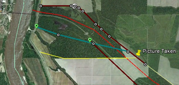
 What you see above is the yellow route, below. The picture above is taken at "Picture Taken".
This property is presently freshly plowed. That fact would add to and enhance what was to come.
{LOL}
It is a power line route though it may serve, or had served, more purposes as it approaches the river.
The teal route, what I presume is the actual "old 10", is shown as "Old Highway 10" on some maps.
The dark red line is present day, or rather the last reincarnation of La.10.
The brighter red line is yet another mystery whose speculative explanation is to follow.
 Below is Stonehenge in its glory at the yellow line bordered field above. Wheat was the crop in 2008.

There would be no further realized opportunities to visit the "rails" going west past Ravenswood, Laio Rd.
{Evidently, during the initial writing I went into a moment of reflectiveness}
I think this is the way it happened.
I became interested in another of the Atchafalaya rail bridges, this time the one at Krotz Springs.
A friend had given me a copy of the Krotz Springs commemorative calendar.
It pictured this damaged bridge (below).
I asked an expert about the bridge and he said that there had only been one bridge at KS.
This was not it.
I had found pictures of the damaged bridge at Melville. They matched the "Krotz Springs" bridge.
KS's calendar had it wrong.
By the way, this shot was taken opposite Melville.

The original Melville bridge (built around 1885) had been damaged in the horrible flooding of 1927.
Below are a few pictures of those times.
This is from the Melville side (west).
Note the skinny supports. That observation will be important down this page.
This shot, of course, required a long pole as I surely would not be on the tracks.
Then one day, as I was climbing down from that location, oops, and a fast moving train appeared.
I had thought the roar I was hearing was farm machinery.
This was a "lucky shot". I'll leave it at that.
It was also the last needed from that location, an easy decision on my part.
Then, I got interested in a little siding off of La.77, a short distance north of Fordoche,
a historical community.
This is the map I had.
The map shows the railroad between the Livonia yard and Melville.
Take care, you'll be mapped out by the time this one is over.
The spot, McKneely Spur, yes, on the map, is east of Red Cross and between the Atchafalaya bridge and Fordoche.
La.10, or what was once La.10, the gravel stretch, is also between
Red Cross (Melville east) and Highway 77 creating a triangle of mystery.
Simply, I wanted to check out the rails between McKneely Spur, on 77,
and the bridge. That length of rail lies within the Morganza Spillway,
the recently (2011) opened relief valve for a badly flooding Mississippi River.
The rails are elevated across the spillway.
I did an article about one of my adventures in search of places where I could visit those rails.
With permission, I took the east levee (last line of defense for Pointe Coupee Parish)
to where the rails crossed the levee into the spillway.
East is right, west and the spillway are left.
Excerpts from that write are below.
I was slowly discovering the modern outer layer of history.
To clarify, the term "Stonehenge", used often in this one, is the local name of the elevated bridge as
it resembles that structure in England (using a healthy serving of imagination).
There was no bridge in either direction at this point along the railroad looking from the levee crossing.
"McKneely" has been spelled differently throughout history. (my history)
The fact is that spanning the Morganza Spillway uses a mix of high elevated berms
and bridges which allow for the flow of water, migration of animals and whatever
I'm not thinking of right now. Hunters? Yes, hunters, also.
This topo map, courtesy of Mark, our high trestle expert and radio man,
shows the berms clearly. I have colored in where the bridges are.
It traverses the original location of Ravenswood, now a hunting camp.
I would find Stonehenge where the road meets the rails and now ends.
It once continued on and eventually met La.81.
I, of course, climbed up. Just kidding, I used my pole.
Many old maps show La. 10 not being where it is today.
The presumed old route shot for the ferry landing at Red Cross.
That is one of the mysteries of the McKneely Triangle.
Fear not, one of many maps is coming up.
This property is presently freshly plowed. That fact would add to and enhance what was to come.
{LOL}
It is a power line route though it may serve, or had served, more purposes as it approaches the river.
The teal route, what I presume is the actual "old 10", is shown as "Old Highway 10" on some maps.
The dark red line is present day, or rather the last reincarnation of La.10.
The brighter red line is yet another mystery whose speculative explanation is to follow.
There would be no further realized opportunities to visit the "rails" going west past Ravenswood, Laio Rd.
{Evidently, during the initial writing I went into a moment of reflectiveness}
I think this is the way it happened.
I became interested in another of the Atchafalaya rail bridges, this time the one at Krotz Springs.
A friend had given me a copy of the Krotz Springs commemorative calendar.
It pictured this damaged bridge (below).
I asked an expert about the bridge and he said that there had only been one bridge at KS.
This was not it.
I had found pictures of the damaged bridge at Melville. They matched the "Krotz Springs" bridge.
KS's calendar had it wrong.
By the way, this shot was taken opposite Melville.
The original Melville bridge (built around 1885) had been damaged in the horrible flooding of 1927.
Below are a few pictures of those times.
This is from the Melville side (west).
Note the skinny supports. That observation will be important down this page.

The one below is taken of a train arriving at Red Cross (east side)

Looking south: Melville is on the west (right). Red Cross is on the east side of the river (left).

Panning west is inundated Melville.

The supports on the new bridge are much more massive.
The new bridge is a lift type as apposed to a swing type in the old version.
I can't make a call as to whether spans of the old bridge were used on the new one
or if the new bridge was not built (on top) of the old one adding the lift in place of the swing
and replacing the supports. That, for me, will take some time. Yet again I'm getting ahead of the story.
I can't make a call as to whether spans of the old bridge were used on the new one
or if the new bridge was not built (on top) of the old one adding the lift in place of the swing
and replacing the supports. That, for me, will take some time. Yet again I'm getting ahead of the story.
Mark had rekindled my interest in McKneely Spur, a short spur off of the main line above Frodoche.
There was more there than the short historic rails to a log loading area.
There was a second track crossing the highway and taking off to the northwest.
I asked Agent 00L about it and he said, "That's a simple one".
"Simple" unless you try to find it.
It was the route the Texas and Pacific Railroad took to the bridge from, approximately, La.77.
Of note, McKneely Spur was then a spur which crossed the highway. That's my assumption.
I believe the switch for McKneely was to the east of La.77.
That just crossed my mind.
Where was I?
Just what I needed, another mystery injected into a swirl of mysteries within the triangle.
After 00L's explanation I lost interest or got involved in chasing Amtrak to simplify my life.
Again, enters Mark to stir the pot.
"Steve, there's something going on at McKneely Spur. There's a lot
construction work and the road has a flagman on it.".
Ok, that was cool. I needed a ride to someplace other than Alligator Point
or the yard or Bayou Sale to see yet another blue and silver flash.
Clippings from that outing are below.
Sure enough there was "activity". I waltzed in with no one around on a Friday afternoon.
Seems like they were building a sidetrack / passing track
probably to relieve congestion at the bridge and the huge Livonia Yard.

How are those glasses working?
That was all on the east side of La.7 and reached far beyond the start of the
of the old T&P route.
I was interested in what was west of 77, the old way to the bridge.
Mark made a preliminary ride and sent a lot of pictures and explanations of what he'd seen.
I was like a kid waiting for Christmas morning.
Mark's presents were around the tree and what wasn't opened, needed to be.
.jpg)
Here's an explanation of McKneely Spur.
The words you can't read (south of the tracks) are "Mainline" and "McKneely Spur".
That's your anchor shot for this ride.

Then, from what he had discovered, I set about looking at maps, a process that seems endless.
Mark and I use the same mapping program. It is easy for him to send his "tracks" to me and mine to him.
The gray dotted line is where he rode.
The present day tracks can be seen, as can the "La-10" route, not the present La.10 which he was on.
Of note, he notes seeing an "Elevated Fill".

Mark and I use the same mapping program. It is easy for him to send his "tracks" to me and mine to him.
The gray dotted line is where he rode.
The present day tracks can be seen, as can the "La-10" route, not the present La.10 which he was on.
Of note, he notes seeing an "Elevated Fill".
I had seen, possibly the same "elevated fill", on a previous ride, but had blown it off as a lost bit of history
or possibly a pile of dirt with no real historical value.
That was during the winter of '08 and I was probably cold. You do see it (below)?
Oh, the red line above is where I guessed the old rails having passed.
Mark agreed that I was pretty much "dead on".
Using the bits and pieces of "high spot" recognition on his great donated topographic map, it fit.

Overlaying his route ( hard to see gray line) you can see his mauve colored anchor route. He drew
that in prior to visiting in order to keep himself oriented, something I fail at.
"Row 1" and "Row 2" are locations along the old T&P where he took pictures.
Also referenced is his notation of "Elevated Fill", which is exactly where I found it. That later.

Then we got into a discussion on when and what was elevated and where the old bridge was,
you know, stuff people with great minds discuss daily.
Then I found this, a picture of the train going to or at Red Cross.
The rails had to have been elevated and of course they were, just as the new ones are, but
not as high as the Morganza Spillway was not even a glimmer in the designers eye.
The levee on the river was there, but not the outer Morganza levee near La. 77.
Evidently, the railroad knew this area was subject to flooding without the river's influence.
Heck, all of south Louisiana is subject to flooding. The berm was not rocket science.
Then I found this. The date when the routes across the spillway were changed was another mystery.
"Proposed" is the key word in that title.
The date, "1946" was quite helpful.
The fact that the book is not digitized, was not helpful.

I kept plugging away and found this excerpt from the History of Avoyelles Parish.


Above, "practically completed" may refer to obtaining of the "flowage rights" and levee building, not the
actual full completion of the control structure, etc.
Wiki concurs, "Construction of the levees that make up part of the Morganza Spillway began in the late 1930s. The Morganza Control Structure portion of the project was completed in 1954 and subsequently became incorporated into the Mississippi River Commission's 1956 project design flood, which added the Old River Control Structure (ORCS) in 1963 to the protections used to prevent Mississippi River flood".
That was enough to conclude approximately, as to when the old T&P route was abandoned.
Coming into play is the appearance of Stonehenge.
The trestle appears to be a very "modern" design..
I know La.1, the surface route across the intake of the spillway
was abandoned and replaced by the route atop the control structure in the 50's,
probably the late 50's. I believe the old T&P RR route continued into the late
'40's or early 50's. The "Investigation and Review of Design ....", shown above, bears that out.
But how about the bridge. Had it's location been moved or replacement done on location?
Below is the "modern" bridge.
.jpg)
Below is the one at Courtableau, west of Krotz Springs near US 190.
I was going to correlate, but no cigar, they are different. 
Mark and I have come to the conclusion, though I thought otherwise from being there,
that the reality looked like this (below). Ignore the little red line bending north, my hand twitched.
In considering the location of the old bridge, Melville had to be included.
Mark figured the old bridge to be no more than 50 feet from the "new" one if a different bridge.
I had estimated 175 feet putting it on the north side of a borrow pit. That picture below this one.

It sure looks like a bridge approach, but, it is too low. Who knows what has transpired over time.
Officially, I'm going with Mark's 50 foot from the present bridge guess since the overpass is marked as
being built in 1928. It's there if you look..
There's another mystery.
.jpg)
Repeat, the new replacement bridge was built in 1928.
The new right of way was done after 1946.
Conclusion: the old rails had to hook up with the new bridge some way.
Or, the new bridge was in the same place as the old bridge.
And, wherever the new bridge landed in Melville, there would have to be adjustments.
Just what I needed, another mystery.
That bare place above the "new" bridge in Melville looks like
a possibility. There seems to be a hump coming west off the levee, also.

Back in 2008 I saw this. This was Red Cross. I have no idea
how developed it was. But, a slab of concrete is a serious investment
for an early location. I just thought about the slab at Torras Junction but
quickly snapped back to this one.
for an early location. I just thought about the slab at Torras Junction but
quickly snapped back to this one.

I deleted a bunch of maps because they were redundant. There's enough redundancy waiting.
This map has the mystery road as "Old la-10" which is my belief, just not
where I thought it was, on the edge of the woods at he plowed field and next to the embankment .
It would make sense for the road to go to the ferry which the road (La.10) served.
Otherwise the ferry would be above the railroad. That would not
work too well because there would be a danger of the ferry being driven
into the rail bridges supports if there was a power failure and besides, La.
10 is on the south side of the tracks and bridge in Melville. Pardon the private theorizing.

Mark sent this. He never identified where exactly it was.
Now I'll get hate mail from him but that's OK, I'll
put it in the stack with the rest of the back letters.
I do believe it is where he did say it was in a round about way,
50 feet from the present ROW and bridge approach.
Actually, that was pretty straight forward.

Upper Laio Road (on some maps) is actually La.10 (rip). Laio Road may have originally started from
the levee, just a thought since coming from the east would have required crossing a swamp. But,
during the Civil War, the Rebs did cross the Atchafalaya and attack where La.10 now meets La.77.
Yet, another mystery.
La.10 is, I'm blue in the face with maps of La.10.
the levee, just a thought since coming from the east would have required crossing a swamp. But,
during the Civil War, the Rebs did cross the Atchafalaya and attack where La.10 now meets La.77.
Yet, another mystery.
La.10 is, I'm blue in the face with maps of La.10.

But, this one may have a little unique value. Above you see a road hanging off what they call "Laio Road". It is the present road marked as "Laio Road", the road to old Ravenswood. Zooming in on another map,
in the vicinity of Johnson Bayou there was what appeared to
be an old logging tram. The original route would have been built in the 1880's. That logging tram would
have crossed it. Reminder: the old T&P RR route lay between the present ROW and Highway 10.
Old logging tram.
in the vicinity of Johnson Bayou there was what appeared to
be an old logging tram. The original route would have been built in the 1880's. That logging tram would
have crossed it. Reminder: the old T&P RR route lay between the present ROW and Highway 10.
Old logging tram.

Let's get back to Ravenswood and the present Laio road. Laio Rd takes you through old
Ravenswood, now the hunting camp and out to the Stonehenge.
The road turns as to address the row straight on, crossing the "tracks" squarely.
Ravenswood, now the hunting camp and out to the Stonehenge.
The road turns as to address the row straight on, crossing the "tracks" squarely.

This is the research portion's grand finale with the maps.
Redundant, yes, but you'll thank me when you take the test.
Heavy red is the last reincarnation of La.10.
Bright red is my interpretation of the Texas and Pacific RR's route to the old Atchafalaya Bridge.
Right below it in gray is the present rail route.
Below it, in teal is the route of "old la.10".
Yellow isthe route I thought was "old la 10" and is a mystery.

Now, armed with only a small portion of the info above, I headed to the McKneely Triangle.
But, not directly as I had a cake to drop off at Marks since he says his dad has a hollow
leg that rattles when empty.
The historic train / rail chasing I knew could wait. For the most part nothing would change much.
Catching real time rail activity is another deal.
I rode into Opelousas with perfect timing.
One of the AKDN RR engines was working Louana Oil, our favorite.
.jpg)
I do action sequences that don't need explaining. Here we go.
People look only at the pictures anyway. Man are they confused up to now.
People look only at the pictures anyway. Man are they confused up to now.
.jpg)
Alright. She was backing up, taking her cars full of oil, around the south side of Louana (the Louana Loop)
and then on to Statesman St. Yard where I waited but she never showed up so I delivered Mark's cake.
By the way. Louana Oil sits where there was a complicated rail interchange. Texas & Pacific, once
the OGNE, Southern Pacific as well as Missouri Pacific Railroads met there
In Mark's father's words, "It must have been a busy place".
BTW, Mr. D. found the the Opelousas Gulf and Northwestern route through Opelousas, a
severe problem for Mark and I, well two.
The fact that he found it and we couldn't was troubling. And, the fact that it was a
challenge, at least to two "young" punks.
Back to the ride.
.jpg)
AKDN 4106 is a pretty little engine, even backing up.
.jpg)
She is also very patriotic though there has been "clearance" problems..
.jpg)
The Statesman St. Yard (old T&P to Ville Platte)
.jpg)
I made the required stop at the shop.
.jpg)
There are those amongst us that enjoy rail junkyards.
"Trying to see if something has changed" is the game here.
"Trying to see if something has changed" is the game here.
.jpg)
After coming back, I caught her in the yard pulling forward with more cars attached.
I blew it. After a few pictures from my new found vantage point, I left
When I got back she was gone with all the cars.
Going east I checked along US 190 and she was not there.
If she had gone north, it would have been a very unique outing. No, I believe she went to Livonia.
I blew it. After a few pictures from my new found vantage point, I left
When I got back she was gone with all the cars.
Going east I checked along US 190 and she was not there.
If she had gone north, it would have been a very unique outing. No, I believe she went to Livonia.
.jpg)
.jpg)
.jpg)
.jpg)
.jpg)
.jpg)
.jpg)
She backed up and I thought she was done. Not so and, as I said, I blew it. McKneely could have waited
Again, my thoughts are that she hauled it for Livonia. A shot of her on the Krotz Springs Bridge would have
been a knockout.
Again, my thoughts are that she hauled it for Livonia. A shot of her on the Krotz Springs Bridge would have
been a knockout.
.jpg)
And there she goes back into the yard.
.jpg)
.jpg)
While looking for "Greenie" at Krotz Springs, I found a Big Un.
I failed to check out its cars to see if they matched Greenie's, at least in part.
I failed to check out its cars to see if they matched Greenie's, at least in part.
.jpg)
This often seen scene was once again replicated. The train is climbing onto the KS bridge.
.jpg)
.jpg)
.jpg)
I crossed the bridge and headed up La.735. I use that number since I don't remember the real one.
It's decommissioned anyway being little more than a class A dirt road.
The DR (my bike) ate it up cruising the chug holes at 50. I was getting that old Claiborne Trails rush.
You'd have to be a dirt bike rider to understand that.
It's decommissioned anyway being little more than a class A dirt road.
The DR (my bike) ate it up cruising the chug holes at 50. I was getting that old Claiborne Trails rush.
You'd have to be a dirt bike rider to understand that.
.jpg)
The Atchafalaya levee is to the left (west). I'll
presume this is a borrow pit or a cut off bayou.
Whatever, it is gorgeous.
presume this is a borrow pit or a cut off bayou.
Whatever, it is gorgeous.
.jpg)
Swim at your own risk.
.jpg)
I liked this place, also.
.jpg)
And, here I was at one of my favorite spots, the east side Melville Ferry landing (rip) The ferry is "history".
.jpg)
And there's old Betsy, the 1928 version of the Atchafalaya crossing.
.jpg)
My first intent upon arriving was to find where "old la.10" met the levee road.
I used the "power line" theory since there were power lines at the incorrect location at the edge of the woods, the yellow route on the map.
I used the "power line" theory since there were power lines at the incorrect location at the edge of the woods, the yellow route on the map.
.jpg)
In reality, I think I did find "old la 10" as it exited the woods just before the ferry ramp.
The present rail overpass is in the close distance.
The present rail overpass is in the close distance.
.jpg)
Everyone likes to find cement blocks. I found these close to present day La.10 (rip)
Remember, the old Texas & Pacific ROW was between the present rails and the new version of La.10,
aka Laio Road, at least in part. Assuming the old T&P was very close to the present rails, especially
since I can say without impunity, that the old rails were attached to the new bridge, these hunks of cement
possibly were not associated with the railroad. but, there's always a chance.
.jpg)
I saw these two "driveways" exiting the levee road. Their distance from the bridge probably means that they
were just that, driveways.
were just that, driveways.
.jpg)
About the time I was getting board, here came a train out of Livonia to spice things up.
.jpg)
.jpg)
.jpg)
Under cover of the train, I climbed the levee.
Immediately a smiling man in a white pickup approached me. He didn't even roll down his windows.
Feeling that I was being ignored, I knocked on his door. He rolled down the window, hesitantly,
and I proceeded to read off the entire nature of my mission, much like this ride report.
He smiled as if confronted by a mad man, a helmeted mad man, which was bewildering to me.
I had just given him something to tell his grandkids. (Don't go on the levee when you see a madman)
.jpg)
I tried to connect power lines to presumed rail ROW's.
It was 94 degrees, the humidity was in the triple digits,
and I was standing on a levee with a helmet on trying to think.
I had no one with whom to confer so I tried talking to myself until
I saw the man in the white pickup pointing at me.
Possibly I should have whispered.
It was 94 degrees, the humidity was in the triple digits,
and I was standing on a levee with a helmet on trying to think.
I had no one with whom to confer so I tried talking to myself until
I saw the man in the white pickup pointing at me.
Possibly I should have whispered.
.jpg)
Here is a rare view of the north side of the east side Atchafalaya bridge approach. This shot may be
invaluable in theorizing whether parts of the old bridge were used in the replacement version.
Mark has been repeating over and over that the bridge was rebuilt, not replaced, and I think
I'm finally believing it. Is that "indoctrination"? Our country's liberal leaning are a testament to the
power of persuasion from a community organizing man.
.jpg)
I thought I'd found the Holly Grail of bridge approach earth work.
I stood close to the present ROW and shot north toward where the man in the white truck was.
Look along the left side of the levee. You will see a protruding ramp. Using Bing maps, it is
the raised area along the north side of a pond.
I stood close to the present ROW and shot north toward where the man in the white truck was.
Look along the left side of the levee. You will see a protruding ramp. Using Bing maps, it is
the raised area along the north side of a pond.
.jpg)
Just for the heck of it I shot down the levee to where I'd parked my bike. Inadvertently, I may have nailed
the T&P. Now, I hate it when this happens. If the new bridge was used by the old T&P, then it would have
too gain some altitude to match the bridge. There is a high berm out there if my theory is correct. But,
Im not going out there. You can look for snakes on the ground and one will drop onto your neck from a
tree. This is the Atchafalaya Basin, no mater how tame it looks, vindictive residents of the once great
swamp linger.
.jpg)
Here's what I thought was the Grail. I now think, "maybe not, but still, maybe so".
Maybe it was the route to a dock that was used in the bridge building?
Call me "speculative".
Maybe it was the route to a dock that was used in the bridge building?
Call me "speculative".
Looking back across the levee from that spot, the hole in the woods made me suspicious.
See the two "driveways".
See the two "driveways".
.jpg)
See the hole?
.jpg)
Looking at the new ROW from the "rampart" location, 175 feet, or more, away.
.jpg)
Was it the helmet? Or, was it just desire? I was getting, and may be now, delirious.
.jpg)
Somehow, I thought taking a picture of that tree from road levee would help. Scroll up. It is the tree by the rampart, proving nothing.
.jpg)
Looking into the woods, I shot this at that point.
I only saw it in the picture. It's a post. Possibly meaningless, but maybe not.
I only saw it in the picture. It's a post. Possibly meaningless, but maybe not.
.jpg)
The post almost lined up with the tree, but not really.
.jpg)
Around that area I saw this. I wish I'd had a magnet.
.jpg)
Had enough of that? You should have been there.
Next. Mark had found the trestle over Johnson Bayou.
I had to see it for myself. I don't know how he nailed it, but he did.
This is a fair ways from New 10.
Next. Mark had found the trestle over Johnson Bayou.
I had to see it for myself. I don't know how he nailed it, but he did.
This is a fair ways from New 10.
.jpg)
It is in that bend in the bayou. Looking at the topo map, that place is clearly seen.
And, don't forget about the logging tram (speculative) that ran along the bayou (highest altitude)
on the left (east) side going south (straight ahead).
And, don't forget about the logging tram (speculative) that ran along the bayou (highest altitude)
on the left (east) side going south (straight ahead).
.jpg)
I was going east on La.10 away from the levee road and all that previous speculation.
I was now in hard evidence country. The embankment lay about 125 feet to
the north of La.10, upper Laio Rd.
I was now in hard evidence country. The embankment lay about 125 feet to
the north of La.10, upper Laio Rd.
.jpg)
Don't believe your eyes? Neither did I, but Mark said, "Elevated Fill" and he wasn't wrong.
.jpg)
I crept up, always looking overhead and at my feet.
.jpg)
I really really wanted to get on top but something told me to leave this one alone.
.jpg)
Next I came to the field where I had wrongly thought that "old la.10 had veered off to the ferry landing.
This is where the mystery yellow line starts. I wondered how I was going to get through that fence to find where the fill had been cut off by the farmer. There was no fence to my left. I almost went between the wires.
This is where the mystery yellow line starts. I wondered how I was going to get through that fence to find where the fill had been cut off by the farmer. There was no fence to my left. I almost went between the wires.
.jpg)
At my foot was a tie. Dont' get excited, they are commonly hauled in as fence building parts.
If the T&P's old route had been in use up to at least 1947 and probably into the 50's, which I say it was,
then the likelihood of the tie being native is high.
If the T&P's old route had been in use up to at least 1947 and probably into the 50's, which I say it was,
then the likelihood of the tie being native is high.
.jpg)
Then I saw another block of cement with threaded studs protruding on the small end.
The bridge used a single track. There was a need for side tracks to accommodate waiting trains.
Possibly one was here and the cement block had something to do with it. I won't go into specifics.
The bridge used a single track. There was a need for side tracks to accommodate waiting trains.
Possibly one was here and the cement block had something to do with it. I won't go into specifics.
.jpg)
.jpg)
I panned around for a shot of Stonehenge. I should have prowled around for more artifacts. Notice the time.
I was hot and tired and alone on private snake filled property. I needed to be efficient and careful.
This is looking back at the road. I use these pictures as distance references thought that makes no sense.
Taking them does make sense because you can see missed stuff like
the remnants of the fill seen as a slight hump on the ground. Sure you can!!
.jpg)
There it is in there. Sure you can see it!!
.jpg)
You can almost touch it. That's right, you can. I'm wasn't sticking my hand in there.
.jpg) Another artifact?
Another artifact? .jpg)
This is looking down the yellow line. (on those maps way way above).
I should have lightened this one up. Stonehenge is to the left.
Possibly the dark shot reflects the strangeness of the McKneely Triangle and its unknown or a
cloud passing between the sun and I?
.jpg)
Ah, now the good stuff. I went down Laio Road and caught the hump where the T&P crossed.
.jpg)
The hunters, like in the Basin on the old SP/ BR route, use the ROW as a trail.
.jpg)
Again:
.jpg)
Off to the left you can see it. Notice, being that this was further east and "uphill", the berm is lower.
It was not preparing to cross a levee as the new Morganza guide levee was NOT THERE YET.
Sorry for yelling.
It was not preparing to cross a levee as the new Morganza guide levee was NOT THERE YET.
Sorry for yelling.
.jpg)
At McKneely Spur I stopped. There were trucks moving about and I hesitated until I talked to a Mexican
truck driver who spoke no English except for "No Problem". Assured, I proceeded on.
truck driver who spoke no English except for "No Problem". Assured, I proceeded on.
.jpg)
There he sat, no problem.
.jpg)
The last bit of the route was to explore from La.77 toward the bridge as far as I could which meant going
against the dirt trucks coming from their supply source to where the railroad was building their passing track on the east side of La.77 toward Fordoche. The red line is the historic T&P's.

Away I went.
against the dirt trucks coming from their supply source to where the railroad was building their passing track on the east side of La.77 toward Fordoche. The red line is the historic T&P's.
Away I went.
This guy (below) ignored me.
I banged on his window and basically told him everything I've told you, plus I showed him my pictures.
He rolled up his window on me, almost smashing my camera.
The excavators had eaten the embankment. But, at least it had gone into building a new one.
This picture is taken from the "tracks", now the road.
I failed to take the shot I should have, the one from the road / ROW which would have nailed where the
existing berm continued. I don't think it's the obvious pile you see, but maybe.
.jpg)
Looking back east.
.jpg)
I left, watching the caterpillar smooth the field got boring and the fellas wouldn't talk to me.
Between Lottie and Livonia, another sidetrack is being built.
US 190 is on the other side of the tracks.
Back in 1954, my family and I were coming down US 190 in an old Dodge. The rear end went out
and the folks at the Lottie Garage, the building in the distance, fixed our car. I've often
wanted to drop in there and see if it is a "family business". I was 7.
.jpg)
This one is for Al.
He doesn't like the railroad stuff much but does like storage bins having invented a system a while back.
He doesn't like the railroad stuff much but does like storage bins having invented a system a while back.
.jpg)
The old Smith Farm building is falling down.
.jpg)
And so am I after writing this long long ride report on researching and visiting the McKneely Triangle.
Don't go there at night, watch the trees and your feet.
Over and Out.
Don't go there at night, watch the trees and your feet.
Over and Out.
.jpg)