{ Update note: I recently rode back over to Raceland and resumed following the tracks east. I knew this was going to be a long one, and maybe the last one in this area for a while, so I was going to be as thorough as possible with the time I had left after the long trip over. Coming up La.20, I stopped for a break and while out by the tracks I saw a light approaching. I laughed as I assumed the place to be private. Private places are scarce on the road these days. Anyway, here comes this light. Mercy me, it was the the Sunset Limited. I stumbled down the embankment and ran to Mz Guzzi, vaulted upon her back and spurred her hard. Evidently, the train had been given the reigns, also. I couldn't catch her without asking for a ticket. I am the guy that will get one as I'm a ticket magnet, so proven in my younger years. At Schriever, she stopped at the depot. Passengers were disembarking. Instead of stopping and zooming in the camera, I attempted to get closer to catch an engine shot back to the old depot. That would have been a classic. As the last passenger's foot hit the ground, she pulled out of the station. No shot. Ya can't always get what ya want, but............and we all know the rest of that line. Nevertheless, I would get what I needed all down the line. A few pictures of the rest of that ride will follow as it will be for the late comers. The premium members have already read that whole ride in full. You've been offered an opportunity to sign up for these emailed ride reports and I received zero applications which left me feeling unwanted, unloved and vindictive. So, you get the short version. Touchet, mon amis.}
{The trainless depot shot on the ride before the last ride.}
.jpg)
.jpg)
{Its location in relation to Thibodaux Junction.

{Schriever was the axle for all the short branches that
emanated from it. Houma was one.}

{Lockport was another.}

{Napoleonville was another.
I'll have to find that one in my stash.}
{And, some old business from the last page,
Thibodaux was not named for Boudreaux's friend.}

{He was the Captain of the LaFourche Volunteers who
fought alongside General Jackson and Jean Lafitte at the
Battle of New Orleans. The dude was a dude.}
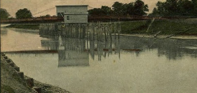
{And, I found this picture of an old bridge spanning the bayou
at Thibodaux.}

{I don't think it would have supported rail traffic. But, the T&P
had to jump the bayou some way, and my trusty Garvin Topo
said it did.}
{Ah, and a teaser to go back and reread a prior page of this ride.}

{I'll tell you when that the last ride's pictures have
been dissected from the group and placed in the appropriate
places along the line coming out of the West Bank.
They are not there yet!!}
{Now, back to our 1930's tour director:}
An alluvial ridge extends southward along Bayou Terrebonne through Schriever, and another, extending along Black Bayou, is followed by a branch railroad to Houma.
{The author is not clear here. There was no SP railroad down Bayou Black which is west of Schriever at Gibson. The Houma branch dove due south from Schriever . It went along Quishi Bayou and Little Black Bayou into town. Back to his spiel.}
At this old town {Houma} there is a large sugar refinery and an extensive business in oysters and other gulf products. Much sugarcane is raised in this part of Louisiana, and formerly there were many small sugar refineries, some of which are still visible. {the smoke stacks were left} Potatoes have lately become an important product, and considerable corn is raised. Between the alluvial ridges the land is low and swampy, but in places it can be drained by pumping; one notable reclaimed area of this kind southwest of Raceland is yielding large crops of corn. In the swamps cypress, tupelo gum, and other trees flourish. Lumbering has long been an active industry, but many years of vigorous lumbering has greatly reduced the amount of timber available.
{The rape of the red cypress forest is evident. Unlike the reforestation of pine country, when it was gone, it was gone, thanks to mills like Bowie. Replacing 400 year cypress is like replacing the Sequoias.}
There was formerly a sawmill at Chacaholua, and at Donner a large mill is in operation on logs brought by rail and in "booms" rafted through the great system of waterways traversing the lowlands to the north.
Donner.
Elevation 11 feet.
Population 900.*
New Orleans 65 miles.
Donner is in the large lowland area that was covered by the great flood of the Mississippi River in 1927, when in the lower places the water was from 6 to 10 feet deep for several months. The flooded district extended far to the north and northwest over the lake region and the country traversed by the Grand and Atchafalaya Rivers. The bayou ridges described above (p. 14) were not covered, but the water extended far up their slopes. During the flood thousands of residents on the lower lands were driven out by the water, and there was considerable loss of crops and effects. The railroad embankment near Donner was slightly submerged, and parts of it had to be protected from the flood waters. In this region the roads are surfaced with oyster shells, which make an admirable road metal for light traffic. Shells are also burned as a source of lime.
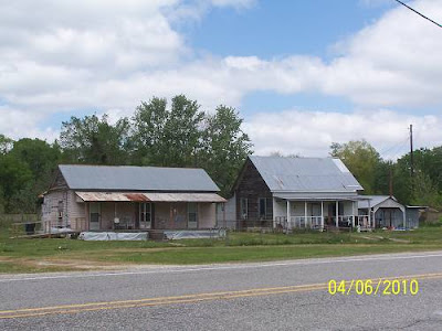
{This, I believe, is a great old "tourist court" at Donner.
Donner and Chacaholua blend together. I'm assuming
there was a depot here and that the court serviced those
passengers. It may have been a resort for those interested
in hunting and fishing. The larger building is a full service
gas station of old. It is now a tire repair shop, opened only
on certain days. This area was remote.
.jpg)
These places are on the rail side of the highway. Whether
they predate the Great Flood, I can't say.
.jpg)
CLICK HERE to go to PAGE 5