On this page I've chosen to leave most of the ancient history behind and jump right into the trip as howls from the readership have forced me into a corner. Actually, only one or two of the people who I consider associates cared to comment on my last effort and only they are getting this page with my good graces. So, if you are not reading this masterpiece, you know why. If you are reading it and did not comment on the last page, I consider you salvageable but not of prime quality.
I found this report on line. I haven't read it yet, so I'll be taking notes and dissecting it as we go along. It is a USGS (US Geological Survey) report. What I find interesting is the railroad aspect of it. The geological stuff will bore you to tears. It was written in the 1930's which makes it appealing to me. Knowing that there is something older than myself is comforting. So, what I'm going to do is cut it down to what I find palatable. I am not picky so proceed at your own risk. I'll include the link to the full volumn so you can read the entire thing if you want. That will be when we get to Lafayette, a long, long ways away. I will augment as I can with pithy comments and a trillion pictures. After all, what's a trillion here and a trillion there, right Stinky (BO)?
Below are the writer's words. What I add will be in brackets. It's easier than hitting the quote button for every paragraph. {That I found debatable. I know where the quote keys are.}
Of note, the write starts in Algiers, West Bank, Greater New Orleans. There was no Huey P. Long dual purpose bridge there at the time of this writing. In 1935 there would be. Though not a part of this trip, here she is, a true wonder of t he world and it was somewhat duplicated in Baton Rouge a few years later.
_(320_x_240).jpg)
Below the author speaks of Jefferson. It is the location
of Oxchner Hospital and where the "SP745" is kept.
Now that's another story. Click below to read easier.


Here he goes. Imagine a 1930's railroad documentary film.
HISTORY OF THE RAILROAD {The Southern Pacific's this time. Remember his viewpoint
is the mid '30's.}
The railroad from New Orleans to Los Angeles is part of an extensive system with many individual members, of which the Southern Pacific Co. owns all or very nearly all of the capital stock. The line from Algiers, La. to Lafayette, La., now known as Morgan's Louisiana & Texas Railroad & Steamship Co. was incorporated in 1852 as the New Orleans, Opelousas & Great Western Railroad Co. It reached Morgan City (Brashear ) in 1857 and Lafayette in 1880. It was operated by the United States during the Civil War and owned by Charles Morgan from 1870 to
1878.
{This speaks of west of Lafayette, more than I am willing to deal with at this time, thought I've ridden it all.}
The Louisiana & Western Railroad Co. was built from Lafayette to the Sabine River in 1881, and the Texas & New Orleans Railroad Co. was constructed from Orange to Sabine River (Echo) in 1878-81. The latter was operated as part of the Louisiana Western Railroad until 1900. The Sabine & Galveston Bay Railroad & Lumber Co., later the Texas & New Orleans Railroad Co., built a line from Houston to Liberty in 1856-60 and from Orange to Liberty in 1859-60. It was dismantled by the Confederates in 1865 and restored in 1870.
{The write goes on to explain each stretch west. What follows are general statements and descriptions.}
The Southern Pacific Railroad from New Orleans to Los Angeles, a distance of about 2,000 miles, passes through a region exhibiting a great variety of geographic and industrial conditions. The climate, especially the amount of precipitation, is the most influential factor in causing this variety.
The low Coastal Plain of southern Louisiana and eastern Texas, with ample rainfall and thick rich soils, is a province distinct in configuration, human occupations, and products. There are extensive swamps, prairies, and wooded areas, but a large part of the land is under cultivation, with sugarcane, cotton, and rice as the principal crops. The streams are wide and slow, the winter climate is mild, and the summer heat is tempered by breezes from the Gulf of Mexico. Flourishing towns occur at short intervals, and some of them are growing rapidly. The entire region is underlain by a great thickness of sand and clay of alluvial origin.
Figures given on mileposts in Louisiana indicate miles from Algiers, a Southern Pacific freight terminal on the south bank of the Mississippi River opposite New Orleans; they are about 1-1/2 miles less than the distance from the Union Station, New Orleans.
{I'm cutting the flowery description here.}
{The trip begins. Note the mention of the ferry and the proposed Huey P.}
{This ferry was regarded as a "temporary expedient".}
Leaving the Union Station, New Orleans, the Southern Pacific train uses the tracks of the Illinois Central Railroad as far as Harahan Junction, a switch station on the north side of the Mississippi River. Thence the line crosses the river flat in a southerly direction and in 2 miles reaches the levee, over which it passes on an incline. Here on the bank of the Mississippi the entire train, divided in sections, is placed on a huge steel barge (The Mastodon) to be ferried across the swift current to Avondale, on the southwest bank, a distance of nearly a mile. The floats are adjustable for different stages of the river, for there is considerable variation in the water level consequent on floods and droughts.
{You can click these photo/paragraphs to see them better.}


This is the Mastodon.
.jpg)
This was the SP track and yard layout on Algiers Point.
I believe the article said it was built in the late 1800's and
torn town in the 1950's. I see large buildings where the
green arrows point. And, I see some I missed.

And the guys at the roundhouse.


CLICK HERE for the Algiers site.
Things were not always good.


Avondale.
Elevation 8 feet.
New Orleans 13 miles.
{Reminder: these are distances from Algiers}
At Avondale, not far south of the ferry, the train reaches the Southern Pacific tracks coming from Algiers, the terminal on the south side of the river opposite New Orleans, used only for freight. The land is low behind the levee, and most of it is too swampy for economical cultivation. In this area will be noted many cypress trees, water hyacinths, and other plants typical of the swamps and lowlands of the South. In wet places there are scattered palmettos with their clusters of fan-shaped leaves. Most of the larger trees are festooned with the parasitic Spanish moss.
{Spanish Moss is not parasitic}
Des Allemands.
Elevation 9 feet.
Population 400.
New Orleans 33 miles.
To the small local settlement at Boutte the railroad proceeds along the natural embankment of the river and then follows a low ridge through the woodlands to Des Allemands, where Bayou des Allemands is crossed. This name is derived from a small settlement of Germans founded in colonial days, but the population now consists mostly of people of French origin living in primitive dwellings along the water's edge. For many years there was a sawmill here which cut cypress lumber from the adjoining swamp lands; now the supply of this material is practically exhausted, and the main resources are fishing, crabbing, and the trapping of muskrat and other fur-bearing animals.

{I'm inserting a borrowed picture here as filler until I can take my own, next trip.
Exploring Des Allemands and Boutee, along with Paradis, will be something new.}

{I'm also inserting a little Civil War here to keep Rosco Smith happy.}

In midsummer the water bodies in this region are spangled with a beautiful growth of the purple flowers of the water hyacinth.
{Some may not appreciate the plant as you do, sir.}
Bayou des Allemands empties into Barataria Bay, an inlet of the Gulf of Mexico, which was at one time the headquarters of the pirate Jean Lafette.
{Jean would make you walk the plank for spelling his name incorrectly. His only excuse would be to claim he was a blogger or e-mailer.}
Formerly some of the district about Des Allemands was reclaimed for agriculture by ditching and pumping. Now the first signs of extensive cultivation begin near Raceland Junction, where there are fields of cane supplying the large sugar refinery at Raceland, a short distance south. This refinery, which presses about 150,000 tons of cane a season, draws part of its supply from more distant sources, some of it brought down the near-by Bayou Lafourche in barges. An interesting industrial development in the sugar industry in Louisiana is the utilization of the cane residue (bagasse) after the sugar-bearing juice has been pressed out. This material compressed into bales is shipped from many refineries to a large factory at Gretna, across the river from New Orleans, where it is pressed into sheets of building board known as celotex. In some of the cane fields at Raceland experiments are in progress to ascertain the results of using Chilean nitrates as fertilizer. Bowie siding is in the midst of cane fields, and there is a sugar refinery not far south of it.

Between La.1 and La.308 is Bayou LaFourche.
{The walls of our home in Houma were made of celotex
Since he mentions Bowie and Raceland, lets look around.
Bowie was my reason for coming here. It was a red cypress lumber
mill town. It was out at the end of that road. The land tilts here away
from Bayou Lafourche and toward Des Alemans.}
.jpg)

{Panning to the south, the sugar mill comes into view.}
.jpg)
{It is a big one.}
.jpg)
{Raceland Sugar, 1892. I don't know if Dixie Crystals are
still marketed.}
.jpg)
{This the "big house" on the property.}

{Next, I followed the spur into Raceland. If you want to visit
the location of the depot, just ask where the post office is.}
.jpg)
{Places where depots were seem to leave a scar. Some
not only physically.They were the center of many communities.}
.jpg)
{Beauty is in the eye of the beholder.}
.jpg)
{The only contemporary building was this one. A passerby
starred as I took its picture? I always yell, "Look there"!}
.jpg)
{I went back out to the sugar mill to check out what
rails went where.}

{These tanker cars, below, are sitting in the bend south near the depot.
Notice "Bowie" and the siding mentioned. I should have worked
harder at getting back there, but it looked private? The mill is probably
closer to town, also, inside that bend between "Depot and "3199".
I've walked around on the grounds of Valentine Mill, at the end of the
spur which goes down the east bank of the bayou and had no idea
of the weight of the moment. Next time back I won't miss as much.}
{Here's Valentine Sugar Mill (rip). (map above)}

{Here are the cars in the Valentine spur curve going south. The
track going straight, west, would go to the Raceland depot, rip.
Understanding this is terribly important to me. Do I have
a dislodged since of value?}
.jpg)
{Then he goes into a rant about Jean Lafitte but doesn't mention his name at first. Raceland Junction is where my last trip ended. This write will feature more of my pictures from this point on. I include this spiel because there is a section of the Jean Lafitte Cultural Center at Thibodaux. I was too worn out and short on time to go in. That happens way too often. Ok, here he goes.}
This notorious person, {LaFitte} about whom center hundreds of colorful legends of this region, ran a blacksmith shop in New Orleans in the early days of the nineteenth century (at 810 Chartres Street, just off Canal Street). At this time privateersmen in the Caribbean Sea were preying upon the vessels of countries that were hostile to the countries that hired them, and Lafitte became the agent through whom they disposed of the captured cargoes. In time he became the leader of a fleet of licensed privateersmen and established a fortified post on Barataria Bay. He trafficked extensively in slaves, at one time selling 450 negroes at public auction. The proceeds of these sales and his piratical booty buried for safe-keeping are still the object of treasure hunts in the bayou country. For his loyalty to the American forces in the War of 1812, his earlier outlawry was overlooked. He resumed his piracy in 1817 and moved his headquarters from Barataria Bay to Galveston Bay, where his fortifications continued until he was driven out in 1821. Apparently he was finally lost at sea.
{Now he's back to his present.
The abrupt change in agricultural conditions at Raceland is due to the presence of a ridge of alluvium built up by sediments spread by the overflow of Bayou Lafourche. Alluvial uplands of this character are of great economic importance in many parts of the great valley of the Mississippi, for although not wide they have rich soils and are sufficiently high to afford good drainage, roadways, and places for settlement. On them are the principal farm lands in this part of Louisiana. The mound of Bayou Lafourche extends from the Mississippi River at Donaldsonville nearly to the Gulf of Mexico, a length of more than 100 miles. Its height for most of the distance is only about 15 feet, and its width is from 3 to 4 miles.
Bayou Lafourche is the narrow stream crossed by the railroad just beyond Lafourche station.
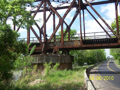
{A tidbit of historical info gleamed from above. Lafourche Station was on the east bank of the bayou. Want to see the bridge? I have pictures, senior. I had come down La.1 from Thibodaux on the west bank. I saw the over pass. I stopped at a gorgeous old house that was a bit away from the tracks as it offered the only safe parking. I could not get a good shot from the shore as it was too thick with brush, so I did what I do and climbed the fill. }
.jpg)
The premium members got the whole ride and what I found
going over to the east bank. You just get the La.308 perspective
of the bridge.
.jpg)
.jpg)
This was not the bridge in the Civil war, but the location.
.jpg)
Originally this bayou was an outlet for part of the flow of the Mississippi River and was extensively utilized by freight boats, but to avoid the floods that occasionally came down the bayou, the connection at Donaldsonville was dammed off in 1903, and the navigability of Bayou Lafourche was greatly reduced. However, it is still used for traffic into the Mississippi River, with which it is connected by locks, and part of its lower course will be followed by the Intracoastal Waterway now projected across the lowlands, some distance south of the Southern Pacific lines.
{Here's a look at what the bridge crossed.}
.jpg)
{Here's the Civil War historical marker.}
.jpg)
History insert:


{That's the other side's account, by the way. The "4 mile
away depot" was probably Thibodaux.}
Lafourche.
Elevation 25 feet.
Population 60.*
New Orleans 53 miles.
OK, I'll show you trainees what I found north
of LaFourche Crossing.
.jpg)
.jpg)
The Davenport is in front, the Plymouth is to the rear.
.jpg)
The Dav.....
.jpg)
The Plym.......
.jpg)
Visitors were everywhere and it was a weekday. Nice place.
La.308, south of Thibodaux. Laurel Valley Store (Laurel
Plantation)
CLICK HERE FOR THE NEXT PAGE