After last night's awesome visitor numbers, I am renewed
to continue with this episode. From the Cameron and Bragg
location, I crossed the tracks moving west. First the
abandoned Southern Pacific ones and then the live BNSF ones,
making a north turn onto N.Pierce St. I came to the live
rails and took a right along the tracks on what I don't think
was a road. I stopped directly across from the switch to
the Baton Rouge (now Breaux Bridge) Branch.

Railroading seems to hang onto historic labeling. "BR"
is for "Baton Rouge".

Yep.
.jpg)
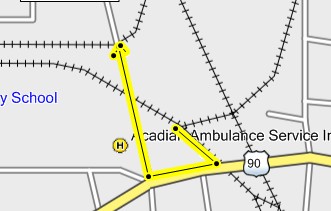
Those are the rails just above "A" in "Ambulance" on the map above.
They are the ones seen from Cameron St. I don't want anyone
getting lost. What's that on my elbow? I'll be back there today,
Monday, if I don't snooze off from being up at 2:45 AM and
writing up this junk.
I then went back to N.Pierce, took a right, crossed the live rails
where I had turned before and went to the second hump that had rails
on it. I'll be back because I didn't shoot both ways, duh, but there
was traffic and I was nervous being in such a wealth of historical
information all at once.
After crossing the main line I came to a second set of rails.
I say set because there were two. One may have been
to a spur. The other, I feel sure, was the old approach
from the west rails to the north rails or from Lake Charles
to the abandoned ones going to Alexandria. A jaw dropper
is coming up.

There they go bending north.
.jpg)
I next continued up N. Pierce and cut over to Buchanan.
I stopped there and parked in a driveway to a field which
lay along the tracks.

I shot this picture looking south back to the point of the
picture above the map. I had to park where you see the
"L" in Lafayette. The bike is at the yellow turn arrow in
the corner. This is the "End of Rails" point seen in a
previous map. From this point north, only the bed is
evidence all the way to Cheneyville. There had been
two sets of rails from the crossing, making the curve
to this point, maybe. It'll be on my "2du" list for today.
.jpg)
A man approached my bike on his tractor.

I ran back to the bike thinking he might need to get out of
his gate. He stopped and I asked him if he knew where the
roundhouse had been. He explained that he thought it was
off the Evangeline Thruway. That's all I could think to say
to him, at first. Then I asked if rail traffic still came up this way.
He said, "No, but could you help me fix my tractor"?
I agreed to and we spent the rest of the day and half the
next fixing his tractor. Then he asked me if I'd like to
sit on his front porch and rock a while. I told him thank you,
but I must be getting on with the rail hunt. He told me
to "take care" and for the rest of the ride, I did, making
sure to have no more personal contact.
Very sleepily I went down Buchanan, crossing the Baton
Rouge Branch, turned west on Cameron, crossed the old
Southern Pacific branch to Alexandria and then the live
rails to New Orleans and Lake Charles. I got off Cameron
onto Hopkins and then turned north on Washington where
I recrossed the live rails and then came to the Southern
Pacific connector that I'd been with on Buchanan. I was
starting to get the idea. I turned right on this dead end
street (now). and stopped, slack jawed.

I was slack jawed because I saw this. It, like the old I&V
Junction sign down in Vermillion Parish is a relic from the
past, just as the BR (Baton Rouge) sign is that you can see
at the end of the red arrow in the background. I had discovered
the Holly Grail of Lafayette Railroad History. I am still
slack jawed and shaking from the experience.

End of Page 2