It started while I contemplated how I was going to ride the Sunset Limited or maybe chase it. It seems to me that on Friday you can leave Lafayette at 10:15. Get off at Schriever and wait until 1:25 where the west bound will pick you up and bring you back to Lafayette for 1:45. Now, here's the problem, the east bound is coming from Los Angeles. Given the uncertainty that can occur, actually arriving at Schriever in time to catch the fresh train coming from New Orleans, may be a crap shoot with terrible odds. Sitting in Schiever with nothing to do and nowhere to go, you might want to get sedated. I know a bar there with a "floor show", a lovely place.

Not being Friday I decided to go to Lafayette anyway. This is the history that drew me there. Lafayette was geographically and geologically in the right place at the right time. The Southern Pacific Railroad built an expensive speculative rail line across some very difficult terrain, the untamed Atchafalaya Basin, to connect Lafayette with the population centers along the Mississippi River, the next dependably high ground going east. Another line came from the New Orleans area through Lafayette to reach Opelousas and eventually Alexandria. Another linked Texas with Lafayette. Lafayette was a transportation center. Here are a few old schedules. Southern Pacific, to the north, Lafayette to Alexandria 1915.

1926

M.L.&T. = Morgan's Louisiana and Texas RR. = the SP, later. Lafayette to Baton Rouge, the mentioned Basin Route, the east route. 1926, one year before the demise of the Atchafalaya River bridge at the settlement of Atchafalaya, site of the Welcome Center on I-10.

To Morgan City 1935, the southeast route ' eventually to New Orleans. (Click to Enlarge)

And to the west (1935). Click to read.

I knew where all of these rails converged but was very confused on how it was done. That confusion is born from my 2 different maps, one old and one new. It was 96F and the humidity was riding the wave of a couple of weeks of rain, weather perfect for stop and go urban warfare in the carbon monoxide and killer traffic. Remember, I'm on a motorcycle, the only way to do this properly. Old, probably in the mid-1970's. (Garmin GPS)

Present day arrangement (Garmin GPS):

Combining the two, I came up with this. Click for the full size version.

And from above. I have drawn in what I see from ground evidence.

What seems pretty close are the rails coming in from the west (red), and the rails going to Breaux Bridge (green) though there have been tweaks. There once was a double set of rails coming in from the west. The connector between the west rails and the north rails are strangely different when looking at the Garmin and the present reality on the ground today. Sometimes approximations are the best you can do. The problem with all of this is that I didn't study the maps until I tried to figure out where I took the pictures. This approach always requires a second trip to fill in the blanks and to verify assumptions. Further, you can't trust Garmin. Exact railroad interpretations are not their business. The trip will begin on the next page, to be done later. I decided to put the next page here since getting anyone to actually click to the next page, after this page, would have issues. I ventured into Lafayette to the living rail museum which is the Cameron / Mud Street, Washington St/ N.Pierce St, and Buchanan St. area. My first set of pictures were taken from Cameron Street where you see the red arrow. Some may say this is the arm pit of Lafayette. I may agree on some levels, but for investigating rail history, it is a gold mine.
.jpg)
The Legend: (no not me this time, the map's) Green: The Baton Rouge Branch, aka the Basin Branch. These rails now end at Breaux Bridge. Orange: BR (Baton Rouge Junction) Blue: N.Pierce and the existing UP/BNSF crossing. Yellow: The historic cross track of the BR rails and the Alexandria Branch of the Southern Pacific. Yellow Line: The SP to Alexandria. Yellow Arrow facing down points to the location of the present depot. Yes, again, below are maps of the Cameron Street Crossing area. The red arrows are the Baton Rouge Branch, still active, and the green arrows point to Cameron / Mud Streets. The road is named "Cameron on the west side of the tracks and "Mud" on the east. It's Lafayette, go figure. As a local teacher once told me, "The place was designed by cows". It was also diced up by the railroads and highways as pronounced by some thesis done at USL/ UL, what the hell. 1978
.jpg)
This is how it is now (2010 for those calendar challenged as I am whenever I write a check).
.jpg)
Here's an explanation: Remember, I was standing at the red arrow on the top map. I shot across Mud (east side of the main line) . The disappearing rails are the Southern Pacific remains going to Alexandria (the "Alex Jct" we'll see it on a sign later) and either a connector to the Baton Rouge Branch (to be investigated Monday) or a spur to a business seen in the background. Sunday would not be a good day unless early and I don't do "early".
.jpg)
Panning right (east), you can see the rails headed off to Breaux Bridge on the old Baton Rouge Branch.
.jpg)
Backing up and panning right, I got the historic and now unneeded crossing sign for the ripped up Southern Pacific Alexandria Branch. That's Bragg Street and Mud Ave.
.jpg)
Panning right again, south, off in the distance you can see the new depot. The old one was the the target of an arsonist, I think I remember. Nevertheless, it burned down.
.jpg)
Panning right, timing? Actually the train would appear a little later and we'll chase it to the underpass. I need to give you something to anticipate.
.jpg)
To view page one of this epic,
CLICK HERE. After last night's awesome visitor numbers, I am renewed to continue with this episode. From the Cameron and Bragg location, I crossed the tracks moving west. First the abandoned Southern Pacific ones and then the live BNSF ones, making a north turn onto N.Pierce St. I came to the live rails and took a right along the tracks on what I don't think was a road. I stopped directly across from the switch to the Baton Rouge (now Breaux Bridge) Branch.

Railroading seems to hang onto historic labeling. "BR" is for "Baton Rouge".
.jpg)
Yep.
.jpg)
Those are the rails just above "A" in "Ambulance" on the map above. They are the ones seen from Cameron St. I don't want anyone getting lost. What's that on my elbow? I'll be back there today, Monday, if I don't snooze off from being up at 2:45 AM and writing up this junk. I then went back to N.Pierce, took a right, crossed the live rails where I had turned before and went to the second hump that had rails on it. I'll be back because I didn't shoot both ways, duh, but there was traffic and I was nervous being in such a wealth of historical information all at once.

After crossing the main line I came to a second set of rails. I say set because there were two. One may have been to a spur. The other, I feel sure, was the old approach from the west rails to the north rails or from Lake Charles to the abandoned ones going to Alexandria. A jaw dropper is coming up.
.jpg)
There they go bending north.
.jpg)
I next continued up N. Pierce and cut over to Buchanan. I stopped there and parked in a driveway to a field which lay along the tracks.

I shot this picture looking south back to the point of the picture above the map. I had to park where you see the "L" in Lafayette. The bike is at the yellow turn arrow in the corner. This is the "End of Rails" point seen in a previous map. From this point north, only the bed is evidence all the way to Cheneyville. There had been two sets of rails from the crossing, making the curve to this point, maybe. It'll be on my "2du" list for today.
.jpg)
A man approached my bike on his tractor.

I ran back to the bike thinking he might need to get out of his gate. He stopped and I asked him if he knew where the roundhouse had been. He explained that he thought it was off the Evangeline Thruway. That's all I could think to say to him, at first. Then I asked if rail traffic still came up this way. He said, "No, but could you help me fix my tractor"? I agreed to and we spent the rest of the day and half the next fixing his tractor. Then he asked me if I'd like to sit on his front porch and rock a while. I told him thank you, but I must be getting on with the rail hunt. He told me to "take care" and for the rest of the ride, I did, making sure to have no more personal contact. Very sleepily I went down Buchanan, crossing the Baton Rouge Branch, turned west on Cameron, crossed the old Southern Pacific branch to Alexandria and then the live rails to New Orleans and Lake Charles. I got off Cameron onto Hopkins and then turned north on Washington where I recrossed the live rails and then came to the Southern Pacific connector that I'd been with on Buchanan. I was starting to get the idea. I turned right on this dead end street (now). and stopped, slack jawed.

I was slack jawed because I saw this. It, like the old I&V Junction sign down in Vermillion Parish is a relic from the past, just as the BR (Baton Rouge) sign is that you can see at the end of the red arrow in the background. I had discovered the Holly Grail of Lafayette Railroad History. I am still slack jawed and shaking from the experience.
.jpg)
Or, it may be that I need to get another cup of coffee. Just as I was getting ready to start a new leg of the hunt, I heard the whistle blow. I flew back to Cameron Street facing west as 3 big engines pulled around the west to south big bend and headed south. The next sequence is page 3. I'll give you time to catch your breath before I hit you with more history. And, I haven't made it back to Lafayette to fill in page 2. But, my yard's mowed and the wife is smiling. Back at Cameron/Mudd Sts.
.jpg)
Same
.jpg)
Same
.jpg)
Same, showing the Alexandria Branch tracks crossing Mudd on the way to parallel the siding for the depot. The train would merge with the Alexandria Branch to continue south, or, head into the station siding.
.jpg)
This is the 3rd Street crossing. It was the first road crossing north of the station. There was no Jefferson St. Crossing.
.jpg)
Same
.jpg)
Approaching the depot and getting ready to cross the Jefferson St. underpass.
.jpg)
Being a frivolous page, I simply traced a line down the map where the chase occurred. I dropped down Buchanan and did a jag onto N. Grant St., continuing until stopped by the under- pass on Jefferson and shot the depot with the train coming by. Writing this up, I decided to switch the maps over to the older version and I've discovered a few things. At first, this is all I was going to show you. This is the new map with my run down Buchanan and Grant to Jefferson.

Do you see where N.Buchanan changes or rather meets N.Grant? That is E.Simcoe seen in the map above. On the new map Buchanan does not cross the tracks until it uses the Simcoe crossing, seen below.

I get a little repetitious below. It's like I'm trying to convince myself. I once loved maps, no more. On the old map, below, Buchanan dives across the two sets of tracks. There was no east road next to the tracks past where it crossed until E. Simcoe where North Grant started shadowing the rails. Notice the jag in N. Grant where it crossed the siding rails and then it got closer to rails one block above where it turned hard east. The old map does not name the streets so I can't tell you whether the turn was Jefferson St. or not. Nevertheless, the Jefferson St. underpass was not yet a reality. The station would be at the end of the siding on the left of then the main line. (west rails)

On the new map, N.Buchanan drops south but does not cross the one set of rails until it uses the E. Simcoe crossing to do so, then it continues south as S. Buchanan. Grant Street follows the rails in an even drop with no waver since the east siding is no longer there. It is my belief that when the east set of rails, the ones that fed the Alexandria Branch, were removed, the city used some of that space to continue N. Buchanan south and to straighten out N.Grant all the way to the the Jefferson Street underpass where the yellow mark is. That was where I had to stop the train chase. Now, the active rails, if the GPS is right, occupy the old western siding which had dead ended at the depot, just past Third Street on the old map. The crossing north of the depot had been 3rd St. where there is still one. I'm sure there are other differences but I'm burned on this page which I thought would be a "pass". Have you seen this one, yet? It's a new version. Say you have and let's move on. By the way, the next crossing south of the station was Johnston Street, a wait then and a wait now.

More later with only one map. I hate to write stuff up when I don't have all the facts, but, if I don't write it up quickly after the ride, I will lose interest or I'll just send it off in an easy, got her done, email. I can save those as easily as I can save a web page so on my end it makes no difference. But, I'd rather share them with the world than with just the winos, prostitutes, organized crime members, crooked cops, and pimps on my mailing list. You're shocked? It's Al's fault. Those are his friends ever since he became Lt. Dave Robicheaux of the Iberia Sheriff's Dept. Below you see the yellow lines. They are my trail on the 8th. What I've added are points where I should take a second look. I want to verify Garmin's 2 rail approach from the west. I know Bump 2 is there. 3, 4, 5, 6, will have to be checked. I also want to gps the existing rails which might mean riding them on the bike. I've looked for a train schedule and can't find one so I guess I'll just wing it. The angled road above the tracks has a purpose. What was in that space between the tracks and the next road up, Anne St. Bump 5 and 6 are in the left portion of that area.

At Bump 3 was this, a beautiful building owned by some "produce supply" company. I love corrugated steel. I can't say for certain that it is at Bump 3. It might be between Bump 3 and Bump 4? That has to be determined. Don't ask me why.
.jpg)
At bump 4, or near, there was a bump equally high with no rails on it. Looking to the west this was the scene. That's the St. Anne field. Look at the map and follow a line along St. Anne over to the branch going to Breaux Bridge and once Baton Rouge. Did the SP just skip all that Lafayette jazz and head east? The streets seem to say so. One even jags to accommodate a 90 degree crossing.
.jpg)

Alas, as I've said, this is all speculative with no actual reference points marked. After checking out Anne's Field, I made the block back to the rails. This area is not on the Cleanliest City Award tour route and I did not stop until I reached Huval Street. I guess everyone was amazed to see a blue bike on these streets. I guess they don't like blue. For some reason I made another block and came back to Walker Road, the location of what is called West Yard on the old schedules I showed you on page one. (BTW, those were courtesy of Everett Lueck andI'll have to send him 50c each for them or plug the Southern Forest Heritage Museum at Glenmora/Longleaf, yet one more time). Below is the old map's interpretation.


This is from outer space: It's large if you want to click it. What it shows is the Walker Rd Lafayette Power Plant across the road. There is a spur that at one time, not long ago, appeared active. I'm not sure how far back it went. I can only speculate what it delivered or hauled off.

Here's what I saw there:
.jpg)
.jpg)
They did not cross the road, but had not long ago. Here's the yard. I'm pressed for time so take the self- guided tour.
.jpg)
.jpg)
.jpg)
.jpg)
.jpg)
.jpg)
.jpg)
.jpg)
.jpg)
I proceeded on until I found the spur that went up into the back of my favorite, Southwest Scrap and Salvage. I actually sold something there.
.jpg)
.jpg)
.jpg)
.jpg)
The Railroad Museum area of Lafayette is not really the armpit of town, Scott Road is. It is as nasty industrial as it gets. It is layered in refuse from a number of oil booms and busts plus the other industries such as the scrap yards and car junk yards, you get the picture. It even had a roach infested bakery where I once worked. The railroad fits well there. The ugly keep the economy going, rose gardens don't. I'm calling this one off as I'm tired of it. Hope you got some- thing from it. More later.
.jpg)
I turned north at Scott to head to Opelousas where I hit some more tracks. Them later. They are in the Yellow Choo Choos read. To continue hunting in downtown Lafayette,
CLICK HERE.
.jpg)
I walked out of the house this afternoon about one o'clock expecting the heat and humidity to knock me down. Not so. It may have only been 80F. I knew there must be rain near but I didn't see any action aloft that might keep me home. For those that are questioning my first appearance outside at such a late hour, I was vacuuming. You got any problem with that? I decided that while I still had the boiler stoked on the Lafayette Hunt, I better get it done, and why not on such a mild afternoon. I headed back to the great cross roads of Lafayette railroading, the Cameraon Street / Mudd Avenue juncture. The GE map below is pretty large. I suggest you click on it and open it in a new window, set it to the side and refer to it as I try to share my excitement. If you are not railroad inclined, go watch Beck, O'Reilly or Hannity. You will fare better and learn more but they may put you in a bad mood. We need to be in a bad mood. I don't think you'll have to expand these after all. The one below is the old map ware again. To review, Southern Pacific came in from the west. The rails are still alive with only one set now which bends south to New Iberia and New Orleans. The line coming from the north was also a SP Branch going to Alexandria by way of Cheneyville. The rails to the east are the Baton Rouge Branch going there by way of the Atchafalaya swamp and the Missouri Pacific ferry at Anchorage. I'm not getting into the present and who is doing what with what's left over from the past. This page will be only a few pictures of what I found on the ground and had to explain to a cop. By the way, the best way to make a cop lose interest in you is to start talking old train history. He wanted to leave so badly I felt sorry for him but did not let up until I told him everything I knew about everything I knew. Actually, that was a story. The cop stopped to check out my bike since I was not around and it was parked where normal people don't park. I told him I appreciated it because it might be my bike that was stolen and he found it. He asked what I meant by "it might be my bike". I told him it was my bike and it wasn't stolen but it might be. He asked why did I think it might be. I told him that it might be because of where I parked it except that public heroes such as himself were checking on it. We all grinned knowing there wasn't much more to be said on the subject and the BS was about hubcap height and rising. His next step would be to book me for impersonating an owner of a stolen motorcycle. After that, he did leave. Have you left yet? I like to weed out the less than serious.
.jpg)
This one you may want to expand in a new window. I continued the hunt at "2X". "B1" is where I parked my bike and talked to the policeman. You can't find it, can you? You have to right click it and choose open in a new window.
.jpg)
I'm so afraid this is getting tedious. To help liven up the pictures, I've added arrows. I want this to be completely clear when you go by to visit. BTW, there's a real nice lady that runs an aluminum can salvage business right where I parked. She also turned me in to the cop when he asked her about the bike so don't start nothing or she'll bust ya. This is where the bike was parked. (B1) That's Mudd Ave. behind it. I figured it was a good place to park. Sure was a lot of limestone around. Yep, I was in the sweet spot of Lafayette Railroading.
.jpg)
We'll go to the other side of Mudd to get you oriented. I originally thought that I had found some very important branch of the Southern Pacific, and it still may be, but I don't think so. The arrow pointing straight across the road marks the SP on its way to Alexandria. The arrow pointing at the building is suppose to be pointing at the rails veering off to the left to only businesses on N. Pierce, I think. It is the very hard to see purple line on the Earth Page. The arrow pointing straight down is pointing at the screened building. It will become very important in your orientation. If you don't open that map you'll be lost.
.jpg)
Below: Crossing the road and looking back across the street, you see this. Straight down line is the SP going south. Slanted line is the business spur. Not seen is the screened building.
.jpg)
Turning back around and looking north you see this. This is where the Alexandria Branch gets ready to cross The Baton Rouge Branch going north. The screened building to the left separates the SP from the spur. The other arrow points to a boxcar. It is at Mike Baker Brick on N.Buchanan. We'll go by there when we clear this area. Remember it.
.jpg)
Emerging from the grass are the SP rails. I'd hoped to find the actual cross track in the grass but it was gone. Unfortunately, this is the less spectacular of the two cross- ings, but still spectacular to me. Rails not only offered to the regular person a connection with far off exotic places, like Opelousas, but a place to walk. I'd do some of that today. You do see the box car? It's on a siding. I'm still uneasy about it only being a siding.
.jpg)
Here's looking from the north side. That's a good shot of the screened building.
.jpg)
This is the west side of the screened building. It is what I think is only a spur. Here we see where a major route is crossed by a spur. It really seemed like a dangerous practice, but it is done twice in a matter of blocks. This is the spur, screened building and aluminum can business on the left. I bravely walked right through those weeds.
.jpg)
I came upon this. The rails continue, but stop, I did check. Green arrow goes to the main line at BR Junction. Red arrow points to Baton Rouge. Yellow arrow point to the business it goes to.
.jpg)
Here's a closer look. Still with me?
.jpg)
Looking to the west (left) on the BR, you see it approaching the main line. The arrow points to the junction.
.jpg)
Turning to the east (right), this is the picture. You can see the spur rails crossing the BR and the back of the screened building.
.jpg)
If not clear on this, the red line is the spur crossing the BR. The purple line is the SP. The red arrow pointing right is an arrow pointing at the screened building. The arrow pointing left is pointing north where the Alexandria Branch of the Southern Pacific Railroad went.
.jpg)
I walked north on the SP. I was not happy with what I've been calling the BR. I think this is a realignment. I think the actual bend occurred further north, but probably not. I know there was something else further north but I'm not getting into it on this page. There is so much more real with which to deal. I only deal with the surreal when I'm done with the real. Was a time I did it the other way around. Maybe I still do? It's a requirement at times. I was looking for humps coming in from the left and out to the right or visa versa. Here's another chance to see Mike Baker's boxcar just to keep it real.
.jpg)
I don't know. I had marked the old cross track on my gps, but it is so far off it can't be trusted. In the distance, in front of the white house are the present BR rails curving toward BR to the left. This is looking east. I was standing where the gps said the cross was. Maybe?
.jpg)
To the west was this. If old, it kind of blows my theory. I should have brought my chain saw, machete, and lawn mower, plus some bags to pick up all the refuse. But then the place would lose its charm.
.jpg)
All right, we are going back on the south side of Mudd Ave. There's stuff there. First point of interest is a switch (plant). It owes its existence to its ability to camouflage itself. Leave it alone. It is in its original home and happy living out its day daydreaming of good times gone by and laughing at the tourist. The trains still go by, if not a little different from the good old days.
.jpg)
I walked toward the depot, south. I'm not sure I did such a good job. I think the new rails didn't at all follow the old. Either that, or the new ones occupy the rails that originally went to the depot and the through rails were the Alexandria Branch's. These where the original main line, the Alex Branch. There is the signal light base, the depot and a side track, maybe.
.jpg)
Backing up a bit, this is what you see. I' m standing on sunken ties. This is not the side track shown on the map.
.jpg)
This is what you see past where the rails end. This is where I feel I slacked off. It's a neat area, I don't mind going back. I carry an opened eight inch knife in my pocket.
.jpg)
Heading back toward Mudd Ave. I have some stuff to point out. Arrow in front, pointing down...that's the bed with the sunken ties. I think it joined the main line before that beige building. Arrow pointing at the tree is pointing in the direction of the SP Alex Branch. Arrow to the left pointing down is at the Mudd Ave. crossing of the main line.
.jpg)
A closer look and a pop quiz.
.jpg)
This is a teaser for tomorrow.
.jpg)
That's it for page 1 of Icing the Cake. Tomorrow I have another layer to do. We go up to Buchanan St. and back to the Alex as she heads further north. We'll check out Mike Baker Brick and the field from the north end. We'll see were another spur crossed a main line, mercy, I may have nightmares. Sorry if I scarred you, too. More later. Evidently, there is no one to scare off. The rest of the pictures are on page 2.
CLICK HERE, But that's it. This is the legend: Red line from the north is the SP coming from Alexandria by way of Cheneyville, Washington, Opelousas, Sunset, and Carencro, (where Michael B.'s uncle was station agent). The leg going left is the main SP line going west to Lake Charles and ultimately, Los Angeles. The blue line is the SP going east to Baton Rouge. The green line is the Mike Baker Brick spur off the Alex Main. The purple line, near where the blue crossed the red, is a spur to a beer company. It is the first instance of where I found a spur crossing a main branch. This would be found UNTRUE. A revelation would occur. Green is the second instance. It comes off the main SP line (yellow) and goes north across the Alexandria Branch connector (red) and services yet another beer company. How many wrecks were there at these crossings? This spur became needed after something happened. I speculate that a set of rails was removed and this crossing didn't matter much because the SP north did not exist anymore. This map expands, open in a new window after you right click it.
.jpg)
I rode from where I had parked and had the nice visit with Officer Friendly. (By the way, there really was an Officer Friendly on the Lafayette P.D. He was a champ of a guy. Several of my co mechanics spoke of him well. He would let you go, but demanded a signed in blood agreement to behave. The mechanics needed transfusions daily. My destination was the bend in N. Buchanan St. It is at the top of the blue line (the SP going to Baton Rouge, now Breaux Bridge). It is near the UPS location. The straight white line is my theory. One that I insist is correct. This is it: The Southern Pacific had a straight bypass from its western route, across the top of Lafayette, to its eastern route to Baton Rouge. There is no doubt. Arriving there, I looked east toward the SP rails which can be barely seen skirting the trees to the right and straightening out going through that opening straight ahead. That is where the cross over would connect. I further don't believe that the present arrangement connected to the rails coming in from the west, but connected to the SP rails coming from the south. That will be clearly seen in one of the hundred maps here. This I may waver on. But it is possible. The present configuration is so weird and seems like an after thought.
.jpg)
Zoomed in you can see the now straight rails headed to Breaux Bridge. At the edge of the wood, they curve right. Grandmother's house is near.
.jpg)
Turning around, this is the scene. The open area continues west, crossing N. Pierce and Washington Sts.
.jpg)
Above, you are looking at N. Buchanan going to N.Pierce. In the past it bent more to the north. UPS now occupies that area. Below is the older map with N. Buchanan at a greater angle. Was that angle to facilitate a connector from the BR Branch to the Alexandria Branch? I got money on it. The streets fit, the open fields fit. Your call.

This is the "ROW" continuing across Washington to the SP main line headed to Lake Charles, hump and all. You can't dispute the humps.
.jpg)
Behind me, on Washington St, at the mystery hump, is this. It is the beer dealership the green line on the map goes to.
.jpg)
Now here's my theory on that. When the white line cut across (below) was active, the green line (beer dealer) connected to it and there was no need to cross the red main connector to the Alexandria Branch. A simple spur off the white cut across would do. Further, you can see where the blue line once shot south instead of bending across the old red Alex line and connecting with the yellow rails to Lake Charles. That explains the all the limestone where I parked my bike on Mudd Ave. I was parked on the Baton Rouge connector to the main SP line to New Orleans. B1 on the map. "B" is for "bike".
Below: One more epiphany. The green arrows point to switch positions in the old set up. Remember my saying that the line to the left crossing Mudd Ave went only to a business?
I was wrong. Forget about the present rails. They have replaced both of the old sets going west. The rails to the left, starting at the end of the long green arrow, were the main line through town going south. The short arrow was to a dead end spur to the depot. Depots got spurs, even small one. Now, the epiphany. The switch with the pretty vine is, drum roll, the main line switch. And, while your imagination is working draw in your mind a line from the end of the long green arrow to the BR branch that is bending east and you'll have the old setup. I'll do a full theory map later.
That covers the UPS bend of N. Buchanan. Below are 2 maps of the same place. The first is the new set up. The last pictures of the BR branch headed off to Breaux Bridge and my theorized cut across headed to Washington Street were taken from where you see the "N" for North Buchanan St. N. Buchanan now bends southward and aligns with Madeline Ave. It didn't when my theorized connector went from the BR branch across north Lafayette and hit the west bound SP near Helen St.

The green arrow, below, points to Madeline Ave. The green arrow, above, points to where I parked the bike. Remember, I'd been here before and talked to the farmer.

I can't stretch your imagination anymore. Here's the scene. I'm parked approximately where the stub end of the blue arrow is. (not the pointed end) Remember the Madeline alignment.
.jpg)
Since the farmer and I were best of buddies, I figured he wouldn't mind if I strolled his field a little. The roadway is N.Buchanan aligning with Madeline, white car to the left. Paralleling the rails is or was called Railroad St. I want to ride it later. Al wants to go. Below is the switch at the pointed end of the blue arrow.
.jpg)
Turning around, this is what you see. The rails going straight are the SP Alexandria going into Lafayette. The rails to the right are the connector rails of yesterday. My theorized cut across would have cut across a little north of where the connector starts turning west.
.jpg)
Walking south. The old connector has become torn up and only the sunken ties can be seen.
.jpg)
Notice the spur and switch to Mike Baker Brick to the left.
.jpg)
I was getting pretty far from my bike and getting nervous. This is what I think. Since the original connector was torn up, the SP main line was cut and bent to the west to become the way to get to Mike Baker. The SP main once continued straight to first place I parked, later crossing the tweaked Baton Rouge branch. Tweaked means bent or twisted in motorcycle language. I revert to it when other languages fail me. What they did, I think, was to grab the approach to the straight line running from the west incoming rails to the east, Baton Rouge Branch and bend them up so that traffic from the west could enter the BR Branch when the cut across was gone. I know, I'm dizzy, too. I'm talking about the yellow line to the right. I say it went straight down and didn't hook to the left ORIGINALLY.

.jpg)
Getting thick? Here's a simple picture of the Mike Baker switch which means I walked down that far.
.jpg)
.jpg)
Below was taken from the other end of the field. The SP would be to the left along that tree line.
.jpg)
Here the converted main line follows the deserted connector around to N. Pierce St.
.jpg)
I'm really lucky I didn't have my bike stolen. A car stopped as I was walking back. He was trying to figure out how he was going to drive his car and my bike home. I had walked a ways. N. Pierce was just in sight. I turned at exactly the right moment.
.jpg)
This picture was taken earlier. It is looking west at the converted SP main line approaches the SP rails to Lake Charles. Remember that red brick building. It is where we see the sign "Alex Jct.", where these rails are headed.
.jpg)
I turned around and felt a need to shoot the walk back. That's the Mike Baker switch. The bike is just to the right of it in the distance.
.jpg)
A black car approached. The bike is at about 1:oo.
.jpg)
It stopped. I sprinted holding my 8'' blade with a 8" handle high waving it like a peyote deranged banshee having a bad day. It was a cop in an unmarked car. Now for a review Remember the Washington Street mystery bump?
And the beer distributorship which sat next to it?
And the Alexandria Junction sign where the rails we were following a minute ago ended up?
.jpg)
And the red brick building I told you to remember?
.jpg)
And the fact that there was a second place where a spur crossed a main line? In the forefront are the active rails of the Union Pacific / BNSF (do I have that right?) coming from Lake Charles and headed to New Iberia. The curved rails are coming from the Alexandria Junction sign area and curving around to cross N. Pierce and end up where I just was, next to my bike explaining my knife. Oh, and the spur that crosses the connector. I wonder what that sign says? "Don't engineer drunk"?.
.jpg)
I don't know why I felt a need for all these angles. OK, it's because I need them. The spur seemed to curve around to a loading dock. Did they fill tank cars with beer? Wow, sounds like a great party. How would you ice a tank car down?
.jpg)
Remember the red building seen from the field when I was theorizing on another connection alignment. Don't even think about it. Down to the right of the pink building is where the rails I thought was a business spur ran. They, in reality were the original main line rails which were slightly above the new main line curve into Lafayette.
.jpg)
Green arrow points to the cut tracks, rails on each side that we found by the screened building. Blue arrow points to where the pink building is, approximately. BTW, the two parallel rails running west join at the yard west of Lafayette.

Back to the beer distributorship for the rest of the views. This is looking north. At the top is Alex Junction. Crossing the spur is the Alex connector. Straight ahead is BEER.
.jpg)
As I have harped, the main line today is not the main line of yesterday. I used my two maps to illustrate something about the SP's old bend west that came by that pink building.
.jpg)
There was never a cross track there. The old SP main line was broken to allow the new alignment of the rails to Breaux Bridge, probably by Louisiana Delta. The new curve is just that, a new curve. My feelings on the mild hump in the field were probably right. I'll have to apologize to my GPS for saying she was sloppy. The picture below is of the cut main line looking toward Breaux Bridge. 25 feet down the line, the Alexandria rails were broken. The cross did not happen there. The cut rails are the original curve going into Lafayette.
.jpg)
A review. Here is where the curve from Lake Charles hit the Alexandria Branch, where this hunt all started, it seems like weeks ago.
.jpg)
This is a holy place.
.jpg)
This is the new map. I say the intersection is No.9. No.5 is the switch to the depot. No.4 is where the broken rails are.
.jpg)
Here's the old map. What difference does one more map make? There you go. I think I get it now. 5 to 6 are very close to the existing rails though I don't think that bed is used.

And, the pink building was not there when the old curve was used. Now what they are calling BR Junction is not really Baton Rouge Junction. It's been moved.
Now I'll try a trick if I can remember all that I've theorized. The orange is what I found. The white is the old track alignment. The white with red tracer is all speculative. The large version is at the company store.
.jpg)
WTH, I had a map left over. What's one more map?
Now a message from our sponsor.
 Not being Friday I decided to go to Lafayette anyway. This is the history that drew me there. Lafayette was geographically and geologically in the right place at the right time. The Southern Pacific Railroad built an expensive speculative rail line across some very difficult terrain, the untamed Atchafalaya Basin, to connect Lafayette with the population centers along the Mississippi River, the next dependably high ground going east. Another line came from the New Orleans area through Lafayette to reach Opelousas and eventually Alexandria. Another linked Texas with Lafayette. Lafayette was a transportation center. Here are a few old schedules. Southern Pacific, to the north, Lafayette to Alexandria 1915.
  1926
1926  M.L.&T. = Morgan's Louisiana and Texas RR. = the SP, later. Lafayette to Baton Rouge, the mentioned Basin Route, the east route. 1926, one year before the demise of the Atchafalaya River bridge at the settlement of Atchafalaya, site of the Welcome Center on I-10.
  To Morgan City 1935, the southeast route ' eventually to New Orleans. (Click to Enlarge)
  And to the west (1935). Click to read.
  I knew where all of these rails converged but was very confused on how it was done. That confusion is born from my 2 different maps, one old and one new. It was 96F and the humidity was riding the wave of a couple of weeks of rain, weather perfect for stop and go urban warfare in the carbon monoxide and killer traffic. Remember, I'm on a motorcycle, the only way to do this properly. Old, probably in the mid-1970's. (Garmin GPS)
  Present day arrangement (Garmin GPS):
  Combining the two, I came up with this. Click for the full size version.
  And from above. I have drawn in what I see from ground evidence.
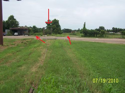
  What seems pretty close are the rails coming in from the west (red), and the rails going to Breaux Bridge (green) though there have been tweaks. There once was a double set of rails coming in from the west. The connector between the west rails and the north rails are strangely different when looking at the Garmin and the present reality on the ground today. Sometimes approximations are the best you can do. The problem with all of this is that I didn't study the maps until I tried to figure out where I took the pictures. This approach always requires a second trip to fill in the blanks and to verify assumptions. Further, you can't trust Garmin. Exact railroad interpretations are not their business. The trip will begin on the next page, to be done later. I decided to put the next page here since getting anyone to actually click to the next page, after this page, would have issues. I ventured into Lafayette to the living rail museum which is the Cameron / Mud Street, Washington St/ N.Pierce St, and Buchanan St. area. My first set of pictures were taken from Cameron Street where you see the red arrow. Some may say this is the arm pit of Lafayette. I may agree on some levels, but for investigating rail history, it is a gold mine.
  The Legend: (no not me this time, the map's) Green: The Baton Rouge Branch, aka the Basin Branch. These rails now end at Breaux Bridge. Orange: BR (Baton Rouge Junction) Blue: N.Pierce and the existing UP/BNSF crossing. Yellow: The historic cross track of the BR rails and the Alexandria Branch of the Southern Pacific. Yellow Line: The SP to Alexandria. Yellow Arrow facing down points to the location of the present depot. Yes, again, below are maps of the Cameron Street Crossing area. The red arrows are the Baton Rouge Branch, still active, and the green arrows point to Cameron / Mud Streets. The road is named "Cameron on the west side of the tracks and "Mud" on the east. It's Lafayette, go figure. As a local teacher once told me, "The place was designed by cows". It was also diced up by the railroads and highways as pronounced by some thesis done at USL/ UL, what the hell. 1978
  This is how it is now (2010 for those calendar challenged as I am whenever I write a check).
  Here's an explanation: Remember, I was standing at the red arrow on the top map. I shot across Mud (east side of the main line) . The disappearing rails are the Southern Pacific remains going to Alexandria (the "Alex Jct" we'll see it on a sign later) and either a connector to the Baton Rouge Branch (to be investigated Monday) or a spur to a business seen in the background. Sunday would not be a good day unless early and I don't do "early".
 .jpg) Panning right (east), you can see the rails headed off to Breaux Bridge on the old Baton Rouge Branch.
Panning right (east), you can see the rails headed off to Breaux Bridge on the old Baton Rouge Branch. .jpg) Backing up and panning right, I got the historic and now unneeded crossing sign for the ripped up Southern Pacific Alexandria Branch. That's Bragg Street and Mud Ave.
Backing up and panning right, I got the historic and now unneeded crossing sign for the ripped up Southern Pacific Alexandria Branch. That's Bragg Street and Mud Ave. .jpg) Panning right again, south, off in the distance you can see the new depot. The old one was the the target of an arsonist, I think I remember. Nevertheless, it burned down.
Panning right again, south, off in the distance you can see the new depot. The old one was the the target of an arsonist, I think I remember. Nevertheless, it burned down. .jpg) Panning right, timing? Actually the train would appear a little later and we'll chase it to the underpass. I need to give you something to anticipate.
Panning right, timing? Actually the train would appear a little later and we'll chase it to the underpass. I need to give you something to anticipate. .jpg) To view page one of this epic, CLICK HERE. After last night's awesome visitor numbers, I am renewed to continue with this episode. From the Cameron and Bragg location, I crossed the tracks moving west. First the abandoned Southern Pacific ones and then the live BNSF ones, making a north turn onto N.Pierce St. I came to the live rails and took a right along the tracks on what I don't think was a road. I stopped directly across from the switch to the Baton Rouge (now Breaux Bridge) Branch.
To view page one of this epic, CLICK HERE. After last night's awesome visitor numbers, I am renewed to continue with this episode. From the Cameron and Bragg location, I crossed the tracks moving west. First the abandoned Southern Pacific ones and then the live BNSF ones, making a north turn onto N.Pierce St. I came to the live rails and took a right along the tracks on what I don't think was a road. I stopped directly across from the switch to the Baton Rouge (now Breaux Bridge) Branch.  Railroading seems to hang onto historic labeling. "BR" is for "Baton Rouge".
  Yep.
Yep. .jpg) Those are the rails just above "A" in "Ambulance" on the map above. They are the ones seen from Cameron St. I don't want anyone getting lost. What's that on my elbow? I'll be back there today, Monday, if I don't snooze off from being up at 2:45 AM and writing up this junk. I then went back to N.Pierce, took a right, crossed the live rails where I had turned before and went to the second hump that had rails on it. I'll be back because I didn't shoot both ways, duh, but there was traffic and I was nervous being in such a wealth of historical information all at once.
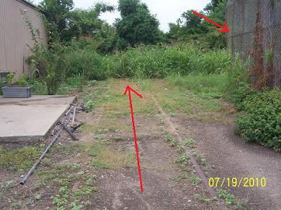
Those are the rails just above "A" in "Ambulance" on the map above. They are the ones seen from Cameron St. I don't want anyone getting lost. What's that on my elbow? I'll be back there today, Monday, if I don't snooze off from being up at 2:45 AM and writing up this junk. I then went back to N.Pierce, took a right, crossed the live rails where I had turned before and went to the second hump that had rails on it. I'll be back because I didn't shoot both ways, duh, but there was traffic and I was nervous being in such a wealth of historical information all at once. 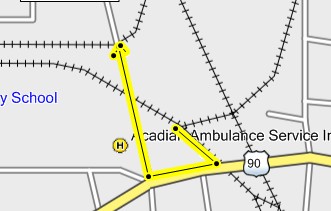 After crossing the main line I came to a second set of rails. I say set because there were two. One may have been to a spur. The other, I feel sure, was the old approach from the west rails to the north rails or from Lake Charles to the abandoned ones going to Alexandria. A jaw dropper is coming up.
  There they go bending north.
 .jpg) I next continued up N. Pierce and cut over to Buchanan. I stopped there and parked in a driveway to a field which lay along the tracks.
I next continued up N. Pierce and cut over to Buchanan. I stopped there and parked in a driveway to a field which lay along the tracks.  I shot this picture looking south back to the point of the picture above the map. I had to park where you see the "L" in Lafayette. The bike is at the yellow turn arrow in the corner. This is the "End of Rails" point seen in a previous map. From this point north, only the bed is evidence all the way to Cheneyville. There had been two sets of rails from the crossing, making the curve to this point, maybe. It'll be on my "2du" list for today.
 .jpg) A man approached my bike on his tractor.
A man approached my bike on his tractor.  I ran back to the bike thinking he might need to get out of his gate. He stopped and I asked him if he knew where the roundhouse had been. He explained that he thought it was off the Evangeline Thruway. That's all I could think to say to him, at first. Then I asked if rail traffic still came up this way. He said, "No, but could you help me fix my tractor"? I agreed to and we spent the rest of the day and half the next fixing his tractor. Then he asked me if I'd like to sit on his front porch and rock a while. I told him thank you, but I must be getting on with the rail hunt. He told me to "take care" and for the rest of the ride, I did, making sure to have no more personal contact. Very sleepily I went down Buchanan, crossing the Baton Rouge Branch, turned west on Cameron, crossed the old Southern Pacific branch to Alexandria and then the live rails to New Orleans and Lake Charles. I got off Cameron onto Hopkins and then turned north on Washington where I recrossed the live rails and then came to the Southern Pacific connector that I'd been with on Buchanan. I was starting to get the idea. I turned right on this dead end street (now). and stopped, slack jawed.
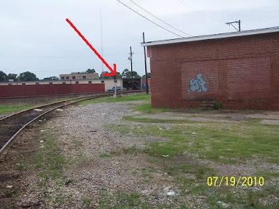
  I was slack jawed because I saw this. It, like the old I&V Junction sign down in Vermillion Parish is a relic from the past, just as the BR (Baton Rouge) sign is that you can see at the end of the red arrow in the background. I had discovered the Holly Grail of Lafayette Railroad History. I am still slack jawed and shaking from the experience.
  Or, it may be that I need to get another cup of coffee. Just as I was getting ready to start a new leg of the hunt, I heard the whistle blow. I flew back to Cameron Street facing west as 3 big engines pulled around the west to south big bend and headed south. The next sequence is page 3. I'll give you time to catch your breath before I hit you with more history. And, I haven't made it back to Lafayette to fill in page 2. But, my yard's mowed and the wife is smiling. Back at Cameron/Mudd Sts.
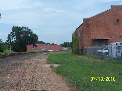
 .jpg) Same
Same .jpg) Same
Same .jpg) Same, showing the Alexandria Branch tracks crossing Mudd on the way to parallel the siding for the depot. The train would merge with the Alexandria Branch to continue south, or, head into the station siding.
Same, showing the Alexandria Branch tracks crossing Mudd on the way to parallel the siding for the depot. The train would merge with the Alexandria Branch to continue south, or, head into the station siding. .jpg) This is the 3rd Street crossing. It was the first road crossing north of the station. There was no Jefferson St. Crossing.
This is the 3rd Street crossing. It was the first road crossing north of the station. There was no Jefferson St. Crossing. .jpg) Same
Same .jpg) Approaching the depot and getting ready to cross the Jefferson St. underpass.
Approaching the depot and getting ready to cross the Jefferson St. underpass. .jpg) Being a frivolous page, I simply traced a line down the map where the chase occurred. I dropped down Buchanan and did a jag onto N. Grant St., continuing until stopped by the under- pass on Jefferson and shot the depot with the train coming by. Writing this up, I decided to switch the maps over to the older version and I've discovered a few things. At first, this is all I was going to show you. This is the new map with my run down Buchanan and Grant to Jefferson.
Being a frivolous page, I simply traced a line down the map where the chase occurred. I dropped down Buchanan and did a jag onto N. Grant St., continuing until stopped by the under- pass on Jefferson and shot the depot with the train coming by. Writing this up, I decided to switch the maps over to the older version and I've discovered a few things. At first, this is all I was going to show you. This is the new map with my run down Buchanan and Grant to Jefferson.  Do you see where N.Buchanan changes or rather meets N.Grant? That is E.Simcoe seen in the map above. On the new map Buchanan does not cross the tracks until it uses the Simcoe crossing, seen below.
  I get a little repetitious below. It's like I'm trying to convince myself. I once loved maps, no more. On the old map, below, Buchanan dives across the two sets of tracks. There was no east road next to the tracks past where it crossed until E. Simcoe where North Grant started shadowing the rails. Notice the jag in N. Grant where it crossed the siding rails and then it got closer to rails one block above where it turned hard east. The old map does not name the streets so I can't tell you whether the turn was Jefferson St. or not. Nevertheless, the Jefferson St. underpass was not yet a reality. The station would be at the end of the siding on the left of then the main line. (west rails)
  On the new map, N.Buchanan drops south but does not cross the one set of rails until it uses the E. Simcoe crossing to do so, then it continues south as S. Buchanan. Grant Street follows the rails in an even drop with no waver since the east siding is no longer there. It is my belief that when the east set of rails, the ones that fed the Alexandria Branch, were removed, the city used some of that space to continue N. Buchanan south and to straighten out N.Grant all the way to the the Jefferson Street underpass where the yellow mark is. That was where I had to stop the train chase. Now, the active rails, if the GPS is right, occupy the old western siding which had dead ended at the depot, just past Third Street on the old map. The crossing north of the depot had been 3rd St. where there is still one. I'm sure there are other differences but I'm burned on this page which I thought would be a "pass". Have you seen this one, yet? It's a new version. Say you have and let's move on. By the way, the next crossing south of the station was Johnston Street, a wait then and a wait now.
  More later with only one map. I hate to write stuff up when I don't have all the facts, but, if I don't write it up quickly after the ride, I will lose interest or I'll just send it off in an easy, got her done, email. I can save those as easily as I can save a web page so on my end it makes no difference. But, I'd rather share them with the world than with just the winos, prostitutes, organized crime members, crooked cops, and pimps on my mailing list. You're shocked? It's Al's fault. Those are his friends ever since he became Lt. Dave Robicheaux of the Iberia Sheriff's Dept. Below you see the yellow lines. They are my trail on the 8th. What I've added are points where I should take a second look. I want to verify Garmin's 2 rail approach from the west. I know Bump 2 is there. 3, 4, 5, 6, will have to be checked. I also want to gps the existing rails which might mean riding them on the bike. I've looked for a train schedule and can't find one so I guess I'll just wing it. The angled road above the tracks has a purpose. What was in that space between the tracks and the next road up, Anne St. Bump 5 and 6 are in the left portion of that area.
  At Bump 3 was this, a beautiful building owned by some "produce supply" company. I love corrugated steel. I can't say for certain that it is at Bump 3. It might be between Bump 3 and Bump 4? That has to be determined. Don't ask me why.
 .jpg) At bump 4, or near, there was a bump equally high with no rails on it. Looking to the west this was the scene. That's the St. Anne field. Look at the map and follow a line along St. Anne over to the branch going to Breaux Bridge and once Baton Rouge. Did the SP just skip all that Lafayette jazz and head east? The streets seem to say so. One even jags to accommodate a 90 degree crossing.
At bump 4, or near, there was a bump equally high with no rails on it. Looking to the west this was the scene. That's the St. Anne field. Look at the map and follow a line along St. Anne over to the branch going to Breaux Bridge and once Baton Rouge. Did the SP just skip all that Lafayette jazz and head east? The streets seem to say so. One even jags to accommodate a 90 degree crossing. .jpg)
 Alas, as I've said, this is all speculative with no actual reference points marked. After checking out Anne's Field, I made the block back to the rails. This area is not on the Cleanliest City Award tour route and I did not stop until I reached Huval Street. I guess everyone was amazed to see a blue bike on these streets. I guess they don't like blue. For some reason I made another block and came back to Walker Road, the location of what is called West Yard on the old schedules I showed you on page one. (BTW, those were courtesy of Everett Lueck andI'll have to send him 50c each for them or plug the Southern Forest Heritage Museum at Glenmora/Longleaf, yet one more time). Below is the old map's interpretation.
  This is from outer space: It's large if you want to click it. What it shows is the Walker Rd Lafayette Power Plant across the road. There is a spur that at one time, not long ago, appeared active. I'm not sure how far back it went. I can only speculate what it delivered or hauled off.
  Here's what I saw there:
 .jpg)
.jpg) They did not cross the road, but had not long ago. Here's the yard. I'm pressed for time so take the self- guided tour.
They did not cross the road, but had not long ago. Here's the yard. I'm pressed for time so take the self- guided tour. .jpg)
.jpg)
.jpg)
.jpg)
.jpg)
.jpg)
.jpg)
.jpg)
.jpg) I proceeded on until I found the spur that went up into the back of my favorite, Southwest Scrap and Salvage. I actually sold something there.
I proceeded on until I found the spur that went up into the back of my favorite, Southwest Scrap and Salvage. I actually sold something there. .jpg)
.jpg)
.jpg)
.jpg) The Railroad Museum area of Lafayette is not really the armpit of town, Scott Road is. It is as nasty industrial as it gets. It is layered in refuse from a number of oil booms and busts plus the other industries such as the scrap yards and car junk yards, you get the picture. It even had a roach infested bakery where I once worked. The railroad fits well there. The ugly keep the economy going, rose gardens don't. I'm calling this one off as I'm tired of it. Hope you got some- thing from it. More later.
The Railroad Museum area of Lafayette is not really the armpit of town, Scott Road is. It is as nasty industrial as it gets. It is layered in refuse from a number of oil booms and busts plus the other industries such as the scrap yards and car junk yards, you get the picture. It even had a roach infested bakery where I once worked. The railroad fits well there. The ugly keep the economy going, rose gardens don't. I'm calling this one off as I'm tired of it. Hope you got some- thing from it. More later. .jpg) I turned north at Scott to head to Opelousas where I hit some more tracks. Them later. They are in the Yellow Choo Choos read. To continue hunting in downtown Lafayette, CLICK HERE.
I turned north at Scott to head to Opelousas where I hit some more tracks. Them later. They are in the Yellow Choo Choos read. To continue hunting in downtown Lafayette, CLICK HERE. .jpg) I walked out of the house this afternoon about one o'clock expecting the heat and humidity to knock me down. Not so. It may have only been 80F. I knew there must be rain near but I didn't see any action aloft that might keep me home. For those that are questioning my first appearance outside at such a late hour, I was vacuuming. You got any problem with that? I decided that while I still had the boiler stoked on the Lafayette Hunt, I better get it done, and why not on such a mild afternoon. I headed back to the great cross roads of Lafayette railroading, the Cameraon Street / Mudd Avenue juncture. The GE map below is pretty large. I suggest you click on it and open it in a new window, set it to the side and refer to it as I try to share my excitement. If you are not railroad inclined, go watch Beck, O'Reilly or Hannity. You will fare better and learn more but they may put you in a bad mood. We need to be in a bad mood. I don't think you'll have to expand these after all. The one below is the old map ware again. To review, Southern Pacific came in from the west. The rails are still alive with only one set now which bends south to New Iberia and New Orleans. The line coming from the north was also a SP Branch going to Alexandria by way of Cheneyville. The rails to the east are the Baton Rouge Branch going there by way of the Atchafalaya swamp and the Missouri Pacific ferry at Anchorage. I'm not getting into the present and who is doing what with what's left over from the past. This page will be only a few pictures of what I found on the ground and had to explain to a cop. By the way, the best way to make a cop lose interest in you is to start talking old train history. He wanted to leave so badly I felt sorry for him but did not let up until I told him everything I knew about everything I knew. Actually, that was a story. The cop stopped to check out my bike since I was not around and it was parked where normal people don't park. I told him I appreciated it because it might be my bike that was stolen and he found it. He asked what I meant by "it might be my bike". I told him it was my bike and it wasn't stolen but it might be. He asked why did I think it might be. I told him that it might be because of where I parked it except that public heroes such as himself were checking on it. We all grinned knowing there wasn't much more to be said on the subject and the BS was about hubcap height and rising. His next step would be to book me for impersonating an owner of a stolen motorcycle. After that, he did leave. Have you left yet? I like to weed out the less than serious.
I walked out of the house this afternoon about one o'clock expecting the heat and humidity to knock me down. Not so. It may have only been 80F. I knew there must be rain near but I didn't see any action aloft that might keep me home. For those that are questioning my first appearance outside at such a late hour, I was vacuuming. You got any problem with that? I decided that while I still had the boiler stoked on the Lafayette Hunt, I better get it done, and why not on such a mild afternoon. I headed back to the great cross roads of Lafayette railroading, the Cameraon Street / Mudd Avenue juncture. The GE map below is pretty large. I suggest you click on it and open it in a new window, set it to the side and refer to it as I try to share my excitement. If you are not railroad inclined, go watch Beck, O'Reilly or Hannity. You will fare better and learn more but they may put you in a bad mood. We need to be in a bad mood. I don't think you'll have to expand these after all. The one below is the old map ware again. To review, Southern Pacific came in from the west. The rails are still alive with only one set now which bends south to New Iberia and New Orleans. The line coming from the north was also a SP Branch going to Alexandria by way of Cheneyville. The rails to the east are the Baton Rouge Branch going there by way of the Atchafalaya swamp and the Missouri Pacific ferry at Anchorage. I'm not getting into the present and who is doing what with what's left over from the past. This page will be only a few pictures of what I found on the ground and had to explain to a cop. By the way, the best way to make a cop lose interest in you is to start talking old train history. He wanted to leave so badly I felt sorry for him but did not let up until I told him everything I knew about everything I knew. Actually, that was a story. The cop stopped to check out my bike since I was not around and it was parked where normal people don't park. I told him I appreciated it because it might be my bike that was stolen and he found it. He asked what I meant by "it might be my bike". I told him it was my bike and it wasn't stolen but it might be. He asked why did I think it might be. I told him that it might be because of where I parked it except that public heroes such as himself were checking on it. We all grinned knowing there wasn't much more to be said on the subject and the BS was about hubcap height and rising. His next step would be to book me for impersonating an owner of a stolen motorcycle. After that, he did leave. Have you left yet? I like to weed out the less than serious.  This one you may want to expand in a new window. I continued the hunt at "2X". "B1" is where I parked my bike and talked to the policeman. You can't find it, can you? You have to right click it and choose open in a new window.
  I'm so afraid this is getting tedious. To help liven up the pictures, I've added arrows. I want this to be completely clear when you go by to visit. BTW, there's a real nice lady that runs an aluminum can salvage business right where I parked. She also turned me in to the cop when he asked her about the bike so don't start nothing or she'll bust ya. This is where the bike was parked. (B1) That's Mudd Ave. behind it. I figured it was a good place to park. Sure was a lot of limestone around. Yep, I was in the sweet spot of Lafayette Railroading.
 .jpg) We'll go to the other side of Mudd to get you oriented. I originally thought that I had found some very important branch of the Southern Pacific, and it still may be, but I don't think so. The arrow pointing straight across the road marks the SP on its way to Alexandria. The arrow pointing at the building is suppose to be pointing at the rails veering off to the left to only businesses on N. Pierce, I think. It is the very hard to see purple line on the Earth Page. The arrow pointing straight down is pointing at the screened building. It will become very important in your orientation. If you don't open that map you'll be lost.
We'll go to the other side of Mudd to get you oriented. I originally thought that I had found some very important branch of the Southern Pacific, and it still may be, but I don't think so. The arrow pointing straight across the road marks the SP on its way to Alexandria. The arrow pointing at the building is suppose to be pointing at the rails veering off to the left to only businesses on N. Pierce, I think. It is the very hard to see purple line on the Earth Page. The arrow pointing straight down is pointing at the screened building. It will become very important in your orientation. If you don't open that map you'll be lost. .jpg) Below: Crossing the road and looking back across the street, you see this. Straight down line is the SP going south. Slanted line is the business spur. Not seen is the screened building.
Below: Crossing the road and looking back across the street, you see this. Straight down line is the SP going south. Slanted line is the business spur. Not seen is the screened building. .jpg) Turning back around and looking north you see this. This is where the Alexandria Branch gets ready to cross The Baton Rouge Branch going north. The screened building to the left separates the SP from the spur. The other arrow points to a boxcar. It is at Mike Baker Brick on N.Buchanan. We'll go by there when we clear this area. Remember it.
Turning back around and looking north you see this. This is where the Alexandria Branch gets ready to cross The Baton Rouge Branch going north. The screened building to the left separates the SP from the spur. The other arrow points to a boxcar. It is at Mike Baker Brick on N.Buchanan. We'll go by there when we clear this area. Remember it. .jpg) Emerging from the grass are the SP rails. I'd hoped to find the actual cross track in the grass but it was gone. Unfortunately, this is the less spectacular of the two cross- ings, but still spectacular to me. Rails not only offered to the regular person a connection with far off exotic places, like Opelousas, but a place to walk. I'd do some of that today. You do see the box car? It's on a siding. I'm still uneasy about it only being a siding.
Emerging from the grass are the SP rails. I'd hoped to find the actual cross track in the grass but it was gone. Unfortunately, this is the less spectacular of the two cross- ings, but still spectacular to me. Rails not only offered to the regular person a connection with far off exotic places, like Opelousas, but a place to walk. I'd do some of that today. You do see the box car? It's on a siding. I'm still uneasy about it only being a siding. .jpg) Here's looking from the north side. That's a good shot of the screened building.
Here's looking from the north side. That's a good shot of the screened building. .jpg) This is the west side of the screened building. It is what I think is only a spur. Here we see where a major route is crossed by a spur. It really seemed like a dangerous practice, but it is done twice in a matter of blocks. This is the spur, screened building and aluminum can business on the left. I bravely walked right through those weeds.
This is the west side of the screened building. It is what I think is only a spur. Here we see where a major route is crossed by a spur. It really seemed like a dangerous practice, but it is done twice in a matter of blocks. This is the spur, screened building and aluminum can business on the left. I bravely walked right through those weeds. .jpg) I came upon this. The rails continue, but stop, I did check. Green arrow goes to the main line at BR Junction. Red arrow points to Baton Rouge. Yellow arrow point to the business it goes to.
I came upon this. The rails continue, but stop, I did check. Green arrow goes to the main line at BR Junction. Red arrow points to Baton Rouge. Yellow arrow point to the business it goes to. .jpg) Here's a closer look. Still with me?
Here's a closer look. Still with me? .jpg) Looking to the west (left) on the BR, you see it approaching the main line. The arrow points to the junction.
Looking to the west (left) on the BR, you see it approaching the main line. The arrow points to the junction. .jpg) Turning to the east (right), this is the picture. You can see the spur rails crossing the BR and the back of the screened building.
Turning to the east (right), this is the picture. You can see the spur rails crossing the BR and the back of the screened building. .jpg) If not clear on this, the red line is the spur crossing the BR. The purple line is the SP. The red arrow pointing right is an arrow pointing at the screened building. The arrow pointing left is pointing north where the Alexandria Branch of the Southern Pacific Railroad went.
If not clear on this, the red line is the spur crossing the BR. The purple line is the SP. The red arrow pointing right is an arrow pointing at the screened building. The arrow pointing left is pointing north where the Alexandria Branch of the Southern Pacific Railroad went. .jpg) I walked north on the SP. I was not happy with what I've been calling the BR. I think this is a realignment. I think the actual bend occurred further north, but probably not. I know there was something else further north but I'm not getting into it on this page. There is so much more real with which to deal. I only deal with the surreal when I'm done with the real. Was a time I did it the other way around. Maybe I still do? It's a requirement at times. I was looking for humps coming in from the left and out to the right or visa versa. Here's another chance to see Mike Baker's boxcar just to keep it real.
I walked north on the SP. I was not happy with what I've been calling the BR. I think this is a realignment. I think the actual bend occurred further north, but probably not. I know there was something else further north but I'm not getting into it on this page. There is so much more real with which to deal. I only deal with the surreal when I'm done with the real. Was a time I did it the other way around. Maybe I still do? It's a requirement at times. I was looking for humps coming in from the left and out to the right or visa versa. Here's another chance to see Mike Baker's boxcar just to keep it real. .jpg) I don't know. I had marked the old cross track on my gps, but it is so far off it can't be trusted. In the distance, in front of the white house are the present BR rails curving toward BR to the left. This is looking east. I was standing where the gps said the cross was. Maybe?
I don't know. I had marked the old cross track on my gps, but it is so far off it can't be trusted. In the distance, in front of the white house are the present BR rails curving toward BR to the left. This is looking east. I was standing where the gps said the cross was. Maybe? .jpg) To the west was this. If old, it kind of blows my theory. I should have brought my chain saw, machete, and lawn mower, plus some bags to pick up all the refuse. But then the place would lose its charm.
To the west was this. If old, it kind of blows my theory. I should have brought my chain saw, machete, and lawn mower, plus some bags to pick up all the refuse. But then the place would lose its charm. .jpg) All right, we are going back on the south side of Mudd Ave. There's stuff there. First point of interest is a switch (plant). It owes its existence to its ability to camouflage itself. Leave it alone. It is in its original home and happy living out its day daydreaming of good times gone by and laughing at the tourist. The trains still go by, if not a little different from the good old days.
All right, we are going back on the south side of Mudd Ave. There's stuff there. First point of interest is a switch (plant). It owes its existence to its ability to camouflage itself. Leave it alone. It is in its original home and happy living out its day daydreaming of good times gone by and laughing at the tourist. The trains still go by, if not a little different from the good old days. .jpg) I walked toward the depot, south. I'm not sure I did such a good job. I think the new rails didn't at all follow the old. Either that, or the new ones occupy the rails that originally went to the depot and the through rails were the Alexandria Branch's. These where the original main line, the Alex Branch. There is the signal light base, the depot and a side track, maybe.
I walked toward the depot, south. I'm not sure I did such a good job. I think the new rails didn't at all follow the old. Either that, or the new ones occupy the rails that originally went to the depot and the through rails were the Alexandria Branch's. These where the original main line, the Alex Branch. There is the signal light base, the depot and a side track, maybe. .jpg) Backing up a bit, this is what you see. I' m standing on sunken ties. This is not the side track shown on the map.
Backing up a bit, this is what you see. I' m standing on sunken ties. This is not the side track shown on the map. .jpg) This is what you see past where the rails end. This is where I feel I slacked off. It's a neat area, I don't mind going back. I carry an opened eight inch knife in my pocket.
This is what you see past where the rails end. This is where I feel I slacked off. It's a neat area, I don't mind going back. I carry an opened eight inch knife in my pocket. .jpg) Heading back toward Mudd Ave. I have some stuff to point out. Arrow in front, pointing down...that's the bed with the sunken ties. I think it joined the main line before that beige building. Arrow pointing at the tree is pointing in the direction of the SP Alex Branch. Arrow to the left pointing down is at the Mudd Ave. crossing of the main line.
Heading back toward Mudd Ave. I have some stuff to point out. Arrow in front, pointing down...that's the bed with the sunken ties. I think it joined the main line before that beige building. Arrow pointing at the tree is pointing in the direction of the SP Alex Branch. Arrow to the left pointing down is at the Mudd Ave. crossing of the main line. .jpg) A closer look and a pop quiz.
A closer look and a pop quiz. .jpg) This is a teaser for tomorrow.
This is a teaser for tomorrow. .jpg) That's it for page 1 of Icing the Cake. Tomorrow I have another layer to do. We go up to Buchanan St. and back to the Alex as she heads further north. We'll check out Mike Baker Brick and the field from the north end. We'll see were another spur crossed a main line, mercy, I may have nightmares. Sorry if I scarred you, too. More later. Evidently, there is no one to scare off. The rest of the pictures are on page 2. CLICK HERE, But that's it. This is the legend: Red line from the north is the SP coming from Alexandria by way of Cheneyville, Washington, Opelousas, Sunset, and Carencro, (where Michael B.'s uncle was station agent). The leg going left is the main SP line going west to Lake Charles and ultimately, Los Angeles. The blue line is the SP going east to Baton Rouge. The green line is the Mike Baker Brick spur off the Alex Main. The purple line, near where the blue crossed the red, is a spur to a beer company. It is the first instance of where I found a spur crossing a main branch. This would be found UNTRUE. A revelation would occur. Green is the second instance. It comes off the main SP line (yellow) and goes north across the Alexandria Branch connector (red) and services yet another beer company. How many wrecks were there at these crossings? This spur became needed after something happened. I speculate that a set of rails was removed and this crossing didn't matter much because the SP north did not exist anymore. This map expands, open in a new window after you right click it.
That's it for page 1 of Icing the Cake. Tomorrow I have another layer to do. We go up to Buchanan St. and back to the Alex as she heads further north. We'll check out Mike Baker Brick and the field from the north end. We'll see were another spur crossed a main line, mercy, I may have nightmares. Sorry if I scarred you, too. More later. Evidently, there is no one to scare off. The rest of the pictures are on page 2. CLICK HERE, But that's it. This is the legend: Red line from the north is the SP coming from Alexandria by way of Cheneyville, Washington, Opelousas, Sunset, and Carencro, (where Michael B.'s uncle was station agent). The leg going left is the main SP line going west to Lake Charles and ultimately, Los Angeles. The blue line is the SP going east to Baton Rouge. The green line is the Mike Baker Brick spur off the Alex Main. The purple line, near where the blue crossed the red, is a spur to a beer company. It is the first instance of where I found a spur crossing a main branch. This would be found UNTRUE. A revelation would occur. Green is the second instance. It comes off the main SP line (yellow) and goes north across the Alexandria Branch connector (red) and services yet another beer company. How many wrecks were there at these crossings? This spur became needed after something happened. I speculate that a set of rails was removed and this crossing didn't matter much because the SP north did not exist anymore. This map expands, open in a new window after you right click it.  I rode from where I had parked and had the nice visit with Officer Friendly. (By the way, there really was an Officer Friendly on the Lafayette P.D. He was a champ of a guy. Several of my co mechanics spoke of him well. He would let you go, but demanded a signed in blood agreement to behave. The mechanics needed transfusions daily. My destination was the bend in N. Buchanan St. It is at the top of the blue line (the SP going to Baton Rouge, now Breaux Bridge). It is near the UPS location. The straight white line is my theory. One that I insist is correct. This is it: The Southern Pacific had a straight bypass from its western route, across the top of Lafayette, to its eastern route to Baton Rouge. There is no doubt. Arriving there, I looked east toward the SP rails which can be barely seen skirting the trees to the right and straightening out going through that opening straight ahead. That is where the cross over would connect. I further don't believe that the present arrangement connected to the rails coming in from the west, but connected to the SP rails coming from the south. That will be clearly seen in one of the hundred maps here. This I may waver on. But it is possible. The present configuration is so weird and seems like an after thought.
 .jpg) Zoomed in you can see the now straight rails headed to Breaux Bridge. At the edge of the wood, they curve right. Grandmother's house is near.
Zoomed in you can see the now straight rails headed to Breaux Bridge. At the edge of the wood, they curve right. Grandmother's house is near. .jpg) Turning around, this is the scene. The open area continues west, crossing N. Pierce and Washington Sts.
Turning around, this is the scene. The open area continues west, crossing N. Pierce and Washington Sts. .jpg) Above, you are looking at N. Buchanan going to N.Pierce. In the past it bent more to the north. UPS now occupies that area. Below is the older map with N. Buchanan at a greater angle. Was that angle to facilitate a connector from the BR Branch to the Alexandria Branch? I got money on it. The streets fit, the open fields fit. Your call.
Above, you are looking at N. Buchanan going to N.Pierce. In the past it bent more to the north. UPS now occupies that area. Below is the older map with N. Buchanan at a greater angle. Was that angle to facilitate a connector from the BR Branch to the Alexandria Branch? I got money on it. The streets fit, the open fields fit. Your call.  This is the "ROW" continuing across Washington to the SP main line headed to Lake Charles, hump and all. You can't dispute the humps.
 .jpg) Behind me, on Washington St, at the mystery hump, is this. It is the beer dealership the green line on the map goes to.
Behind me, on Washington St, at the mystery hump, is this. It is the beer dealership the green line on the map goes to. .jpg) Now here's my theory on that. When the white line cut across (below) was active, the green line (beer dealer) connected to it and there was no need to cross the red main connector to the Alexandria Branch. A simple spur off the white cut across would do. Further, you can see where the blue line once shot south instead of bending across the old red Alex line and connecting with the yellow rails to Lake Charles. That explains the all the limestone where I parked my bike on Mudd Ave. I was parked on the Baton Rouge connector to the main SP line to New Orleans. B1 on the map. "B" is for "bike".
Now here's my theory on that. When the white line cut across (below) was active, the green line (beer dealer) connected to it and there was no need to cross the red main connector to the Alexandria Branch. A simple spur off the white cut across would do. Further, you can see where the blue line once shot south instead of bending across the old red Alex line and connecting with the yellow rails to Lake Charles. That explains the all the limestone where I parked my bike on Mudd Ave. I was parked on the Baton Rouge connector to the main SP line to New Orleans. B1 on the map. "B" is for "bike".  The green arrow, below, points to Madeline Ave. The green arrow, above, points to where I parked the bike. Remember, I'd been here before and talked to the farmer.
  I can't stretch your imagination anymore. Here's the scene. I'm parked approximately where the stub end of the blue arrow is. (not the pointed end) Remember the Madeline alignment.
 .jpg) Since the farmer and I were best of buddies, I figured he wouldn't mind if I strolled his field a little. The roadway is N.Buchanan aligning with Madeline, white car to the left. Paralleling the rails is or was called Railroad St. I want to ride it later. Al wants to go. Below is the switch at the pointed end of the blue arrow.
Since the farmer and I were best of buddies, I figured he wouldn't mind if I strolled his field a little. The roadway is N.Buchanan aligning with Madeline, white car to the left. Paralleling the rails is or was called Railroad St. I want to ride it later. Al wants to go. Below is the switch at the pointed end of the blue arrow. .jpg) Turning around, this is what you see. The rails going straight are the SP Alexandria going into Lafayette. The rails to the right are the connector rails of yesterday. My theorized cut across would have cut across a little north of where the connector starts turning west.
Turning around, this is what you see. The rails going straight are the SP Alexandria going into Lafayette. The rails to the right are the connector rails of yesterday. My theorized cut across would have cut across a little north of where the connector starts turning west. .jpg) Walking south. The old connector has become torn up and only the sunken ties can be seen.
Walking south. The old connector has become torn up and only the sunken ties can be seen. .jpg) Notice the spur and switch to Mike Baker Brick to the left.
Notice the spur and switch to Mike Baker Brick to the left. .jpg) I was getting pretty far from my bike and getting nervous. This is what I think. Since the original connector was torn up, the SP main line was cut and bent to the west to become the way to get to Mike Baker. The SP main once continued straight to first place I parked, later crossing the tweaked Baton Rouge branch. Tweaked means bent or twisted in motorcycle language. I revert to it when other languages fail me. What they did, I think, was to grab the approach to the straight line running from the west incoming rails to the east, Baton Rouge Branch and bend them up so that traffic from the west could enter the BR Branch when the cut across was gone. I know, I'm dizzy, too. I'm talking about the yellow line to the right. I say it went straight down and didn't hook to the left ORIGINALLY.
I was getting pretty far from my bike and getting nervous. This is what I think. Since the original connector was torn up, the SP main line was cut and bent to the west to become the way to get to Mike Baker. The SP main once continued straight to first place I parked, later crossing the tweaked Baton Rouge branch. Tweaked means bent or twisted in motorcycle language. I revert to it when other languages fail me. What they did, I think, was to grab the approach to the straight line running from the west incoming rails to the east, Baton Rouge Branch and bend them up so that traffic from the west could enter the BR Branch when the cut across was gone. I know, I'm dizzy, too. I'm talking about the yellow line to the right. I say it went straight down and didn't hook to the left ORIGINALLY. 
.jpg) Getting thick? Here's a simple picture of the Mike Baker switch which means I walked down that far.
Getting thick? Here's a simple picture of the Mike Baker switch which means I walked down that far. .jpg)
.jpg) Below was taken from the other end of the field. The SP would be to the left along that tree line.
Below was taken from the other end of the field. The SP would be to the left along that tree line. .jpg) Here the converted main line follows the deserted connector around to N. Pierce St.
Here the converted main line follows the deserted connector around to N. Pierce St. .jpg) I'm really lucky I didn't have my bike stolen. A car stopped as I was walking back. He was trying to figure out how he was going to drive his car and my bike home. I had walked a ways. N. Pierce was just in sight. I turned at exactly the right moment.
I'm really lucky I didn't have my bike stolen. A car stopped as I was walking back. He was trying to figure out how he was going to drive his car and my bike home. I had walked a ways. N. Pierce was just in sight. I turned at exactly the right moment. .jpg) This picture was taken earlier. It is looking west at the converted SP main line approaches the SP rails to Lake Charles. Remember that red brick building. It is where we see the sign "Alex Jct.", where these rails are headed.
This picture was taken earlier. It is looking west at the converted SP main line approaches the SP rails to Lake Charles. Remember that red brick building. It is where we see the sign "Alex Jct.", where these rails are headed. .jpg) I turned around and felt a need to shoot the walk back. That's the Mike Baker switch. The bike is just to the right of it in the distance.
I turned around and felt a need to shoot the walk back. That's the Mike Baker switch. The bike is just to the right of it in the distance. .jpg) A black car approached. The bike is at about 1:oo.
A black car approached. The bike is at about 1:oo. .jpg) It stopped. I sprinted holding my 8'' blade with a 8" handle high waving it like a peyote deranged banshee having a bad day. It was a cop in an unmarked car. Now for a review Remember the Washington Street mystery bump?
It stopped. I sprinted holding my 8'' blade with a 8" handle high waving it like a peyote deranged banshee having a bad day. It was a cop in an unmarked car. Now for a review Remember the Washington Street mystery bump? .jpg) And the red brick building I told you to remember?
And the red brick building I told you to remember? .jpg) And the fact that there was a second place where a spur crossed a main line? In the forefront are the active rails of the Union Pacific / BNSF (do I have that right?) coming from Lake Charles and headed to New Iberia. The curved rails are coming from the Alexandria Junction sign area and curving around to cross N. Pierce and end up where I just was, next to my bike explaining my knife. Oh, and the spur that crosses the connector. I wonder what that sign says? "Don't engineer drunk"?.
And the fact that there was a second place where a spur crossed a main line? In the forefront are the active rails of the Union Pacific / BNSF (do I have that right?) coming from Lake Charles and headed to New Iberia. The curved rails are coming from the Alexandria Junction sign area and curving around to cross N. Pierce and end up where I just was, next to my bike explaining my knife. Oh, and the spur that crosses the connector. I wonder what that sign says? "Don't engineer drunk"?. .jpg) I don't know why I felt a need for all these angles. OK, it's because I need them. The spur seemed to curve around to a loading dock. Did they fill tank cars with beer? Wow, sounds like a great party. How would you ice a tank car down?
I don't know why I felt a need for all these angles. OK, it's because I need them. The spur seemed to curve around to a loading dock. Did they fill tank cars with beer? Wow, sounds like a great party. How would you ice a tank car down? .jpg) Remember the red building seen from the field when I was theorizing on another connection alignment. Don't even think about it. Down to the right of the pink building is where the rails I thought was a business spur ran. They, in reality were the original main line rails which were slightly above the new main line curve into Lafayette.
Remember the red building seen from the field when I was theorizing on another connection alignment. Don't even think about it. Down to the right of the pink building is where the rails I thought was a business spur ran. They, in reality were the original main line rails which were slightly above the new main line curve into Lafayette. .jpg) Green arrow points to the cut tracks, rails on each side that we found by the screened building. Blue arrow points to where the pink building is, approximately. BTW, the two parallel rails running west join at the yard west of Lafayette.
Green arrow points to the cut tracks, rails on each side that we found by the screened building. Blue arrow points to where the pink building is, approximately. BTW, the two parallel rails running west join at the yard west of Lafayette.  Back to the beer distributorship for the rest of the views. This is looking north. At the top is Alex Junction. Crossing the spur is the Alex connector. Straight ahead is BEER.
 .jpg) As I have harped, the main line today is not the main line of yesterday. I used my two maps to illustrate something about the SP's old bend west that came by that pink building.
As I have harped, the main line today is not the main line of yesterday. I used my two maps to illustrate something about the SP's old bend west that came by that pink building. .jpg) There was never a cross track there. The old SP main line was broken to allow the new alignment of the rails to Breaux Bridge, probably by Louisiana Delta. The new curve is just that, a new curve. My feelings on the mild hump in the field were probably right. I'll have to apologize to my GPS for saying she was sloppy. The picture below is of the cut main line looking toward Breaux Bridge. 25 feet down the line, the Alexandria rails were broken. The cross did not happen there. The cut rails are the original curve going into Lafayette.
There was never a cross track there. The old SP main line was broken to allow the new alignment of the rails to Breaux Bridge, probably by Louisiana Delta. The new curve is just that, a new curve. My feelings on the mild hump in the field were probably right. I'll have to apologize to my GPS for saying she was sloppy. The picture below is of the cut main line looking toward Breaux Bridge. 25 feet down the line, the Alexandria rails were broken. The cross did not happen there. The cut rails are the original curve going into Lafayette.  A review. Here is where the curve from Lake Charles hit the Alexandria Branch, where this hunt all started, it seems like weeks ago.
  This is a holy place.
  This is the new map. I say the intersection is No.9. No.5 is the switch to the depot. No.4 is where the broken rails are.
  Here's the old map. What difference does one more map make? There you go. I think I get it now. 5 to 6 are very close to the existing rails though I don't think that bed is used.
  And, the pink building was not there when the old curve was used. Now what they are calling BR Junction is not really Baton Rouge Junction. It's been moved.
  WTH, I had a map left over. What's one more map?
 .jpg)