Updated 2 7 2013 This will not be a rewrite but an edit and augmentation since the original was THAT GOOD. Al and I had been planning to take this ride over to Bayou LaFourche Country. (say La-foosh) Yesterday, needing a productive outing, I decided to do a little of that proposed trip as a recon mission to determine if the miles required to get to the "good stuff" were doable, or, to put it bluntly, worth it. At 270 miles, 180 of it is flat out boring, monotonous, and tiring, I have squashed the plan as it stands now. To do that sort of ride, a detailed "points of interest" itinerary would have to be screwed together first. I was able to have a little fun with it because of my special interest and what I found in Nepoleonville that triggered that interest. That's much further down the road and this page. Here goes the ride report. I told Al I'd present it to him. I don't think I'll have a problem detouring our ride. He was already having doubts concerning logistics and if there was anything left to claim for France in that area. The ride down to New Iberia seemed "familiar". I knew, having left the house shortly before 12 noon, that expediency, economy and flat out gettin' it would be in order. I'd put my blinders on until past Morgan City. I carefully filled the 5.8 gallon fuel tank to the brim in New Iberia. Highway speed dips the 50+ mpg advantage into the high 40's. I hit "new" US 90, headed east, tucked in and flying low. Have you ever noticed how covering miles on a featureless interstate takes forever? I was not soon in Morgan City. The approach to the bridges over the Atchafalaya is awing. The narrow old US 90 "Huey P.Long Bridge", sits beside the wide new version named for some less notable politician, no doubt. I once knew who. This will not be the last reference to H.P.Long in this long ride report. I exited the 70 mph, interstate like US 90, soon to be I-49 in places (not). I like riding Old 90 (La.182) at Amelia. I remember traveling that stretch with my father in the mid-50's when he took me out to oil well locations. 90 has been in my blood for a long time.
![[ScreenHunter_01+Mar.+19+07.42.jpg]](https://blogger.googleusercontent.com/img/b/R29vZ2xl/AVvXsEhFhgjsPRPa6yQlKQotfn0FrxenAHm8rFD5fzSZg9jIY_EP3rjJnlIUV7n33PcbBX2heKjDhzeieE8Lg45Sh3kKvmpOD9rnIM-PgBULg4RHyEcccDpfBcmGyYSEemS4xRVZPJDXsNnVUUJh/s1600/ScreenHunter_01+Mar.+19+07.42.jpg)
Immediately upon dropping down on now La.182, I saw it, the road of my youth. I'd missed it before. There it was, sitting off to the side of the new surface.
![[001_(500_x_450).jpg]](https://blogger.googleusercontent.com/img/b/R29vZ2xl/AVvXsEhY_fOfAVEtt4YGRkQ5q4Nr-OXOM36MUHEs6vZDQF_Xjgh6mARMlAypVUiCiAhGPwnuBVWS2GVaLvKT0Hikoq2LAbvZmkggrOwHB_yCIbENtplQcuvZ6UKHFJ6QmB18xZ3DIU4v06uUqqzd/s1600/001_(500_x_450).jpg)
This shot is looking back toward the Morgan City and the huge facilities that deal with the needs of the oil industry. I grinned. To the far right, you can see a car on the new road. It was time to cross the Bayou Boeuf bridge. I have to warm up to crossing these high bridges, so I decided to inspect it first. You, know, kick the supports, etc, but mainly gauge the wind velocity.
![[006_(500_x_450).jpg]](https://blogger.googleusercontent.com/img/b/R29vZ2xl/AVvXsEhQ_InhbsRd5rHfKqXxRjp74JxLZ01gU_ABPoG6ISOxCEwlsMhcock10Q9oohcxz_I5r4ci8f9d_7azP63YgjVBxFrRMlU_EW8YBzz-kbGSvmpPhIEH8YZIxzsxm9-yBM3JmxznAhP4i40Y/s1600/006_(500_x_450).jpg)
A landing is down there. It offered a shot at what I think is a large oil rig supply boat.
![[003_(500_x_450).jpg]](https://blogger.googleusercontent.com/img/b/R29vZ2xl/AVvXsEjVmJr3fXSy1X-UX2lKluzx8S_M5lMnZPlxVRErAbs7eOD5eUvc3E_wGdaUHM3TWTxyrRftfX7tnv9q6S4Iq04aImECaWenWhOxiU_uZzBUECQkWfpFLN2wzphsn9zWvw8QCJfg4lcYnCnb/s1600/003_(500_x_450).jpg)
It was time to go over the bayou.
![[007_(500_x_450).jpg]](https://blogger.googleusercontent.com/img/b/R29vZ2xl/AVvXsEiI0nSv7mvmpkJWaRvDisR2W7R_bKblWy_AA_eFDriqKBRy5tdfwppm_ChbsQz7rXi-RyNwWwvrFRiptX-3EC3S131UOKrxDbrcjX9dfxaw12TSppmWFWcsy_VYGLOjt_3z5id9RSuZjBq8/s1600/007_(500_x_450).jpg)
Later that day, I'd notice how many cranes there are in this area. It does let the imagination out of the coop. Seeing them all moving around at once would be a trip. Finally on flat, if not solid ground, I was off, headed to Gibson, but wouldn't make it that far. I'll be using my old software when possible. It refers to 182 as US 90. I like that. It doesn't even know about New 90. Only my tracks made on the return ride show New 90 at this point. I was in Wetworld. The blue horizontal lines depict swamp. Only man-made engineering eliminates the need for a boat in this place.
![[ScreenHunter_02+Mar.+19+08.48.jpg]](https://blogger.googleusercontent.com/img/b/R29vZ2xl/AVvXsEigPHlf9k1rLZzfSAgaMQmTAlc_0qbKisjhzMb54Y9-dfwwrUL_OGGWsGXS100wIJC5GTr-8_XLkpNoooZSdifY8TL8rRWDu-6yBRMu7ObQthr6qFKV6srcVUTSZc2eIgmIrvJmluM9ILqs/s1600/ScreenHunter_02+Mar.+19+08.48.jpg)
I decided to take another route into LaFourche Country. La. Hwy 662 would work. This east leg of 662 is quite a pretty ride. It delivers you to Bayou Lours where I took La.398 east. I crossed the Lours bridge slowly because there is always something of interest down the water. I u-turned when what I saw registered and demanded that maneuver.
![[020_(500_x_450).jpg]](https://blogger.googleusercontent.com/img/b/R29vZ2xl/AVvXsEjDKiKcNkxeaidE5SOIZqt-lc561FNBZX3_SOLZxWMtEe5sUdsCyd2zCv4_30san2Z63GQTvLiayhobnd0_r7zQ7bkq2e_5FEG046aEnry5jbDlcAG2pcLcz97xSuN53zboRbRFkud9AH55/s1600/020_(500_x_450).jpg)
![[021_(500_x_450).jpg]](https://blogger.googleusercontent.com/img/b/R29vZ2xl/AVvXsEgDMmX3rNMbUoRhGU8LpJ_IB-kuCz52A75OET2jHNp3GG6Wujf7XKb19aX72IPmwuPUotjdse9s_v-itNmMgAUjFPFLgPQjku8CcKjSA-4U79yC5c7oC1Z681zKZJUmv01q3BOjB8SDiYYP/s1600/021_(500_x_450).jpg)
I know you know what I'm going to say, "It's an old trestle". Well, it is. Update" That was verified by either a local or historian. Fooling around with the GPS, it seemed, by luck only, that I was on course to visit Atakapas Landing. Atakapas Landing had been mentioned to me a place to see by a long time friend of this publication. I was starting to get a little excited. I'd turn off 398, onto 1010, a "road" I'd discover later had played a big part in the historic economy of the area.
![[ScreenHunter_06+Mar.+19+10.52.jpg]](https://blogger.googleusercontent.com/img/b/R29vZ2xl/AVvXsEiGn7kwfRB3hnaEoBG-HOKaCh3ZcGG10OM4WTsH-35cjx6D9o_IP9V6Bw-CwnhxAqtFQTu8cU3nLxvKQe52mKhdPjZVet-v4TY3VhW1xeJeMnWNxN2BTXFD4UL94o3r_1Hxgy77fvIfT98H/s1600/ScreenHunter_06+Mar.+19+10.52.jpg)
At "Georgia", which I will assume was Georgia Plantation, I shot my first houses of the day. There would be "several" others. You cannot travel Louisiana without being blown away by our historic architecture. They are monuments. Many were destroyed in the First War of Northern Aggression. The second rages. Here's Georgia, there were two big houses on the property:
![[024_(500_x_450).jpg]](https://blogger.googleusercontent.com/img/b/R29vZ2xl/AVvXsEgrQ4OWrRd54drEn5ft4aC8uN0UVp4tz87Erxm5n4DgKFz-bSgTYlwkdyrGX982fEuDy8mRb0ZA1tdDhLazcRjOYORJ3T-0Y95s1SrXthX-U9nmNU8hoIuH8ti1T5iPj4NC2zi9dv9V5EIB/s1600/024_(500_x_450).jpg)
![[026_(500_x_450).jpg]](https://blogger.googleusercontent.com/img/b/R29vZ2xl/AVvXsEhKSsXobAEfCoz_FCcXe3hjObgD79WyGOaNWrAwUIX0vU8HWLpR4HoFqk9WPHiJ_AxbKy_0E2xF8UavI2iza8WW7lNyeaMnMIDANx6mJLgDuLlFQzbbPAyocaLfecydCynVVbIslgcBZ3qk/s1600/026_(500_x_450).jpg)
![[028_(500_x_450).jpg]](https://blogger.googleusercontent.com/img/b/R29vZ2xl/AVvXsEgzmjN5ZBz90ujN86Ofrsd7DUiGB1nBmfPe8UD-14K07ToJin7qEJW_2fGlIthx7_i0TIhmaL3lXx4pGIiS8weXe-cfyHY54f7zx30VsWshbrfOcyER5961loB9dXBigd-d_pVxQlNKRpIt/s1600/028_(500_x_450).jpg)
I like the multiple porches. I forgot to figure which direction they were pointing? It makes a difference sun time. On this update I'm going to add some research. This about Georgia Plantation. Assumption Parish was the scene of a skirmish during the Civil War in October 1862. A Union army of 3,000 troops was confronted at Georgia Plantation near Labadieville by a smaller Confederate unit. Out-manned and out-maneuvered, the Confederate unit was quickly overcome. Other Union forces later camped in Napoleonville. More on the neighborhood battle can be found HERE. The remnants of the sugar mill.
 The link for the list of building on the National Register in LaFourche Parish can be found HERE. The road stretched out past Georgia. I began to see some interesting names, "Little Texas", "Upper Texas" and "Lower Texas", "Himalaya", "Supreme Sugar Pond", "Oakley Canal" and "Himalaya Canal". But, I had missed an important map feature up to this point.
![[029_(500_x_450).jpg]](https://blogger.googleusercontent.com/img/b/R29vZ2xl/AVvXsEh5VTeAZlhdDj9_fGphgbOK33sA7jFXPAi2Jf8X0ghkod7s42EAeXFWRhmumGAGmDcRuEGDI-Rr_sE-qahjOYCM5J9iaNuRzM_ah7bmpI0HL7_3mMsPP3t7x8lrDxGs2ZXL-HUIRISfIDCZ/s1600/029_(500_x_450).jpg)
![[ScreenHunter_04+Mar.+19+09.11.jpg]](https://blogger.googleusercontent.com/img/b/R29vZ2xl/AVvXsEjtXpzeIYCKYujgNlCmEq-s3YWm8sEwhZtq8Q1Qb6_2jKiHHatLDRqb0I1WLwJm0qvuoFiqGDD6sUqqAYUbFpdb1Uo6rlfxCmPUW7VSlXDQOHY3PBZ6lH8JyR3kiGOP9MFfBcv8KWYxgTPs/s1600/ScreenHunter_04+Mar.+19+09.11.jpg)
Page 2
Continuing on 1010 going almost due north, I came to a place that was once called Percle. Is that what a coffee pot does? I crossed La.400. and then proceeded down Oakley Rd. I stopped at the farm's shop. A friendly fella came out and told me the place had been used in the recent edition of the movie, "All the King's Men", loosely based on Huey P. Long. Mr.Martin's Grocery had also been used in that movie. Albania Plantation, near Jeanerette, was also in it. The scenes of those houses and others would be the only reason to watch it. Sean Penn nauseates me. To say Oakley has seen better days would be an understatement. The leaser said he's using it for "storage". He first said he'd been born there, but I failed to see his humor if he was kidding and I think he was. Some people, you never can tell. I admire that trait. It depicts an air of uncertainty regarding the status of one's sense of reality, well, your reality anyway. Reality is a personal judgement. In 1913:

 The house was supposed to be Huey's father's place in the movie. Its lines are not the grand Greek Revival you'd expect. It was a large working farm house. It looks like it could have been on the Great Plains. Here are the house and property shots. I have nothing to add. Maybe a little. Update: I've attempted more research on this place. There is next to nothing but old planter reports. The Oakley House southeast of St.Francisville far over shadows this place and steals Google's attention.
 ![[080_(500_x_450).jpg]](https://blogger.googleusercontent.com/img/b/R29vZ2xl/AVvXsEhvRZcDmTPiEa7mH8pXZ0QTj8gT8CjbUYXPt_nv17damIbb2sK_tOgP7gxxhbRwN_2an7jqrSDDGH0tlo4-DIHIHFBfzhaUNDa_Gl4ygjAD5ICNrpVw6GhMAqAlfpk9KGGEJED5NOQ_iCVN/s1600/080_(500_x_450).jpg)
![[081_(500_x_450).jpg]](https://blogger.googleusercontent.com/img/b/R29vZ2xl/AVvXsEgNxXP4TM4GSQef_iSXImFN20wYs7t2f5WhWrJDS5_bdemiyuvmshX3M6CLV-cwHO2zO_S5ArG_h4R_GMZH-Xtp49mysS8YVUxxkFyoKbt7yx-AJ3A4LnRTtFie299eUt7v56Gyvv95XGst/s1600/081_(500_x_450).jpg)
![[084_(500_x_450).jpg]](https://blogger.googleusercontent.com/img/b/R29vZ2xl/AVvXsEibsoeCI3xhQnPkX7misNPo7OW2PqAjWAU69ccCtMWg_KtJsW3QUIR1HQoaCTLw2-RqtfCQonLCejzZnc6c002aB3ixd3Wyp7sHmo-_Zp9mYdnDi-6pDprDbyERaMUH0gQRgAdkPacZyyl7/s1600/084_(500_x_450).jpg)
![[085_(500_x_450).jpg]](https://blogger.googleusercontent.com/img/b/R29vZ2xl/AVvXsEjmb2lRomn1XceOHbAnaSO7nYPZH6ru95Q9TUstFqsntSLtw3SJ6pnXjc_wDXpXpXHsgbczkQuxpQFR0L6AbebxQkcSvyqzdyBFbRuSnmUf4oh2NQMEQYpw7UQ7g7vdQoFFU3vDJYIWheRP/s1600/085_(500_x_450).jpg)
![[086_(500_x_450).jpg]](https://blogger.googleusercontent.com/img/b/R29vZ2xl/AVvXsEh6-j4xjE3s720XQL1L5uum6eCF2jdmSTjklw9p8BtBaoOgAASlwEBglqk55VJRvfMi4OPdnAzxC4FTJYNPymsWhPVzgM1-Z7x0aI4PBum5nQdGauCux1joBssCFEv4QXfw8ahmybqn2mNR/s1600/086_(500_x_450).jpg)
![[088_(500_x_450).jpg]](https://blogger.googleusercontent.com/img/b/R29vZ2xl/AVvXsEjsnTao7suW3GJrhAnuFWAe_AsSSrBPz4VgHzlK3FmYcCPnYqYtHZsWB3fQkOQwXJd9RpPUVvDpqds5WsHVIkZ-cwMtjgBzAd5xNTzyTXWXYdOo_PSMRm5PfW_9tnEX87DQ8boMGA4Xbfq1/s1600/088_(500_x_450).jpg)
![[089_(500_x_450).jpg]](https://blogger.googleusercontent.com/img/b/R29vZ2xl/AVvXsEi10p7_SmRp0Gk4M3Bp1See3pMKuY-ZqE8yfAwSIKUbQexsZQwgqfCsuSjDJVmHuI23HPZC470XdFxwepguh3Zn82W6DTQtA2nE28DdtaPdqNnjV5oX-IIWDbDh26u0NcyGrg22BBzdrsDS/s1600/089_(500_x_450).jpg)
![[091_(500_x_450).jpg]](https://blogger.googleusercontent.com/img/b/R29vZ2xl/AVvXsEg_AXgXXsqCghfCoFfBmVQ_cWyjuuXhAZGKUlZRVqTwLKUG481PLvoPhkGoJ30bxUaOVOyTnFrc38LbL3AnGwFowzfdJOIuv4oeMjQIhUryqL5Yz_A_-gD1quN12uPl7lR0FpugPSogp7Js/s1600/091_(500_x_450).jpg)
![[092_(500_x_450).jpg]](https://blogger.googleusercontent.com/img/b/R29vZ2xl/AVvXsEhcW6mUYHorKOTAFXnOBoidBO8bHYyZ8myMvq6deC61yOzxuc6iXDpUTCePsryH1Kb_paGRGwa73KdVz_PIcQX2OJX9-qu1s6_wrFz-KMOh3qhY7X5CKiFpQuJQjiIFP4GvlY7fKNeVpudO/s1600/092_(500_x_450).jpg)
![[093_(500_x_450).jpg]](https://blogger.googleusercontent.com/img/b/R29vZ2xl/AVvXsEgrp9mnStjdhTlRwQ_ytBjy85iJdxZQYautvlyUfUNuWB-r7tSDGSbLSQpEKl5xaf799hIpmatlBbWjHfVPYzJwUTH_Vz0LbtQq7XhRCASD6pTsIBKKo5VaJ-i6QuNoxZB7pbdfD0gTMft3/s1600/093_(500_x_450).jpg)
![[096_(500_x_450).jpg]](https://blogger.googleusercontent.com/img/b/R29vZ2xl/AVvXsEhlcEQ4M_6jVAVS5PZFI0CZqnnYFoDN5NOcWsRZw-j2qrr2iv3gnrXmfVnB0GnsUQzD6t3HoPt1jV8ZDhyVIRcpsjMEnMsdwYx8u_6DvT4nTrEZhMqonmyTkfqAnMWynkrbSobqTm_44GWf/s1600/096_(500_x_450).jpg) "Snakes, I hate snakes!" This one was rather cute.
"Snakes, I hate snakes!" This one was rather cute. ![[100_(500_x_450).jpg]](https://blogger.googleusercontent.com/img/b/R29vZ2xl/AVvXsEgnCnKxgS0PDzX366N2cPpjYb-qmvEYFPLTPJFeKvMX9u6_kolkoZQ5VMex6zhrI12oQB2IyqjsLMf5cEWWpkeRq4HfceYrqY95gq1cd8CtofhEp-K0gCG_DAnUstddazeDCRyJMjSoceQK/s1600/100_(500_x_450).jpg) I left the compound and shot a few away shots.
I left the compound and shot a few away shots. ![[101_(500_x_450).jpg]](https://blogger.googleusercontent.com/img/b/R29vZ2xl/AVvXsEjm3W9gFwQ3V5kXkUbwQVjrRAr-UFStDBR0bNmi7UWWjL0tFO7wyVshdiJc6qZ77UbMZBzVnncYD0OTWm6AcwKq4UccVukNzMoNJYK735hN_DfPBuRvKOvDWrCVrkkEAzbfFMhscXYeXJKM/s1600/101_(500_x_450).jpg)
![[103_(500_x_450).jpg]](https://blogger.googleusercontent.com/img/b/R29vZ2xl/AVvXsEj5vCeYLVwZoFhfDWKI6_Tt_PzyfSHdXvpz02TQU9xYFhxW4sHC3N4UgeBSdJqxBjpPa-wFIH_Q16tMCe8n3wTI6YCuiWb-P8CaRZImMjdQMK_Fta7sm-hc6OKfV1-JPWaB4J9BDMRO9IJN/s1600/103_(500_x_450).jpg)
![[105_(500_x_450).jpg]](https://blogger.googleusercontent.com/img/b/R29vZ2xl/AVvXsEjncFKPRjhHrC-Gfxb50DFHc2FrWEYOXz0TtTUhvmDqkHUBo02zStb6PyfrrYrPz_aWPq4MsP2HKle1x7AjJPgxXuSE6bUSwybYqoqu3bLvQlzt7U6H_K4Uf1EgmLGhN-VszDYLEl3V66yv/s1600/105_(500_x_450).jpg)
![[107_(500_x_450).jpg]](https://blogger.googleusercontent.com/img/b/R29vZ2xl/AVvXsEjusg7gEItYFdO3gQuVxBFg5QMwOjYh3UV-fbvqGzedAZ0wIKGK3htapvHPenwMdJ3mXqgQezryFdpsT1bcEOXzzc01b35lEiR_fkhGUF_jgYYV-9xNe-X9tqE6z8PAg7jKEYogfLXyXFMJ/s1600/107_(500_x_450).jpg) Page 3
Page 3 ![[ScreenHunter_06+Mar.+19+20.08.jpg]](https://blogger.googleusercontent.com/img/b/R29vZ2xl/AVvXsEilh4sEmn7efKvHW1JEqg2iXtrSEeoMdPDVYKOL8FKZfI8uKrA00PEJtmZ14gybtfjXtrtx5dAFQ9Qbmahsz2svDyd-U9S-MUkFNhtYEtpomyPzL5FDUYiMJo7MNuT4YB6DthbXLLrq8edt/s1600/ScreenHunter_06+Mar.+19+20.08.jpg) I came up on La.400. The GPS winch said to turn, obediently, I did. The road narrowed. I was in deep swamp and a pickup was behind me. I figured I'd ride it in and picture it out. That would give me a preview and plan. I entered Camp World, I think. All the "camps were tin buildings along the canal. They may have been boat houses/camps. There were other "camps" I could live in all the time.
I came up on La.400. The GPS winch said to turn, obediently, I did. The road narrowed. I was in deep swamp and a pickup was behind me. I figured I'd ride it in and picture it out. That would give me a preview and plan. I entered Camp World, I think. All the "camps were tin buildings along the canal. They may have been boat houses/camps. There were other "camps" I could live in all the time. ![[031_(500_x_450).jpg]](https://blogger.googleusercontent.com/img/b/R29vZ2xl/AVvXsEhWey5t9OFPK1xKfFRCVIFRXGh_hyphenhyphen9TKnG5j3a9iUng8y7rHoK4Nn4aIegrXvigyIRla0Z3Y5ncwFmbD9W7gkm5srCik288yw3QRN8c2Pf9mNYYqqgTPBxEeBb69GqARaUwUsOnwdpy22Sk/s1600/031_(500_x_450).jpg)
![[032_(500_x_450).jpg]](https://blogger.googleusercontent.com/img/b/R29vZ2xl/AVvXsEjTGQltW74kasM8mejlqp6z4T5D657Z1tJKtmt1WeISpDEJZmS95gEnJDOePcaFwHrd7F38eH_LJ8XxjXtr0dpyJsd62dFuNIxcyNwmUENwBBWImrigLQsHZBAaUcVORXxdWX7aXSHIUf0H/s1600/032_(500_x_450).jpg)
![[033_(500_x_450).jpg]](https://blogger.googleusercontent.com/img/b/R29vZ2xl/AVvXsEhDtqx763R_IOQhgOoE3PCsYSudy2_53Cf52nKAsqDPL-oXFrjaMvevfC4RX8b0sW9zuKqRHaryc3RrLpor6dGL7KNCxPESDPIlBklCH8ie298OMA7ZPbS5LHUwWJvXN4CoRMMQghSUUySO/s1600/033_(500_x_450).jpg)
![[037_(500_x_450).jpg]](https://blogger.googleusercontent.com/img/b/R29vZ2xl/AVvXsEipSxS90USJEcDk55KWvQ2P1m9FeE3bHFFhWU4ozqcEcUe90IHQmwT_WOd5gEQN0pdO9HSUad1nALJNYCh4Jpi_mXjjf7WEnPDOQwE9eTtCHtbd7_QE_r1z2cwKYI36CKBg8lWe0ePp_yvB/s1600/037_(500_x_450).jpg)
![[040_(500_x_450).jpg]](https://blogger.googleusercontent.com/img/b/R29vZ2xl/AVvXsEja672Og5rMKWHLNyMbqvrIRvWiknHQ1FL3sJgHCiXeijHAKVx5Td0nm_w5QUxgZmVGXbM5hTyebAFPywgolgnU4uSACgRUEa6Nzhf7F8PuJjEgVZ_B7tl8V40SC5r19D5olJfm_1-cKd0D/s1600/040_(500_x_450).jpg)
![[041_(500_x_450).jpg]](https://blogger.googleusercontent.com/img/b/R29vZ2xl/AVvXsEi2AjwtVb4wjoDdjVcu1dOGEW-5gC_SnVPn572DsX4TxZV3Kk-hw8XuxWxKmlx23ynia7dpm5KwoycZPwzs9mei-_2C5wS6MZYRwthf4HU3oK1MwwSPO2A82xxu9YlafiZfGG7RVl_f5yQ8/s1600/041_(500_x_450).jpg)
![[044_(500_x_450).jpg]](https://blogger.googleusercontent.com/img/b/R29vZ2xl/AVvXsEjoNu9kx8EyorNg3WtnmQ2zg-QYBb1yV4Ix7CP0_wZWd1McrooHoGdX7pDbT9BobxA4Cq2CIxygicBZjOzSaSiWGns6NV9B8ghtXQxFvKGJEKyaVUIrjAQIVseWzxC330wa7TATQYf-2dsq/s1600/044_(500_x_450).jpg)
![[048_(500_x_450).jpg]](https://blogger.googleusercontent.com/img/b/R29vZ2xl/AVvXsEj4iuzfC15_n1sTPMFlAEgCWrI385rprowUHkpbSVrMH2oJEwD-TUijSQVTPsJeK3g_ppsqQTXuIpf9vp7iEv2g3hNj7eW1r0NYetQ7_BtyZ7Pho0_M-aRTdQlaMn5c3httHrTGGNlPVHuO/s1600/048_(500_x_450).jpg) I rode out.
I rode out. ![[050_(500_x_450).jpg]](https://blogger.googleusercontent.com/img/b/R29vZ2xl/AVvXsEiHYKDH9-y24HLIvfxWWwHIPOzHvWDTJPY4I_06NuFhs8MoPkCUg3b7lB8QdGURQSdCgHZ41vhIiXXsfC1PNsV8L98f_J083VhxHM48ChhIGVw73qT-G_5LEu1auH0RyucsXYYUMHeeFm0D/s1600/050_(500_x_450).jpg)
![[052_(500_x_450).jpg]](https://blogger.googleusercontent.com/img/b/R29vZ2xl/AVvXsEh8Yos_1weqfgrN6Y6Hb8zKbFs1EAZlOnwGToS5PTZHAtEtytNVBYv72h8ZUceJPVeLCZ7RDrVQMhj4xkFnaVhEmVcfh6Xgxlu2PBCydlelgzzHNsCQ9o8ZY-Hp-9DwEw11KS97MUnwkIE6/s1600/052_(500_x_450).jpg)
![[053_(500_x_450).jpg]](https://blogger.googleusercontent.com/img/b/R29vZ2xl/AVvXsEgvl_pVJFcM7bx2ITAV0OxOpGhOyQlGoQqUF58_B0qjbiS7uB692kXQWzqi-5BXxANM6N8EjjQidAA0l_n0ZadVUlJAsDMEMBVGsdPurKfyYrxomzoY9WfsKcZCx3smc4QquygWSfZq1Ito/s1600/053_(500_x_450).jpg)
![[056_(500_x_450).jpg]](https://blogger.googleusercontent.com/img/b/R29vZ2xl/AVvXsEi921TwUBf_K6TaFnJrcRi5rx5a94jgiMmseZ862yfcTdK3k8XgftFXbw1_6J-CbroCKpS8xJCdjN523OzBTzZagQU3njvRYGyO_TqcHkT96bFtVaZ1pDCkwnWiJtQDcuv0WxI3E9aJaeJe/s1600/056_(500_x_450).jpg)
![[057_(500_x_450).jpg]](https://blogger.googleusercontent.com/img/b/R29vZ2xl/AVvXsEg6fQJ0qYdktUgJuMifr53bQ-okNMiIfdRVDJ5Wr2ZcDUDk7s_WkOzy9YJC7xk6TTDFG6uIhSOR9rL_CN9E8Ze4V9RRSVKsD-SHXXyCuK9lZyeW_-c6Vres-bvzrMcPBKiMti3mXS5FNaCs/s1600/057_(500_x_450).jpg)
![[060_(500_x_450).jpg]](https://blogger.googleusercontent.com/img/b/R29vZ2xl/AVvXsEhRdO4GOCleIqKIl7Lgzvc6qS3MWjYV7c5kfuu0nfySgPCxA2kDsyPZlC3SYct8DZtfCBkU0P_EKtecTfTMhkwQKbQX92yeCLjYn3LZtx6NoJxocu4gv_FlUIwYYNGHWqHk69hhJrm4PqHo/s1600/060_(500_x_450).jpg)
![[062_(500_x_450).jpg]](https://blogger.googleusercontent.com/img/b/R29vZ2xl/AVvXsEgFCL0apNeSpciO2lRVyUiEDaWbw-hh6In9AS3hgthlwWuz-BqgSko4LR5ieUzPZFztQ51ejHyYTqMEEJcudATfEuAyKgpwFQjR4qmfWqWDnDQTyWg87PEejC9YoFkdDoUJBICl4HVJK-s9/s1600/062_(500_x_450).jpg)
![[064_(500_x_450).jpg]](https://blogger.googleusercontent.com/img/b/R29vZ2xl/AVvXsEj3Sixl00RNb7DY7WI7LCIZMcuJAlELvZJaLR8fwIl45BVLz1YDldqB9GsIpjBSwIituawAQb1seII7SWeU9klzPD4JGdyl7pN_ws1YWrfMGLZC7ASQoh4_NbhDACF23hG0_dUupillZ7p5/s1600/064_(500_x_450).jpg)
![[065_(500_x_450).jpg]](https://blogger.googleusercontent.com/img/b/R29vZ2xl/AVvXsEjR0tiFanRHbYtImbEZuMs7nv-OsVzy-jvS8Xj8oTtSoBir00qVL0wiHdI4wJgjNnyC6YJKrQWUauvsFBZ15GzmU-mAvcS5LoY5g0v2qjUUHmZOYsFycXtK9eDPoL9qTE38PWQhPLdmMTMv/s1600/065_(500_x_450).jpg)
![[067_(500_x_450).jpg]](https://blogger.googleusercontent.com/img/b/R29vZ2xl/AVvXsEhEneiRF-zm7ZBR2r1bWZEkgvDuyMA6s4v-k1BYjn6A-hIWxdmfG95eN8VZRnoWTfIrrw6aIvjYn4bn6_JjCLuvFbmYExdHy1L-0oiHh-LlwUv6_W1CoDa-sm8lVS-6IifRTJiAFwhS_uaU/s1600/067_(500_x_450).jpg)
![[073_(500_x_450).jpg]](https://blogger.googleusercontent.com/img/b/R29vZ2xl/AVvXsEiD2M8iGPwRlBptiFFkSHKGvFRbD3vh9n82YVze9gV_vCkA9vlkV6P16RuwLukxaDeV0ej5olM3XqkNSxTv3RP8fRlSd9QCDB0o0apa1VskowiWlkgNraxcKBWX2-zHjSlSVkgV6CUcl9po/s1600/073_(500_x_450).jpg)
![[074_(500_x_450).jpg]](https://blogger.googleusercontent.com/img/b/R29vZ2xl/AVvXsEhQXJeas_4lPMNqIk0trXVP_1I_bIKMrKE6zGbYBGWiK9Xt1qS2pMvXyxrHOMFVKLySEsFzHWxDaW1TUPRyn0jsITDbPto0juhtaoYMHNcESHkIphWZU4D8XRog8jkpzLAlCXz6Xd-rELch/s1600/074_(500_x_450).jpg)
![[076_(500_x_450).jpg]](https://blogger.googleusercontent.com/img/b/R29vZ2xl/AVvXsEiOwp1RhgbMtio4M91rPEQ93WILxRvkwZuAmBBd5zy2V4ugt7Pn5UptJmqreDniZObfnE-k8mJlDlUVfUuWhQ7zA_b8AQx-mxkcF-mq5_Pstj-L6UZuYYBFSKuTmHe0u31Mrte1fQBdYltY/s1600/076_(500_x_450).jpg) I left the swamp. Little Texas Plantation, up 1010, was ahead.
I left the swamp. Little Texas Plantation, up 1010, was ahead. ![[079_(500_x_450).jpg]](https://blogger.googleusercontent.com/img/b/R29vZ2xl/AVvXsEiAZGaO0xcLrl9tKn4pSTVyq5fSsUzWMXZYfByCPnx_MK4yM9uiS7jRDrlvqNp9SRoOHT5S1KpihItgmd8vTdwWUe2gaYivqqp0Xyphm_nGJHI32pglVu1YEiLz1C4_fBS8MDkrjSMFe7cg/s1600/079_(500_x_450).jpg) Little Texas didn't look like much. There were private homes along the road and these few front buildings. Read this first: CLICK HEREIt covers the life and times of one of the Little Texas Plantation owners. Putting a face on the land makes old houses and tin shacks live. I tried condensing it into a generic account, but that failed. If someone tried genericing me, I'd haunt them. Yes it had its own railroad,the "Little Texas Plantation Railroad". This is from a planter's newspaper, 1908:
Little Texas didn't look like much. There were private homes along the road and these few front buildings. Read this first: CLICK HEREIt covers the life and times of one of the Little Texas Plantation owners. Putting a face on the land makes old houses and tin shacks live. I tried condensing it into a generic account, but that failed. If someone tried genericing me, I'd haunt them. Yes it had its own railroad,the "Little Texas Plantation Railroad". This is from a planter's newspaper, 1908: ![[ScreenHunter_04+Mar.+19+19.55.jpg]](https://blogger.googleusercontent.com/img/b/R29vZ2xl/AVvXsEjwlVZ_X_1sQdCbDbaigBmZJJ7ArOUG0EldncvhESgroCPv1NpFZmof2XoEJzxRusfBQiZja8Jhv7HM3vebtheMs_4fSNIPY-TXFMXQucXSr8gXnWuOaX03vJZyj0qj1zlaggKRQpobev9T/s1600/ScreenHunter_04+Mar.+19+19.55.jpg)
![[109_(500_x_450).jpg]](https://blogger.googleusercontent.com/img/b/R29vZ2xl/AVvXsEhti1a9o6ARFJQd7p0NBYFD0VIFVt576Q0gtT1UP7kKWr7dJA4Jgk3Hw1oLM8Xy7dRjAf7etbmLO0stokF_yHJp1zKYMoq_SqrMFV-_0AHXyfeU6GFlSc5ukXf7BJ6k4HSx7O6iEuZzZ46Q/s1600/109_(500_x_450).jpg)
![[111_(500_x_450).jpg]](https://blogger.googleusercontent.com/img/b/R29vZ2xl/AVvXsEgci-n-vpZweuuksAYs77WR1yKm8p9W26rO894S4MCS0ri7U21_Vc9m-WD7k5Z9S7E5CT0S0UyUTdFZJmYEi8f5HueAW8UVyWXMaTQh1X_7LRrMK7Ya5G_Z7KxBhxsp6hkU6aooh_7BeRtS/s1600/111_(500_x_450).jpg)
![[113_(500_x_450).jpg]](https://blogger.googleusercontent.com/img/b/R29vZ2xl/AVvXsEiF4AN7qvhfWFnv4mOTeFtd1nlLzDnwbN9YHOrd0eu-haBj7wFnYfINCn_d9qhnlRN2mPZkQhjMkDcvW_u5WfIln2QeTqDphJOdP60My6MF9JADLkW5cKZYTtIdWbIg9JVi3gzLyE0irJUd/s1600/113_(500_x_450).jpg)
![[115_(500_x_450).jpg]](https://blogger.googleusercontent.com/img/b/R29vZ2xl/AVvXsEguFi51hzdgmhUxTMWXkY1XEahsWmlLf1Ai9EaEDsPZm_4gcBueixRplsP2Gijs_cAsJR4HgZrKakWD6n331eyPjaB-UtkI6wTNQ0BMsPsnpx7MOQLOaHxFzEuAA1n4PSwU6iNyBLQtAM1H/s1600/115_(500_x_450).jpg) Page 4 I was starting to suspect the missed map feature, the old railroad right of way I was riding next to, but didn't know it. Words like "junction" and "spur" should get my attention. I'll leave it at that. This is what was underfoot. " This branch line was first constructed in 1879 by Morgan's Louisiana and Texas Railroad and Steamship Company, and extended from Thibodaux Junction on the L&T mainline into Thibodaux proper. In 1898, the line was further extended another 17 miles into Napoleonville to the north, ultimately ending in the small community of Glenwood (known as the Napoleonville Branch under the Southern Pacific Railroad). In 1927, the L&T was leased by the Texas and New Orleans Railroad, a subsidiary of the Southern Pacific Railroad" . The yellow line is me. I was riding the Southern Pacific and had no idea. In the McCall ride, I had a chance to re ride that route but didn't as getting home was on my mind. Instead I got lost and almost ended up at Atackapas Landing again.
Page 4 I was starting to suspect the missed map feature, the old railroad right of way I was riding next to, but didn't know it. Words like "junction" and "spur" should get my attention. I'll leave it at that. This is what was underfoot. " This branch line was first constructed in 1879 by Morgan's Louisiana and Texas Railroad and Steamship Company, and extended from Thibodaux Junction on the L&T mainline into Thibodaux proper. In 1898, the line was further extended another 17 miles into Napoleonville to the north, ultimately ending in the small community of Glenwood (known as the Napoleonville Branch under the Southern Pacific Railroad). In 1927, the L&T was leased by the Texas and New Orleans Railroad, a subsidiary of the Southern Pacific Railroad" . The yellow line is me. I was riding the Southern Pacific and had no idea. In the McCall ride, I had a chance to re ride that route but didn't as getting home was on my mind. Instead I got lost and almost ended up at Atackapas Landing again. ![[ScreenHunter_01+Mar.+20+07.36.jpg]](https://blogger.googleusercontent.com/img/b/R29vZ2xl/AVvXsEhiFuR5REIQoNBzCrwND4qhAnTIkAUX6KcZ9xCTG5rqRUfS3vA8sNBmnBSgKO4B2QvP9l9NjiZFjLLR4ZAdONxSNzDg32bdi2ORw6OMZ1pJh_mt9lLZJe85W9ow7dMnNrFEw2RQToieSHKJ/s1600/ScreenHunter_01+Mar.+20+07.36.jpg) I'll try to add to location names on the map. Cancienne Plantation from Wiki: "Cancienne Plantation, Louisiana, also known as Hard Times Plantation was bought by Leo Seprien Cancienne after he had inherited money. He had started working on the plantation for laborer's wage. It is said that when his oldest son, John, asked him what he would name his new plantation, he answered, "I've seen so much hard times working here that I should call it 'Hardtimes'." To this day it is still called "Hardtimes Plantation," however according to maps and papers of the Southern Pacific Railroad which crosses the plantation it is called "Cancienne Plantation." Cancienne Plantation had its own sugar mill. In 1900 sugar farmers were badly in need of some means of drainage in order to be successful with sugarcane harvest. Leo Seprien, as President of the Assumption Parish Drainage District #1, undertook to solve the drainage problem. His eldest son John supervised the work. A year in the making, the project employed 280 men using shovels, wheelbarrows, and other hand tools. They dug a canal six miles long (see it on the map) and 50 feet wide from Bayou Lafourche to Lake Verret. It was completed in 1909 and the Government, in recognition of Leo Seprien's work, named it "Cancienne Canal." It was used by pleasure boats between Bayou Lafourche and Lake Verret. On Cancienne Plantation, Leo Seprien built a one-room school house and asked the school board to supply the teacher to accommodate the students who were the children of "Hardtimes Plantation" and surrounding areas. This request was granted and one teacher taught five grades having a total of about 25 pupils in the one-room schoolhouse". Elm Hall Junction was difficult but here's a little. The junction is where the Napoleonville spur exited the SP rails going north to Elm Hall.
I'll try to add to location names on the map. Cancienne Plantation from Wiki: "Cancienne Plantation, Louisiana, also known as Hard Times Plantation was bought by Leo Seprien Cancienne after he had inherited money. He had started working on the plantation for laborer's wage. It is said that when his oldest son, John, asked him what he would name his new plantation, he answered, "I've seen so much hard times working here that I should call it 'Hardtimes'." To this day it is still called "Hardtimes Plantation," however according to maps and papers of the Southern Pacific Railroad which crosses the plantation it is called "Cancienne Plantation." Cancienne Plantation had its own sugar mill. In 1900 sugar farmers were badly in need of some means of drainage in order to be successful with sugarcane harvest. Leo Seprien, as President of the Assumption Parish Drainage District #1, undertook to solve the drainage problem. His eldest son John supervised the work. A year in the making, the project employed 280 men using shovels, wheelbarrows, and other hand tools. They dug a canal six miles long (see it on the map) and 50 feet wide from Bayou Lafourche to Lake Verret. It was completed in 1909 and the Government, in recognition of Leo Seprien's work, named it "Cancienne Canal." It was used by pleasure boats between Bayou Lafourche and Lake Verret. On Cancienne Plantation, Leo Seprien built a one-room school house and asked the school board to supply the teacher to accommodate the students who were the children of "Hardtimes Plantation" and surrounding areas. This request was granted and one teacher taught five grades having a total of about 25 pupils in the one-room schoolhouse". Elm Hall Junction was difficult but here's a little. The junction is where the Napoleonville spur exited the SP rails going north to Elm Hall.

![[121_(500_x_450).jpg]](https://blogger.googleusercontent.com/img/b/R29vZ2xl/AVvXsEhW8_dieT9qaZv1SpYR6Tk-oYjrHHG1AuQpES9iQv7Zc_hEoc-bmLQ7gCuB6pmKyEUoiA1ri_ctr4Qx78vo6Q3sKiuWTeEsTth__BnYSOyfmxBCtPW0xRKXjGwYw_jPmzRA2SxBEns0lIPa/s1600/121_(500_x_450).jpg)
 I probably stopped on the trestle to take these pictures. I am so oblivious.
 ![[116_(500_x_450).jpg]](https://blogger.googleusercontent.com/img/b/R29vZ2xl/AVvXsEg07SDrLEdrkwk5UaeDPh48OmmOanVQ-9U6FzHeNGFdo7s4ZSqAIgdDJIehM-tCgHtKSzZd0Xk2-iM_JDUe6Zsob4C1sHbTcto_ElMbZTznliCbqTI9btdv5cJyOVODs6360dYJAxbZzPCx/s1600/116_(500_x_450).jpg)
![[117_(500_x_450).jpg]](https://blogger.googleusercontent.com/img/b/R29vZ2xl/AVvXsEhOnrX6cKQEAGDQITl4LdbTkRf22U9TskqVoqwdLmzXS0WVYH64ClB2iQOEfmKzStAnuW6MGjvXnIh_5qf79J0jTOmV_-7L0A2F73dGsa81FIonU98KRkdnM8m1n8zq2paq9ispgWMlr5bc/s1600/117_(500_x_450).jpg)
![[119_(500_x_450).jpg]](https://blogger.googleusercontent.com/img/b/R29vZ2xl/AVvXsEgHVfLW1NbpL-8_3TcA9sJtHFbvAcJAbSHNbDiaHJGtiiKOikq6QcNeVnkXzsIq0hu14p4irVZf2WjtkdQEIo9Q1wITM_WA9MSyjIDXHHXaV9WGap6C2yBRvTndm-u8H8DCtqhvbzg3DeUM/s1600/119_(500_x_450).jpg) "Elmhall Junction" finally slapped me in the face. There had been a railroad that came from Donaldsonville down the west side of Bayou LaFourche. Mike sent this information when he saw that I'd missed an "important map feature": I hope the "important" feature you missed was the Texas & Pacific's Thibodeau Branch, running from Donaldsonville to Thibodaux, where there was an interchange with the Southern Pacific coming up from Schriver. The T&P abandoned most of the northern part in the late '70's, and the SP came on up to handle things as far north as the Supreme sugar refinery. There's about 2 miles left on the northern end, used for car storage for the industries located around Donaldsonville. The Hotel Francis was where the train crews spent the night. The Thibodaux local ran from Alexandria to Bunkie, then over the Avoyelles branch to Lobdell, thence to Addis. From Addis, it went to Donaldsonville, and then to Thibodaux. It was a two day job, down one day, back to Alexandria the next. Dad worked it for a long time as a fireman, and then occasionally as an engineer, later. Mike Back to me: Update: The T&P while it was on the west side of the bayou is featured in the McCall to Schriever Ride. This is the T&P's route to Napoleonville he is talking about.. The red double line marks the Highways 1 and 308 on either side of the bayou. The railroad did not follow the population centers next to the water, but serviced the plantations. Westfield was mentioned in the link I gave you back at Little Texas. Check out "Church Spur", it is on the east side of the bayou. Don't get suckered off. There's plenty more confusion ahead. On this recon ride I did follow some of the T&P of which Mike speaks but, again, I had no idea what was "underfoot".
"Elmhall Junction" finally slapped me in the face. There had been a railroad that came from Donaldsonville down the west side of Bayou LaFourche. Mike sent this information when he saw that I'd missed an "important map feature": I hope the "important" feature you missed was the Texas & Pacific's Thibodeau Branch, running from Donaldsonville to Thibodaux, where there was an interchange with the Southern Pacific coming up from Schriver. The T&P abandoned most of the northern part in the late '70's, and the SP came on up to handle things as far north as the Supreme sugar refinery. There's about 2 miles left on the northern end, used for car storage for the industries located around Donaldsonville. The Hotel Francis was where the train crews spent the night. The Thibodaux local ran from Alexandria to Bunkie, then over the Avoyelles branch to Lobdell, thence to Addis. From Addis, it went to Donaldsonville, and then to Thibodaux. It was a two day job, down one day, back to Alexandria the next. Dad worked it for a long time as a fireman, and then occasionally as an engineer, later. Mike Back to me: Update: The T&P while it was on the west side of the bayou is featured in the McCall to Schriever Ride. This is the T&P's route to Napoleonville he is talking about.. The red double line marks the Highways 1 and 308 on either side of the bayou. The railroad did not follow the population centers next to the water, but serviced the plantations. Westfield was mentioned in the link I gave you back at Little Texas. Check out "Church Spur", it is on the east side of the bayou. Don't get suckered off. There's plenty more confusion ahead. On this recon ride I did follow some of the T&P of which Mike speaks but, again, I had no idea what was "underfoot". ![[ScreenHunter_03+Mar.+20+08.15.jpg]](https://blogger.googleusercontent.com/img/b/R29vZ2xl/AVvXsEjzg3Uq-SP2caCrawQ69SghWQCQ8B-w3pZcOkHiCClpH3WvMS0NUXgE4dPIM6qkxgIR0aZDhfW2ldMY5V3InVsuYhHsgfFP4DHkNatIjSCUgKsejAX5xCG2fq0o8bARxzuaK2gsdp_5Gfft/s1600/ScreenHunter_03+Mar.+20+08.15.jpg) Evidently, to me, Napoleonville was a rail center.
Evidently, to me, Napoleonville was a rail center. ![[ScreenHunter_05+Mar.+20+08.29.jpg]](https://blogger.googleusercontent.com/img/b/R29vZ2xl/AVvXsEjJkhGrb-Qiw0EbgFP1KqKk3MPsa6aiOGuHn-UbodRtaeZJ9eqwsGj26icwWVFIS3XfAIuUM-hQVpBUI7LJCEuboRyQVkW1ufTxro3mUyLNBzvFvZssVgF0Xy1nRsJdsDG8WhI1El1YXGLj/s1600/ScreenHunter_05+Mar.+20+08.29.jpg) Update: I just erased my musing as to where all the rails went.
Update: I just erased my musing as to where all the rails went.
"Snakes, I hate snakes!" This one was rather cute. I left the compound and shot a few away shots. Page 3 I came up on La.400. The GPS winch said to turn, obediently, I did. The road narrowed. I was in deep swamp and a pickup was behind me. I figured I'd ride it in and picture it out. That would give me a preview and plan. I entered Camp World, I think. All the "camps were tin buildings along the canal. They may have been boat houses/camps. There were other "camps" I could live in all the time. I rode out. I left the swamp. Little Texas Plantation, up 1010, was ahead. Little Texas didn't look like much. There were private homes along the road and these few front buildings. Read this first: CLICK HEREIt covers the life and times of one of the Little Texas Plantation owners. Putting a face on the land makes old houses and tin shacks live. I tried condensing it into a generic account, but that failed. If someone tried genericing me, I'd haunt them. Yes it had its own railroad,the "Little Texas Plantation Railroad". This is from a planter's newspaper, 1908: Page 4 I was starting to suspect the missed map feature, the old railroad right of way I was riding next to, but didn't know it. Words like "junction" and "spur" should get my attention. I'll leave it at that. This is what was underfoot. " This branch line was first constructed in 1879 by Morgan's Louisiana and Texas Railroad and Steamship Company, and extended from Thibodaux Junction on the L&T mainline into Thibodaux proper. In 1898, the line was further extended another 17 miles into Napoleonville to the north, ultimately ending in the small community of Glenwood (known as the Napoleonville Branch under the Southern Pacific Railroad). In 1927, the L&T was leased by the Texas and New Orleans Railroad, a subsidiary of the Southern Pacific Railroad" . The yellow line is me. I was riding the Southern Pacific and had no idea. In the McCall ride, I had a chance to re ride that route but didn't as getting home was on my mind. Instead I got lost and almost ended up at Atackapas Landing again. I'll try to add to location names on the map. Cancienne Plantation from Wiki: "Cancienne Plantation, Louisiana, also known as Hard Times Plantation was bought by Leo Seprien Cancienne after he had inherited money. He had started working on the plantation for laborer's wage. It is said that when his oldest son, John, asked him what he would name his new plantation, he answered, "I've seen so much hard times working here that I should call it 'Hardtimes'." To this day it is still called "Hardtimes Plantation," however according to maps and papers of the Southern Pacific Railroad which crosses the plantation it is called "Cancienne Plantation." Cancienne Plantation had its own sugar mill. In 1900 sugar farmers were badly in need of some means of drainage in order to be successful with sugarcane harvest. Leo Seprien, as President of the Assumption Parish Drainage District #1, undertook to solve the drainage problem. His eldest son John supervised the work. A year in the making, the project employed 280 men using shovels, wheelbarrows, and other hand tools. They dug a canal six miles long (see it on the map) and 50 feet wide from Bayou Lafourche to Lake Verret. It was completed in 1909 and the Government, in recognition of Leo Seprien's work, named it "Cancienne Canal." It was used by pleasure boats between Bayou Lafourche and Lake Verret. On Cancienne Plantation, Leo Seprien built a one-room school house and asked the school board to supply the teacher to accommodate the students who were the children of "Hardtimes Plantation" and surrounding areas. This request was granted and one teacher taught five grades having a total of about 25 pupils in the one-room schoolhouse". Elm Hall Junction was difficult but here's a little. The junction is where the Napoleonville spur exited the SP rails going north to Elm Hall. 
Dr. E. E. Kittridge
came to Louisiana in the early part of the 19th century.  He was an able
physician, and a man of large wealth and popularity.  His Louisiana home
was Elm Hall plantation, which, during his lifetime, was noted as a place
of most hospitable entertainment.  Dr. Kittridge was a man of progress, and
it is said the first vacuum pan used on a sugar plantation on Bayou
Lafourche in Louisiana was introduced at Elm Hall plantation.  The doctor
served some years as a member of the Louisiana legislature, and at all
times took a leading part in public affairs.
La.1010 would turn east up ahead. I tentatively did, then said to heck with it, still not realizing I was on the ROW. I proceeded up Hardtime Road. What was the story with that name? Update: Now we know. Conciene Plantaion was known as "Hardtime Plantation".
"Elmhall Junction" finally slapped me in the face. There had been a railroad that came from Donaldsonville down the west side of Bayou LaFourche. Mike sent this information when he saw that I'd missed an "important map feature": I hope the "important" feature you missed was the Texas & Pacific's Thibodeau Branch, running from Donaldsonville to Thibodaux, where there was an interchange with the Southern Pacific coming up from Schriver. The T&P abandoned most of the northern part in the late '70's, and the SP came on up to handle things as far north as the Supreme sugar refinery. There's about 2 miles left on the northern end, used for car storage for the industries located around Donaldsonville. The Hotel Francis was where the train crews spent the night. The Thibodaux local ran from Alexandria to Bunkie, then over the Avoyelles branch to Lobdell, thence to Addis. From Addis, it went to Donaldsonville, and then to Thibodaux. It was a two day job, down one day, back to Alexandria the next. Dad worked it for a long time as a fireman, and then occasionally as an engineer, later. Mike Back to me: Update: The T&P while it was on the west side of the bayou is featured in the McCall to Schriever Ride. This is the T&P's route to Napoleonville he is talking about.. The red double line marks the Highways 1 and 308 on either side of the bayou. The railroad did not follow the population centers next to the water, but serviced the plantations. Westfield was mentioned in the link I gave you back at Little Texas. Check out "Church Spur", it is on the east side of the bayou. Don't get suckered off. There's plenty more confusion ahead. On this recon ride I did follow some of the T&P of which Mike speaks but, again, I had no idea what was "underfoot". Evidently, to me, Napoleonville was a rail center. Update: I just erased my musing as to where all the rails went.
Simply. The T&P came down from McCall (Evans) on the west side of the bayou.
They crossed the bayou at Napoleonville and went down the east sideof the bayou.
They then crossed the bayou to the west side at Thibodaux.
The SP came up from Thibodaux Junction to Glenwood where they may have met the T&P.
I've been there and if they didn't meet, you could stand on one and see the other.
![[ScreenHunter_08+Mar.+20+08.45.jpg]](https://blogger.googleusercontent.com/img/b/R29vZ2xl/AVvXsEj8NB7pBA8OhM4SC4o2yV8DLyyYY5r2QukoUnRhCqkp3u3YeG-JjhNMYB691Wd3UJNdHfLUdbdBtXB9PvJUxqgL-JFKR4J6FrRzwmSVdOZ-WnyfiuIXTYsb_csD794ne2jyIETQ2FtnCkxm/s1600/ScreenHunter_08+Mar.+20+08.45.jpg) Back to Napoleonville. The bayou trestle really lit me up.
Back to Napoleonville. The bayou trestle really lit me up. ![[124_(500_x_450).jpg]](https://blogger.googleusercontent.com/img/b/R29vZ2xl/AVvXsEj2zb8DF9SqV6piSyBsm9IHIjnBWbl-E9-8vVMfSO1eSWI-bbcO4FtZSTunp6SZE86AKYG2_8MO5CZB6caMyp8ZxOz_pw9ifVxQ11uTFuw__IGRE3Rh3hC4lr8utwBrhOHKNPsrMmWyMfuq/s1600/124_(500_x_450).jpg) I then set about to find all the bumps and humps on this, the Texas & Pacific east side run. I know this is the part so many of you yearn for. I will be brief and just show the really spectacular shots. Here's heading down La.308 to Labadieville. Again, the rails did not follow the bayou, but the plantation rears. I ventured down these dirt roads where I could. See La.308 and drop south.
I then set about to find all the bumps and humps on this, the Texas & Pacific east side run. I know this is the part so many of you yearn for. I will be brief and just show the really spectacular shots. Here's heading down La.308 to Labadieville. Again, the rails did not follow the bayou, but the plantation rears. I ventured down these dirt roads where I could. See La.308 and drop south. ![[ScreenHunter_11+Mar.+20+09.05.jpg]](https://blogger.googleusercontent.com/img/b/R29vZ2xl/AVvXsEjpSD2pHcO7UhrQ0LIk6bNQTErDjaCj0iWWLLnVFwAZ8wSwJ3u1Q8Nia_cTcNWr4nnOm0N6sIithhGNXX0WDyH5i3tFR-4RbneCP_DpWQKVDKCZbY3YrsYvLEODTQ4z5blKrADq9ItLqA4i/s1600/ScreenHunter_11+Mar.+20+09.05.jpg) Page 5 It is apparent that I just lost it at this point while writing the report. There were just pictures and no text. I do believe this is when I closed down Back Road Riding. Reconciling work and reward has taken some tweaking.
Page 5 It is apparent that I just lost it at this point while writing the report. There were just pictures and no text. I do believe this is when I closed down Back Road Riding. Reconciling work and reward has taken some tweaking.
So far going back over these old rides and making them acceptable TO ME
has been fun.
"When the party's over, out go the lights", The Doors.
That's an update. Below are the fields, crossings and more evidence going back to Thibodaux. Don't lose faith, I found some stuff, some of which is earth shaking and creates a question I don't think the experts can answer. ![[129_(500_x_450).jpg]](https://blogger.googleusercontent.com/img/b/R29vZ2xl/AVvXsEjjGj5WsWbustj6eMlLUGoySyRk0dpbHhn9QU7lI-g6HwRP-qEQwZsT_VH56G5zEZnoFckBuZy0Y5eeLi5ufF3o-ek5lEtqTvkKoyRS7xgc7EyqD0AofA2kUJdamKgB9B4k2JHRjOsO48lW/s1600/129_(500_x_450).jpg)
![[130_(500_x_450).jpg]](https://blogger.googleusercontent.com/img/b/R29vZ2xl/AVvXsEhXuxJtEr_eut-7oiqqC5aI1T7eN_wVp4R9HRhttIZjvRMAJM6tBqifD-9OpPaDjpx2QJxpkMY2Npy1FL2Ly1Qu7ahlXGJfy2akyOJV27gNtEezI97apNMCnDf7agNlzkNKiwVaagJDFzQD/s1600/130_(500_x_450).jpg)
![[133_(500_x_450).jpg]](https://blogger.googleusercontent.com/img/b/R29vZ2xl/AVvXsEiA2XOtO1pOpKUUy0j_NJEpRejwXYdHNO53rSyVjf3JE_onFsGR9a8Lca7r4S83hLckOIkTbT_8LFtaEN5h2cjlTEekPyjuFFns3INpv8PMxmDCobL8VeULw5nfKEcrPClZLpyskBEddOU_/s1600/133_(500_x_450).jpg) Update. I have no idea what this was. Looking at the old road alignmnent, perhaps they are bridge supports or a barge tie down. This was at Madewood.
Update. I have no idea what this was. Looking at the old road alignmnent, perhaps they are bridge supports or a barge tie down. This was at Madewood. ![[134_(500_x_450).jpg]](https://blogger.googleusercontent.com/img/b/R29vZ2xl/AVvXsEhuI9PpH7Ub7TOHGkJxJmJmWveb0xwWZAFnlyRmq-rSfJgC6iqFandgelvNYCEu8D17JvlxyI8sgLKL6C_E626gEyolIZyWPM_kPlgxpeV5B3gf48tNa4enVJnlkBlwXR-sJXl4bCIGF3XD/s1600/134_(500_x_450).jpg)
![[135_(500_x_450).jpg]](https://blogger.googleusercontent.com/img/b/R29vZ2xl/AVvXsEjfbrjXbanXJf7AOHn3ysDlTL47YoO0HmK5j17_tWV_ND6TGoqyihGXmJFrHwH9cnt5TY_oagppEOKASRgcnHiY-47Z25L854ol2r9B8xh4NqGQsiSGZYyqBUtVFS8IKaIqfEcNE9C-Yxue/s1600/135_(500_x_450).jpg)

![[136_(500_x_450).jpg]](https://blogger.googleusercontent.com/img/b/R29vZ2xl/AVvXsEhv2vyGtFzwHpuYSD3i2LMoVuSWT77xiJ-memida1T7GDLgOMyDUGox1sTXAlkFjJv3hdg2OhplUzqOjx5TZgsUXdUD4oBLjaU5aReMIEAs8KVVfxytDDhjXI-Vhp1Gs8XBWoRkgi3wfSbj/s1600/136_(500_x_450).jpg) The Woodlawn Crossing.
The Woodlawn Crossing. ![[137_(500_x_450).jpg]](https://blogger.googleusercontent.com/img/b/R29vZ2xl/AVvXsEgcPafGsMpd7nr9VUBCsJ0VsP1_eepXjY3ovdvPz6Q1lfAvfJ5Jy8ggdM2o1TIUzoO2jpsGuIeoswcUfdPemmsgmlo_abeYu1s4skN7zEV0cTsh2X5_oqYuBllC_PXAHXi_g6wHe5FFulc2/s1600/137_(500_x_450).jpg) Probably a view from the crossing.
Probably a view from the crossing. ![[138_(500_x_450).jpg]](https://blogger.googleusercontent.com/img/b/R29vZ2xl/AVvXsEgz7AaKJ4o5UyQn-7km4rn_E9LBwNsr6C-t1tShDQmw2cItS21wERg_QXQvKJX-39SHHWJgTU_iRfGklGzcUiWCuZ060hIsPSdSmdmPgN4sjWeD69vA9GBuA5p5iV97MA8B5fKI7aJLeYpB/s1600/138_(500_x_450).jpg) And the other way. (my practice)
And the other way. (my practice) ![[139_(500_x_450).jpg]](https://blogger.googleusercontent.com/img/b/R29vZ2xl/AVvXsEhZkfumLLHCP-ZZokpFd231vVwUHNe4st_PiYEsjJHbl3tV9Hpg5iX40VwfyiA57CnnNdSYuOjqLgWpjA3u2rb9vKtWQzG-uDFEd4SHHu4_y-McrdS7pGrqfEp0oBaMzRHMn4PNHIBvunRg/s1600/139_(500_x_450).jpg) Ties in the Woodlawn crossing.
Ties in the Woodlawn crossing. ![[140_(500_x_450).jpg]](https://blogger.googleusercontent.com/img/b/R29vZ2xl/AVvXsEj4s9wS3xMtQciFyqajd1g9xNerOg-vpfDk5F38j5z5H0Zhyphenhyphen2iJIcnt9uJ17U_X4xc1ioz3Dn8aIPAeAN1yutR3fFK4lx8nykeZ6equiyHSg7jP3I7kmAawg_TYDv3zdO8pDsI7QbMxl_OM/s1600/140_(500_x_450).jpg) This was Woodlawn Plantation.
This was Woodlawn Plantation.  E.G. Robichaux Rd. follows the rails south or was placed on the old right of way.
 ![[142_(500_x_450).jpg]](https://blogger.googleusercontent.com/img/b/R29vZ2xl/AVvXsEhDkp0ymSp93G0clN0mBCfq53CV_T7KU6dybTaJ-tFnpktn0uVOe1ZNJGATI6Kp74TD-_eowmyWnEMXt895s8HkwkwS5NKssznoSkA8x1iJ_Yl-Fg4tWlO0mJapGEnbyzgNnKbSUzvbn-pv/s1600/142_(500_x_450).jpg)
![[144_(500_x_450).jpg]](https://blogger.googleusercontent.com/img/b/R29vZ2xl/AVvXsEgyuxcZhNlLbaOotIJ3SIRPa6deF23wEToc16g4OKySFKErH4mWzg4WjLhJgqL8W-o6p8iMWJsU4CiYdHsUiFPjTwhHckoEO2Ykn8EDBdSlOiHYYFjGkt3tu8P0_KOW4OlQp1MAt7f0rIIY/s1600/144_(500_x_450).jpg) Manchester Manor
Manchester Manor ![[145_(500_x_450).jpg]](https://blogger.googleusercontent.com/img/b/R29vZ2xl/AVvXsEhHKG9ATIR6OvgKprEMeAOZBleW1aB5aj4j7G1vrzfu4ZySqMhQEpKHfW_FXvHkNPIciNan5PZY83j2zt0Uo7cUIoUI3fhyphenhyphenoUqZdlgLsOQ322uaPUeGgyXXQcXItGWMpokmHlifwmnE4QVv/s1600/145_(500_x_450).jpg) Out Manchester I went to find the Caldwell Mill.
Out Manchester I went to find the Caldwell Mill.
![[149_(500_x_450).jpg]](https://blogger.googleusercontent.com/img/b/R29vZ2xl/AVvXsEjlxpJB0Ne0B5qqq1GLETyYbvQtvPURNh_SnIbpCDV7185lcJ8XqwhJ96KSQtzdf7PeJCgLFK1exzHGw5J5zabqgOseWwLiwcQ1ULrJEnR7asSrLSwSpNCVRL0FLvXgoDHHK7WQSimt97pq/s1600/149_(500_x_450).jpg)
![[150_(500_x_450).jpg]](https://blogger.googleusercontent.com/img/b/R29vZ2xl/AVvXsEj-8eh1dcY9MH5JRxNldMQuPyiEEIlQwjQCa6o20RlNwwNLrzMS4e9uafroj_GL2PgvIiH2vYxxxpDxCmDmR-ad_8qtmsXUWLSv_fPHZHOT93DaU8LCmTKdcUXqBESLmEKY3QPfAXHslsWj/s1600/150_(500_x_450).jpg) This type engine was used throughout Sugarcane Alley. The little engine at sitting outside at Enterprise was this type.
This type engine was used throughout Sugarcane Alley. The little engine at sitting outside at Enterprise was this type. 
![[151_(500_x_450).jpg]](https://blogger.googleusercontent.com/img/b/R29vZ2xl/AVvXsEiF9WR9OeNTZdsFkxEMw_j-El5CsT3hTj4iyqLhkcvpcHLRKrsf4j0x45MaS-IXvFjCjN8oMoNUQrsoxVjSb5D27bpULftT0MjTlNu5M7ZDihrrR0IzCVyWL7NIFyfufym-DrUoX7hCU9xR/s1600/151_(500_x_450).jpg)
![[152_(500_x_450).jpg]](https://blogger.googleusercontent.com/img/b/R29vZ2xl/AVvXsEj4I7208SePFmwtMM-nIkYWnEoufvwL9GPXzOAg0ixtzY26mqCjJoeQcUlzZye5ndwvLSkcFf1yOmCSaYc8gBHjVMYeJuCIIJX_UgtHs-nIWUewN58G1TbZlVbl0RDrueAnvsNeXlsTyaGg/s1600/152_(500_x_450).jpg)
![[154_(500_x_450).jpg]](https://blogger.googleusercontent.com/img/b/R29vZ2xl/AVvXsEj1WLO3lhq2d1SRAjO-X334f4NgnPeet1HoKl44RLxAP6hwnaVl2a-Ww9uT0m-EsIPGTwhoCiILp3kN5UoZRrMkw53KN_3nKnmpDkZs651wcZzRmtHxRGjtPfPXR8YHxpLkoKTPLBouvayn/s1600/154_(500_x_450).jpg)
![[155_(500_x_450).jpg]](https://blogger.googleusercontent.com/img/b/R29vZ2xl/AVvXsEixNFVBZ4OliD_IEf9mjjR8IKaXYeMid-kG1IBbl6PxU9w9djvomzL_uaUGj16WgBiZdv4cZmpl4b33eywtPZtIOIuxsaF7Si6-IugqTJAO6Nb1BscFy-n9qgM-RM3W65_O1JC9Lba2iBsP/s1600/155_(500_x_450).jpg)

![[157_(500_x_450).jpg]](https://blogger.googleusercontent.com/img/b/R29vZ2xl/AVvXsEj6bmQOjCll8_rMTQjXBbVSyobcaFby0OEiZXoy0JC5IlW_YLaa-aNSzyJG4GuyQ3fmoljQIwiHh9L2eWuRCV-wDzOU8D7d4o5NNg1EfhhhLk3rfiFg5NgI8KtLnbBTRGKATaJeHHoPa83-/s1600/157_(500_x_450).jpg)
![[158_(500_x_450).jpg]](https://blogger.googleusercontent.com/img/b/R29vZ2xl/AVvXsEiN8SFEvHfNB3yK_SLbBtIdPc9uqbSd5t-HwLQERc0q9Y73X58XH8Y9nnWKMmVtqxpLLD5Ae3YblbRplUV1swKbdBJjp-tVoVUUu7ik_UMTrPxhjz4naHOzOIRN32Ay2QwR0iCnJ2EO2C0z/s1600/158_(500_x_450).jpg) The spur was up behind that building. I was getting tired, remember I'd left the house at noon and had probably logged 150 miles or more at this point.
The spur was up behind that building. I was getting tired, remember I'd left the house at noon and had probably logged 150 miles or more at this point. ![[160_(500_x_450).jpg]](https://blogger.googleusercontent.com/img/b/R29vZ2xl/AVvXsEijPfpceqeCdAW6ijHP_eVodwWJSo3bzSw5XbRhuaSVocFPMhJjFrMmsU8TGadcAHl4B9W-jZoGqGALxWtMXKJQBzgLSjLUcfkseWEfDZTMQvABd3Xf510MkFR-vfG8FBkyz_oSPPJgClYG/s1600/160_(500_x_450).jpg) Back on La.308 across from Labadieville.
Back on La.308 across from Labadieville. ![[162_(500_x_450).jpg]](https://blogger.googleusercontent.com/img/b/R29vZ2xl/AVvXsEjfqwT1yT1kA7-A2npGtzu18SLm22BIziaOP5o8gHqifUbFHzP8KI9rXRKGUoh6T5PxCZo8swvIQbl0C0Wn8rF_ZcuohwU-7Z1FYL9t7mGa70_FJV4sV2pJbE8lk4JJOIHKyZBo_lXUDfdx/s1600/162_(500_x_450).jpg)
![[163_(500_x_450).jpg]](https://blogger.googleusercontent.com/img/b/R29vZ2xl/AVvXsEgoePGeatpIQMYIGe6NkNLrdRu1edydnCYaSiguQl2_SLLS75HKyVtkp3PCl-GZgXk6Z9DohihT5_Xecgkn56L9PYDGqaDJcIb70LoES3hjMwcx4Ts6cf6RPZ8h6-UrWPw-jXP-L2WJ7prY/s1600/163_(500_x_450).jpg) I bailed out just above Thibodaux. La.309 is the red flag below.
I bailed out just above Thibodaux. La.309 is the red flag below.
 The Thibodaux to Lockport ride will be next. But, first I want to seal the deal on the T&P's entrance into town which I did not do on this one having bailed out on 309 while avoiding Thibodaux at 5:00 PM. This is the T&P depot on the east side of the bayou. I have search and searched for a picture of the bayou bridge.
  Pictured is the Jackson St. Car bridge. The rail bridge seems to be passing beneath it.
 HERE IS THE CONFUSION. The bridge crossing to the T&P/ Missouri Pacific rails it called the "Southern Pacific" bridge. Did the SP own and have track on the east bank? I think not.
 I first thought this was the Southern Pacific depot on the west bank, but clearly, the
Update. I have no idea what this was. Looking at the old road alignmnent, perhaps they are bridge supports or a barge tie down. This was at Madewood. The Woodlawn Crossing. Probably a view from the crossing. And the other way. (my practice) Ties in the Woodlawn crossing. This was Woodlawn Plantation. 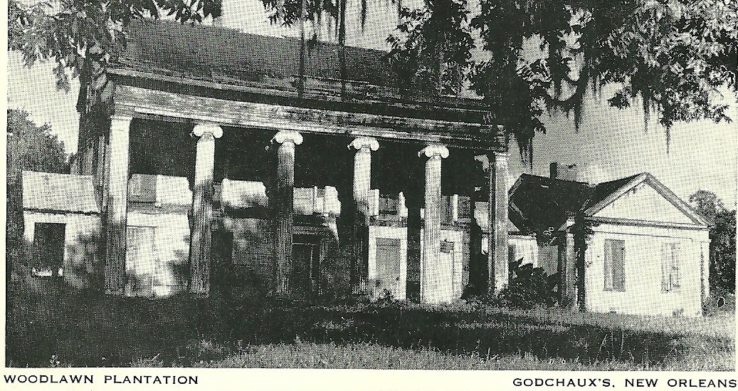 E.G. Robichaux Rd. follows the rails south or was placed on the old right of way. Manchester Manor Out Manchester I went to find the Caldwell Mill. This type engine was used throughout Sugarcane Alley. The little engine at sitting outside at Enterprise was this type.
  The spur was up behind that building. I was getting tired, remember I'd left the house at noon and had probably logged 150 miles or more at this point. Back on La.308 across from Labadieville. I bailed out just above Thibodaux. La.309 is the red flag below.
  Pictured is the Jackson St. Car bridge. The rail bridge seems to be passing beneath it.
 I first thought this was the Southern Pacific depot on the west bank, but clearly, the
business district is across the bayou. 

You are saying that this depot and the one above do not match.
I do not think that the one below is the depot. Possibly it is a freight office.
There seems to be a cattle loading chute to the right.
Speculation all.
This is the T&P east side. The rail bridge is not shown. The T&P rails seem to end here. I need help. That's when I pause and regroup. More later, Stevie Ramone. Past and Present
 Check the bend in the track on the left end of the rails. It is aligned to go beneath the car bridge right in front of that big warehouse by the water. I inverted the map to reflect the shots above. OK, more later.
 Back straight again?

