Preface note: Sometimes I ride to the point of delirium and then to complete the outing I write these recollections. Putting "delirium", "recollections" and "writing" together sometimes produces prose only I understand or understood at the time but not now. And that's fine because this is my journal, nothing more.
You are a guest here.
At US 190, just east of Port Barre, La. I turned east for a change. I was headed to Morganza Spillway Country. The word is out that the gates of the huge flood control structure on the Mississippi will be opened Thursday or possibly a decision will be made then. The crest of the Mississippi river has not arrived. I think it is due later this month. I've seen high water at Morganza and it is not quite where they would open it yet, but getting there. Mother's Day duties were done. She was grinning. It was time for a run.

I always take the railroad tour of Krotz Springs. If you know these little caches, why not check them out? You are there now. You might not be there again.
Update 2013:
The necessity of taking advantage of your time runs through this one.
I was thinking about time then and now.

There is a petroleum tank car loading facility in Krotz Springs. This is their little yard. Cars are picked up and dropped off here. Then they head up (really up as the rails are elevated) to the main line going east. What's east? Baton Rouge and its refineries, but before that is the big yard at Livonia, so any direction is possible.
. .jpg)

The rail bridge is always an awing site.
It is a historical vision that has transcended time and will probably continue to do so.

Arriving at the north side of the Livonia Yard, BINGO,
I had a treat waiting. It was the first "never saw that before" of the trip.


This is the "sawmill" mentioned by the dispatchers all the time.
It is at the north end of the yard.
Lumbering has been big here for a long time.
To the west was a large cypress mill a hundred years ago.


"Merle, I checked every engine cuz I was wantin' to wave.
There twernt nobody in them cabs, Bubba.
They wuz ROBOTS. Terminators, maybe?
The engines had "Y" behind their numbers.
Cept this one, and the "Y" might have been somewheres else?"
Gilbert, "Y" is for "Yard", you dummy.

Getting freaked out, I headed to Livonia and shot the trestle.
It's a habit practiced over time. .jpg)

Up 77, a wonderful La. highway, end to end, I went by the location of the Fordoche Depot.
I don't know why.
Trains don't stop there and it's gone.

I crossed the Fordoche crossing.

Leaving Fordoche, I topped the crossing at McKneely Spur. (below)
Seeing Mr. Louis putting his garbage cans on the road, I stopped and asked him what the story was on McKneely Spur. After 20 minutes of trying to make phone and relative connections, he hooked me up with his great uncle who told me all about the spur.
Iit curved down and went 200 yards back into the woods. It was a spur that was used for loading sugarcane and timber, very big logs which were probably cypress, probably virgin red cypress. There are still cypress trees along Fordoche Bayou. McKneely spur is also where the Texas & Pacific RR rails were realigned onto their present elevated route to the Melville rail bridge. A historian expanded that in a note to me back a while. I'll try to find it.
Locals still call the road that occupies the old T&P RR route, "The old rail-road". Farmers are factual people not given to dumb naming like community developers. Turkey Hollow? I also learned a lot of family history. The family has owned the land for over 100 years. The first thing Louis said was, "We've been here for over a hundred years and I don't know much about Kneeley Spur". I told him I'd been wondering about it for about that long. I think from that point on we were a research team. His wife thanked me for rekindling their interest in their family's history. Everyone won on that one. But, he didn't offer me a pork chop from the smoking pit. I wouldn't have either. But, he did say he would have put one on for me if I'd gotten there a little earlier. So much for my timing.

At Morganza I was saddened. There were three very cute little buildings there.
They have sunken into disrepair. The little shop on the left has lost its roof.
Morganza started this downward spiral when the cafe that was used in Easy Rider was demolished.
When I see stuff like that I have to leave or I'll start kicking cans or worse.
I've learned that cussing to yourself serves no one. You need an audience.
Just a suggestion: Don't blow yourself up with a stoke or heart attack unless you can involve other people. .jpg)

In better days:

At my lowest moment, a crane appeared to lift my spirits.

Then SHIZAM,
I found a bunch of old railroad crossing timbers. I've now seen them in Eunice, one other place, and here.
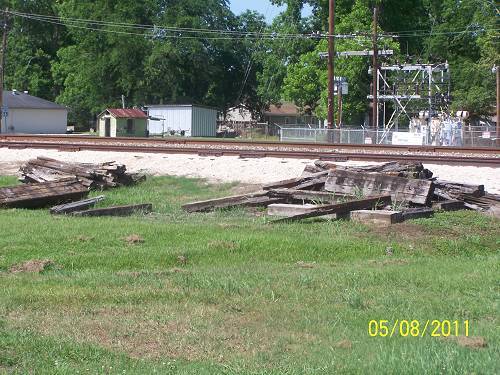
Some say this is where aliens landed (below).
In reality, I think it is where a couple of large tanks were placed.
This stretch was where the depot was. I could feel it.

It was time to check out the nearby Morganza Spillway.
Here we see the rails and the road climbing the spillway containment levee.
That levee continues south behind Mr. Louis's place and far beyond.

I'll pan a little to the left to show the rails climbing the levee.

This was just a "pond" on the river side. Views of the great expanse of water would come soon. .jpg)

I was parked.
I went to an official road crossing and shot the rails.
This is looking north across the spillway toward Simmesport.

This is looking down into Morganza.

This is looking back toward the Mississippi side for no reason.
Maybe I was trying to compare the Mississippi side water level to the yet to be flooded south side.

From there I walked back across La.1 to my bike.
An official in an official truck was eying it.
I had timed my trip well. After the gates were opened you could not get near this place.
The "authorities" were rightfully afraid of treachery.

I joined the rubbernecking Sunday drivers. Let me ask, when you rubberneck do you steer toward where you are looking or the other way? I go the other way, I guess to avoid hitting what I'm looking at.
In motorcycling, I've been told that you go to where you are looking?
I think I've discovered a hitch in that theory. .jpg)

At the north containment levee I parked at a familiar place.
This is the ramp I used to go down and ride old La. Hwy. 1 which lies on the Mississippi River
side of the control structure.

In dryer days this is La.1. The road was raised in 1958. It does resemble the Great Wall of China.

This is the structure.
This shot is next to impossible now because of construction there.
It was taken from the Corps' shop area south of the spillway off La.1. I'm thinking that there are 125 gates. Don't quote me.

Turning east on 419 at LaCour Spur, this is an old oil burning engine used in a cotton gin.
A person came by and told Al and I about it.
Then, mysteriously, he left. I'm not trying to run that Time thing in the ground,
but he sure looked like Professor Einstein.
I took the road toward the river, on the dry side.
Not every tourist rubbernecker that twas out and about knows this spot.
At this point let me tell you potential levee riders, the heat is out and they are patrolling.
With heightened security in such demand, I was glad to see them.
The next time through the National Guard would not let me take any pictures.


This is looking southeast to northwest.
Morganza would be at center top of this page.
The Mississippi would be over my left shoulder.
This shot reminded me of pictures of the 1927 Flood. .jpg)

I was digging the egrets. Funny animals. Pretty dumb, but funny.
I think this is a dredge. I have no idea what it was digging.
That is a road below, not a boat launch.


More shots. I am wondering if the Corps worries that if they open the gates the water will come.
To the naked eye that doesn't seem an immediate problem. Maybe it was carting around those back hoes.

Variation on the same theme.

This place doesn't change.
I was riding a Guzzi in 2001 when a shot identical to this one was taken.
The bales of hay may have been in the same place frozen in Time.

La.419 to Claiborne Road to La.418 follows the levee.
There is no better way from Morganza to Simmesport.
The amount of history along this stretch is phenomenal.
The Civil War is commemorated at St.Stephens and
General Banks occupied Simm's home.
This is the home of a famous WWII flyer.
It goes on and on.
Plus, this is area includes the Torras Peninsula.
Not interested in history?
The levee road is beautiful.
This place may have inspired my handle, "Levee Rider".

Old River Landing was sunk yet again.

Houseboats were the only structures above water. I didn't see the famous raised trailers. .jpg)

If you see water, it's on the east side where the Mississippi still is.
This is the road where I found remnants of the first route the T&P took to Torras.
It was moved when the river took the town of Red River Landing.
Check out the Lejuene Family writeup for an intense explanation.
The two Torras writes do also.

This feeder is sitting on the old Texas and Pacific RR rail bed.
That's a fact.


When I was told about the original route, it sure brought a grin.
Traces are on my old Garmin Topo software, a priceless addition to this hobby.

Below is what I'm talking about. "TP5" marks the above location. (bottom of the map) You can see the brown dash lines heading toward Red River Landing, now submerged. I have a picture of RRL. The train went through it on the way to Torras The red line is my track. Click the map. Further Info, Torras Landing was where Edenborn's trains left for Angola, not at Angola landing as the uninformed have reported.
Wheat was everywhere. Mr. Lewis said they were getting theirs in before the water came up. He also said that the water would probably be down in six weeks and that he wasn't worried about planting the beans.

More water and road level comparisons.

The birds were "good" with it all.

At Angola Pen landing, it seems that the ferry was probably not running, so visitors had to take a boat across to the prison. I did not investigate thoroughly. You do understand, I hope. .jpg)

I took La.15 up to the locks. Out there were the bridge supports the T&P RR had used when it left Torras and headed north to Ferriday. This is why the railroad gave up on the line. Submarine trains were not invented yet. Will they come in time? {At this point, I think delirium was taking over}


I scanned the water and only saw this one thing peeking through.
It may have been part of one of the supports.

La.418 is on the right. This is a serious situation. Now, why are there trees on the left?
Could the land on the left be higher also?
Yes. All that silt that was suppose to be building Louisiana is just filling her up
and causing floods to be worse. The Corps boo booed.

Heading toward La. 1, this cute little house sat next to the road.
It had hree front doors.
Doors were an important part of the interior's environmental control system.
Not much has changed over time.


At Simmesport, on the Atchafalaya, I took a bunch of shots. La.1 Bridge

Edenborn's LR&N Co. Bridge (1928 approx) He died before seeing it completed.
I reflect on some of my projects. Oh, well, that's timing.
Update: I never appreciated the shot below. I guess "all things in time".

This is the swing section. I bet it's a great place to work. Thunderstorms come to mind. .jpg)

A peek at La 1.
This was a scary place to get.
It is near where the old fish plant was. I suspect this location has been used for 100 year.

The river is not happy. In fact it's boiling.

Both bridges.

Evening shot:

Ok, here's the next "never saw that before", harvesting wheat in Louisiana.
I was transported to North Dakota. No, wrong, there are trees behind the field.

Down La.105, the Atchafalaya Road,
I flew to Bayou Current, then across the Bayou Rouge basin to Palmetto.
It's got a great old feed store/mill of some kind next to the tracks with its old abandoned rail siding. .jpg)
.jpg)
.jpg)


Here's looking at the depot location with the mill in the background.

Back in Port Barre, I took a picture of a barn I'd shot in 2001.
I was back to where I started. Tick Tock The clock goes round.
I shot this old barn back in 2002. It has aged.


I'd never shot the old Port Barre bank. Too many people were always around.
Now it seems like a place where garbage is kept.
That made me reflect on those in charge of our Treasury and Federal Reserve Bank.
Wait until all their play money hits the streets.
In time I hope we can get that thief out of our lives.
That's it.