The NOL&A passenger railroad, or Nola, as it is sometimes called, runs from Gretna, across from New Orleans, up to Livonia and then more or less follows US 71 into Alexandria. I recently had a chance to take the ride from Big G on up to Alex. Early on I lost my camera, what a klutz. Wait just a moment while my blood pressure subsides a bit. Thanks, I think I can carry on. I'm going to try to replicate the ride with a batch of older pictures. Though not as interesting as the trip, they will be a taste of what my camera might have caught as we were able to get off the train and walk around a bit in each of the whistle stop communities.


Below you can see the Jackson Ave. Gretna Ferry, and
3rd Street, where the depot is located. There is plenty
of parking.

Zooming out, the many rails that make up theNew Orleans
and West Bank waterfronts come into sight. For some reason
I highlighted the West Bank rails. That was pretty messy.
We'll be headed west.

Gretna: Click Here
Gretna Tour movie short: Click Here
Algiers Point: Click Here
Algiers Ferry: Click Here
The map below is large. Click it to see. We are moving
from right to left. Bet you thought the river ran north
and south.

Soon, we went under the rail approach for the river crossing
Huey P. Long Bridge.

During this visit I couldn't believe my luck.

Next was Avondale Yard.
The plaque appears to say "West Bridge". I would assume
the name refers to the west entrance to the Huey P. bridge.
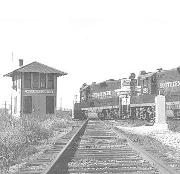
The little house on the west end of the Huey P. Long
rail ramp is now somewhat diminished. I expected
to be yelled at from its window.

I accidentally found Avondale on my last ride over there.
It was in preparation for the writing of my big Southern
Pacific production following the rails from the West Bank
to Lafayette and beyond. I submitted it in chapters and
never got any feedback or guest book entries so I quit
at Morgan City figuring the hard work made no sense.
This yard was next after my exciting visit to the bridge.
I had no idea I'd be able to ride right up to the landing.
Beyond there was this.


The next stop will be Luling. Al said he'd be waiting there
but wasn't. Maybe he said that he'd be waiting at Lulu's.
Luling in in the middle of industrial south Louisiana. Petro-
chemical plants line the river. The Luling Ferry Disaster
is the worst ever to happen in the US.
Let's move on.

Next up the line are the towns of Edgard, Wallace, Vacherie,
Lagan, the big town of Donaldsonville, the town I hear
mentioned on the scanner all the time, McCall, Noel,
White Castle, Tally Ho, Allemania, Seymourville and
Plaquemine, which means "persimmon" in French.
Ok, "Allemania" was named by the German settlers,
just like Des Allemands which you can visit in the SP
writeup.
For those that don't know, this area was dense in plantations
and money from the beginning. I just found a 1914
book which mentions an electric railway between Lockport,
Thibodaux, and Donaldsonville. This from the "Electric
Railway Journal". Money equals towns which needed
transportation and they could afford the technology.
I don't know if the railway ever materialized.

This is another tidbit I found. The T&P had a line
that ran down the bayou and crossed at Napoleonville
and came down the east side to Thibodaux. This
was its beginnings. From the "Railway Age", 1900.

Sorry, I had to skip over this area because I don't have
any pictures of it. I can remember large amounts of
sugarcane and back swamp.
A side note: The Burger King in Donaldsonville is not
recommended.
The the train entered Plaquemine running down the center
of town (historically).

It runs right down the avenue. I love this common set up.
New Iberia uses the same. In fact, the curbs on the rail
side seem similar.

The crossing signal as seen on main street.
Look close.
Look close.

Here's the old depot. Notice the opening about 2/3's way
down and the bay windowed area half way down. I
don't know if the large building behind it is still there.

And how it is today. This is the street side.

This is the rail side. It is a furniture store now.


An old luggage / freight wagon sits in the walkway.

The bridge over the bayou is the most interesting piece
of architecture in town, at least what I've seen.


Leaving town, the rails (two tracks) are extremely busy.
To the north is a very busy junction and yard.


Welcome to Addis. Here there is a large yard and junction.
One set of rails runs up to Baton Rouge and then to
Alexandria basically following La.1. The other route
is the more interesting, the one we are on. It crosses the
Port Allen Canal on the Morley Bridge, another
impressive one and then a large swamp before getting to
Grosse Tete. Then it takes a very scenic route up to
Livonia passing through the picturesque town of Maringouin,
pronounced just like it looks. Next is Livonia and its huge
yard. The rails cross the old Missouri Pacific line that
comes from Baton Rouge and headed west following US 190.
Heading north our ride gets interesting as swamp and another
large river are crossed before settling into its run up
US 71 into "Alex".


More of Addis at the old bank. Wonder where they found
that caboose?

This shot reminds me to remind you, don't come here at
night and be aware that these trains are moving very
quickly. A good site to get that sort of info is HERE.


That's it, I'm out of steam. Actually, I was out of steam
halfway down the page and coasted to here. More later,
if I get stoked. Thank goodness the Nola has a napping car.
Until then, check out Plaquemine and Back.