Port BarreThe other day I sat in 100 degree plus temps to take a picture of a train crossing the Little Teche Bayou. The place was between Opelousas and Port Barre, La. In all my previous life I never suspected that I'd become in the least interested in Port Barre. But, Port Barre is interesting. Its main claim to fame today is that it's the "Birth Place" of Bayou Teche. PB should ignore that claim because the source is not a very pretty place and, well, don't waste your time. What is prettier is the main bayou, Courteableau. It was a very important artery to western expansion back in the day. But, that's outside of the scope of this write. Port Barre should have a transportation museum. It courted four or five railroads at one time. Before that were the steamboats, stagecoaches and covered wagons. This place goes back to 1720. There's been a speed trap there ever since.
I got to know Port Barre back when I was following the Southern Pacific Railroad from Cade to Port Barre and while Mark and I were tracing the OGNE through there, both are GONE, now. The only railroad through town is the Union Pacific which bought out the Missouri Pacific which had bought out ...
The rest just faded away after one buy out or another.
Railroads and Port Barre have been mates for a long time. Here are few pictures I found after Shane sent me one that was for sale on EBAY. Turns out the picture the guy was selling can be had at the Library of Congress, free. Each of the shots below can be clicked to make larger, then hit your back arrow to return.
1938 Section Crew (hope I have the term right)

Could that be the Section Boss's house? Most are wearing
goggles. I would suppose to keep the cinders out of their eyes.
1913 Grass burner.
Looks dangerous to me.

All of these were taken at Port Barre, I suspect at what
is now the UP yard behind Dixie Storage where the
MP depot was located on Frisco Street. You can see
"Port Barre" on the building behind the burner.
This is Al and Mark in another life, 1938.

Filler up at Port Barre.

Check out these pages for more about
the railroads in Port Barre. CLICK HERE
to go there. It was the 3rd time I'd sworn
off railroad writes. There have been 47
more, each time a swearing occasion.
More later.
The MP: Cecelia to Port Barre, La.Saturday was evaporating into more humidity. Summer was here. It would not retreat again as it has, thrown back by an enduring Spring. Now her time was gone. I moped around like an abandoned child left at the station as the train pulled away, two lights on behind (Rolling Stones). Could I leave the dogs for a few hours? Did I really want to go? Maybe I'd take a nap. Maybe I'll take a nap, now.
Stop that, get back to work.
OK.
The process of preparation commenced. At least I'd be ready if I decided to go. Food, water, camera, oil, a light t-shirt, sun screen, helmet, rain coat, leave, go one mile, and ride back because I didn't have the GPS. I almost continued without it, but, I know better. I would not be writing this if I'd blown it off. It is the only thing that sustains my interest in local riding. Without it, I'd just park the bikes, believing I'd seen it all. It is my microscope and my telescope. It suggest points of interest it doesn't even realize its doing. That is what it did today, saving an early return with nothing gained.
I finally broke lose from preparation hell. Again I was headed up the same old route out of Sub-190 Louisiana. I melded with the dull haze of the silver sky. No matter, I knew I was doing the right thing as sitting at home is terminal. I just didn't have any enthusiasm. Then I noticed my route was following the old rail line, long gone and disappearing quickly. I would investigate and photograph every bit of evidence I could in the short stretch north to US 190, the location of the existing main line. I was already above Cecelia so I had missed some of the bed north from I-10, but not much, and it would be easy to catch it later as that is my neighborhood. At least I had a mission and a game, a well worn game.
I don't expect you to be interested in this report or the pictures or my bizarre attraction to invisible trains or rails. If you decide it's a good time to go bathe Fideaux, that's fine with me. You can go your own way, (Fleetwood Mac, urg) Come along if you want. Here's a big old map of the first section of track tracking. It gets big if you click it. The yellow line is me. The purple line is the tracks, or close.

Viewing the following pictures of humps in the road, bare places in the fields, weeds, trash trees and broken down houses, remember, they are only a bit of what is to be seen down yet another Louisiana yellow brick road (Wizard of Oz). Ray, the beds passed no churches. Gotcha, yes they did! But, you'll have to wait until Part 2. I don't want to lead you on, LIKE YOU HAVE ME. Mobile Zoo, bad.
I'm not going to tell you, "this is the rail bed at Beknell Road", unless I find that bump or hump or dark tunnel extremely interesting. Here's A bunch of pictures:
One day some jerk running for Parish President will put into his platform a promise to level all humps, an equivalency to burning books.
.jpg)
First, I snap the hump and then I try to shoot from its apex up and down the line. Some humps only got one shot as shooting a mass of green tangle doesn't say much. Try to think of the humps as Indian Mounds. All right. Are you with me that far? No, go back to where you were.
.jpg)
.jpg)
The rails now bordered a wheat field. I bet they weren't ready for that.
Steve Miller
.jpg)
Some guy was using the old bed as his dive way. This is all taking place between Cecelia and Arnaudville. Here are the names of the communities that were visited by the tracks between I-10 and 190. Two are just south of I-10, but I'll include them anyway. This is going north. Right click that map and choose "open in new window" or something so you can follow along. If you want to sing along, use Johnny Cash's "I've Been Everywhere" for the music part.
Patin
Champagne
Cecelia, also known in the old days as Grand Point
Huron, Huron?
Bushville, I wonder if Tina Turner lived there?
Darby
Arnaudville
Robin
Pecaniere
and Chiasson, our first landlord.
Back to the pictures.
Here's just one worthless picture to give you an idea. I won't do that again.
I promise.
.jpg)
Now the peripheral looking beyond shots.
.jpg)
Well, pickins were slim.
.jpg)
Here's a picture with a message. (Canned Heat)
Telephone lines follow railroads. Telegraph line did.
.jpg)
Arriving in Arnaudville, the hump is on 347 going into town. Look at the creosote planks. Had there been a bridge here or a station or platform of some sort?
.jpg)
I followed the bed into Arnaudville. The train ran between the trees. I'm not saying the trees were there. I think they've been planted since the bed was abandoned.
.jpg)
North of town, a peripheral appeared.
.jpg)
Back on track, better move, I hear that train a comin'. (JC again).
.jpg)
Sorry, I'll make it up to you (Dick and Dee Dee?) Here's a bunch.
.jpg)
.jpg)
.jpg)
Now we're getting into the Pecaniere area.
.jpg)
.jpg)
Here's the old school house in Pecaniere. It's a pretty nice home, now.
.jpg)
If there had been a station in Peaniere, it would have been here.
.jpg)
Almost to La.471, there's another hump just before the highway.
.jpg)
The next shot is along 741 between Pecaniere and 190.
.jpg)
I could see where the wye had been connecting this line to the main at 190. I turned toward Opelousas and then crossed back over and pulled over. I was going to jump the ditch to see if anything remained of the connection. Then, duh, a train came along. I couldn't have anyway, the ditch was full of water and way too big. I had to give up on that one. It hurt. Below is how it was set up. Remember, I'm yellow, the old bed is purple and I was on La.741.

That's it for tonight. Opelousas to Cheneyville tomorrow. It will have some surprises. Have you ever wondered why there is no train station in historic Washington, Louisiana?
And, yes, the Saturday doldrums were gone. I was on a roll. If Indiana Jones could pull it together another time, I knew I could.
The Oaklawn BridgeCLICK TO EXPAND ALL PICTURES
I needed to get to Oaklawn on Irish Bend.
I headed down through eastern New Iberia thinking what a breeze this was going to be.
More on the breeze later.
As soon as I thought how easy it was going to be, two of my required roads were closed for construction or something. I jumped on old US 90, now 182, and made my way using the back road, La.87, in places to avoid towns. I wanted to trace the railroad from Adeline to where Mike's uncle had tended the bridge at Oaklawn. I knew that there wasn't much evidence left, but I'm the eternal optimist until proven wrong. This time I just wasn't smart enough as I had to deal with people and my interrogation skills are not practiced.
From that I guess you know that this will not be a report on a victorious find, but one of a dern good try only wanting in the negotiating field. No, it was a failure.
Be warned, this will probably only appeal to the grass people, ie, those that can see old rail beds going through fields where there are none. To help the more sane, I now have a red marker. I love it.
This page will have one good picture, that of the bayou. I promise.
I'll make it fast to lessen your pain. Here's the map again so you can see the rails that start on the west at Adeline, then go to Charenton where they cross Bayou Teche, traverse the swamp below Grand Lake, hit Oaklawn (present residence of X Govenernor Mike Foster), recross the Teche, where Mike's uncle lived and tended the bridge and then head back to the main line at Franklin. My theory is that the line serviced the sugarcane plantations there. In fact, I saw a spur running to one.

At Charenton, I had to shoot down the long backyard of a private home for this picture of the swing bridge turntable support. Yes, I know, it's just a hunk of cement in the bayou. But it has a story. A locomotive failed to stop when the bridge was opened and went into the bayou. According to Jacques, it was retrieved, a miracle it seems to me.
This one is from the road:
.jpg)
This one is from the Teche Bridge:
.jpg)
I found Jacques' priceless story about the engine that went into the bayou.
Concerning my question about the old railroad tracks that crossed Irish Bend from Franklin and continued across the Teche to recross the Teche at Charenton and return to the main line, Jacques'reply was this. "The only thing that I think is still there is a hump in the road about a half mile from Medrick Martin's store, heading towards Adeline. That must be where the track crossed. It's been a long time since I was in the bayou in Charenton but I think the approaches for the rail bridge and maybe the foundation for the turntable in the bayou are still there. When I was in school in the early or mid seventies an engine went into the bayou at that bridge. The bridge was open. Papa told me he had heard that the engineer had been drinking. A classmate who lived near the M.P. & S.P. tracks in Jeanerette told me that he saw what must have been that engine being pulled through town by another engine. He said that it sounded like something was dragging and hitting the cross ties as the engines passed and that the engine was covered in mud. I didn't believe him since he used to like to spin a few tales pretty often. A little later on we were walking along the track and we saw that on every cross tie there was a big fresh gouge almost in the center of the ties. My friend said, "That's where that thing that was hanging from the bottom of that engine must have been hitting". We looked at each other and started running down the track to see where the gouges ended. After a while, not seeing an end to the marks on the crossties we stopped running, all out of breath and sat down and started laughing. I told him that I believed him...now. We walked back to town and got a pop at Miss Lu Lu's store right by the track and sat on the store steps and watched another train go by".
Next, I'd ride into Baldwin and cross the canal on the high US 90 bridge. I think that bridge is in the old movie, "Easy Rider".
We have a tropical storm off the coast and the breeze was picking up. I would be batted around a bunch from this point on. I opted not to cross that bridge on the way home. Learned options served me well on this ride.
After the bridge, it is a short ways to Irish Bend Road. That is where I saw the spur to the plantation immediately on the left as you begin the road. There is an old store that I should have shot once again but I was in a feeding frenzy to see the uncle's place.
I passed Foster's place, Oaklawn Manor, and then looked for the bump.
.jpg)
On top of the hump, I shot toward the bayou in hopes of catching some evidence. Why didn't I zoom in? I guess I was nervous about sitting in the middle of the road? Blunder One, Blunder On. Here's what I supposed was the target.
.jpg)
I should have shot inline with the power poles. That would make sense once on the other side. Power lines occupy right of ways, often the same as the rails had.
I went back to the bridge and crossed over.
.jpg)
I took a shot in the opposite direction of the old train bridge. This is the good shot. From here on it's all down hill.
.jpg)
I was now on La.87 where it turns to gravel.
.jpg)
The GPS told me where the rails were. I shot down the right of way, appropriately supporting a power line, a sure sign.
.jpg)
Of course, they are the same lines that are on the other side.
.jpg)
After careful inspection, I think I see a roof line and something shinny.

I hadn't seen that from the road. I'd given up and went to look for a land owner. There was a farm shop at the intersection and I mozied in. The young fella said there was no old house back there and nothing in the water but, maybe a few old "sticks". And I accepted that and left. I'm loosing it. I should have simply asked to walk back there. Period. Instead, I gave him a menu of stuff to deny. He'd never looked for the old bridge and the house was located next to the water away from his plowing area. He was leasing the property, he had no family connection to the land. I am berserk with my failure. You've never seen me mad like I get with myself.
I went back to the bridge to see if I could get a long shot to the shore where the line had cut through the woods along the bayou. I did. It was 9:30 sun time. The light was shining from the east, (left) down the cut that the line had made into the water.
.jpg)
I knew I'd lost it but didn't want to bother the guy again. I'd rather check it out in the winter anyway, I rationalize.
Heading home, I found where the old train yard had been. Yes there was still a bit of evidence. Red marker!!
.jpg)
And this:
.jpg)
I was back opposite Charenton hoping for a shot at the old bridge turntable from a closer vantage. No, there was none, but I did see where the tracks crossed 87 headed across the Teche.
Not all was lost, I am now going to draw on all my pictures with my new toy.
.jpg)
Yes, I will return, this one is not over yet.
The Sugarcane RRThis one will be about tracing the Sugarcane Railroad from Loreuville to New Iberia. To orient those who care, the line progresses north to US190 at Port Barre. The section above I-10 has been covered. The stretch north is still visible on the back roads and fresh in local memory, including mine, what a surprise. This one covers the ripped rail bed in Loreauville and its route across the big bend of the Teche to New Iberia. Next, I followed the existing rails which were a part of the original route into NI and out of NI toward Abbeville. That's where things got manic. It was like the first time I'd gone bowling.
The ride and report will be and was of a nonchalant nature until the manic part. The first pictures are not quite up to Grand Canyon standards but work for the mission. Actually, there was no mission. I was at home and it was 2:30. In a last ditch effort to ward off insanity, I hopped on the bike and aimed it south. I had the urge to sit on the end of the world at Cypremort Point for some reason. The place is not the same anymore and every time I go there it disappoints. Being diverted from CP was not a problem. I guess the last time I really had a good time there was when I was at the bar and the Apollo whatever had just landed on the moon. One fella said it had landed in Hollywood. I said it was Arizona, another thought it was New Mexico, then I agreed with him.
I bypassed Loreauville on its back side. Somewhere along that route I remembered the bump I'd found in town, or sorta out of town, it matters not here as I'd like to keep this as nonchalant as long as possible. I just hope I can contain myself long enough to show and explain the heavy archeological finds of the first half of the ride.
Here's a map. It is a big one. Right click it, choose "open in new Window" with a left click. If that's not right, reverse the directions. There you can see the bend of the Teche, the numbered shots which will be nonchalantly presented, possibly incorrectly, and also featuring the spot where the depot was and the cistern, which is what Mr.Breaux called the elevated tank which was used to fill the steam engines. Yes, I opened a library when I interrupted Mr.Breaux as he was mowing his yard. If you want to learn stuff, look for white hair.

Back to the ride. I was on the backside of Loreuville thinking about the bump. I know, my ride criteria has gotten pretty personal, and to some, twisted. Nevertheless, I will continue to share it. I was without the GPS so I couldn't see the old line. I was going to have to think on this one. I had met a fella on a previous ride who lived near the VIDA bridge on the other side. He had said the bump near his house was indeed the railroad's. So I knew the rails had come south through town and crossed La.86 and then the Teche and gone off into the sugarcane fields toward New Iberia. My first mission was to find the bump in La. 86. Sure nuff. I've crossed it a million times and never thought about it. You?
Actually, you and I haven't noticed because the bump is gone. It's more of a slight rise in the road. If you stop at its apex you can see the bed both ways, what gorgeous sights. Chilling.

Here's from the other side.

I progressed northward toward town, taking these shots at each bump.


Then I turned at the high school. The phantom rails ran right behind it. Actually they ran into the football stadium parking lot. The football team all stopped practicing to see what that fool on the bike was doing. I had visions of being a tackle dummy. I could hear Coach Dupre' yell, "Get him". They'd call Sheriff Touchet and he'd call Homeland Security. And none of them would be wrong for doing it. We haven't met, have we?


I returned back to where I'd started, at the La.86 bump and looked for a road to take to get a shot of where the rails had crossed the Teche. I stopped where this fella was working on his car and asked if he knew. I also asked if he knew where the old depot had been. Sure he did, just go down Railroad Street. I guess I'm no Indiana Jones. Unfortunately, he had nothing to offer besides trespassing to get me to the crossing. I declined, thanked him and went looking for the first stop light, duh, La.86 and Railroad St.


That's where I interrupted Mr. Breaux while he was mowing. Our conversation was textbook Cajun etiquette. I introduced myself and apologized for the interruption asking if he could answer a question for me. He said, sure. I asked him about the depot and if it had been removed or torn down. He said it had been torn down and that it was the size of a small house. The depot was made up of two parts, a sitting area with a ticket window and a baggage area. He told me that it had that cistern for servicing the steamers. He went on to say that the circus would come to town on the train and there would be touring exhibits. That map shows a siding where these cars could park. He also said that most passenger traffic went to New Iberia where a transfer could be made, and that the line went north to Port Barre, also. He added that there was a spur to the Caroline Plantation toward Lake Dauterive. I forgot to ask him if there was a mill at Caroline or did the train just pick up the cane there and how did it turn around? I'm amazed I remember that much. Anyway, to continue.
Next, he had questions. The usual, where do you live, what is your name. Luckily, I live next to a landmark which everyone knows and I can convey my location simply and exactly. My wife also taught locally and is "famous". Yes, she has gray haired ex students and all of their parents know her. I am simply known as her husband, originally known as her husband with the horse hair until I cut it off. I knew some of the names of his relatives and relatives by marriage, his wife being from Parks. I sure hope I can catch him again. He was a delightful person and a true library of local knowledge. That was the true high point of the ride. I heard him say as I left, "Now I have to cut the rest of this grass". I think Mr.Breaux was about 75, pushing his yard in the mid afternoon heat and humidity, looking as fresh and neat as a cucumber on ice in his pressed white shirt. I was sitting of a bike, sweating in a nasty Walmart t-shirt. Got the picture? Some have class, some don't.
I rode on down Railroad Street to the elementary school. Its back parking lot is where the station was. This is not a good picture. It was taken from the parking lot looking north. I should have included the parking lot. Oh well. Imagine a parking lot.
.jpg)
I rode back up Railroad which then crosses the red light on 86, Main Street, then crosses the Teche Bridge. I was ready to attack the big bend area in search of the rail's route to New Iberia.

I parked and walked back out onto the Teche Bridge. I zoomed down the bayou to see if I could catch a glimpse of where the turn bridge which Mr.Breaux had told me about had been. There was some concrete down there but I doubt that was the place. My camera is 10x and it does reach out.
.jpg)
.jpg)
.jpg)
.jpg)
After taking these shots I hopped on the bike and headed for the bump near the Vida Bridge. I was told these cement blocks were used for a water tank at the bridge.

I was at the old threatened bridge. You can't have to many bridge pictures so she got shot again. This time, I'll show you a prize which backs that last statement. It is of the Vida Bridge in working order doing her job.
.jpg)
This bridge, unlike the ones at Ruth and St.John, did not carry train traffic.
.jpg)
Looking up the river from as far out as I could get on the bridge approach, no sign of the RR bridge was seen. I'm sure it was completely removed.
.jpg)
Wait, look at the photo again. Just before that indention on the far shore, there is some gravel next to the water. Gravel is not common on our bayou shores.
Here's the map before I forget. We are at the bridge near where it says BUMP.
Next, I headed west out Vida Shaw.

This is where the line crossed Vida Shaw.
.jpg)
I crossed what I though were other bumps, rail crossings. This was a huge plantation with a mill very close by. Could there have been rails to the fields?
The road passed some very nice homes. I saw this cart in the front yard. I immediately thought it might be from the depot. Carts, similar to this, were used to carry baggage and pieces of freight. Yes, they had flat steel wheels.
.jpg)
Here's the nearby mill. I don't know how old it is. We'll see an older one soon.
.jpg)
This is the La.677 crossing. I tried shooting back toward the sugar mill to see if there was a siding to the mill. The shot failed. I'd gone over into digital zoom and it's trash. I am guessing the old line is used to service the mill and then stops. I need to check out the Sugar Oaks crossing, or maybe I did?
.jpg)
I thought I'd turned off of Daspit onto what is still called 677. There were sidings there. I was getting into track wonderland. I was getting bowling pumped.
.jpg)
Here's a look at all those tracks and what is to be seen next.

Here's the old mill, marked as "refinery" on the map.
.jpg)
And the siding that went to it.
.jpg)
I followed 667 to La.31, a very familiar old area.
More of the Sugarcane Railroad.
Here's a map update.

See La.31? Daspit Road brought me there. La.31 coming in from St.Martinville has classic 1950's steel buildings and other old architecture along its route. That was the era I came to south Louisiana and was introduced to this architecture.
But first, these are the crossings on 31, then the buildings.
Here's our main line:
.jpg)
And more tracks in the maze.
.jpg)
Now the neat steel warehouse. These were common all over south La. A twin was in Houma on Bayou Black near the golf club, I think.
.jpg)
Here's a very old warehouse that is being renovated. This is on Jane Street going south. Jane (La.31) curves to the southwest and crosses Main where I turned north toward Lafayette trying to pick up the tracks again.
.jpg)
Which I did. I stopped on Main, La.182 and shot this looking back east .
.jpg)
And this, west.
.jpg)
I followed that road until it left the tracks. Then, not to lose them, I crossed a vacant lot and did a hill climb up to another street. I was at The Junction. Junctions, confluences, they are all very powerful places. I got railroad overload and took 50 shots. Here are some.
Here's our ine coming in from Loreauville. Pretty, huh?
.jpg)
Here's the SRR entering the mainline. What was that concrete structure?
.jpg)
Here's another view of the approach.
.jpg)
This is terrible. Here I was at a magical moment in time and space and I blew the picture. I should have gotten the switch and the whole deal from the other side. You can just see a little of the approaching SRR across the rails.
.jpg)
If you think this page was exciting, you have not seen anything yet.
It gets animated.
From the junction I headed to the station. I'd been there before but it was at the end of a ride and I was whipped and not really into absorbing my environment. Whipped or not, if I had seen what I saw this time, I would have been a bit more absorbing. OK, I'll start with the depot. First, the depot was in pretty good shape but the area around it was overgrown and pretty unkempt looking.
.jpg)
This is the backside, or the side the passengers would see. At least it had a good roof. At least it was still there.
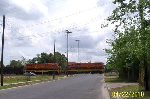
Moored in engine only parking were these behemoths.
It was like I'd sneaked up on a heard of elephants on the Serengeti. Quiet!
.jpg)
.jpg)
.jpg)
.jpg)
I jumped the tracks and got this picture. The little building must have been for the scales. Just guessing as usual. It's hard for me to rise above being nonchalant.
.jpg)
While over there, I saw these rails headed off to the west. Of course I'd follow them.
.jpg)
I decided not to goof off and check the front of the depot for a parting shot.
.jpg)
.jpg)
Ah, the depot is now the office of, or a office of the Louisiana and Delta Railroad which explains no municipal upkeep. It doesn't explain little corporate upkeep. OK, money is tight, fuel is high and it's rained a lot and engineers don't mow grass.
Nearby this grand old house stands, and look at the brick street. Was it a hotel in the grand old days?
.jpg)
Back across the tracks I went to follow the westward running rails. I stopped for this great shot of the depot. Mother Nature lent a hand in mellowing the scene.
.jpg)
I followed the tracks west paralleling La.14. I can see it was headed for Abbeville and Avery Island, home of Tobasso and so much more. These pictures were taken in New Iberia. I hadn't gotten to Admiral Doyle yet.
.jpg)
Then this mundane shot:
.jpg)
What was that down the line?
.jpg)
This would demand extending the ride. It was approaching 4:30, no matter. When it comes to eating on time, I'm very nonchalant. I also lie.
The street I was following, that was following the railroad, turned, but not before offering this nice shot. There was a guy sitting in this yard giving me the stare. I don't blame him. I'm sure he's no different than Coach Dupre', Sheriff Theriot or Homeland Security.
.jpg)
The place off in the distance on the rails was a shop.
The pictures that follow will have to do. I felt I was in a toy store and wanted all of them. There was no big gate or enclosure to block most of them. I rode the bike right next up close, and if I'd had the nerve, I could have touched them, probably setting off some alarm. I will admit that when I was 11, Kim and I tried to take a diesel from a lumber yard. Thankfully the watchman caught us before we could find the keys. I wasn't going to draw the watchman again.
.jpg)
.jpg)
.jpg)
.jpg)
.jpg)
.jpg)
.jpg)
.jpg)
I had found the Holly Grail or back to the bowling analogy, I'd just rolled a 300.
I could go home now, breathlessly satisfied.
But, it wasn't over yet.
I was stopped by nothing less than a train.
.jpg)
The crossing was just before Old 90 or La.182.
As soon as the gate cleared I swung left and chased the light fast moving freight down. I needed more engine pictures. I think I was infected with the same thing those train nutz get. I collected stamps at one time and experienced a little of that mania. But this was different. This was big boy stuff, pictures of real engines. No game there.
This next picture is the animated one. I took it on the fly moving with the freight at over 50 mph. Pretty awesome.
.jpg)
I caught the freight because it had stopped in Cade. I pulled into some business across the tracks and leisurely took my shots in a relaxed professional manner. No, I fumbled the camera in that goofy fetish I was experiencing.
.jpg)
.jpg)
.jpg)
.jpg)
.jpg)
Here's the kicker, all of these engines can be found on the internet. They are all cataloged and the history of each is documented. Yes, there is a following. I don't get it, but different strokes for different folks. Heaven help me if I ever get interested in freight cars. Those are cataloged and memorialized, also.
Now I was tired. I knew a place to relax if I could avoid the alligators. I couldn't go home. My wife would have pulled out the blood pressure cup and wondered what was going on.
.jpg)
.jpg)
.jpg)
Later gators.
PS: There is no Sugarcane Railroad to my knowledge.
The line through Loreauville was the Missouri Pacific and before
that the Iberia and Northern, or something close to that.
Snowballing to AlbaniaOne of the pure pleasures I've had doing the website is creating connections. I've even hooked up cousins. It is South Louisiana, after all. Information connections have been especially rewarding. In other words, I, or someone who writes in, will mention something that then jars another person to think of something and then that is added. These additions snow ball into a larger and larger collection of information. That's what this site is all about, scavenging everything I can before it is gone. Everyone is a library. When a person is gone, a library closes. That's a quote from another contributor, years ago, and so true.
Jacques wrote saying that he had enjoyed Mike's write on the railroad shanties. This is from Jacques' note.
Thanks again, Steve. This guy's got a real talent! I've enjoyed this one the best, so far.
It makes me think of things Papa told me, like when he pointed out a couple of fellows from town who he said were on the, "section gang" a long time ago. After asking Papa a lot of questions he'd proceed to tell me about the section gang, who he knew, or used to know, who worked in it, where their quarters were and about hearing the songs and the sounds they'd make to keep the work in time, along the track in town all the way to Albania where the water tank and hobo jungle was.
ME:
See, "makes me think of things". That's the way it works.
Reading Jacques' recollection left me with only one alternative, especially since he closed the note with, "Your assignment is to get some pictures".
I was off to do the "track in town all the way to Albania". Words like that are irresistible. See the snowball getting larger? You will.
Snowballing to Albania
I rolled out to the end of my driveway just in time to see a tractor lumbering down 347 pulling 2 carts of sugarcane and 37 cars bound for the St.John mill. I did not want to couple on. I turned north and then cut over to a back road that takes me to Parks where I hooked up with Section 28 Rd. (haunted). Section 28 takes you to La.96. At the old Missouri Pacific bump in the road, I saw this house which was very close to where the old rails had been. I know it's "reaching", but that place sure doesn't look like a home. You know I imagine old railroad stuff being everywhere and only about half of it is really rail related. Whatcha think? The MP would come into play again on this ride.
.jpg)
I just came across something Everett gave me.

It would have to be a Missouri Pacific schedule due to it mentioning crossing (X) the SP (Southern Pacific) I know this is the Isle Labbe Depot. I like to be emphatic and I'm usually wrong.
Here's the hump on 96 so you know what that rise in the road is the next time you are going to Catahoula or St.Martinville, or maybe Section 28 Road or Parks.

Tell ya what you should do the next time you are there. Stop at the bump as if stopping at a rail crossing, look both ways and then proceed. The people behind you, if they haven't run over you, will wonder what the heck you are doing. You'll have a little private, knowing laugh that you can reflect upon for the rest of the day. That will lend to a good smirk which other people will wonder about, then you can have another little private, knowing laugh. I shouldn't write after two pints of coffee and a Doctor Pepper. Couyan tells me that all the time.
La.96 takes you to 679 on into Loreauville. I've left whole tires on rubber on this route as it is my way to OLD US 90 and what I call "Sugarcane Alley". At Loreauville, I hook up with 86 which goes into New Iberia. I usually take 320 south to La.182 which is the renumbered, historical US 90. This time, for the scenic benefit, I took Crochet Road.
.jpg)
You'll have to excuse the pictures. It was heavily overcast as that's one of the stages in our Fall weather. It clouds up, we get rain and a cold front comes in clearing things up. I can deal with the overcast stage. It usually means that the temperature is in the mid-70's, almost t-shirt weather if not too dank.
I fueled up at the corner of 320 and 182 and headed toward Jeanerette.
I was traveling east on 182 and started noticing that the GPS was showing a rail line very close to the road. I looked and there was no rail line. Just before the sign noting that the property belonged to LSU, I stopped to figure out what those post were where the rails were marked. This was weird. They ran for about a quarter mile.
.jpg)
.jpg)
.jpg)
Arriving at the LSU Agricultureal Experiment Station Rd., I took these shots up and down what I'm calling a "line". Was this the Missouri Pacific or the trolley line Jacques had told me about, or both? What were these pole nubs?
.jpg)
.jpg)
Then the line left La.182 and veered south a little. Those are imaginary rails, Roger.
.jpg)
Next stop was the old mill site at what my map calls Loisel. I have the rail lines labeled. I'd be back to the mill on the return ride. And, to avoid an avalanche of corrective emails, everyone knows that the Southern Pacific was merged with the Union Pacific railroad. I wrote "S&P" because my historic map labeled it as that and this is a historic write. So there.

The old mill stacks are everywhere, but they can't last forever. In the eight years I've been looking, I've seen them disappearing.
.jpg)
I was at Burleigh Road. I went down to the Union Pacific tracks to take a look as this is an interesting area. I don't know why, but it is. Coming back up to the highway I shot a couple of pictures. The one of the tractor was a not aimed and didn't give the camera a chance to adjust. It nevertheless shows that the tractor I had seen at my house had caught up with me. The old turtle and the hare story continues to ring true.
.jpg)
.jpg)
I was now in Jeanerette and preparing to do an urban assault upon the bygone, invisible to most, Missouri Pacific Railroad right of way. Here's the last look toward New Iberia where the MP is coming into town. I know you are getting chills of expectation.
.jpg)
Here we are going into Jeanerette. Hang on. These were taken from the corner of Doll and Glover, if you'd like to stop there on your next visit to Jeanertte. The next pictures are of two maps, one, my old map software showing both lines going into town, and, the newer, showing the street names along the way so you can follow along.

This site originally started as a tour guide rag. The inclusion of multiple maps in this article should revive that mission, I hope.

Here's looking toward town, notice the houses. Many together make up a town, sometimes. I wonder how many homeowners don't suspect they built next to an old railroad right of way? I hope this write up doesn't make them nervous. Ghost trains have been reported, recently.
.jpg)
The GPS was guiding me into Jeanerette. I was going hump hunting and Row rendering. The humps can take you to interesting places, that's why I follow them. I went through some interesting places. For expediency sake we'll just breeze through these, as I did, whistling sometimes to immolate a choo choo, sometimes feeling like a coo coo. I believe this was Kern St.
.jpg)
I made my way to Church Street where I found a church. When you find a big church, it is usually near the center of the community, especially in south Louisiana.
.jpg)
.jpg)
Pretty impressive. Here's a bit more of the view.
.jpg)
Oops, almost forgot the barbershop picture.
.jpg)
I think these were taken down Provost St. or Provost went down to the street they are on, whatever. Anyway, these businesses backed onto the old MP rails and may have been serviced by the railroad.
.jpg)
.jpg)
The businesses are marked "Provost" on the map. Actually, it could be just one
business.

Here's the paint store which I believe to be partially an old warehouse associated with the MP rails.
.jpg)
The next hump check was down Minville Street, I think, but as usual, I'm confused.
.jpg)
St.Paul United Methodist Church sits impressively on the other side of the UP tracks.
.jpg)
Next, I returned to Church St. I saw a branch line coming off the old MP and looked for a sign of its crossing Church. Bam, there it was on the street.
.jpg)
Jacques said it went back to a sawmill. I'll get it wrong, here's his words, "The siding, or switch in your fourth map is the one that was near Lapeyrouse motors. It ended up at the site of the Provost Lumber Co, one of the bill cypress sawmills that helped to build this town.
At first, I remembered him mentioning a foundry as he went on tell me that there was a foundry that built the LSU bridge at the "Experimental Station" [locally known as], and other prominent projects in the area. Hopefully, after he reads this, he'll elaborate. I know part of the name was Jeffry. I need to take notes. I just met Jacques, yesterday. He may have blocked my site.
The first place it went past was this home.
.jpg)
Here's a map to put you back in sync.

While riding through Lapeyrouse Motors car lot, I saw this neat old home. At this point, let me say that Jeanerette is an architectural treasure.
.jpg)
Continuing in the same direction as the branch rails traveled, I went down a one way street the wrong way, on purpose. I am becoming the consummate outlaw. First there was the levee wrong way, now an urban addition to my rap sheet.
Of course I ended up in a nursing home parking lot which is a message unto itself. Being there I took this picture of the bridge. I see it as representative of "crossing over". And, you?
.jpg)
This design is pretty common up and down the Teche. I was now getting toward the east side of town. I went down Druilhet and Canal Street, netting these gems.
.jpg)
.jpg)
If you have some extra time, take up hump and ROW hunting. You can see how rewarding it can be.
Next, I left Church St. as it had given up, for the time being, what it could. I returned to Main which is La.182 and was US 90. Next, I turned on Trappey St. Yes, the same Trappeys of Trappey Foods fame. There previous home was on the corner and I failed to shoot it. I headed back on Trappey St. to get this instead. Duh.
.jpg)
Back on Old 90, I saw this old club [honkytonk, I bet] done up in the architecture I call "art deco". I think it was prevalent in the late 20's or early 30's. The dates are right, but maybe not the architecture. It may be 1950's vintage.
.jpg)
Next was Abania. Here's a map to sync you up.

Why was there a pond? Jacques told me there was a sugar mill at Albania. He may have mentioned a lumber mill, also. I don't remember that. Anyway, a sugar mill definitely needed water. Now, why would the flow go away from the bayou? Because, the bayou is higher than the land away from it, That's because the bayou, in its natural cycle, floods, depositing sediment that builds natural levees which are higher than anything around. That is why the plantation big houses were on the bayou or river in many instances.
With the geology lesson over, here is more about the mill from Jacques:
I was lucky enough to go through the Albania sugar house during grinding [season] when I was a kid. [I went]Each grinding [season] for 3 or 4 years starting when I was about 11 or 12 years old. Papa took my brother Robert and me to one of the sugar mills around town, once a year, at night after he got off work. We'd get a tour from top to bottom.
The Albania mill had a huge Corliss engine that ran the mill with some smaller steam engines running other equipment. The flywheel was so big that a hole was cut in the floor to fit it in. You could see only half of the flywheel on the engine floor with the bottom half showing below on the next floor. The mill was so old that its frame was built with huge, probably cypress timbers that I remember seeing sagging in the middle of a long span.
I can kind of get an idea of how steam engineers came to love their engines with each engine probably having its own personality and quirks. The Albania mill was right before the Albania Mansion on 182, old 90 just east of the city limits of Jeanerette. It closed around '71 and burned down one night when the mill was being torn down.
Papa took us to look at the ruins on the way to school the morning after the fire and I could see one of the little steam engines on its concrete foundation. The cast iron cylinder had broken and the side of it fell away showing the piston. I remember the fellow running that engine and oiling it like it was a baby, smiling all the time, when we went in that mill during grinding. Papa seemed to have known everyone there by their first name. I hated to see that old mill with its engines go.
If you ever go to the museum in Jeanerette, you'll see lots of good photos of the Albania mill. When I was a kid it seemed that there was an unusual amount of pride among the people that worked at Albania. Maybe it was because the mill was the oldest...I don't know. Maybe because it was so old and that it took so much to keep that mill running there was a, "Esprit de Corps", among the people there...or maybe it was because those old folks enjoyed talking about their mill and how they made their living and that a 12 year old boy wanted to know all about it. I was so lucky to have been able to listen to them.
Me: I'll close this first part of the Jeanerette tour. It's time. I'm whipped. Tomorrow, I'll show you Albania, we'll go back though Jeanerette, there will be another "Jacque Story", and we'll visit that mill on the New Iberia side where I took the first "stack picture". More later.
In our last episode, I promised to show you Albania, no trans-Atlantic flight needed. I could go into its history, but I won't. You know how to Google.
Feeling some of the fire gone from yesterday's enthusiasm, the paragraphs may be shorter and the my mood colder and darker. Even tour directors have bad days. I'll give it a try, anyway.
I left Jeanerette going east to where I wanted to investigate Albania Road where Jacques had mentioned the water tank and hobo jungle area. I took these shots where Albania Rd. crosses the ghost tracks of the MP. If you can see the rails, you have ghost vision, congratulations. This picture is looking east, 182 is to the left. Notice that there are woods on the other side of the tracks. Could this have been the hobo jungle Jacques had spoken of?
.jpg)
Looking the other way, was this the location of the water tank? I went to where the arrow is pointing and found a target full of bullet holes. I had reflective thoughts about some of my latest incursions.
.jpg)
Since this write was first done, Jacques has added much. The weight of it can be applied to his spot. The area where the target was picture, added above, was the site of the water tank, as I had guessed. The red arrow is the target I joked about.
Now, I'm going to add Jacques notes and interject if needed for clarity.
Here's Jacques again:
The mill was on the bayou side. I think the scale house, a little bitty affair, may still be there. It's about 50 feet or less from 182. The three spurs, or sidings, did cross 182 to the mill. The tank and jungle were behind you when you took this picture [the area of the target]. I think the spot is where 182 and the S.P. track are closest together.
[The shell road in the first] picture is one of the curved siding roadbeds [off the main line, crossing the highway to the mill]. [Your] MP line [drawn rails are] right on. The shell road was behind you and may have been marked, Albania Rd, [it was] unless the sign is gone now. It's a parish road, shell or limestone that runs from 182 south across the track into the fields.
The two tracks that crossed near where you where may have actually been one track that split at a switch between the main line and 182. The rails were there probably up until '70s. [they were, I found a schedule mentioning Albania as a "business stop". The third crossing was behind where you're standing to take the pic. [the target area] I'm surprised the farmer hasn't broken up the roadbed in your [first] picture, yet. It must have been an SP siding. It's at too sharp an angle to have come from the M.P. It must have crossed the M.P.
ME:I'm adding the schedule mentioning Albania and the speed limits here.

Jacques continues:
There's also a curved line in the hwy 182 pavement that indicates a third siding to the mill.The S.P. tracks must have crossed the M.P. tracks since the roadbeds run up to the S.P. line. The siding from around where the water tank was may have been M.P. It was gone when I was a kid but the two sidings in the foreground of your photo were still there and being used back then. I didn't know about the third siding until one day an old lady that was in the store told me, "...did you know that there were three tracks at Albania?" She lived just east of Albania on her family's farm. She then started to tell me about how when she was a little girl she was riding in the back seat of her father's car, leaning against the door. When the car went over the third track the door opened and she fell out onto the gravel road and landed on her head. She told me this story a couple of times and said that's why she's as crazy as she is, because of the bump on the head. She ended this story with a big laugh.
Up until the early 70s the MP, also called the Frisco around here, was still running short trains of gondolas filled with baggasse from the mills and boxcars loaded with sugar. They'd load it with some type of blower that would blow the sugar into the boxcars and men would shovel it around. It may be hard to believe that they'd ship it that way but I remember seeing it done like that at Jeanerette Sugar. I don't see how they could have loaded the boxcar completely through an open door in the car side. Molasses was shipped of course in tank cars. The MP trains went under 10 mph. [That is varified by the speed limit on the schedule I found] The track was in really bad shape.
Jacques continues:
I was always too scared to do this but some of my friends would "hop the Frisco" for a ride, then jump off. I always thought that just as I'd try to grab on to the train it would derail like it did every so often.
I wasn't scared enough not to hop a ride on the back of a swinging, two-wheeled loaded cane cart a few times on my way home from school. I remember holding on to the back of the cart with one hand and holding my books with the other. We couldn't ride long like this since eventually someone in a car behind us would start blowing the horn for us to get off. My friends and I had a lot of fingers wagged at us back then.
Now on to Albania, the big house.
You may want to check out these links first:
Link One, general discussion on plantations in Iberia Parish.
Link Two, who owns Albania now.
Link Three, the La.Digital Library page featuring a few pictures of Albania. Click the small pictures and they enlarge, just like on my pages.
Albania sits between the highway and Bayou Teche upon the natual levee. Going east this was my first shot.
.jpg)
Coming back west.
.jpg)
The owners have kept some of the out buildings. I'll let you decide what they were. Or, if Jacques chimes in, I'll relay what he says.
.jpg)
.jpg)
.jpg)
.jpg)
Neat place. But, remember it is a private residence and not open to visitors.
There is ample room to stop and take a few pictures of yesterday's grandeur.
I was headed into Jeanerette. I had a standing invitation, well, I presumed it to be still standing, anyway, an invitation to visit Jacques' store. He and his wife own a downtown drugstore dating back to 1916. That in itself would be reason to stop, but, as I guess you have gathered, Jacques is a local historian. I haven't figured out how far afield his knowledge goes, but it seems to tread far beyond the city limits. He has monitored my wayward rides and if there is some place I've gone which he knows about, he has always added anecdotes. He showed me around the place pulling out this goodie and that. We laughed about some of his old stories and I told him I had to go to Shirley's Grocery, a place where one of his tales terminated and which he had described as a time capsule of the past. I left and headed to Shirley's. It is on Provost Street, also the location of the Jeanerette Depot which, unfortunately, is gone, though I thought, at first, wasn't. As you can see, I have a new supply of commas.
Before I show you Shirley's, here's Jacques' story of the train that went off the bridge approach at Charenton. I had asked him a question about the old railroad tracks that crossed Irish Bend from Franklin and continued across the Teche to recross the Teche at Charenton to return to the main line. He wrote this. "The only thing that I think is still there is a hump in the road about a half mile from Medrick Martin's store, heading towards Adeline. That must be where the track crossed. It's been a long time since I was in the bayou [a boater's perspective] at Charenton, but I think the approaches for the rail bridge, and maybe the foundation for the turntable in the bayou, are still there". [which they are, shown below]

He continues, "When I was in school in the early or mid seventies, an engine went into the bayou at that bridge. The bridge was open. Papa told me he had heard that the engineer had been drinking. A classmate who lived near the M.P. & S.P. tracks in Jeanerette told me that he saw what must have been that engine being pulled through town by another engine. He said that it sounded like something was dragging and hitting the crossties as the engines passed and that the engine was covered in mud. I didn't believe him since he used to like to spin a few tales pretty often. A little later on we were walking along the tracks and we saw that on every crosstie there was a big fresh gouge almost in the center of the ties. My friend said, "That's where that thing that was hanging from the bottom of that engine must have been hitting". We looked at each other and started running down the track to see where the gouges ended. After a while, not seeing an end to the marks on the cross ties we stopped running, all out of breath and sat down and started laughing. I told him that I believed him...now. We walked back to town and got a pop at Miss Lu Lu's store right by the track and sat on the store steps and watched another train go by".
Then he went on to tell me about Lulu's and who has it now by what name. I think Lulu's is now Shirley's. He'll correct me if I'm wrong. Here's Shirley's.
.jpg)
The old postal drop box caught my eye.
.jpg)
Across the street I saw what I thought was the old depot or associated building since it seemed to be right on the tracks. Jacques said that the building is owned by the adjoining Chancy Lumber Co, and is indeed old. But as far as it being the depot, no cigar.
I left the city limits headed out of town.
The mill and Burleigh Rd. would be my next stop. I had seen a spur coming off the MP to the mill and another lead was waiting.
But first, Jacques has sent a lot of information.
Concerning Hubertville Rd. or La.85 as some call it.

"Hubertville, I found out recently, was named after Hubert Pellerin who owned the farm land all around there. Up until the early '30s, the western city limits went only up to Pellerin St. Hubertville was considered, in the country. There was a big old country store there that burned around 1981. I grew up just less than 1/4 mile west of there. The Pellerins had a big plantation just east of the Sorrel plantation...just east of the Yellow Bowl restaurant is the family plot with tombs dating before the Civil War".
Oops, almost forgot the rest of his description:
"That siding in Hubertville was for the Jeanerette Sugar Co., formerly, Duhe & Bourgeois Sugar. That mill was built in the 1930s but before that there was a syrup mill which didn't make sugar, only syrup from the cane and the juice was sent to another mill where it was processed into sugar".
Then this anecdote about being around the mill one day:
When I was a kid, I remember seeing some guys from the D&B mill tow an empty boxcar across Main St. closer to the mill so they could load it. They had an old winch truck with long gin poles. With the cable over the pulley at the top of the poles they hooked up to the boxcar. Every time they tried to pull the car the front wheels of the truck came up off the ground. It was funny. They finally got it to the mill.
Next, I was off to the next old mill. Here's the map.

Here's Jacque's note, "The siding at Loisel explains why that bulk oil warehouse was positioned at an angle. The track went across 182 to the mill. The mill closed in the late '50s or early '60s, I think. The house just west of the mill site predates the Civil War. The stack and the mill ruins are probably from the 1930's or later. There's been a mill there since at least the early 1900's but probably earlier.It was added on to several times and is owned by a plumber. The plumber is a very nice fellow. He's a Frenchman...a former French Army paratrooper. The house if for sale".
Looking south off of 182, Burleigh Rd. would be on your left. This is the bulk oil warehouse Jacques is talking about.
.jpg)
The rails ran alongside it, like this:
.jpg)
Here's looking back to the old SP tracks, now the UP. We put our railroads on higher ground.
.jpg)
Here's looking from track level, south.
.jpg)
Heading back up to La.182, the mill spur crossed the highway.
.jpg)
They seemed to be inline with this slab which was near 2 large drive on scales.
.jpg)
Here's a better look at the big building.
.jpg)
Here's look back toward the mill. I kept hearing strange loud noises and finally realized there was a sandblasting operation nearby.
.jpg)
And, from the building's front back to the stack which was built before the Civil War. Alonzo wanted to know how they were made. I suggest, "carefully".
.jpg)
.jpg)
Looking back across 182 at the warehouse and Burleigh Rd, I just had this thought about wires. I try to keep them out of my pictures. But, when dealing with industrial scenes, the more going on that is pertinent to industry, the better. Just a thought.
I left the old mill a bit down but there was more ahead to clear my mind. I had spoken of a trolley running between New Iberia and Jeanerette back when wondering about those pole nubs at the experimental station. Jacque had this to say about it. He had directed me to the trolley car barn and I'd missed it. Here's his note:
"The interurban line, as it was called, was named the, "Southwestern Traction Co.", I think. The line lasted less then 10 years. I think it was part of a larger outfit that owned other types of businesses.The car barn is a brick building, painted white the last time I saw it and is only wide enough to house maybe two streetcars, side by side. It's long enough to hold maybe four cars".
I will find that the next time down there.
After risking it all by entering a place I shouldn't have been, I went on home. On the way I couldn't pass up taking some shots of this beautiful countryside and the passage of another harvest season.
.jpg)
.jpg)
.jpg)
.jpg)
And, the same little house, showing the cistern and the smoke from the burning field passing by. Fall plays hell with our sinuses.
.jpg)
Just south of the St.John Mill:
.jpg)
And several rows of sugarcane. These the cold has gotten to which is a good thing. The cold causes the sucrose to be drawn up increasing the sugar content.
.jpg)
Below, you can see just the top of St.John's historical stack sticking up above the cane. What you can't see is the billowing steam against the gray sky of late Fall. Today, we expect sleet, and in a day or two it will be in the 70's again. Weather, you can have it your way, just wait.
.jpg)
And, finally, here's the map of the Snowballing Ride to Albania. Jacques sure helped to add to its girth. If you have any additions, please roll it on.

One more thing and this may be wrong since I'm not RR expert. Here are some snippets from some old train scedules. On page one I posted one that I think is a Missouri Pacific schedule. The next one is an old Southern Pacific schedule whose actual rails are still in use.

And, this one looks like the old Franklin and Abbeville which does not list Jeanerette as a depot.

That's it, I quit, I'm moving on.
The Bridge Tender
One of the bets I place is that if I keep offering up bait, fish will bite. I go out and take a few pictures and write a few lines, sometimes purposely including vague or slightly questionable information in the hopes that an authority will chime in and add some priceless obscure piece to the historical puzzle. My old buddy from the blurry, and sometimes too clear past, offered the following after realizing I had a little railroad interest. I had never realized that Michael had connections to this area, or forgot. I always figured his family was from New Orleans. I guess the website has worked better than I ever suspected it would. Here's Michael's offering about his uncle, the Railroader and Bridge Tender.
First, I'll show you a map. The area is called Oaklawn. It is roughly at the apex of Irish Bend, the loop in Bayou Teche between Franklin and Baldwin. Click it to enlarge.

Michael's note:
My godfather/uncle (husband of my mother's sister) and his son were both life long railroad men. The son was an office clerk, but his father was a real linin' track guy, with the picks, hammers, spikes, rails, rocks and ... In fact, my godfather got a sliver of rock in his eye, lost the eye and the railroad gave him a job operating the turn bridge across the Teche near Oaklawn. Wish I had pictures of that. Some of my best childhood memories were visiting and staying out there. The railroad ran to the bayou through the cane fields on a high berm. When it crossed the bayou, it was quite high over it. The bridge stayed open & it was his job to row out to it in a boat and close it when the train came by.
The old house was down off the berm and there was an elevated wooden walkway from the house to the tracks. In fact the house itself was quite elevated....I guess to give room for the bayou to flood. They had electricity, but no running water. There was an outhouse which hung out over the bayou, and inside one empty room was a "chamber pot" for when it was too cold or raining. I remember being up on the tracks as they extended over the bayou, looking down over the water, and watching the fish swimming in the shallows near the house. On the other side of the tracks the fields began again, and I could almost always see water moccasins on logs or mud along the bayou.
He had a pony and buggy, chickens, and a big old hog, which they butchered. He shot the thing in the head with a pistol, then cut it up. I can still remember the family being involved.................the women in the kitchen making sausage...........the men outside boiling cracklin. A lot of French being spoken, country music being played on the radio or 78rpm on the record player, ..............a world I loved to visit, but knew I couldn't live full time.
ME: wow! I'm headed out there and recon an approach today.
The ride is done.
CLICK HERE TO READ IT
St. John to New IberiaThis one was done a long time ago before I had a handle on it all. For clarity. The Southern Pacific was on the west side of Bayou Teche, the Missouri Pacific/ Iberia Northern on the east side. The SP went to Cade, the MP/IN went to Port Barre.
This it the History Hunts part of the "Yearly Sugarcane Ride" that was found over in Back Road Riding. I alluded to the historical aspect over there and here it is.
First the maps.
I recently found a site which listed SP branches in Louisiana. CLICK HERE
Railroads were all around my neighborhood and I'm just now starting to understand them, somewhat. On the previous page, I mentioned not knowing where the St.Martinville Depot had been. It seems St.Martinville was the location of a junction. Junctions are as important to grade hunters as confluences are to river followers. I am both so I can make that analogy with no fear of rebuttal. Oops, I was showing a little attitude. Here's the map of St.Martinville. Important points of interest are, Longfellow Evangeline State Park, a magnificent place. Bayou Teche, a beautiful stretch of water. The SP line going to Breaux Bridge, what I believe was called SM Junction with the line dangling southward which had to be the SP branch going to Cade, the suspected location of the St.Martinville Depot, and the Historic area of St.Martinville, a true treasure. Keep in mind that water transportation was a factor, hence the branch to the vicinity of the bayou.
AS WITH ALL THE MAPS AND PICTURES, CLICK THEM TO ENLARGE.
Remember, these railroad tracks are ghost rails and no longer exist. Only faint physical evidence is still recognizable to the untrained eye. Nevertheless, I am relentless and there is no substitute for training.

The beginning of the hunt was in St.Martinville where I rode and rode the streets trying to get a look at the junction. There was only an open field where it had been and I know you have not received your ghost rail viewing glasses yet, so I'll hold that picture until delivery is confirmed. OK, I lied, there are no glasses coming and I took no pictures of the flippin' field. I also did not take any pictures of the bumps on the St.Martinville streets that led to the Junction as I've never gotten any supportive responses from displaying that type of exhibit.
The next map is of the countryside east of St.Martinville. Points of interest are the Mill, the location of the 1895 rail and car bridge which carried the connector track between the 2 branches, a place I have labeled as "Junction" which is where the connector met what I'm saying was the MPRR and the Kodak moments, the Trestle and Alley. The white line with black dots is my path, the purple lines are the ghost rails. The next stretch of the ride will be following the tracks from the Mill to Loreauville where I'll put a link to the Sugarcane Railroad report and others so you can spend the rest of your day choo chooing. CLICK TO ENLARGE:

We'll begin at the Mill Bridge.

Crossing Bayou Teche I met La.347 at the location of St.John, the name of the plantation that spawned the mill.
I went east along the hundred parked cane semis and wagons full of cane ready for processing.
I was headed to what I call the Junction on the map. Meeting La.96, the Catahoula to St.Martinville Road, you immediately see the raised rail hump.
.jpg)
Looking to the north, out there is where it was. Of sugarcane interest is the re rowed field is ready for planting or possibly already planted.
.jpg)
From the dizzying heights of the hump, I took this shot. That statement made me think of a thought I need to express. The old rail beds of my area, and, of much of Louisiana, are visible due to the fact that we are so wet. They had to be raised much of the time to avoid being flooded. That fact has made us a hot spot for the throngs of international grade hunters I find lurking down nearly every crook and cranny I investigate. You know who you are. You can get shot being where you were.
.jpg)
I have mentioned places I always shoot as chronological check points of how they are doing. This one, not so good, could be better, but the yard is mowed. It is old, La.96 east of St.Martinville.
.jpg)
I followed 96 back to 679 where I continued following the rails to Coteau Holmes.
The rails join the road for a straight run to town where they veer due south toward Loreauville, continuing near the road. South of Coteau Holmes, the rails cross Coulee du Portage (a small stream). On the narrow bridge I stopped the bike, watching the mirror for approaching traffic. There was no other place to park and dogs were barking making my position even more tense. I looked up the stream and my jaw fell. I had no idea that anything would be left. I consider these pictures priceless and certainly the only ones in existence. Notice the height the rails would have been above the coulee, further emphasizing the need for raised beds.
.jpg)
On the north side, the pilings were shorter. I can offer no explanation.
.jpg)
With further examination of that picture, I think I see the answer. There are pilings of equal height further on shore, outlined in red.
.jpg)
Continuing south, I stopped at Walet for a shot up the bed where the road crosses the tracks.

.jpg)
This is the kind of place where I find those creepy international grade hunters.
Opposite that alley (marked "Alley" on one of the maps) is the continuation toward Loreauville.
.jpg)
To continue the investigation of these rails on into New Iberia and beyond, these links are for you.
The Sugarcane RR
Island Hopping on the Lowland Railroads
More Island Hopping
If this stuff gets your adrenalin pumping, south LA is the place to come. I'll be creeping down in the crooks and crannies with you.
The Missouri Pacific Shop in New Iberia
What you are seeing are pictures of text taken from a, let's
call it a newsletter, that I send out when the need arises. It
documented a historic find for those interested in local rail-
road history. It had been found before while in its last days,
but I think forgotten since. Seeing a few pictures of those
last days, I decided to see if it was still around. It is. This
is the story of my afternoon hunt.


Footnote:
Virgil had sent me a link to those pictures, not the actual
pictures. I know some people are "funny" about what they
consider picture theft. If I got funny, I'd be in jail because
I get real funny when I get funny.


Footnote: The rails on the east side of the main line are still active.
That's the way Louisiana Delta accesses its rails to Abbeville which
are the old Iberia and Vermillion Railroad and SP line down to
Avery Island.


Footnote: Yes, you can see the raised portion in the grass if you
look closely and wish upon a star. See it bending to the right (east)?


Footnote: I wished hard on this one to no avail.


Footnote: Not the Root Beer can.


Footnote: The Breaux Bridge RR Museum has an extensive
collection of rail plates from all over. We were recently honored
by a visit from Dr. Markus Dugalus of the Institute for Rail Plate
Reseach (IFRPR) who marveled over the collection. We are
open by appointment only. Tour bus parking is available if
they'll let your bus park at the bar down the road. I think a one
drink minimum is required. Don't take that as a negative because
I've been told that it makes rail plate viewing more palatable.
Footnote on the Footnote: That one drink minimum is for each
bus occupant, not for the bus driver only. I hope that's clear.
Al says below was Lt.Dave Robicheaux Iberia SD in his pickup.
Footnote: Dave's truck, not Al's truck, it's not running.
I just confirmed that was Dave, as my real name is Purcel.


More below.

This article transfer took about an hour. I will not be posting those
newsletters that often. If you'd like to receive the real deal in real
time, let me know in the guest book. If you would not like to
receive those newsletters, stay in the dark for a month or two
while everyone snickers at you because you're so lost. Like lost
in a worm hole lost, a little joke that only the premium readers
will enjoy.
Tickets for a visit to the BBRRM are $5 at the door, $6 with a coupon
from here. The museum is not air conditioned, but as of the last report,
the bar was. Looking forward to your visit, but call first, Maudy
gets ticked if people just show up. Not a good thing.