One more proof read before letting this one go for a while.
It is assembled in a fairly coherent fashion to the point of being overwhelmed with too much information in an area I had hoped to avoid, railroads. Nevertheless, they are the most interesting aspect of La.Highway 2, so the abundance gets the limelight, thrilling some, and disappointing others.
To the fisher-people out there, this road traverses a lot of hot spots.
I am adding it to the "Hunt for Lumber Mills" blog because this is "Forestry Country" and
the RR's served that industry. Many of the towns grew because of the railroads.
This is how I started this "ride report" and it seems I anticipated what would happen.
It begins.
As it seems to happen lately, I'm running out of gas, better here doing a virtual ride report than north of Interstate 20. So, I'm going to publish what I have and probably add no more now. I may, or may not continue later. And, this is probably so uninteresting to most. If you want more, tell me. I have it, large piles of it overwhelming my desk and floor.
North Louisiana, to most is a mystery land. In fact, a long ago ride to a northern peninsula trapped by the Mississippi river, the Black River and the Red River was named just that. While riding its dark roads an air of foreboding settled around me. That foreboding air smelled of rotting chickens and I could find no exit.
Or was that one of my troubled dreams?
Back to this one.
In doing research I had to learn which parishes were "above I 20", a road used in some descriptions.
Finding a parish map with roads on it was a pain. Finding a parish map with roads and railroads on it was a bigger pain. But one is available, Google Earth.
This is not Google Earth, but a primer N.La. map. GE is down the page.
Read on.
No, here's a riddle. The similar colors have something in common.

This report is about what I found along Louisiana Highway Number 2.
If I was reading this I'd want to know where it was and more than "Paralleling and above Interstate 20 in Louisiana",
Staying with the simple map above, here's the first simple explanation.
Complicated information can cover a lot but then it's complicated for that reason.
I don't know where I get my observations.
Within parenthesis are the towns encountered along La.2 or other criteria.
La.2 traverses
Caddo (Vivian),
Bossier, (Plain Dealing),
Webster (Sarepta, Shongaloo),
Claiborne (Haynesville, Homer, Summerfield)
Union (Bernice, Farmersville,
Quachita (Sterlington)
Morehouse (Bastrop, Mer Rouge)
West Carrol (Oak Grove)
East Carrol (end north of Lake Providence)
Now, will ya just uh look at the railroads in the area of La.2:
The thin black lines are present day railroads.
There were many others.
Honestly, I wanted to get away from ride reports on railroads and start trying to draw in some travelers.
I wanted to get back to being an arm of the La. Tourist Bureau, promoting interest in the state while learning some myself. That only worked somewhat.
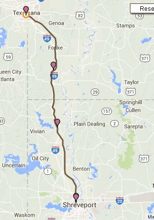
Now lets look at the road. It's 182 miles long so I had to break it up to get any map definition.
Now shown on the far left (west is Vivian). There will be plenty more so don't fret.(directed at all the guitar players out there).
That horizontal line above the road is the state boundary. The yellow line is La.2, the red portion above it is Alt.2.
I should have colored Alt 2, yellow. Too late now.
West Half.

East Half
La.2 ends at the shores of Lake Providence, an oxbow lake formed by the Mississippi R.

As I said:
Railroads will only be a part of this exploration. Lots of local history will be included and beauty contests.
OK, I'll try to straighten the mess up, first. And, it is a mess. This will probably turn you off. Just hold your nose.
La.2 is one of those weird ones that split big time and goes off in different directions at the same time only to rejoin later. On rereading, this is redundant, but possibly required.

I'm only going to use bits and pieces of Wiki's confusing installment.
LA 2 begins at the Louisiana/Texas state line in northern Caddo Parish.
It merges shortly with LA 1 and runs due north.
The highways split (go their separate ways) in Vivian, where LA 2 continues eastward.
In Sarepta, Louisiana Highway 2 Spur connects LA 2 with the L&A Railroad Station. (We'll see)
LA 2 still continues nearly due east into Claiborne Parish
These are the towns starting from the west and going east until the split at Shongaloo.
Vivian (RR)
Hosston (US71)
Plain Dealing (Railroad) (La.3)
Sarepta (RR) (La.7)
Sykes Ferry, Bayou Dorcheat
Shongaloo (Split)
The split. I should have chosen a more detailed map. My old topographic would have worked better.
Maybe both, one for simplicity, the other not. The Wiki writer completely forgot the south route and the
north route (Alt.2) has more except for Homer which is so interesting I wrote a huge paper on it just cause it was something different and Virgil supplied all the pictures. How could I resist?

North Route : Norton Corner, Haynesville (RR) Intersects U.S. Route 79 , Gordon, Colquitt, Summerfield (La.9), Hebron, Weldon, Pisgah US 167 south to Bernice, Rejoins 2
Haynesville is the important one here.
South Route: Leton (La.160, 159), Blackburn, Homer (RR), Claiborne Lake, Lisbon, Bernice (RR)(US 167), Rejoins 2.
Minden, seen above comes into play. There will also be places in Arkansas that connect.
This could have been, and may be at some time, the definitive work on North La. railroads.
As it stands, it ain't much.
 .
..
When you see me note (RR) next to a town or place, that is my signal to include my RR stuff there.
Also, the road intersections will be important when I get to articles w/ pictures about them.
After regaining composure, the road continues east of Bernice are:
Farmerville (La15) Bayou D' Arbonne Lake.
Crossroads
La.143 (RR)
Sterlington (RR) ( joins US 165) (Quachita River)
Bastrop (RRs) (La.139) (La.593) (La.2 continues east w/ US165)
Mer Rouge (RR) (La.2 separates from US 165)
Boeuf River
Goodwill (La.585)
Twin Bridges - Redwing (La.582, La.589)
Oak Grove (La17) (RR?)
Berry, Bayou Macon
Lake Providence (US 65) (RR)
Of course all of that is so I can keep my head on straight as this is really Indian Country to me.
I take that back. I've been there in another life where all was an enjoyable blur with no mission but the mission itself.
Below is what I previously had on Louisiana Hwy 2 before 6/27/2016.
Yes, I did the map but the rest was taken from Wiki, a meager offering which I've mostly eliminated.
The map probably expands when clicked. Back button to return. It is the map I should have used.

-----------------------------------------------------------------------------------------------------------
I have no idea why the line is above.
Here you have the big picture from whence I took the segmented ones above. Redundant, yes.
I promise this will get better.

Finally:

We are going to get started.
Tx.49 ends and La.2 begins.
But first a little boring stuff on the beginning.

Marion was not a woman, his name was Francis Marion.
He was a warrior who used "gorilla" tactics, the original Swamp Fox. I once corresponded with
Marion Smith, named for the same. He was a great source of information, this being some.
Sadly, he is gone. Prior to this knowledge, I only knew "the Swamp Fox" as a bar I attended in
an attempt to forget where I worked.

Here we go east. Of course these are GE Pictures. Most road shots are. This one is a little "tripy".
The yellow lines float from place to place. We will be more directional. We're headed east over the hill.

At La.1, the road turns left (north).

Or, you can go down there and see what "is, is"
Quoting a Clinton can be quoting a lie. Of course to the Clinton crowd, lying doesn't matter, only the gifts
they use to buy votes. Rise up America, you are better than they would have you be.

Up La.1 there is a big RR customer. I cannot get bogged down here.

The thrill of seeing a KCS engine can liven things up. Just being on a new road is enough to raise my flag.

Late into the write and picture / history gathering, I discovered I'd missed the Vivian Depot.
Vivian Railroad Station Museum http://vivianrailroadstationmuseum.weebly.com/
Maps trump depots, always have, always will. Can't have the later w/o the firster.

I've been through Vivian a lot on the way to Oklahoma where I was indentured on a ranch and up into Arkansas where I was a free bird.
Initially looking around Vivian's rail district.


Bingo, there's the KCS depot. Magnificent.


Heading east.
Shown below is the route up to here. Take "2" east.

Vivian to Hosston
La.2 joins La.71 for a short ride north, then leaves going east.
Hosston may have had a railroad at one time (perceived evidence).
Yes. From Here (Abandoned Rails)
Note, La.1 and US 71 are Louisiana's "great" north -south highways.
Here, they almost join again, the last time being in Alexandria.
.


Hosston sits on the east end of Black Bayou Lake. Note, "Water Lillies" are a problem there.
Adam Oliver lived out the fantasy of every angler in the Ark-La-Tex this past week when he hauled in a 15.82 pound bass in the Black Bayou in Hosston. The fish is unofficially the 2nd biggest bass ever caught in the state of Louisiana. Oliver said he couldn't believe the size of the fish when he hauled it in, and says he will release the fish back into the wild soon after it's weight has become official. Until then, the fish is on display at Reeves Marine in Bossier City.
The road dips deeply into the Red River Valley and crosses that river on the way to Plain Dealing.

Interstate 49 has been expanded up here since my last visit during that "another life".
Red River
My mother attended a school in Gilliam.

I pretty much went nuts gathering and reading stuff about Plain Dealing.(RR)
Into Plain Dealing.
The town was chartered April 24, 1890, and was described in the village charter of 1890 as a square, one mile in each direction from a nail in the Cotton Belt depot. Another election was held on August 23, 1890, to amend Section 1 of the village charter regarding the boundary of the town, and the city limits were changed from the two miles square to 1-1/4 miles square. The total population of the community at that time was believed to be fewer than 100. With the coming of the railroad, Plain Dealing began to grow into a prosperous small town.

Looking north from La.2. Depot area? You bet.

South, across La.2.
\
Feed store, that works. It was on the depot's track.

Then from above, it was gone.

May 12, 2014
The National Weather Service confirms that a tornado touched down early Monday morning just west of
Plain Dealing.
Looking North

Looking East on La.2

Looking South, another perspective of the gone building with boxcar doors.

La.2 is East Mary Lee Ave. in Plain Dealing.

Here it gets thick.
Plain Dealing history
An article titled "Plain Dealing — Yesterday — To-Day" appeared in the June 9, 1932 issue of The Plain Dealing Progress. The article is unsigned, but was possibly written by Rupert Peyton.
In 1888 the Cotton Belt Railroad was laid in Plain Dealing and a depot was erected. The sign for the depot bore the name “Guernshein.” Shortly after, the name was changed to Plain Dealing to perpetuate the name of the 5,000 acre plantation which covered the area where Plain Dealing was located. In the same year, lots for the town site were sold, bringing a total of $12,000. B.W. Boggs was elected Plain Dealing’s first mayor when the town was incorporated in 1890. Fire destroyed the town twice, once in 1903 and again in 1906.
Early Plain Dealing merchants and some of their businesses included the following: S.J. Zeigler, a general merchandise store; John J. Swindle, a drug firm; mercantile firms of Nattin & Campbell and Cavett & Doles (where the post office was located); S.J. Cochran; E.F. Kirtley and Kelly Brothers. Mr. & Mrs. Daniel Smith operated the first hotel, and the wife of Mr. Grisdale, the first railroad section foreman, operated a section rooming house.
Along with the railroad, the first school was established in 1888. The Plain Dealing Academy had an enrollment of 56 students. Classes were held in a frame building that, by 1932, had been replaced by two brick buildings with an enrollment of 700 pupils.
Plain Dealing’s first bank was founded in 1906. P.B. Holt was the editor of the first newspaper, The Plain Dealer. The first church was a Methodist church founded in 1888, with a Baptist church following closely. By 1932, a Presbyterian Church was cooperating in the spiritual development of Plain Dealing.
The 1200 residents of Plain Dealing in 1932 numbered among their businesses: the mercantile firms of W.W. Oglesby and W.H. Martin; three drug companies; The Jewell Café and The Home Bakery and Café; A.W. Heifner Hardware Company; S.J. Caldwell Motor Company; three filling stations; offices of Southern Cities Distributing Company; Southwestern Gas and Electric Company; Bell Hotel; one recreational parlor; two tailor shops; one newspaper plant; one ice plant; two gins; one wholesale house and telephone exchange. Typical village roads had been transformed into model streets including gravel and paving.
Early doctors of Plain Dealing included Dr. Davis, Dr. W.J. Baird, Dr. Blackman, Dr. W.F. Bell and
Dr. T.N. Keoun.
In 1932, the oldest citizens of Plain Dealing in terms of continuous residence were Mrs. Roy Bolinger who moved to Plain Dealing with her parents when she was three years old, and W.E. Swindle who moved to Plain Dealing when he was a small boy. Next in line for the honor of oldest resident was Mrs. Mollie Banks Gray who moved to Plain Dealing in 1897.
Below is from Here. It is another Plain Dealing history with a different emphasis.
My great aunt is the lady mentioned below.
Plain Dealing today still celebrates its dogwoods blooming in the spring on the first Saturday in April of every year. Today, a large parade and an all-day street festival is held. (Read the poem "Land of Dogwood Trails" written by Emma Wilson Emery, Poet Laureate of Louisiana.)
Great Page on Cotton Belt RR.
These are some plucked pictures.

Looking north on Lynch St.


About the RR.
The St. Louis Southwestern Railway, fondly remembered as the Cotton Belt Route, was a southwestern/Midwest system that stretched from Texas to Missouri and St. Louis (via trackage rights with the Missouri Pacific). While the railroad was controlled by the Southern Pacific beginning in the early 1930s it maintained its own identity and operations until the early 1990s when it was finally formally merged into the SP system (the railroad also maintained its own paint scheme, although it was essentially a version of the SP livery with SSW markings). Today the former lines of the Cotton Belt Route are part of the Union Pacific’s massive system and still remains an important corridor under the UP banner.
The St. Louis Southwestern Railway is often times forgotten about as a fallen flag, or railroad altogether, since it came under the control of the Southern Pacific in the 1930s and never had its own, true paint scheme and identity like nearly all other classic fallen flags so dearly remembered today. However, the Cotton Belt Route became an important rail artery between Memphis/St. Louis and east Texas/Arkansas when it was first created in January 1891 from several other smaller systems. While the railroad maintained a system of around 1,500 miles throughout most of its history in the early 1980s it reached its largest length of over 2,100 miles after it had acquired the Rock Island’s former main line between Chicago and eastern New Mexico, the famous Golden State Route.
This view of Plain Dealing was taken in the 1920's. Looking west on Palmetto, the firsst building on the corner is the Kidd Building. The last distinguishable building on the right is the depot.

This was how the route went.

Next, we're on to Sarepta. (RR)

Sarepta Link: http://nwla-archives.org/handbook/sareptaLouisiana.htm

More intrigue.


Then it dawned on me. I was on the Louisiana & Arkansas RR's main line.
This railroad has been my favorite because of much of it was built by Edenborn. The rest of it was built by his arch enemy, Buchanan. They squabbled like two old women. What a cat fight.

Sarepta rail life did not seem up to main line standards, but they were at one time and still in service.
This is probably the original depot site.

Looking north on the rails.

The next crossing up the way looked better.
I had to follow these rails north.
The rails end at Cullen, but I stayed with the scar going north.
At Taylor:

Probable depot location in Taylor.
So, who was Taylor? That would be General Richard Taylor, CSA.
I think about his frustrations. They put mine to shame.
I have no idea where my middle name came from. I can only hope he was the source.


Down AR 53 from Stamps is a L&A trestle. This was a find.

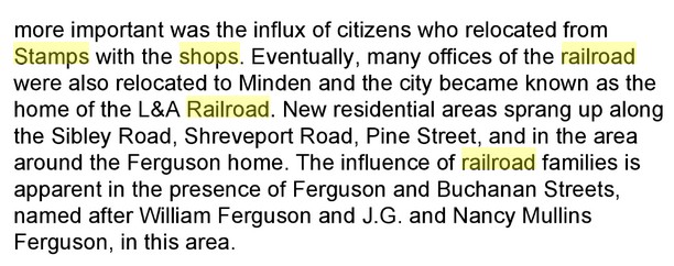
At Stamps Arkansas.
The L&A Shops were originally at Stamps.
I just visited the Wiki site on the L&A. Quote, " Buchanan's partners were Harvey C. Couch and William Edenborn. This is why you do not trust Wikipedia. William Edenborn just rolled over in his grave. Harvey is still shaking his head.
From the AR tourist site:
Stamps is a small town located in Lafayette County. It is the only town in the nation named ‘Stamps’ and is around 2.5 hours from Little Rock. The town was named in honor of Hardy James Stamps, an early settler of the area, and was the childhood home of author Maya Angelou.
The town was a flag stop on the St. Louis and Southwestern railroad (known as “The Cotton Belt” line), which was put through town in 1882. The first Post Office was established in 1887 and the town was incorporated the next year with J.W. Parkers serving as first mayor.
Early Stamps owed its development to the lumber industry. At one time the town had the largest sawmill in the South. One of the largest of these lumber mills was the Bodcaw Lumber Company of Louisiana which was in town from 1889-1931.
From a small beginning, the company became the target of three major corporations. After the mills were built and in full operation the town was thriving by 1899. The company included two saw mills and a tramway that eventually grew in the Louisiana and Arkansas Railway Company, later a part of the Kansas City Southern Railway System. The mill was associated with the interests of William Buchanan, the largest manufacture of yellow pine lumber in the world at the time. The area also has oil production with the Dorcheat, Stamps-Lewisville, and Bodcaw Fields nearby.
Below, it seems the L&A connected to the Cotton Belt.

Dug up rails & ties at the end of AR 56 below Stamps.

Spring Hill, La.


Entrance on KCS Rd, Minden Shops..


Oh, yes. We were at Sarepta, a Bible bribing lady's name.

And that ain't all:
SAREPTA, Louisiana. Sarepta is a small community in Webster Parish, Louisiana, about twenty-five miles northwest of Minden, the parish seat. Early settlers in the area were William S. Denman, who purchased one hundred sixty acres in October 1848, James M. Butler, and Simon D. Moore, who settled there in 1850. The named originated about 1868 with a small country church that was named after Mrs. Sarepta Carter, who donated a Bible for the pulpit. The church became known as "old Sarepta Baptist church." A decade later, J. I. Allen built a small general store about a half mile from the church at a spot known to neighbors as "Old Hickory Tree." The store was referred to as "the store over at Sarepta," and eventually a settlement comprising the store, church, cemetery, and few small farm houses took the name. A post office was established and the name Sarepta was formalized in 1884. J. I. Allen became the first postmaster.
In 1898, the Louisiana and Arkansas Railroad secured right-of-way and started work on a road in the vicinity and J. I. Allen was made the depot agent. In 1920 the Bank of Sarepta was organized and a variety of businesses began to appear. In 1923 a deep water well was drilled. The first drive in gas station, The Standard Oil Wholesale Station, and a telephone exchange were added the following year along with a pipeline to Beaumont, Texas, opening a vast market for natural gas, which proved abundant in the Sarepta area.
Various buildings at different sites filled the educational needs of the area, the first being a crude log structure erected in 1853. It was a one-room log cabin heated by a large open fireplace. Benches and other furniture were made from logs. The cabin served until 1920 when a more modern school building was built that included Sarepta’s first high school.
Sarepta received another economic boost in 1937 with the construction of the International Paper Company mill at nearby Springhill. The town was incorporated in 1955 and Richard Griffin was elected the first mayor. By 1971, the population had grown to 1,000. The population was 925 in 2000.
Bibliography: Emily U. Miller, The History of Sarepta (Shreveport, LA: Tobey Printing Co., 1924-25); Tommie Blunt O’Bier, North Webster Parish, The Early Years. (Shongaloo, LA, 1996); "Sarepta," Webster Parish Centennial. (Minden, LA, 1971).


More Dang History:
Rails to Stamps by Willis (I think)
When William Buchanan started his timber acquisition march southwards from Stamps, Arkansas in the late 1890's, he was one of the mechanization moguls who recognized the importance of the railroad as the prime source of transport to insure success in the lumbering business at that time. After Buchanan first got his mills up and running at Stamps, Springhill and Minden he was tired of the old outdated locomotives and poorly maintained tracks he had inherited from the purchase of the Stamps, Arkansas mill, so he personally took on the task of vigorously upgrading what would become the Louisiana & Arkansas rail system. In fact, he was so in love with the construction of the L & A that he considered his sawmills of secondary importance, and even decided to oversee the renovation of the old line and the laying of the new rails himself, and becoming a familiar sight at end of track, shouting orders from raised windows of his plush rail car named the "Catahoula". Buchanan was considered a miser in other aspects of his Timber Dynasty, but when it came to railroad construction and maintenance of his rail line and equipment, money was no object, resulting in the line's estimated worth in 1910 at over $10,000,000.
He might have been considered a horse's "arse" by his peers, but at his death in 1923 the L & A was the best, most profitable, and most efficient rail systems in the Deep South, and other railroad magnets like J.P. Morgan and Jay Gould journeyed south to study his modus operandi. Buchanan constructed one of the most elaborate, expensive machine shops, complete with a roundhouse and turntable, in the United States. The Stamps shop, by utilization of the turntable, could turn a locomotive and position it over different bays where any and all mechanical problems could be properly addressed.
Mr. Herbert Tannehill was Chief Construction Engineer until the line reached Trout, and after laying out the mill town, Mr. Tannehill no longer wanted to be dominated by the overbearing Buchanan clan so he simply quit their employ. Needing to extend the line on to Jonesville, thus opening up a venue to eastern markets, he contacted the Missouri Pacific Railroad Line Officials and procured an engineer on loan in the person of Mr. E.J. Lassiter, Sr.
When the line was completed into Jena with the first train arriving in what was old Jena on December 31st, 1903, there was no depot and when attempts were made to purchase land on which to erect one on, land sales were denied the company. The stand taken by the good citizens of Old Jena was because that they were fearful that establishment of a depot in their elitist neighborhood would draw hobos, bums, and a generally undesirable class of secondary rabble to their community and they simply wouldn't stand for it. The company simply moved back up the line about a mile and hastily erected a depot at what would become New Jena in order to have an embarkation point for the first passenger train, which arrived in New Jena on May 1st, 1904. By 1907 the line had traversed the Brushley swamp east of Rhinehart, La and had been laid into Jonesville to tie into a pre-existing line called the New Orleans & Northwestern Railway.
This tie-in enabled William Buchanan to then utilize his connection on the western end to the St. Louis, Iron Mountain and Southern railroads to give valuable access to both northern and eastern markets. In 1917 he shipped out enough board feet of lumber from the Good Pine Lumber Company mill to construct the complete town of Lincoln, Nebraska. When his engineers arrived in Jonesville with the L & A, they found that the NO& N R.R. was a narrow gauge line with the smaller rails only three feet apart, but not to be dismayed, they sent the line locomotives back up to the Stamps machine shop where the steam engines and rail cars were fitted with an extra set of wheels to enable them to travel the US standard gauge line with a 4 feet, 8. 5 inches width between the L& A rails and then transition to the narrower, smaller 3.0 width rails coming from Natchez.
Many questions have been raised as to why railroads being built today in the US use the odd measurement distance between rails utilizing the US Standard gauge and here is the reason why. The roads are built that way because that's the way they were built in England, and the people over there who built pre-rail-trams ways used that spacing, and these English émigrés to the US used the same jigs and tools that were used for building wagons in the US as they had in their native England. If the English wagon makers had tried to utilize any other spacing the wheels would not have followed in the ruts first made by the chariots of Imperial Rome during Julius Caesar's rule of Britannia.
The United States standard railroad gauge of 4 feet, 8.5 inches is derived from the original specifications of a Roman war chariot. So the next time you wonder why some horse's "arse" came up with such an oddball measurement, it's because Roman war chariots were built just wide enough to accommodate the rear ends of two war horses.
And you've been thinking all this time that being a HORSE'S ARSE was not important, but William Buchanan would have probably argued in defense of that calling.
A refresher.

The Town of Cotton Valley, is down the line south of Sarepta.


Cullen is up the tracks and near Spring Hill
Remember, Cullen is where the present rails were found to stop.


Later:
The Louisiana Southern Railroad (LAS) began operations September 25, 2005. Watco Companies acquired the railroad from the Kansas City Southern (once the KCS / L&A RR) through a lease agreement.
The LAS consists of 157 miles of track. The northern branch runs from Shreveport to Sibley, then north to Springhill, La. Additionally, the southern branch runs from Gibsland to Pineville Junction, La. The LAS interchanges with the KCS at Gibsland, Sibley and Pineville, La.
I didn't see anything above Cullen.
But, I do have a picture of the Bienville Depot.

Added information has to be placed here .... right now or I will lose it. Just scroll through this stuff if not interested.
This is RR Info concerning Louisiana and primarily, north La.
Three Class 1 Railroads Serve North Louisiana
Union Pacific Railroad (UP) is the largest Class 1 railroad in the North America, covering 23 states across the U.S. It serves all major gateways to Mexico and interchanges traffic with Canadian rail systems.
Kansas City Southern (KCS) is a Class 1 railroad that operates 3,100 miles of rail line in ten central and southeastern states and offers rail service between the U.S. and Mexico.
Burlington North Santa Fe Railway (BNSF) is a Class 1 railway, headquartered in Forth Worth, Texas. BNSF operates in Caddo Parish, Louisiana and utilizes UP tracks from Logansport, LA through Shreveport, LA to Texarkana, AR.
These are the ones we'll encounter along the way.
They are here today because historical railroads "paved" the way.
Short-Line Railroads Provide Additional Connections
Louisiana and North West Railroad (LNW), owned by Patriot Rail, Corp, is a short-line road operating 62.6 miles line from McNeil, Arkansas to Gibsland, Louisiana. L&NW recently built a 40 acre industrial park and transloading facility located near Interstate 20.
Louisiana Southern Railroad (LAS), owned by Watco Companies, operates 157 miles of track, running from Shreveport, LA to Sibley, LA. The southern branch runs from Gibsland to Pineville Junction, LA. LAS interchanges with KCS at Gibsland, Sibley and Pineville, LA.
Arkansas & Louisiana Mississippi Railroad (ALM) operates freight service from Crossett, AR to Monroe, LA (53 miles). ALM connects with KCS at Monroe, LA and Franklin and Pittsburg Railroad at Crossett, AR.
Covering the LAS


I'm bogging down. Start Me Up!
Heading east from Sarepta:


We arrive at Shongaloo where we will do the north route, first.

Shongaloo seemed to be a "wide place in the road".

But, of course it isn't.
Cut from various articles that were obviously poorly scanned.


From http://www.mindenmemories.org/Shongaloo.htm
1850-1910 The Children met in a one room building in the Union Springs School and paid tuition with farm products.
1866- Old Shongaloo School was established. The building was purchased for $150.00 It continued until July 6, 1926. It closed when the students went to the new school in Shongaloo.
1890 - Hall School was established in 1890 and was opened until Jan. 14, 1910 when the students were sent to New Shongaloo.
Matthew School - Little is known about this school. Miss Lawson Waters taught at this school in 1907 Vera Wise Sanders also taught here. It closed Sept. 1915 when it consolidated with Old Shongaloo.
1909 - Tony McEachern School petitioned for a school and was open for four months and was in operation until September 1915.
For several years Slack School was the most important school in the community. it was open for four months in 1908. Later a small house was open for the students who went there. Records show that it closed on January 12, 1912. The students were carried by wagon to New Shongaloo.
1910 - A new building was built across the road with a back porch on which the children ate their lunch, usually brought in a syrup bucket.
Sike's Ferry School was open between 1903-1915 and was tuition free. When the school closed they were sent to Shongaloo. The abandoned building was sold to A. Hadaway.
A school was allowed at Leton on April 3, 1908. It was opened for five months. On September 3, 1912 the board deeded the property to the Leton Union Church.
In 1927, the Leton Community was authorized the school for church and community activities. A new school district #30 was created in 1929, to be known as Evergreen-Leton-Old Union Springs District. Children attended School at Evergreen.
In 1921 the Community divided between two schools; Old Shongaloo and New Shongaloo..Log Cabin, Potters, Freezeout, Hall's, Slack's, Ferry, Leton, Accident, and Union Springs were all fused into the New Shongaloo School.
McEachern (Tony) and Matthews had become a part of old Shongaloo school.
Evergreen consolidated with Shongaloo in 1957.
"Old Shongolloo"
http://lakebistineau.com/history/History/DATES%201.html
It was about 1700 that a band of Choctaw Indians set up a village just east of Bayou Dorcheat near what later became the present day Shongaloo. It is believed the name Shongaloo came from the Choctaw name "Shakalo" meaning cypress tree. Shongaloo also means running water and the Indian trail passing the springs there was called "chicken-in-the-trail". The present highway coming from the northwest and veering to the east after passing the old Shongaloo church follows the original Indoan trail. A large Indian mound called "Wauhoo Ridge" was located there. A skull, pipe, several tomahawks, pottery and stone implements have been recovered from the area.
1871- Webster Parish was created in Feb 1871 with the Parish Site at Minden. The parish was fiscally healthy with Cotton Valley, Murrell's Point, Shongaloo, Taylors Store and Germantown providing small business centers. The Minden landings, Murrell's Point, Noles Landing and Port Boliver were principal shipping points on the lake and bayou. Between 12,000 and 15,000 bales of cotton were being shipped yearly from Minden landings and about twice that quantity from the Lake Bistineau landings.

Into Haynesville

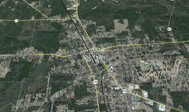
Rolling into Haynesville, I noticed this red brick building by the tracks.
It was a fancy building for a small town depot.


What is that????


The parent company, the Louisiana North and South Railway Company, was chartered on November 28, 1885, under the laws of Louisiana, to construct a railroad from Gibsland, LA to Homer, LA, a distance of 19 miles. Its construction was not commenced, however, until August, 1887. It was opened for business early in 1888.
The company was reorganized as THE LOUISIANA AND NORTH WEST RAILROAD COMPANY, which was chartered under the laws of Louisiana, on December 3, 1889, for 99 years, and was projected to run from Alexandria, LA to Hope, AR, a distance of 230 miles.
In 1890, an extension was built from Gibsland to Bienville, LA, a distance of 15 miles. However, completion of the road to its southern terminus at Natchitoches, LA, 44 miles, was not effected until about 1901.
In 1898 the line was constructed from Homer, LA to Magnolia, AR, 36 miles, and in November, 1898, opened for traffic. In addition to this, another 6.4 miles of track from Magnolia to McNeil, AR, was leased from the St. Louis Southwestern Railway Company (now the Union Pacific Railroad Company), under contract dated April 27, 1897 and revised January 1, 1923.
RECEIVERSHIP
On August 23, 1913 the company was placed in the hands of a receiver. Under the receivership, the property declined to such an extent that in July, 1919 when it was advertised for sale with an upset price of $500,000.00, there were no bidders. The court became dissatisfied with the administration of the affairs and on October 1, 1920, appointed E. R. Bernstein of Shreveport, LA as receiver.
The new receiver found operations had ceased because the roadway and equipment were no longer fit for service and because there were no funds with which to pay wages and current obligations. He addressed himself first to restoration of the service and the morale of the employees, then to the rehabilitation of the track and rolling stock. Soon the road was capable of transporting the increased volume of tonnage then offered, although not until after having suffered the loss of a considerable amount of the traffic that commenced to move following the opening of the Homer Oil Field in January, 1919.
Upon application of the receiver, the Railroad Commission of Louisiana on February 11, 1921, authorized the cessation of operation of 22.2 miles of railroad extending from Chestnut, LA to Natchitoches, LA, and on August 24, 1921, the Interstate Commerce Commission authorized the abandonment of that portion of the line. This action was of considerable benefit to the Company since that section abandoned had been operated at a loss, entailing a burden on the remainder of the line.
Mr. Bernstein continued as Receiver until May 21, 1922, when the court ordered the property restored to the Company.
In 1949, the Company received approval from the Louisiana Public Service Commission and the Interstate Commerce Commission to abandon the portion of the railroad between Bienville, LA and Chestnut, LA. About this same time, the Company sold their portion to the railroad between Gibsland, LA and Bienville, LA to the North Louisiana & Gulf Railroad.
Therefore, at the present time the length of the railroad is 61.5 miles, operating a freight train daily, except Wednesday, Saturday and Sunday, and alternating directions every other day, between Gibsland, LA and McNeil, AR. The railroad has connections at Gibsland, LA with the Kansas City Southern Railway Company and the Louisiana Southern Railroad (a division of WATCO Company), and in McNeil, AR, the company connects with the Union Pacific Railroad Company.
Our timetable file dates back to 1905 when passenger trains were being operated. In 1948, however, the Company ceased to operate passenger trains. In that same year (1948), the L & N W Railroad became the first railroad in the United States to be completely operated by radio.
On August 1, 1970, an immense rebuilding program was initiated. Between Magnolia and Gibsland, bridges were rebuilt using new creosoted materials, new crossties were installed, the track was raised by 4 inches, and new rock ballast was added.
In 1991, and for the first time in the history of the L & N W, a reroute order was issued. Due to the devastating flood in May of that year, track was washed away to such an extent that no trains could operate. Water rose so rapidly that headbolts were pulled through crossties and bridge stringers, moving the mainline some 20 feet downstream. In some cases, complete sections of track were completely washed away or left dangling 5-10 feet above solid ground. Between May 1 and May 15, cars destined to L & N W’s north end customers traveled via the MidSouth Rail Corporation (now the Kansas City Southern) to Shreveport and thence the Cotton Belt Railroad (now the Union Pacific) to McNeil, AR. Since recovering from the flood, the L & N W has invested well over $2 million rehabilitating its track structure.
The L & N W is extremely proud of our customers and our employees. Hard working and dedicated to improving the community as well as the company, our employees are some of the best in the world.
Railfans and railroad enthusiasts from as far away as Australia have visited the L & N W over the years. This shows that, no matter how small you may be, your reputation may reach much further than you dreamed. Several full-length articles about the L & N W have appeared in national magazines such as “Railroad Modeler” (December 1975), “Railroad and Railfan” (April 1978), and “Trains” (May 1985)


HAYNESVILLE By Joyce B. Dobbins Historical records reveal the earliest settler in the Haynesville community to be a Widow Long who established a residence in 1818, but she moved very shortly to Arkansas. Not until some twenty-five or thirty years later was there to be a tidal wave of migration into this area. J. C. Wasson and L. S. Fuller came in 1844, Hiram Brown in 1845, Miles Buford and Samuel Boyd in 1846. In 1848 J. C. Taylor migrated from Georgia and settled in the community now known as Old Town, buying 160 acres of land at 75 cents per acre from the government and establishing a small country store, so that Haynesville was first known as Taylor's Store. J. C. Taylor expanded his business enterprises and donated land for the first Methodist Church, cemetery, and school house built in 1860. The school's first teachers were Tarpley Winn and Thomas Beck. Other Old Town businesses include a drug business owned by Sam Kirkpatrick and Dr. Wroten, a jewelry shop operated by a Mr. Wood. Mr. Stone was a carpenter, Mr. Ray was a coffin maker, and Captain Maddox, John Brooks, and Lindsey Mosely had general stores. This community steadily grew, and by 1898 it was a thriving village of some 250 people, covering a mile square, and serving many families within a ten mile radius. The community acquired the name "Haynesville" from a certain Captain Haynes who lived there temporarily. Saddle-pocket preachers and bush arbor services held important places in the religious life of early Haynesville pioneers. These ministers traveled the country on horseback bringing the word of God. These sacks thrown across the saddle held the Bible in one end and their clothes in the other. Early saddle-pocket preachers were Tom Brasher, Rufus Neal, Hollis, Idson and M. C. Parker, Back in Old Town days, Haynesville was not incorporated, and government consisted of constables and justices of the peace who occasionally held court. Haynesville's first post office dates back as early as 1849 when the mail was brought from Homer and placed in a showcase of Brown Brothers' Store. Journalism was introduced in 1879 to Haynesville by John Warren and J. M. Hendry, who edited a Political paper called the Greenback Dollar. It was printed until 1889, and J. M. Hendry took over editorship of the Haynesville Star. From 1887 to 1893 Haynesville had a Normal Institute for teacher training headed by Phillip Gibson, nephew of J. C. Taylor. It was under Mr. Gibson's guiding hand that the Haynesville Star was first published. In 1898 the shrill blast of a train whistle marked the dawn of a new era for Haynesville. The residents bought three hundred acres of land and gave it to the L. and N. W. railroad company so that the town would be placed at its present location. Major J. D. Beardsley, promoter of the railroad, sold the land in lots to finance its completion. Two hundred acres were bought from C. A. Bridgeman at $6.25 per acre, 60 from J. W. Camp at $10.00, 40 from G. B. Sherman at $7.50 per acre. Major Beardsley plotted a map of the town and named the streets with such early family names as Dawson, Gantt, Greer, Taylor, and Bailey. Within a few years Old Town ceased to exist and new businesses were brought in as well as old businesses relocated. Jo Greer and George Sherman built the first store in August, 1898. The first depot was a box car which was used for three or more years. T. W. (Tom) Camp was the new town's first barber. Shortly afterwards John Sale began to burn brick kilns; W. A. Waters and Hugh Miller built the first brick stores; T. U. Norton, Tom Sale and S. B. Baucum followed with brick establishments. When Haynesville was incorporated around 1899 frame buildings were outlawed. In 1904 John Henry was elected the new town's first mayor and S. E. Rankin was made its first marshal. Practically overnight, in the early part of 1921, Haynesville mushroomed from a peaceful little town of 1,000 inhabitants to a oil boom town. Tents, shacks, and lean-tos were thrown up to provide lodging and food for both workers and oil speculators. "Liquid gold" gushed forth on March 30, 1921, bringing in untold wealth which was followed by a building boom for new residences and business establishments, churches and school buildings. The condition of the roads and streets during the oil boom is vividly recalled by those who lived through the boom. A mule drowning in mud and slush on Main Street was a topic for conversation for many days during this time. The same is true for the youngster, a very enterprising young business man who took advantage of the situation, placed "2 x 12's" on blocks across the street and charged five cents to walk across. Rural mail carriers resorted to horseback to get the mail to its proper destination. Haynesville's progress can be attributed to many, many people. To list them all would be an extensive project, but names of a few families that have helped to make Haynesville a progressive town are as follows: Dawson, Greer, Brown, Waller, Sale, Sherman, Beene, Miller, Norton, Camp, Callender, Ware, Harp, Almand, Garrett, Rankin, Burns, McEachern, Lowe, Bond, and many others. Since World War II the importance of cotton in agriculture has been replaced with beef cattle, dairying, and forestry.
Haynesville West

Zooming Out
Gordon:
GORDON By Agnes Caston Ware Seven miles east of Haynesville, "Gordon was founded Dy Dr. Gordon years before he moved to Texas." (1) Somewhere in the early 1900's Gordon was a thriving community, with post office operated by Oat Smith, (2) a gin, a grist mill, a general store run by Marshall Lewis, Madden's Store, a schoolhouse, and possibly a saw mill. (3) One of the students at the school was Willis T. Owens, Sr., who lived at Gordon most of his life, and who ran a general store for over half a century. The last store Mr. Owens built stands mute and empty now, with only the fading letters "Gordon, Louisiana" to remind one of its senior citizen, while across the highway only rubble is left of the once lovely home, with huge wisteria vines hiding the fences and large crepe myrtles marking off the boundaries of the yard. Two colored churches, two white cemeteries, and a well-kept community house are all that remain of the old Gordon, the latter being the old school building, where revivals are still conducted, funerals, and old-fashioned all day singings, with "dinner on the ground." 1. Biographical and Historical Memoirs of Northwest Louisiana, The Southern Publishing Co. 2. Stories of Dixie, James W. Nicholson, American Book Co., copyright 1915, p. 120. 3. Inforination furnished by Finis Bailey, born and reared near Gordon, who now lives in Haynesville.

Gordon to Summerfield
The L. & N. W. railroad entered this parish in about 1887 or 1888. There was much excitement and rejoicing over such an improvement as all our travel to that time was done by covered wagons, buggies and surreys. The U. S. Mail was brought over by team and when the carrier reached town he blew a horn to let people know the mail had arrived. Everybody flocked to the "post office" to wait until it was opened.

Summerfield to Bernice

Shifting to the south loop.

The black line is the railroad.

I'm going to save some time and send you on a link to my / our fantastic write up on Homer.
CLICK HERE to open in a new browser page. When finished, just delete it.
Below is only an explanation of how Homer got its name.

More on Homer not included in that write.
How could there be more?
H0MER By Lily Kiiiabrew Phillips Homer, which superceded Athens as the parish seat of Claiborne, bears a name chosen by Frank Vaughn, son of Tillinghast Vaughn who helped lay out the town around a public square, about 1850. The choice of a name can be explained in the interest in the classics which characterized the times. The name of the local newspaper, the Illiad, the classical style of the courthouse, the names of nearby communities - Athens and Sparta - are further indications of this interest. By 1860 Homer was a flourishing incorporated town, with approximately 700 inhabitants. A description of the town in 1886 is found in a rare booklet by F. H. Tompkins entitled North Louisiana: its soil, climate, productions, health, schools, etc., coupled with its timber and mineral wealth, also embracing a description of its various towns, prospective and completed railroads, and printed by the A. H. Pugh Printing Co., Cincinnati. Excerpts which follow provide not only light upon the history of Homer, but upon the journalistic style which was in favor at that time: "Dotted down among the iron clad hills of Claiborne is the charming and peerless little city named after the great Grecian bard. As will be seen from the account of Claiborne, it ranks among the finest of all the hill parishes of our state, and its people as possessing all the traits of real ante bellum hospitality. So is this little city like its surrounding. Its inhabitants are generous, whole-souled and hospitable, and possess the rare intelligence that always shows itself so plainly in those towns which have always had good schools. The schools of Homer have always been presided over by teachers of the very highest excellence. The Homer Masonic Female Institute has ushered from its portals girls whose subsequent careers, as mothers, wives, authors and teachers, have added lustre and fame, to their alma mater, and culture to the community within whose limits their lives have been spent. The Homer Male College has laid the foundation of many a collegiate education, and furnished many a bright boy all his parents were able to give him to battle against the world and make life a success. The votaries of mixed schools, of males and females, have gained the ascendancy, and these two honored institutions are now one, presided over by a gentleman of scholarly attainments, crowned with habits of piety and religious devotion. Situated in the midst of a people of thrifty and frugal habits, Homer's trade has always been very large. New trade centres, brought into existence by lines of railroad, have diverted its trade from a distance to some extent, yet its local trade has increased with the increase of population, and it enjoys a fine trade now. For a town of its size it has quite a large capital employed. A detailed statement of its business houses is as follows: A. E. Wilder. Dealer in dry goods and jewelry, does a large business almost exclusively for cash, and carries a beautiful stock of fancy goods, jewelry, etc. Mr. Wilder was for many years the confidential bookkeeper for A. McCranie. Embarked in business for himself in 1882, and has a good line of customers and plenty of friends. C. 0. Ferguson. In 1880, three young men, clerks in stores, who had saved their money, embarked in business together. They were Fayette Camp, A. H. Davidson, and C. 0. Ferguson. . . . They stepped into a fine business. In 1881, Mr. Camp withdrew, having sold his interest to the remaining partners. In 1884, Mr. Davidson withdrew, leaving C. 0. Ferguson the sole possessor of the fine and growing business. His friends are many... G. G. Gill. Mr. Gill is doing a general mercantile and advancing business. He is an old and esteemed merchant . . . an enterprising man and noted for his liberality. His store is on the north corner of the west side of the public square. J. K. Willet. A very deserving young man, who . . . by untiring industry, close economy and strict attention to business has built himself up an excellent business in the general mercantile and advancing line . . . Joseph Shelton is a young gentleman who has made the drug business a success. He is affable and courteous, and possesses a line of customers that no one can take from him ... J. W. Clingman is a young man who has recently embarked in the drug business . . . Mr. Clingman merits and receives a fine trade. W. J. Taylor commenced business in 1876 with but a small capital. He has been doing a general mercantile business on a cash basis since, and increasing his capital, year by year, until he now enjoys a good trade and carries a good assorted stock. Willie Tankersley is doing a retail business in the grocery line. He is a native young man and yet a minor. He may be numbered among the largest and staunchest of Homer's merchants some day. Otts & Allen. Two popular and enterprising young men, bought out the livery stable and stock of J. O. Tankersley, who had for many years done a fine business in Homer. This stable runs a daily line of hacks to Arcadia, and furnishes A 1 teams to drummers. Ragland & Taylor. This stable is managed by Mr. R. P. Ragland, the senior partner, an old and popular livery man. He has a first-class stable, with first-class stock and conveniences. Brown's Hotel. Kept by Mr. W. W. Brown, is a very large and commodious house, built within the last few years. It is the business center of the town. Hamilton House. Another hotel, is also a large house and eligibly situated near the Brown Hotel. Ott's House. This is kept at the old Ward House by Mr. W. W. Otts, a gentleman formerly in the mercantile business in Homer. It is popular with the traveling public. Clingman Nurseries . . . These extensive nurseries are now in their 14th year. They embrace every family of fruit trees that are adapted to our climate ... There is perhaps no nursery in existence in the United States to-day that has such strict rules with regard to the proper representation of trees. If a canvassing agent should misrepresent or mislead, to sell, it is deemed sufficient cause for his immediate discharge. Mr. Clingman pays his employees stated wages, and consequently can better control them in this matter than those nurseries which employ their men on commission, and allow them to make any statement to effect a sale. Trees, vines, shrubs, etc. grown at this nursery have all the advantages of acclimation, which is a great desideratum and one not possessed by Northern dealers. This nursery also prefers to replace any trees which may die or fail from any cause, than let the loss fall on the purchaser..." {Also see "Page 30-Announcements" in the corresponding photo album located in the Claiborne Parish LA GenWeb Archives.} **********
Added will be Junction City, up north on the state line because of its rail history.
JUNCTION CITY By I. A. Brinker Junction City became a town on Sept. 27, 1894. The town came into being when the Arkansas Southern Railroad, later the Rock Island, was extended to that point by a Mr. Henderson, who named Junction City. On the day the railroad reached the site a barbecue was given, supervised by Mr. A. J. Brinker, a citizen of the community, and a public sale of lots was held. Many people of surrounding country came - many to buy lots - and many old people saw a train for their first time. The first business house was built by the railroad and managed by a Mr. Couch. Many places of business were soon built. Some of the first of these merchants were, Mr. Al Curby, and Simmons, Muse and Harris, and Jessie McDonald, druggist. Descendents of these families still live in Junction City. An abundance of virgin pine and oak timber grew here and many homes were built. Saw mills moved into the surrounding country and operated for many years. We are in the unique position here on the state line of having two sets of town officials - one on the Arkansas side and one on the Louisiana side. Most of the businesses are located on the Arkansas side - the post office, bank, schools, and churches, although the railway depot is on the state line - half in Arkansas and half in Louisiana. In the early days, a water well was located in the middle of the street on the state line, half being in Arkansas and half in Louisiana, with the southwest quarter of the well in Claiborne Parish and the southwest quarter in Union Parish. This well furnished water for the townspeople and a watering place for animals riden or driven into town by those who came to buy or sell. Now U. S. Highway 167 is routed through the main street and covers the location of this well. In that time cotton and corn were the money crops and source of income for the surrounding territory. Several thousand bales of cotton were sold yearly to buyers here. Today there is no buyer here, and only one cotton gin operates in this territory. Dairying, cattle-raising, truck gardening,-- timber and some cotton-are the chief sources of income to farmers.
**********
Here we go: This ties in nicely because the rails link Junction City with Bernice, where I'm calling it a day.

This is the 1901 map.


Or you can download the whole thing HERE.
Bernice, where the two 2's meet.
Bernice Depot Museum.
Bernice Depot Museum and
Captain Henderson Caboose
Hours:
Monday - Friday
10:00 am - 12:00 pm
1:00 pm - 3:00 pm
Admission Free (Contributions Accepted)
Administered by the Bernice Historical Society
The Depot
The Bernice Depot Museum was built about 1899 when the railroad first came to Bernice, and it served as a depot for the Arkansas Southern Railroad and for the Chicago, Rock Island and Pacific until the latter ceased operation in 1984. As far as can be determined, it is the only standing Rock Island depot in Louisiana that has not been significantly altered for other purposes, moved from its original site, or simply destroyed.
The building has a Main Room, a Rock Island Room, a small office, and a rest room. The Rock Island Room holds artifacts and paper memorabilia from the defunct rail line, many of which were donated or loaned by former Rock Island employees. Among a variety of Rock Island hand tools, there is a rail carrier. Looking like some large strange pair of pliers, two of these and four men were needed to lift a steel rail and set it in place.
Artifacts permanently on display include a handmade wooden ox yoke bought by pioneer Porter family on their trek from Alabama. The heavy contraption was used to keep the beasts together while they were pulling a wagon or plow. A handmade spinning wheel with a similar history comes from the T.K. Phillips family, and a foot-pedal powered job press was donated by Kelly Printers. Medical instruments used by local doctors, and loaned by Dr. W.C. Reeves, fill a white enamelled cabinet in one corner.
Changing exhibits run the gamut from work of early local artists to a display of locally excavated darts, arrow, and spear points from Bernice archeologist James Harty. Exhibits are presented to coincide with significant dates, i.e. "Black History" in February, baseball in summer, and patriotic programs for Memorial Day, July 4th, and Veterans Day.
The Caboose
The Captain Henderson Caboose is a 1939 wooden railroad car that was probably one of the last of its kind. Child-height display cases contain originals and replicas of toys popular in the 19th and 20th centuries. North and South sections of the caboose are divided into four time periods. Traffic through the rail car is one-way north to south, and entry through the north door brings one into the 19th century, with 1801-1850 on the right. Hand made articles including the balancing man, the sky hook, the thaumatrope or "Wonder Turner", and the phantascope or "Magic Disc". All are for hands-on use, and how-to instructions using readily available materials are given to visitors. On the left, in the 1851-1900 section, a playable toy baby grand piano shares space with late 19th century dolls.
Traversing the upper portion of the middle section of the Caboose, a Rock Island engine pulls an assortment of rolling stock around a circular track. The center section is mixed vintage and features dolls, HO guage railroad locomotives, and assorted cars. More modern offerings, 1901-1999, are found in the Southern section of the Caboose. Tinker Toys, steel and plastic wheeled vehicles, and game sets are among the exhibits.
Wiki / Bernice
The area was part of the Louisiana frontier and pine forests, but early houses survive from the mid-nineteenth century: among the oldest homes are the R.T. Moore/Gresham/Stenzel House, known as the "Sweet Onion", and McCuller Log Cabin, both circa 1865.
Bernice was established in 1899 as a sawmill town after Captain C.C. Henderson built the Arkansas Southern Railroad, the first railway in Union Parish. Also an agricultural trade center, Bernice is the youngest European-American town to be founded in the parish. The area was known as the "big woods" because of its large stands of huge virgin pine. Henderson built the railroad to enable harvesting of lumber from the area. Moving south from Junction City, he directed construction of the railroad to Winnfield.
Henderson sought to purchase property about a mile north of the present town from Henry Mabry, but they could not agree on the price. Henderson moved south and bought land from Allen Lowery and Dave Cole. He named his acquisition for Lowery's infant daughter, Bernice. On a late spring day, Henderson auctioned lots for the planned community. According to Mabry's son Brooks, he and his brother furnished water for the momentous event.
"We hauled water from up there where Preacher Burns' wife is living now, in a wagon, and put it in tubs on stumps along there on every corner. He had the lots laid off...my brother...and myself would go round and fill the tubs...for people to drink".
Bernice was incorporated that same year, and the railroad depot was built soon after. A 1901 picture of Louisiana Street includes the depot, and a c. 1905 interior photograph shows the agent and several local citizens. Restored, today the station is operated as the Depot Museum, displaying a collection of Bernice memorabilia. It also serves as a tourist information center.
Jake Crews was the first mayor. He was a contractor who built many of the earliest homes. Still standing are his own 1900 house, now called the Caldwell Home and said to be the oldest house in town; the 1902 Garland/Reeder House; the 1903 J.W. Heard/Laurence/Patton House; and the 1904 Thomas Heard House. Other turn-of-the century structures are the Cook/Minter House, the John Roach House and the Rives/Lindsey Hotel. The first brick home in town was the Pollock/Martin House, which dates from the 1920s, as does the old Bernice Jail.
The circa 1895 Alabama Methodist Church is now listed on the National Register of Historic Places. The Lynn Log House was moved to its present location and reconstructed from an antebellum dogtrot house that once stood across the road.
Captain Henderson donated land to the town to be named Oakhurst Park. It was filled with oak trees surrounding a gazebo where public functions were held during the early years. In 1938, the Bernice Clubhouse was built in the park, and it remains in use today. Nearby was the childhood home of New York Knicks basketball great Willis Reed.
The original town, as laid out by Henderson, has recently been designated as the Bernice Historic District by the town council.
The first store was in a tent and run by a man named Nelson, and the next was a mercantile business in a box car, operated by Will Martin. Other merchants soon followed, many of them coming from Shiloh, and the Bank of Bernice was chartered in 1901. With lumber the major factor in the economy, usually one mill, and often two, have operated here. A saloon and pool hall were among the early businesses, and it was not unusual to see a fight among lumbermen on Saturday afternoons in the middle of the red dirt main street under the sycamore trees. In the early part of the century, the Bernice and Northwestern Railroad Company, also known as "the dummy line", headed northwesterly toward Summerfield to haul in the logs from the lumber camps along the way.
Although Bernice has changed from its rough and tumble early days, it still has a sawmill and a chip mill operating. The Lindsey warehouse complex of 63 buildings provides space for several timber-related industries. The town also has a hospital, a nursing home, a volunteer fire department, several churches, and numerous small businesses.
More on Bernice (a very good website).
And this from HERE, A GREAT SITE.
Bernice & Northwestern Railway
The Bernice & Northwestern Railway was owned by the Bernice Lumber Company and originally chartered in 1902. It was a standard-gauge line that began from a connection at Bernice, Louisiana with the Chicago, Rock Island, & Pacific Railroad (the Rock Island) and reached Summerfield, 15 miles away. From this point the company owned about nine miles of logging spurs to haul timber back to the mill at Bernice.
Bernice to Summerfield.


Bernice to Farmersville

There is added RR information below. But not all of it.
Local Info has not been filled in.
Beyond here can be considered as "notes". It is not assembled well. Maybe I'll curry this horse a little later.
Until then I'm just going to let it ride.
Farmersville


Farmersville to Sterlington.

Sterlington to Bastrop to Mer Rouge


Mer Rouge


Oak Grove


Homer Bernice


Sterlington
The Arkansas & Louisiana Missouri Railway (A&LM) was a short line railroad in the states of Arkansas and Louisiana. It had a main line running from Crossett, Arkansas to Monroe, Louisiana; 53 miles, and a branch from Huttig, Arkansas to the main line at Bastrop, Louisiana; 31 miles. Traffic consisted of lumber, paper, forest products and chemicals. The A&LM did run one passenger train between Crossett, Arkansas and Monroe, Louisiana in the early 30's but by 1939 the road was freight only. The A&LM connected with the Missouri Pacific Railroad at several points, the Rock Island, later the Fordyce & Princeton Railroad (F&P) at Crossett and th Y&MV (IC) at Monroe. The Arkansas & Louisiana Missouri's assets were sold to the Arkansas & Louisiana Mississippi in 1991. The Genesee and Wyoming bought the A&LM, and the F&P in 2004.


Insert
The Arkansas & Louisiana Missouri Railway (A&LM)
1906 - On July 20, 1906 the Arkansas Louisiana and Gulf Railway (AL&G) was chartered to build a line from Monroe, LA to Pine Bluff, AR.
1908 - The line was completed from Monroe to Hamburg, AR (56.2 miles) and from Rolfe Jct. to Crossett, AR (5.3 miles) and opened October 1, 1908.
1913 - On May 29, 1913 the company was placed in receivership,
1915 - AL&G reorganized in December 1915 as the Arkansas & Louisiana Midland Railroad (A&LM).
1920 - The Arkansas & Louisiana Missouri Railway (A&LM) was organized July 31, 1920 as successor to the A&LM .
1931 - The A&LM ran one passenger train per day between Crossett, Arkansas and Monroe, Louisiana.
1949 - By 1949 the A&LM was a freight only line.
1991 - The assets of the A&LM were sold to Arkansas Louisiana & Mississippi on September 27, 1991.
2004 - Genesee & Wyoming, Inc bought the A&LM in January 2004.

The Fordyce & Princeton was a short line freight railroad, in Arkansas that acquired the Rock Island line to Crossett from Fordyce and acted as a interchage road with the A&LM, and the Ashley Drew & Northern Railway.

he Ashley Drew & Northern Railway (AD&N) was a short line railroad in Arkansas running 41 miles from Monticello to Crossett where it connected with it's sister railroads. The AD&N ran a mixed train between it's terminus cities in the 30's. During its life, the AD&N carried lumber, plywood, paper products and chemicals. It was acquired y Georgia Pacific Corporation in 1963 as was the F&D, but was abandoned in 1996. The A&LM and F&P continue on under the Genesee & Wyoming ownership starting in 2004.
The Arkansas & Louisiana Missouri Railway (A&LM)
1906 - On July 20, 1906 the Arkansas Louisiana and Gulf Railway (AL&G) was chartered to build a line from Monroe, LA to Pine Bluff, AR.
1908 - The line was completed from Monroe to Hamburg, AR (56.2 miles) and from Rolfe Jct. to Crossett, AR (5.3 miles) and opened October 1, 1908.
1913 - On May 29, 1913 the company was placed in receivership,
1915 - AL&G reorganized in December 1915 as the Arkansas & Louisiana Midland Railroad (A&LM).
1920 - The Arkansas & Louisiana Missouri Railway (A&LM) was organized July 31, 1920 as successor to the A&LM .
1931 - The A&LM ran one passenger train per day between Crossett, Arkansas and Monroe, Louisiana.
1949 - By 1949 the A&LM was a freight only line.
1991 - The assets of the A&LM were sold to Arkansas Louisiana & Mississippi on September 27, 1991.
2004 - Genesee & Wyoming, Inc bought the A&LM in January 2004.
Fordyce & Princeton Railroad (F&P)
1890 - The F&P was incorporated February 25, 1890 and opened a narrow gauge line from Fordyce to Toan, AR (9.4 miles).
1907 - The line was converted to standard gauge in October 1907. Additional spurs were operated from Cynthiana to Trigg (6 miles), and the Bryants spur (11 miles).
1962 - The F&P was freight only road, handling lumber and paper products. As business played out, the F&P had been reduced to 1.14 mile switching line at Fordyce.
1963- F&P ownership is Georgia Pacific.
1981 - In Januuary the F&P acquired the Rock Island line to Crossett, and the F&P interchanged with the A&LM at Crossett.
2004 - In March F&P is sold to Genesee & Wyoming, Inc.
The Ashley, Drew & Northern (AD&N>
1912 - The AD&N was incorporated on August 8, 1912 to build a line from Cremer to Monticello, Arkansas. 1913 - The AD&N t purchased the Crossett, Monticello & Northern Railway and opened in July 1913. The line connected with the Union Pacific, the Rock Island (later the Fordyce & Princeton Railroad) and the Arkansas & Louisiana Missouri.
1931 - The AD&N operated one mixed train between Monticello and Craossett, Arkansas, 41 miles.
1983 - Georgia Pacific Corporation acquired control in July 1963.
1996 - The AD&N was abandoned, while its sister railroads, the A&LM and F&D, continued on.


Wiki Page
Arkansas, Louisiana and Mississippi Railroad
From Wikipedia, the free encyclopedia
Arkansas, Louisiana and Mississippi Railroad G&W AL&M logo.png
ALM RR IMG 8746.JPG
ALM #1812, a rare EMD GP28, westbound through Norfolk Southern Norris Yard in Irondale, Alabama.
Reporting mark ALM
Locale Arkansas and Louisiana
Dates of operation 1991–
Track gauge 4 ft 8 1⁄2 in (1,435 mm) standard gauge
Headquarters Crossett, Arkansas
The Arkansas, Louisiana and Mississippi Railroad (reporting mark ALM) is a 52.9-mile (85.1 km) short-line railroad in northern Louisiana and southern Arkansas. Opened in 1908, it has undergone several corporate reorganizations, but has remained independent of larger carriers. In 2004, paper producer Georgia-Pacific sold the company to shortline operator Genesee & Wyoming Inc. Traffic generally consists of lumber, paper, forest products, and chemicals.[1]
The AL&M runs north from Monroe, Louisiana, on the Kansas City Southern Railway's Meridian Speedway, through Bastrop to Crossett, Arkansas, generally paralleling U.S. Routes 165 and 425. At Crossett, the AL&M interchanges with the affiliated Fordyce and Princeton Railroad, which hauls its cars to the Union Pacific Railroad at Fordyce.[1][2] A branch from Rolfe Junction to Hamburg, Arkansas was abandoned in 1920, with the grade reused for a county road; in 2006 the AL&M leased a segment of line in Bastrop from the Union Pacific Railroad.
History
The Arkansas, Louisiana and Gulf Railway (AL&G) was incorporated in July 1906 to connect Monroe with Pine Bluff, Arkansas. The latter city was never reached, and the line as opened in October 1908 ended at Hamburg and Crossett. It entered receivership in May 1913, and in December 1914 the newly organized Arkansas, Louisiana and Gulf Railroad leased both the Arkansas, Louisiana and Gulf Railway and the Crossett-Monticello Ashley, Drew and Northern Railway (AD&N), the latter owned by the Crossett Lumber Company. Alfred Cowles of Chicago bought the AL&G's property at foreclosure in September 1915, and in November the reorganized Arkansas and Louisiana Midland Railway (A&LM) acquired the Monroe-Crossett line, but the branch to Hamburg remained with Cowles. The A&LM took over the AL&G Railroad's lease of the AD&N, and leased the Hamburg line.[3]
The A&LM was not successful, and entered receivership in February 1920, terminating the AD&N lease in March.[4] Operations north of Bastrop were suspended in May, and the property was sold in July and conveyed in August to the new Arkansas and Louisiana Missouri Railway. The Interstate Commerce Commission approved permanent abandonment of the Hamburg branch, now a county road, and resumption of operation to Crossett. The new AL&M also obtained trackage rights over the Missouri Pacific Railroad from Bastrop to Dollar Junction and Huttig, Arkansas, the two ends of the 1.88-mile (3.03 km) Louisiana and Pine Bluff Railway.[5] The AL&M leased the latter company,[6] which provided access to a saw mill, until its dissolution in 1979.[7]
The current name was adopted in September 1991,[1] when Georgia-Pacific organized the Arkansas, Louisiana and Mississippi Railroad to purchase the A&LM. The AD&N, then owned by Georgia-Pacific as successor to the Crossett Lumber Company, was abandoned in August 1995,[8] and Genesee & Wyoming Inc. purchased several of Georgia-Pacific's railroads, including the AL&M, in January 2004.[2] In 2006, the AL&M leased from the Union Pacific Railroad 4.24 miles (6.82 km) of line at Bastrop,[9] which had previously been owned by the Missouri Pacific Railroad.


Oak Grove Lake Providence


Added Stuff

LA 2 also merges with U.S. Highway 165 in northern Ouachita Parish, but the highways split (go their separate way) in Bastrop.
Long and Boring? I could have done Eye Ten.