The Pearl River Writes

As promised, but probably not on schedule, is the ride back to Rio. I left the Folsom area at about 2:30 and was just going down to the Pearl for a few parting shots before I left the area for a while. I will no longer have my base camp so close to the river or to Mississippi. This is a sad time. Nevertheless, the ride wasn't and in fact, it was super on most levels. I'll first post the map so you'll have an idea if you are at all familiar with the furthest eastward reaches of southeast Louisiana. The Pearl River is where LA stops and MS starts. The Pearl lives up to its name, nothing further needs to be said. For those who have frequented Two Wheelin' LA and MS for a while, you know there are probably six visits to this same place on those pages. If possible, there will be more.

But, this is this one.


The spot below is sacred to me. It is overlooking the Bogue Chitto River Valley La.437, south of Enon. It is one of the gates I use to enter a world that few get to experience. These pages I do are a Karma thing. I figure if I keep sharing these trips, I'll be able to keep making them. It's that simple. You thought I was generous? You're living in Disney Land. Earl taught me about Karma.

Back to this place. It is where I throw my watch in the weeds and return to find it on the way back. Yes, there are a few that I didn't find, the one my wife gave me and another one. The another one was not a problem. There's an old movie where the lead actor throws away his watch, ever see it? It was a pretty cool gesture but he was nevertheless tormented by time. Gestures are gestures, like these writes.
Wow, I see a whirlpool developing.


What you do is when you get to Sun, look for the road marked Lock No.3. Go east slowly because it is also the road to the Sun Police Department. They took over the Lock Master's house. More on them later.

On the way to the lock and the Pearl look from side to side as you will be going slow enough to do that. Right?

This scene is seen several times along the way. Lovely.


Then you get to the lock grounds and immediately you'll want to rush down for a good shot. Pardon the litter everywhere. More on that later. The lock is what qualifies this ride for the History Hunt Blog. It is no longer used. I need to do some research on why it is here and why it is no longer functioning. There are 3 locks on this canal that bypass the meandering Pearl and I guess they could have made Bogalusa a booming port, which they didn't. The gates stay closed or the river would drain and someone would be in trouble.


I walked to the landing where some guy was having a tantrum with a cell phone. He jumped in his truck and flung gravel leaving. My timing was great, I could have been where he was headed. Maybe his wife found his watch when she was looking for hers. I hope she didn't find mine. Next, I went down the trail that follows the river north.


Here's a shot back into the back swamp opposite the river. No skitters yet! I was going to show you more but Rio is waiting.


Here's the finishing beauty shots.


Now, what was I going to say about litter and the police? Sorry you missed the rant but that's what it was and basically worthless. All it netted was some woman sending a note saying simply, all in capital letters, "WE LOVE LOUISIANA". I really don't know what her implication was, but I do too, even when some of her citizens disgrace us. Maybe it was when I said I'd bout had it with LA. I suppose I should have targeted the culprits instead of making a such a strong, broad brushed statement. But, bubbas, people from out of state don't research the culprits, they blame us all for the filth they see everywhere. And, Walter, when you throw a 6 pack's carton in the bed of your pickup, it flies out onto the road. Course you know that.

New Iberia to Mamou on the SP Kaplan Only

Kaplan
One of the first reports written up on this blog dealt with Kaplan. I recently received a nice note in the Guestbook thanking me for it. That was not all, there were some goodies sent along, also. I thought about just passing them on with Ms.D's explanations. That would have been the easy way and really tempting since I'm criminally lazy. Her pictures are pretty large and you will only see them on this page as "thumbs". Click on them and the other pictures for larger versions.

Here we go. I'll try to get the incorporation synced correctly between her information and mine. I will submit it to her and hopefully she can fill in the blanks. If you see numbers and question marks by a picture, it was for her. This page has evolved and I may just split it since it is getting too hard to keep straight. Trying to inject her additions into my original write has become a challenge.


On my last outing I'd happened to ride through Kaplan and promised myself I'd come back and check out some of the old architecture I'd seen there. Riding west from the Youngsville area, I chanced to ride past a road sign which was pointing to Kaplan.

I rolled into town and went down the boulevard to reaffirm my perceived old architecture I had envisioned being there. The picture of the sign honoring Sammy was shot as you can't do a write involving Kaplan without shooting the sign. The inclusion of the "Hidden Treasures" part of the picture was an accident, but true. Kaplan has hidden treasures. Of course "treasures" is an subjective term. In the following group of Kaplan pictures, you may not think that some of the stuff should be included as a "treasure". That's fine. Let me try to change your mind.

The following is what I saw as I rode down Kaplan's main street, Cushing Ave., named after the Southern Pacific construction engineer that built the line through the area that would become Kaplan. That story would move me to investigate the whole branch from Abbeville to Eunice.
That's later.

The first building of interest was this one on the north end of the old town and its boulevard. What was the triangle all about? A pyramid? A Masonic symbol?

1-???


Ms.D. added this:
" I don't know what the triangle was for other than a window probably with fancy glass or something. I remember it was a furniture store about 20 years ago, then it became Christians Who Care with a little house in the front to store used items. Furniture store is owned by a Vincent".


Next on the east side of the boulevard was this little building, now the home of the "Key Clubbers", a high school organization.

2-???

Ms.D. added this, "that was the original city hall and jail, then it was a drivers license office, then the Key club building".


Though nothing special as far as architecture goes, Annie's Bar has a place here. I followed a link to some fella's website. There he said he was from Kaplan and that there was one bar for every 4 people in town. I may have that percentage off, but his inference was that watering holes were prolific.

Ms.D, who contributed all the historic pictures added to this page, remembers Annie's and the other establishments nearby, "I remember Annie's bar was a bar back then actually there were 2 bars side by side with a 3rd one at the back door of Annie's. Mom and Dad wouldn't let me walk alone in front of the open doors on my way to a store on the next block!"

It seems the fella was correct about the watering holes.


More buildings:

This theater must have been built in the grand '20's. Just a guess.


Here's Ms.D's offering, " This is [the old theater] and here is an old article on the theater, now Rad Rollers (this theater was later renamed Joy back when I went to the movies on Saturdays while Mom and Dad worked in the store next door)".

CLICK THESE FOR READABLE LARGER VERSIONS


Did you notice the kids and the bicycle out front? I wonder what was playing?


What is hard to see in the picture above is the building's original inscription, "U.L.Vincent". What was it? My guess is that U.L. pronounced his last name, "va-san", the French pronunciation.

Ms.D. adds, "U.L. VIncent's Store was originally General Merchandise. In the 60's it became L&L {my Dad (his name is Ewell and we pronounce it U L !!) and his brother Noah LaBry owned it}".

By accident I found this, The Vincent Site.


It seems Kaplan had been quite the prosperous town in the early part of the 20th Century.

??? Are these the Reaux and Broussard buildings?

Again, Ms.D. came through with more information, "Yes that is the Broussard and Reaux buildings. At one time [the front writing] said R. Broussard and Planter's Hardware, but Sammy Kershaw took over the building to use as the headquarters of his SK Foundation. The SK's people removed the letters". Here is another view this is the Casino theater aka Eleazar's theater.


Ms.D adds this and these great pictures,"....and here is an old clipping about that REAUX building and the Broussard building also included in your photo".

She added these old shots:


You must click the pictures to be able to read who was on the wagon.
And you thought they were construction workers.


Early 1900's
Left, Peoples Drug Store, family residence upstairs.
Mr. Eugene Eleazar's offices to the rear of the Drug Store

Right, General Merchandise Store and Movie Theater


I cut the pictures up so you can get a better look.


This was a cute little place.

5-???
Ms.D. adds, "That, I believe, was once a bar. or a short order restaurant or both (60's and before). What it is now I have no clue".


Then I headed back for another sweep to check if I had missed any of Cushing Street's treasures, and I had. The building below I mistook as a gift shop. The name, "Le Musee" is cute because it is so French. It could have been a restaurant, a coffee shop or a massage parlor? Over use of French without visible posted English translations has irked me in the past. I have my opinion of what is behind this. The best scenario, I see, is a lack of forethought.

I would have gone inside and checked out Le Musee if I had had the slightest idea that "musee" means museum. No I wouldn't have. I never get off my bike. Possibly the words under Le Musee' explain to the non- French speaking world what it is.

I asked if the banning of French took place in both Catholic and public schools. Ms.D offered this explanation:

Her words:

Cajuns were forbidden to speak French. The Catholic schools in the early 1900s were taught by nuns brought in by the French priests. Those wealthy enough to attend these schools were allowed to speak French and learned to write it as well. Before 1930, the small community of Cossinade between Leleux and Kaplan on highway 13 (now only a cemetery and green community markers indicate the existence of a community) boasted of a French school, privately owned and operated. At that same time, the public school teachers forced the Cajuns to deny their heritage by enforcing the use of only English. Many teachers changed the French names of students to English names. Several times, this was not just a translation but a complete name change.

Me: That explains it. Thank you.


Here's Vermillion Parish's site on Kaplan.


From this site comes this information, " In 1896, the Holy Rosary Catholic Church was established in the Kaplan area. Kaplan got it's name later when Abrom Kaplan bought the Jim Todd Plantation in 1901. Kaplan grew quickly and was established in 1902. On July 14, 1906, the first Bastille Day Celebration was held. In 1911, the Eleaszar Theater was built."

My note: "Kaplan" and "Todd" are not French names. The celebration of Bastille Day is very French. The Catholic Church is very French and the area, today, is very French though you see many German names. By the way, The Germans brought rice farming to southwest Louisiana. We'll see some of that in a moment

Here are her pictures of the celebration of opening of the railroad. I dissected the pictures so you can meet some of the folks a little better.


Ms. D's words:

The photo, above, was taken at the intersection of highway 35 and 14 looking north at Cushing. In center of photo is the Eleazar building and next to it the Casino Theater. It is of the Bastille Day Celebration.

Ms.D adds, "In the Bastille celebration photo, was that a man on stilts in the foreground, or did he just have long legs"?

Here a look closer:
The Breaux Brothers playing martial music.


Here's the Southern Pacific Station. This was a happy time in Kaplan. Big Picture, click it.


Neat carriage.


Fellas on the Southern Pacific Car 31999.


Below, The Museum, Le Mussee'.


My next move was to get off the main street and look back
in the neighborhoods. There I found a couple of interesting
places.


My guess is 1930's architecture. I'll betcha.

Then there was this fine old home. It is a "raised" home.
What I found interesting and did not shoot were the walls
for the "basement". They were very similar to what I've
seen on raised Greek Revival plantation homes.

Ms.D adds,"This home was owned by the Dr. Thomas
Latiolais. There is a smaller building that goes with
this house that was called a tea house. My folks
rented the tea house from the Dr.in the early 50's
for their home".

"I was told yesterday that this home was rolled
on logs to Kaplan from some location in the country".


Dave and I were just talking about how Sammy would be
a great Acadiana tour director. One of the job descriptions
for Lt.Gov. is to be the tourism czar.


Next it was on to Mill Road. There are dryers and storage
things and this and that I can't readily identify though
Mr.Baronet has preached and preached. I like massive
stuff and corrigated steel. I once did a line of writes where
I referred to them as castles. I still see them the same way.
I noticed the railroad, mentioned on that history page, is
gone. I don't think all the castles are still occupied, either.
But, some are as I heard the dryer fans running and there
was rice on the road. Pictues below:


Rice Seat, thank you.


Below is a worn mural on the side of a downtown store.
It depicts another hidden treasure of the area, or maybe
I should say unknown treasure, the environment.

The prairie and the swamp to the south are spectacular.
You need to visit them. Of course, a bike (any kind,
artificially or naturally propelled) or convertible car is
the way to go. The sky is a big part of the picture down
here and it shouldn't be missed either. Need I go further,
the smells, the breeze........


I'll close this chapter of Kaplan and Beyond with this picture.
If you read these things you open yourself for my rants
and my humor, such as it is.


Sorry, er, no I'm not.
That really made me laugh as morbidity is pretty funny at my age.

Beyond Kaplan was next.

The Fontenot Adventure All Pages

A short while back I mentioned my new career as a tour director. You say, "duh, you've been doing that". No dude, a real nutz and bolts tour director, like "live, in your face" riding around with a gawking individual "in toe".

I awoke at 4:AM with some problem, probably thinking about the lack of preparation I'd done for the trip. I pulled out the maps, figuratively, since they are digitalized. I'd wanted to go to Comrade, Hutton, Kurthwood and maybe Alco, all old RR&G RR stops. Don't make me explain it. There were also places on the T&P line that I wanted to see again and in one instance, actually for the first time. I realized it was going to be slow going since my customer was bringing his own bike this time.


When he got here I told him where to park it and placed him upon old faithful, Mz Guzzi. I heard her moan, and no doubt, she is saving up retribution for a later time.

Back to the early morning planning debacle. Everett wouldn't be able to attend the Christening of his new child, Black Beauty (my name which should never be associated with reality). I've been in similar situations and wanted to at least get him a few shots of the occasion.

Mike has contributed some short stories about his railroader father and I felt compelled to do something in return and, of course, fill my treasury with shots to put the whole thing together in a joining of pic and prose. I actually made up 25 maps for the ride, none of which were pulled out of the tank bag. The ride took care of itself, thank goodness, because my dehydrating brain wasn't much good.

My coffee ladened customer, let's just call him "Dave", showed up an hour early which was great because I was already four and a half hours into my day. I was thinking "lunch".

We rode up Wilderness Trail in the cool green tunnel next to Bayou Vermilion. Then I turned us up the Old Arnaudville Road, crossing Bayou Fuselier, an important link in the irrigation of this part of the country. Not everyone knows that.

We were headed toward Grand Coteau when I saw that the road was blocked ahead with police this and that. I knew a detour. It was horrible riding and endless. This road has not changed in 30 years and is a disgrace to St.Landry Parish. There must be no government there. These people must have to take tractors to Walmart.

We crossed a lot of limestone which all motorcycle riders know as "gray hell".

"Dave" did OK and in his reflective post ride note, noted that.

The detour brought us to Leonville where we took 31 north and did the Texaco station short cut over to I 49, don't make me explain.

We landed in Lewisburg. There's a lot on the site picturing Lewisburg, but being there is better. The neighbors were home and out working in their yards. I approached a few and asked if they remember the railroad train passing behind their houses. They did but that was about it. I would have surveyed the entire population but I knew, even with our early start, time was moving faster than we were.

Still I felt, since we were close I should take one more look at Church Point, the end of the line for the T&P branch that Mike's dad worked.


"Oh, no, this one is going to be another drudge through page upon page of pictures of grass". NO, but I do have a following that is oriented toward the stuff.

That's the line going into Church Point and an important introductory picture, so there.

Mike has mentioned that the train had stopped at the now defunct Canal Refinery, never pictured in this rag before and its time had come. "Dave" and I sang the Canal Song, "Canal Canal, Economical" while fondly thinking of Cody Dupre, their spokesman.


Next, almost causing a rear end collision, I did a bat turn for a shot of this trestle. Thank goodness I can tell you how excited I was. Would there be more?
Yes, but I felt trestlely fulfilled with that one.


I drug my new customer through the staggering heat of downtown Church Point, a town rich in history of yesteryear's railroading glory. There are beautiful warehouses and a restored depot. Alas, I hadn't seen this in all my rides through here.

I was now the one gawking. The old signals were still there, beautifully preserved. The people of Church Point have my praise.


Now, feeling completely rewarded, it was time to make hay and head north. Up 35 we roared landing in Lawtell. I really need to do more reporting on Lawtell.

West we rode on 190, and then north on 103 to meet 104 at Prairie Rhonde. Fontenot's Store is not to be missed. It might have been open? More on the Fontenots, later.

From Prairie Rhonde west, 104 is fun.
But, I had work to do and left it, headed for Frilot on 1167. The customer was now lost. I stopped and explained why we had just done 115 90 degree turns. Deal's Gap in the Smokies is child's play, Come ride 1157 after the folks have mowed.

At this point let me explain my tour business. It's like taking passage on a freighter. The customer has no input. In a disagreement the customer is always wrong and can never be an anchor. For reservations, call 555-HEPLESS.

Reaching Frilot Cove, I knew the rails were there. This time they were in use still connecting to Opelousas, I presume.


Here's the crossing "set".


Next, it was onto Ledoux, on La.103, just down from Frilot Cove. I was in the neighborhood and couldn't pass up another crossing. Don't make me explain.
This one featured a side track and switch. Don't get too excited out there.
I love being an eccentric old man. At least I now have an excuse.

Look at the customer's face, priceless.


This is looking toward Opelousas and what Mr. Wilson would see on his runs. There lies the interest, I will explain. All this historic railroad stuff is noise without the ability or will to place one's self in the past while firing up the imagination. There's a real time movie going on out here if you will just tune the dial until you find it.


Then we headed into Ville Platte and up Railroad St. to 3042 that takes you by Chicot State Park and the Arboretum. It is a beautiful ride through that green tunnel on the north end past the park. Hey Michael B, remember taking our bikes up there and trail riding? You had that pretty 250 BSA.

We ate lunch by the lake right there. Nice spot.

Up to Turkey Creek and over to Glenmora and then Longleaf.

Next are the pictures taken there. I'm tired of hammering on why you should get your fannies over there and discover this place. There should have been 2000 people there, but there was almost none. You are missing an experience which no Dolly Disney Doodoo can replicate. If my 8 year old grandson can go wide eyed, yours will too. Don't be a couyan, go.

Here's their website, call your kid in and then turn your speakers up all the way.
"Daddy, what's that noise?"
You need to explain.

Two industries inhabited Longleaf. Lumbering and railroading were important building blocks used to assemble this country. A visit could make your kids appreciate today a little more. Maybe even you. The list of positives this place can spawn is expansive. It's a great tool mom and pop.
On the last page I said I'd tone down the rhetoric a little. So I will.

"Dave" and I arrived at the museum/lumber mill about 2:30 and it was about 230 degrees. The place erases any minor environmental concern. Not exactly, it was hot. Do come in the heat of the day and walk into the forest down the track. The heat and humidity, the smells, and the mosquitoes are the start of this trip back. Actually, there were no mosquitoes but I'm still checking for ticks just to be on the safe side since "Dave" and I went where few go. It really wasn't that hot, my customer remarking that the humidity was less than where we'd come from, the Venus that South LA can be.

We parked at the store/commissary which is where you'll start your organized visit. Emily sat out in the golf cart waiting for customers. She approached us and I made my goofy attempt at dropping names and looking important. That failed. Nevertheless she was extremely friendly and took us to the shop where the bus had been painted so I could take some pictures. She basically gave us free reign to look around. I explained that I wanted to show "Dave", my customer, a few things, no problem. So, I spun, not knowing where to start. Bob, our guide of years past, had done such a great job of interpreting it all I felt mildly qualified.

First, I took the shots of Everett's bus.


"Dave" had looked at the engine and pegged it for a Ford Flathead. I'd added the I thought it was a '49.

Everett wrote back explaining the situation in full.

"Actually it's a 1936! It runs, too! Car runs, clutch works, transmission shifts.
Seats are being reupholstered in Oberlin.

Problems:

No brakes hooked up,
No hookup for separate forward/reverse gear box,
no other interior.
no gas tank,
no dashboard, speedometer etc
Needs air brake compressor and hookup

Fixes:
We can hook up the emergency brake and probably the separate gearbox.
The biggest problem is the air brakes, andI don't want to run her on the hill
until we have those and they work.
We have plans for the interior and all of the doors,so by next spring we will have
it so that it is weather tight, with opening windows for ventilation, gas tank we
can get made and new dashboard will be easy if we can locate the instruments and get it wired up".

And you thought you had projects.

After getting the do-fer shots done. It was off to explore.
I having seen it all before, wanted to see something I'd wondered about.
There's a page out there on the web with pictures that Everett had contributed.
One showed the rails disappearing into the woods.
I was looking at the real version and had to follow them, now.
About that time we heard a train whistle coming from the forest.
I was spooked and grinned a big one.


I wanted to just hurry and find what we could find, but "Dave", being the mechanical nut he is, stopped and looked at each pile along the way. I'd let him read Everett's upcoming article on the other steam engines that had served Longleaf. "Dave" recognized the piles which had been pictured in the article and gawked.
Hey Steve, need a piston for your locomotive?


Need a cross track for your railroad?


He even correctly identified this stuff:


Need an engine?


We walked further into the woods.


There were more train noises.
Then the rails began to fade.


We were now close to the main line.


Again "Dave" pointed out this poignant scene.
A new rail lay on top of one of the old Gulf and Red River's rails.
I don't really know the message, but I'm sure there are many interpretations.


Walking back, "Dave" wanted to play with the switch and understand how it worked. We both looked and looked but it was obvious it was past us.


Then there was more noise.


Gerald was explaining how the thing worked to these young guys. Later, as he passed, he asked us if we needed a ride. I was tempted.

Everett sent me this on the motor car pictures:

Come next time when I am there, and we can go for a ride in the Yellow one (its faster and bounces more on those rails) (and yes, they really are that wavy, especially behind the planer mill), I like the picture of the motor car as it approaches the switch. The whole hill is a 2% grade which makes it the steepest grade in Louisiana with rails still on it, but the picture really shows that it is short stretches of over 3% with flat spots in between, and the 3% is a heck of a pull for the motor cars.

I have a load of other pictures, but I want you to go there so I'm holding back.
This is just one of the building.


This is another:


And there's stuff like this:


I had to stop while "Dave" figured out how it worked. Every piece of machinery we looked at he had to rewrite the manual on it. The grease zirks were all identified and governors explained. I have warned the guides to run if they see him coming.

And you train buffs, take an aspirin before you come.


We left and headed for Lake Kincaid and then into south Alexandria on Twin Bridges Road, a nice ride down the hill.

I wanted to take US71 out of town and we did. It was late but so what. I wanted to take Dave through LeCompte and out to the cemetery on the hill. Going in I went straight instead of my usual right. The road was raised, straight and flat. Duh, I was on a rail bed headed for the bayou. Could it be?


There's the 3 trestle pilings that seal the deal.


I would have jumped up and down but I had to preserve my professional tour guide pose. This was where the Red River and Gulf had crossed Bayou Boeuf.

That's it for the children oriented page. Consider the rhetoric renewed.
So, you're still wondering about Grandmama?

We left the LeCompte Cemetery. I was still dazed by my discovery of the rail crossing. I would soon have to de-daze as the convoy was headed to the Interstate for a brief ride down to US 167 and then back to Turkey Creek and Chicot where we went east toward St.Landry where I had decided our next stop would be. I write run on sentences to make Miss Lee crazy. There is a boat landing on the east side of Lake Chicot that was a must stop. It is a beautiful place hidden far off the road. Sorry, the directions will have to end there.

Why? Don't make me explain.

I wanted to show Dave. He is a fishing guide of sorts and the main character in the Couyan and Commodore articles, thus a fishing stop had to be made. I also wanted to take a picture of Mz Guzzi here as it had been the location of her first and absolutely best picture ever. I love deja vu moments. This one would be disturbed.

Winter, 2000


Summer, 2008


I heard the little DL belly aching so I shot her too.


And a last shot before what would happen next.


A little background first: Motorcycles have become so popular that the public's general view of bike riders is changing. "My cousin or my brother in law has one...", I hear all the time. People approach me and start conversations centered around the bike. They rank with dogs as talk starters. Riders are no longer seen as members of the Hell's Angels as much as they'd like to play the part, sometimes.

"Dave" came up to me and kinda whispered, "I just heard those guys talking about you taking pictures of the bikes and they are wondering if you are wanting to sell them".

Enter Dwayne and Jeff.

Dwayne stated off the conversation asking about the Guzzi. "I never saw one like that". "Dave" pipped in that it was an Italian Harley, I suppose to try to relate to a common brand. Mistake one. Never bring up "Harley" in a conversation. I cringed. Dwayne fired back, "That ain't no Harley, I have a Harley". I cringed. Jeff, who was half Dwayne's height and girt and who had his upper and lower front teeth piped in, "I had a Harley and thank God now it's gone. That was the biggest piece of --it I've ever owned". I cringed.

At that point, I had to do something so I introduced myself. "Hi,I'm Steve from Breaux Bridge. We're running late and have to leave."

"Nice to meet you, I'm Dwayne Fontenot from round here".

Then, when I thought I'd opened the fire escape, I heard "Dave".

"Hey, we're probably related, my Grandmama was a Fontenot".
I cringed, the fire escape had just slammed shut.

An hour of debate over the history and genealogy of the Fontenot clan or clans, depending on whose point of view, ensued. In the middle of the fray, Dwayne, in a raised voice pronounced, "That is all hearsay, that is all hearsay". I immediately envisioned the Hatfields and McCoys on Court TV. I stood back and thought of making a run for the bike. Nowhere in my tour director contract is there anything mentioning customer disputes with possible relatives joined in some 17th Century bond or there being a non bond.

Jeff fled. We figured he knew Dwayne and knew better.

Then, the real Dwayne emerged. Jokes were told and laughs were had. Dwayne went into a long explanation of what his plans were for his Harley, forgetting about the family feud that had just occurred. We discussed passing trucks and so on. Finally, even Dwayne realized the conversational well was running dry and we parted, Dwayne, even apologizing for talking so much, explaining that it is a Fontenot trait.

I now take "Dave's" side of the argument, they are related being that both their grandmamas are Fontenots. And then there's that talking thing.

My customer, upon returning back to the office made only one negative remark, "the ride back was kinda long".

I wonder why.

I suggest that if you are traveling in south Louisiana and in a hurry, even if your Grandmama was a Fontenot, just keep it to yourself.

The End.

The Lil' Engine @Sun & Back to Slidell & Rio


Taking a break from the drudge of moving, I looked through my old pile of information printed off the net that I never use. I found a list of a number of old steam engines in Louisiana. Since I've revived my interest in train stuff, I thought it worth rereading. I saw one was listed in Sun,La., a stones throw down one of Louisiana's sweetest roads, actually, two of them, which would make a nice little loop to the envisioned prize and back. The information described the engine as being at "Sand Company" and that it was "stored". Both, no longer true.

I am getting away ahead of myself. Obviously, from the picture at the top of the page, I found it. Finding it was the Holly Grail of a long adventure and hours of research covering this part of Louisiana and a certain GM&O Railroad. The map, below, shows the route of the extinct line in purple and a great touring route in yellow. The sections of the GMO that no longer exist, locally, ran from Bogalusa to Slidel. At Rio (actually "R-10", the station number), a side line went west and then north to Franklinton, LA and Tylertown, MS. I've ridden the whole thing and taken pictures of the bed wherever I could. I know, strange, but bear with me.
Well, you'll have to if you want to see all of the engine.

Right Click the map and choose to open in new window. Fred, the map gets big.
That works with the pictures, also.


Below are pictures of my past exploits up and down and around the GM&O line.

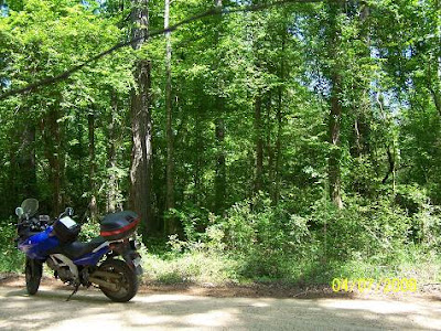
The GMO at La.36, west of Florenville, headed to Slidell and as close to the Pearl River as a line would want to be.


Here's the GMO at La.60. A powerline has used the Right Of Way of the defunct railroad. Next stop going west would have been Zona, and then on to Franklinton and and Tylertown.


Here are a couple of shots from Rio (rye-oh). That's the way the natives pronounce it. As I said, the town was named after station R-10. The natives saw R10 as Rio, not to be confused with rio, "river" in Spanish. No comment.


Mz Guzzi did not understand her location. I told her she was on a rail bed. She, no doubt thinking of a place to recline.

That is looking from Rio towards Bogalusa, just to keep you oriented.

South of Rio, the old bed is now a driveway.


West of Rio, out the branch line, the rails crossed Talley's Creek at Stein. I had a nice conversation with some friendly "older" fellas there. They told me the railroad would take folks to Flanklinton on the weekend to go shopping and, I guess, to have a day on the town, a movie, maybe. Franklinton is the parish seat of Washington Parish, a parish rich in forest from which the lumber industry prospered and for which these rails were laid. The parish fairgrounds houses one of the big GMO engines, well worth the ride. I was told that it was getting a face lift.


I was too late. I believe this is where the Rio station had been.


I have a bunch more, want to see them? Just kidding. I realize those pictures represent the source of the saying, "Well, I guess you needed to be there", to appreciate them. Being there in the sometimes very still quiet, does invoke the imagination. I have seen a flash of light that I knew was an engine coming at me from down a rail-less ROW. That was a moment. Those pictures also represent hours of fun exploring some archeology of a recently gone era. I never expected to find what I have near Sun, Louisiana. I wonder if the person who laid his driveway on the rail bed ever sees the lights or thinks about ghost trains? Not yet, or he'd have moved the driveway.

PS: There are GMO stations still in existence in Slidell and Tylertown. The Franklinton station is recently gone, a hardware store is now there. The Tylertown station is now a garden supply store. It is in a historic part of town on the south side, again, worth the ride.

On the next page, we'll look around Sun and down the "tracks". Coming soon.

Page 2

Last night, when I wrote the first page, I was on top of the world about finding the old engine. Then I made the mistake of contacting the person who had posted the list to tell him I found one and had pictures for him. He said he had a picture of it already and he knew right where it was. Period. That was it. He offered no praise or congratulations. I was crushed. :)Fred. When I offered my pictures, he said he'd like "some" of them. I looked to the North Star for guidance on which ones to send him. After receiving them all, he sent me some dumb form letter saying he had
posted..................none
posted.................none
And that these were on his site.

That was very personal.

Like I care. I was just trying to enhance his site.
What a twit. Is there something about old __arts with train websites? I've run into this pompous attitude before. Is it contagious? Gee, I hope not.
Sorry, I don't mean to slander the elderly, being one. He may be a young __art. But, honest, he smacked of old [like me]. Rant over, for a while.

Back to the story of finding the little engine that could no longer.
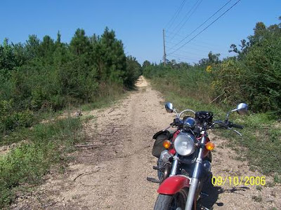
As I said, I was taking an afternoon break. The weather was perfect and it had been dry for a few days. I know one very fine dirt/gravel road that connects La.40 to La.437 just south of the Boga Chitto Bridge at Enon. Some of you oldsters might remember Enon as where the locals strung piano wire across the trails to surprise the enduro riders. Truth or rumor, who knows?

Here's my road, no piano wire.


Soon to be black berries lined the road. Snakes love black berries. I hate snakes.


Oh, for a true enduro motorbike.


The road then plunges into the Bogue Chitto backswamp where there is no telling what you will see. That actually goes for most of Southeast Louisiana. Hell, that goes for all of Louisiana. Then, there's Mississippi. Just be ready.


I parked and looked around. Now I'm parked and looking around for the rest of the swamp pictures.


Found it: ribbitt, ribbitt, croak.


I popped out on 437 and crossed the Bogue Chitto bridge, entering Enon where I turned east toward Sun.

There's a place along the way which features something very different, a split rail fence. I think of them as only being in the Appalachians and the east coast. Not. It seems they were where there were trees and no wire or wire was too expensive or hadn't been invented or...... Just a guess, I'm doing no research. Or, this modern day guy just wanted a split rail fence and made one. Whatever, here it is. I liked it so much I took 20 pictures. I don't abuse the North Star with petty decisions. That place is a loose end I've been meaning to take care of. This area will not be so accessible in the future. Pause for a sad moment.


Did I say that this is on La.16?


One more and then the stone house. Yes, we have a few rocks in La. I didn't know we had enough to build a house.


Not a bad page. What it does need is something red and another old barn.

Perfection:


Shortly, I entered Sun after carefully looking at every gravel pit along the way. Remember, I was looking for the old engine. I know it's been a while since I mentioned that, the rant and all.

Page 3

I'd done Sun, I thought. Actually, I'd done Mr. Bush. For those who know Mr.Bush, you'll understand I was pretty worn out by the time the 2 hour old tire tour was over. I was there doing an unabridged article on the Gulf Mobile and Ohio Railroad. I was really into trains until........ The article lost its lust and I flushed it.

This was a new day and I wasn't doing this ride with any academic pressure, and certainly not for any traineez.


This time I had a secret weapon, the topographic map. The topo shows old rail lines. It is a priceless addition. All I had to do was line myself up with the dashes.

I knew I was crossing the old rails. I would have anyway being that it was a hump in the road.


I decided to go south on Silica Street and see if there was anything more to see down there. It is a dead end that heads south riding besides the phantom rails. The same old stuff presented itself.


Then I stopped where I saw a clearing crossing the old bed. Mercy. I just had a horrible feeling that if I told you what I'd found, you would steal it, which was at first exactly what I thought of doing. So, I'm not.

I'll show you this since you can't steal it. There was a branch line off the main line. The rails are still in the road.


Look at the rails, not the bike.
There was another hint. There were two sets of rails, one of which I'd missed back in 2006. It's the little things that count. Look at the bottom right of the picture.


There is a creek between Silica Rd. and the main line. A bridge would be needed to cross it. I said, "Steve, look for the bridge".
Mercy, rotten railroad ties. I was getting giddy.


Below is hard to understand. It is the precipice of the bridge before the rails became suspended by the trestle.


I figured I'd done Silica Road, again, probably in a mistaken haste, again. I left looking at the pretty lake that inhabits one of the old gravel and sand pits.


I looked back north toward town and decided to check out the rails on the north side of La.16, what the heck?


That house sits right on the side of the tracks. I know it had something to do with the railroad.


I rode up the street that shadows the rails. A lady was sitting in her front yard which was very close to the street. I asked her......and the little dogs let out a fuss. No one could hear. She left and got her husband who joined me at the bike. He was very interested in the GPS but knew nothing of the engine. He did know where a trestle was. It was the continuation of his street. He pointed the way north. It was more than I could have imagined. The next five or six pictures are of it. You would have done the same, so stop moaning.


It crosses Wright's Creek, which follows the line south and is what the other trestle crossed when it had been intact.


I rode across the limestone covered trestle dragging my feet. I did not want to end up in Wright's Creek because of some unpredictable limestone, one of the worst riding surfaces you can be on.

Next, I headed south on La.21 looking for the engine.

Page 4


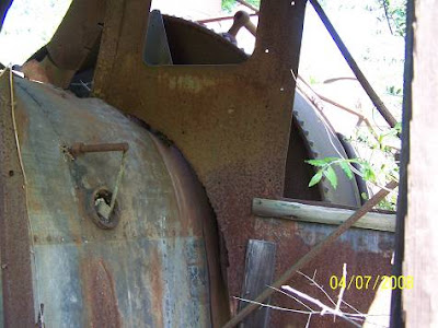
The engine was built in New Orleans for the Navy and sold to a local sand company. It is a small engine. Its number is 2653, the O-4-0 stands for the wheel layout, none in the front, 4 drivers and none under the cab. The ST part was a mystery to me. Steam Train would be too obvious.

Jim Tatum sent this, " You asked about the term ST in connection with the little 0-4-0. That means saddle tank - in other words, the locomotives water tank is over the boiler like a saddle. There was no tender on these tank engines, the water being in the saddle tank and....the guest book space ran out. It ran on standard gauge rails. I think. Looking at the boiler from the front of the engine, you can see the saddlebag shape.

I just like looking at the old engines, mostly. I must admit I like getting into them, also. The picture shows the engine's final demise. Those trees will tear it up.


That's the fire box and boiler. If I'm wrong, let me know.

Here's looking forward on the brakeman's side. (because the brake is there)


And out the front window:


That's the view the brakeman would see. Here's his brake.


And a sun roof, heat rises and letting it out is the thing to do.


That's it and I'm glad this one is over. The thrill is gone and a sense of sadness prevails over this page. No one in the area seems to care. Just keeping the small trees off of it would help preserve it. It is a bit of history lost.

Back to Slidell

I'd just finished a long ride down to Norco and I didn't want to head out on another biggie. I was not feeling creative so I decided to play one of my simple games of Find the Tracks. The GPS actually shows me where they are. It is my part to see if the roads which it says can get me to them, can. Usually, I fail because hunting clubs have seized many an old forest road that once was open. I decided that I'd see if I'd missed any chances at finding the old Gulf Mobile and Ohio bed from Hickory (La.36 near La.41) to Slidell (I-59,I-10 and I-12), Southeast Louisiana, USA. (we are internationally read, some in Texas)

The next pictures won't mean diddly to you. They are the few instances where I did commune with the old bed headed to Slidell. Garmin Topo is the software I use. It is old, so old it doesn't show many Interstates, but it does show historical, real historical, abandoned rail beds, grave yards, churches, trails, and a bunch of off the wall stuff.

Here's the bed as it crosses the flat coastal plain of southeast LA headed to Slidell which sits at the southeast corner of Lake Pontchartrain. I just uploaded a large map. The thumb is below, click on it. You can see how fruitless most of my attempts were. My tracks are the white dotted line. The rails can be seen angling down.


Here's the disappearing evidence.


I followed the tracks through town toward the station. The track crossing at US190 and US11 was under destruction/construction. I could not get across without fighting through gridlock. Finally, I got to the station and maneuvered to its rear where there is a park. What I saw was sad. The last remnants of the side track to the maintenance/storage area have been pulled up and I'm sure the bed will be leveled. I had originally thought, before the software, that it had been the old GMO/IC line north. No, like I said, it just went to a work area. Again, below is a thumb of a map. Click on it and look for "yard" and "station" down near where "SLIDELL" is written.


This is what the siding looked like a few years back. Very picturesque. It would have been perfect for a caboose or other rail car or engine. They blew it. Remember, this is a park. The exhibit could have rolled to the site.


Not so picturesque anymore.


Entrails lay about.
No spikes were to be seen. "Collectors"?

Here's the back of the station from a couple of angles.


Next, I decided to check out where the old GMO and later, Illinois Central, took off to the north. I could see the branch on the map. More horrible urban maneuvering was to be done. I could have walked it faster. It's located at the 190/11 intersection, viewable from the Rouses Grocery parking lot, where I'd been.


And here's the historic switch. I embellish.


Next, I went north from the parking lot to see if I could get to where the old west bound IC tracks branched from the north route. I first took this picture.
PS: the IC tracks (Illinois Central for those not well endowed in rail talk, such as myself) are now the Tammany Trace, a wonderful hiking and bicycling route. Very nice.


Seeing what looked like an arm of a "Y" (wye in rail talk), I zoomed out. I may have shot the south arm of the "Y" or a side track.


The wavy looking tracks denote that the camera was zoomed way way out (photographer talk).

I ain't claiming nothing, so hold the phone calls. If it's not the wye, make believe, I do. Life ain't that serious.

After doing what I could in that area, or at least doing what I thought I could, I headed back to the station for some frontal shots, just to make the article complete and maybe a little more spicy.


That's the best one. There was a lot of clutter, stop signs, cars and wires, etc.

There's a neat old building across the street. Let's call it a hotel though it probably wasn't.


Next, it was back to Road Wars. I wanted to find that old work area where the ripped rails had gone. This is what I found. I had to turn up the imagination to full.


I crept inside the fence, carefully positioning myself for a better picture. All at once the gate started closing. I'd be trapped inside. An Indiana Jones moment was upon me. I ran, jumped and rolled under the crushing barrier. Picking myself off the ground, I scrambled to the waiting bike and hit the starter, nothing, I hit it again and it roared to life. I slammed her into gear, the dern thing wheelied and I fell off the back, splitting my pants.

Next, while maintaining a rating of G sitting position uponst the motorcycle, I took a picture of these cute little houses that have been the witness to so much railroading.


Again, I was (still gracefully) sitting in traffic at the crossing when a parade of rr (railroad) tools began to roll by. They'd been working on the crossing and I guess they were headed to Motel Trainville for the night.


Here is one I lust for. It looks like a RV Coach. Man, how fun would that be!!!
Yes, and I'd like the orange one, please.


That was a good afternoon, if not a little sad and maddening and of course exciting and embarrassing. What you want, it was just an afternoon?

The next afternoon, after work, I headed back up to Rio or R 10. There I saw an old trestle and decided to ask the land owner if I could go on his property and shoot it. The treasure chest opened. This man knew stuff. He was a local historian and photographer. His aunt had painted the old station and adjoining country store. No, Frank, she's an artist, not a painter painter. I know what you were thinking. You'll have to wait until tomorrow for that.

Back to Rio (Nothing More at Rio) LOL's

I was out here just saying goodbye for a while or longer. I'd combed Rio looking for GM&O railroad evidence until the cows came home and they shewed me off. "Who's that nut", I'd hear reverberating from the piny woods. They'd be right about the classification of nut.

I'd ridden up from Sun after going to the lock and was going to make a loop home on 1074 from Rio on down to La.16 to Enon, then back to the high place to do the watch thing.

I crossed this little bridge knowing I was shadowing the old railroad bed. I saw the remains of a trestle. That railroad was torn up in 1978 or bouts so you do the math, I have a hard time doing that borrowing thing. In that time much has disappeared. Anything left has graduated to archeological heirloom status, yes, even old trestle pilings. To each his own.

I rode back and forth looking for a good angle for a shot. None was available. I was faced with a decision. I know you just want to look at the pictures, but you are going to have to wade through this first. I had to make a decision. Would I chance getting shot wandering onto another man's land, unfenced or not, or go to the house and ask him if I could take a picture and be again looked at like I was from outer space. I almost went for the chance to get shot and then backed off. That was a great decision. I had heard a 4 wheeler running so I knew someone was around and getting shot was looking likely. There was. I rolled up to Jim's house and he was outside. I told him who I was and asked him not to call the cops. I told him I wanted a shot of his trestle. Jim's about my age, sixtyish. He's lived there all his life and had ridden the train, heard the fast passenger trains pass and knew it all. He just talked and talked and then I asked if there had been a station, which I knew there had been since the town, previously called Jenkinsville was named R 10 or Rio for the station number. Jim's artist aunt had painted the station and a little country store that had been across the street. He also told me about the little school busses that rode on the rails. I forgot their name. Later. What should I show you next?

Ok, here's Jim's trestle. It was pretty much covered with vines but you can make it out. First I want to show you Jim's 1951 M37 Ammunition Carrier It's a Dodge I think he said.

Andy just wrote and said this, "Really liked that PC, Personnel Carrier, what we called them in the Marines. I worked on those things for about a year when in the motor pool. Tough as nails".

I knew I was wrong but the light seemed to say "ammo" to me. Jim gave me so much info on so much I forgot it all, almost. It runs but the battery is bad. It is complete with the red warning light. I remember that.
It's not pink, it's red. Don't get any ideas.


Cool, huh.

Ok, here's the trestle. It is over Sal's Branch, up above Wright's Creek that went through Sun. It's all starting to come together, huh?


This is taken, obviously, from on top. All that is missing is the rails and some other stuff, no doubt.

Here's looking back toward the main line and Jim's house.


These are his aunt's paintings. He gave me a bunch of railroad contact names and offered to take me to another trestle down the road that was real big and in a beautiful setting. Jim's brother was waiting for him and was none to happy he'd been escaping work on the farm by talking to me, so, I told him I'd just use his name as an introduction. It was getting too late to go barging in on someone at the dinner table so I'm saving that until later. Oh, Jim's older brother just got back from riding his bike to Alaska. He said he thought Canada was prettier.
All the news that is news, fair, balanced and unafraid.


And R 10.


I felt that my years of exploring the GMO had ended fruitfully. The sadness of seeing that beauty spot spoiled at the Slidell station had been erased by that little painting.

Next, I'm going to get that other trestle. It ain't over yet.

I never did, what a shame.