In the last week, or couple of weeks, Lowell and I have been exchanging information.
Dissecting our correspondences and translating them into something that might hold your interest is going to be a feat. Our enthusiasm may not translate and might come off, as my wife says, like water torture.
I like following trails, and then if the trail interests me enough I'll get into the history of the thing. I did that with the "Southwest of Iowa Junction" ride report. Lowell McManus read it and added quite a bit of information to the Lake Charles end of that ride and much more. This "article" is based on his notes to me and my interpretation. In some cases, if something sounds off, it's probably me.
Research is a treasure hunt. I can find the articles, but interpreting them without a dictionary of experience is impossible. Lowell added that ingredient to what I found and then added what he knew or found. Let's just say that Lake Charles is a bit torn up from all the digging we did.
The following will probably make you crazy and you'll run off after the first few paragraphs. No, problem, your loss. When I go to Lake Charles I'll know what went on where. If you want to use our X-ray vision glasses, follow along.
So it began:
I had done a new ride report on my travels which included shadowing the rails from Kinder to near Iowa Junction. Lowell was attending a meeting and requested that I hold my email until his return. When he got back I sent him the very long email written ride report. I do some reports on email as it is very fast and easy, not like this one.
In my note I said,
"I hadn't sent you this one because of your request. Since you have acknowledged your reappearance, here tiz. Of interest is the Fenton Depot which will take some scrolling to find.
And, I have a question. Did the Missouri Pacific operate the tracks between Iowa Junction into south Lake Charles? Thanks, Hope you had a good trip, Steve"
He wrote back, never short on information:
"The line from Alexandria to Lake Charles was built beginning circa 1887 as the Kansas City,
Watkins & Gulf. It belonged to a fellow named Watkins. Alexandria, not Kansas City was its northern terminus, and Watkins intended its southern terminus to be at a port city that he intended to build (and name after himself) on the east side of Calcasieu Lake just north of Cameron. He'd been aiming his railroad precisely at the future Watkins since before it left Rapides Parish. Then, a few miles south of Iowa, the plan changed (money?), and he suddenly diverted it to Lake Charles. In 1902, the KCW&G was reorganized as the StLW&G, seeming to choose a different Missouri city for its dreamed-of northern extension. In 1909, it was absorbed into the Saint Louis, Iron Mountain & Southern as a natural extension of that company's line down to Alexandria via Monroe. Both the StLIM&S and Missouri Pacific were controlled by the Gould heirs, and after the Goulds lost them, the successor management merged them in 1917".
At this point I'll introduce you to Mr.Watkins.

This was one of his trains.

This was his bank. It was Lake Charles' first.

Lowell mentions above that Watkins' railroad was absorbed into the "Iron Mountain" in 1909.
That prompted me to spout what little I knew of the Iron Mountain, connecting it with a write/report I'd done on the ferries across the Mississippi which resulted in him sending a load of information on that branch. He connected Little Rock, through Pine Bluff and Monroe to Alexandria as the main line which fed into the Iron Mountain's acquisition, Watkin's railroad which ran from Alexandria to the south side of Lake Charles.
That was the abridged part of that session. Since he knows so much I had to, at that time, show him what I knew which was unrelated. I don't like all of the conversation to be the other person's domain so this is what I shot at him, authoritatively, "I was exposed to the SLIM&S's existence when I was prowling around Ferriday and investigating the ferry at Vidalia. (the Packton to Ferriday and Vidalia to Ferriday Rides) Someone on the list sent me a picture of the bridge at Clayton that I had just missed seeing because it was torn down. That led to finding a report of a train going off into the Tensas there. Anyway, I started to wonder about it and Virgil mentioned there being another ferry further north. When I was checking out the ferries via a Trains Magazine article I came across one at Helena, Ar. The line served Clayton and now I'm understanding from you explanation it all connected up to south Lake Charles. Well it did sorta, that's when he set me straight about the main line from Little Rock to Alexandria.
I sent a map and suggested:

..... Here's the Tallulah branch of which you speak, I think. When I was following Grant I was riding all that area of NE La. You have to have a good imagination to keep you going because it sure is flat and boring country. I've often thought about hitting all the old river towns just to see what is left".
Lowell patiently replied:
"You've got the map about right, except that the upper ferry might have been at Arkansas City, rather than Helena (although it could have been in different places at different times, due perhaps to changes in the river). Attached are Louisiana and Arkansas rail maps from 1916 and a Louisiana map dated 1895. Take this last one with a grain of salt. It shows some lines that were planned then but not built until later, so it might show some that were planned but never built".
"The Iron Mountain line to Ferriday connected with the one to Alexandria and Lake Charles no farther south than Collinston in Morehouse Parish. The Iron Mountain line that the acquisition of the Watkins extended to Lake Charles was the one from Little Rock through Pine Bluff, and Monroe to Alexandria".
I didn't mention Ferriday again.
Here are 2 of the priceless SUPER LARGE MAPS FOR YOU TO DOWNLOAD. Click them, wait for them to appear and download them.
Arkansas

Louisiana

On 6/18/2011 12:29 AM, Lowell G. McManus wrote:
Steve,
"The StLIM&S had a system of lines all down through Missouri, Arkansas, and Louisiana. Its main line was from St. Louis through Little Rock to Texarkana. A main branch was the now-existing UP line from Little Rock through Monroe to Alexandria and (with the acquisition of the Watkins) to Lake Charles. There were lesser branches all over northeastern Louisiana, like the two that went to Ferriday (from Tallulah and Bastrop, respectively). A line from Ferriday went to Vidalia and ferried across the river to Natchez. These all became MP in due time. Most are gone now".
We are now done with the preliminary small talk about the Iron Mountain above Alexandria which only pertains to what is to follow a tiny bit.
Entering Lake Charles from Iowa Junction
Lowell contributed this transitional paragraph that moved us along:
Steve,
"You might notice a southward curve in modern maps of the ex-Watkins UP line into Lake Charles that's not there on old maps. I refer to a point west of the sudden westward turn south of Iowa. That southward deviation was installed at some time unknown to me to accommodate the length of the runway at the now Chennault International Airport back when it was the Lake Charles AFB or the later Chennault AFB".
Lowell G. McManus
Texas, USA
In a knee jerk I had another "Mr. Cartah, Mr. Cartah" moment and chimed in. He was now on my stomping grounds and I was completely aware of what he was talking.
Me, keeping it simple this time, "That is noted in the "Southwest of Iowa Junction" RR (ride report)" and thanks for the maps. I love maps. It also makes me very happy to be familiar with what you are talking about. I had to check out the Iowa to Lake Charles and into Lake Charles rails. It took several rides over there and that write is HERE".
In the map below, taken from the "Southwest of Iowa Junction" write, the green line is the Watkins route coming in from Iowa Junction. You can see the airport protruding across the original ROW. Purple is what exists today. Now we both have you into eastern Lake Charles.
Since you are here we'll go ahead and tell you that the Iron Mountain/ Missouri
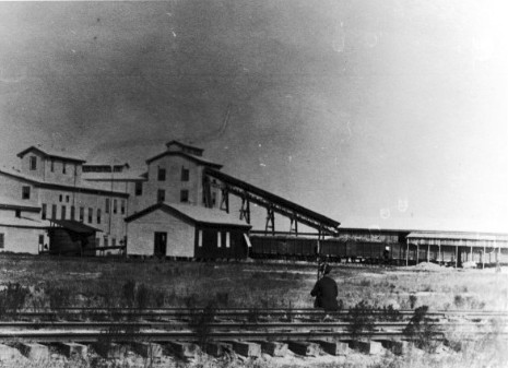
Pacific had a car shop about where you see the Mallard Cove Golf Course.

This was the car shop. Were those separate rail doors for work bays?

I suggested that my SW of Iowa Junction ride report was very long and that maybe he should wait for a rainy day which was of course a joke since he lives in south Texas and it never rains, at least this time of year. {As soon as I wrote that he e-mailed me that it had rained 2 inches. It never fails}
Later he responded:
"I have plowed through the Lake Charles segments of the ride report that you linked. (I decided not to wait for a rainy day, because it might be a very long wait. It's 112° right now, with virtually non-existent humidity and gusty wind. It makes your eyeballs hurt from the dryness the moment you walk out into it and face the wind.)"
That was very kind of him to give his "eye ball hurting" an alternate cause. In reality the pain was probably due them doing all that "plowing" through my rather long and ..... prose. Hey, I'll take kindness where I can find it.
Another Mr. Cartah moment hit and I added that I'd found something north of the east-west main La. Western/ SP line {Interstate 10} that might interest him, "I know that there was a 'hook' at the top of the 1st St. branch which came up from the Missouri Pacific (running east-west in south Lake Charles) and ran across the Southern Pacific, and connected to the SP, previously the Louisiana & Pacific, at the Calcasieu River. "
It's time for a map. But this one is too complete for now so I'll just tell you a few colors.
Dark blue at the bottom is Watkin's railroad, ie, the Iron Mountain, ie, the Missouri Pacific.
The orange line is what Lowell diagnosed as the MP branch going north to the port facilities on the upper Calcasieu River, which got there by way of my "hook" to the west. The continuation of the blue line rails on the south side of the map would yield more intrigue.
This is Lowell's map based on some of my findings.

Let's enjoy "the hook" for a moment. I don't contribute much, but when I do I like to celebrate for a moment. Below is a picture taken during the "Red Sand Hill Railroad" ride. I had no idea where the rails that the road crossed (below) had come from and blew it off as I didn't have time to investigate them at the time. The Lake Charles portion of the Southwest of Iowa Junction ride and further research and map study along with Google Earth sessions, gave me the big grins, big time. Lowell produced another ancient map that supported my thesis. That bugger is for you in a while. If I showed it to you now, you'd never come back but sit there staring and trying to read all the tiny print, like I have.
Here's the picture from "Red Sand Hill RR":

That crossing was above where you see "Yard" on the map below. It
is the black flag marked "CR1", as it was the first crossing I'd found.
This exploration was centered on the Louisiana Western/SP
rails north of I-10 and the SP DeRidder Branch which had
a very interesting history. Lowell has added large quantities
of info to that read if you get in the mood. First you have to
do this one.
There were wharfs along the Calcasieu River.
There was a lumber mill and I do believe a rice mill.
We believe that each of the 3 railroads in Lake Charles served
that area. You try to figure out who owned what. A hint is
this, the main e/w line above where you see"90" is SP.
The line above it is KCS to the west. What goes north is my scribbling.
Tell ya what, blow off the blue line. It will only confuse you,
but not as much as the green line will. That was me in LC.

In an epiphenomena and Shakespearean moment, Lowell wrote:
"Methinks that it would suffice to say that SP, KCS, and MP all had a maze of spurs into that old north port area to serve various customers".
While here, near the SP Calcasieu River crossing, I'll show
you the bridge which is still there, I believe. At least the
one I shot doesn't look much different. Water sure is high.
There were 2 bridges, one belonging to the Southern Pacific
and the other belonging to the Kansas City Southern. Which
one this is I can't say.

During the SW of Iowa Jct. trip I went back and did as much of inner Lake Charles as I could. Remember my round trip commute is 180 miles. I do the "go and search" full bore and worry about the "get back" when the time comes. I wish I had had a notion of what railroad was what railroad in the inner city. By the way, rail searching in Lake Charles is a no stress deal south of I 10. I did feel a little stress north of I-10.
Evidently I had expressed my remorse about not knowing who was who to Lowell or he read my mind. He responded, either way:
"I remember the 1st Avenue line that connected the MP line across the south part of town with the SP line across the north, but I never knew to which company it belonged. I now suppose that it must have been MP. I agree with your findings of a westward hook on its north end to access the industrial/port area on that segment of the river that's north of downtown. Since that area was also accessed by SP via the De Ridder branch, the 1st Avenue line seems to have been MP's. That port area up there {above I-10} has declined so much in importance that the long-awaited I 10 replacement bridge over the Calcasieu River will be much lower than the old one".
While we are here I'll show you a picture of the rice mill I think was one of the river industries.

I just found it on Lowell's map. I have not run this by him yet.
But, as I see it, the yellow line is my "hook" coming up from
the MP in south Lake Charles which ran along 12th St.
The red line I completely believe to be the Southern Pacific's
link to the north port. The line would continue north to De Ridder
and the lumber mills. You can see the words, "Rice Milling".

This is a local sugar mill. I'm not sure of the location.
Investigating that earlier ride I found a rant by a local citizen on how Lake Charles had destroyed its past. The writer mentioned that all the wharfs that had been destroyed and down town made impossible to maneuver. I sent it to Lowell. It presented a vision of the town whose rails we were following.
Lowell's comment first: "I had read your quotes of Mr. Cormier's rant and your De Ridder Branch report yesterday. More a bit later on some of my theories of the succession of rail lines. I've found an old city map that might be helpful".
This was the first mention of the map. Now to the rant:
The writer bemoaned, "1960/1970 Ryan Street was the commercial and business hub of the area with continuous storefronts from Mill Street to Clarence Street. {both important in our rail research} There were department stores, specialty shops, diners, theatres, drugstores, professional offices, hotels and government offices in a concentrated area downtown from Front Street (now Lakeshore Drive) to Hodges Street. In the early 30's, Ryan had supplanted Railroad Avenue (once known as Battle Row) as the principal commercial street. {This street paralleled the Southern Pacific} In Sulphur, Huntington and Napoleon served the same purposes. Each town had its urban core. As the 50's slid into the 60's and 70's, the growth of the automobile culture began erosion of the urban core. "
"In Lake Charles they tore down the Calcasieu State Bank to build nothing. They tore down the Majestic Hotel (which housed every president from Teddy Roosevelt to John F Kennedy) to build nothing. They tore down the Paramount Theatre, a real movie palace, to build nothing. They tore down the Elks Home, the Weber Building, the Kress Building and Woolworth Building to build nothing. They tore down the Missouri Central Station; they tore down the Kansas City Southern Station. The Arcade Theatre (where Houdini amazed the locals, and where the St Louis Symphony played to sellout crowds) caught fire and then they tore it down. The Southern Pacific Station was torched, then they tore it down. And while they were tearing down most of our visual history, they ripped up the wharves and warehouses on the lake and filled in 64 acres of lake and built 40 acres of parking lots and a marginally attractive Civic Center. And they blocked the major north south road to construct a pedestrian mall and produced a maze of one way streets to nowhere that virtually killed down town Lake Charles".
Lowell expressed that a depot location was missing, the one we needed in our MP and priors search. I knew where to find it. I was so proud when I sent him this, "As far as the locations of the stations go, "The Federal Writers Project, LA", should have a listing of the locations of the stations. It does for Opelousas. Of course it was done in the late 30's and early 40's".

The MP depot was near Ryan and Clarence and occupied a large lot.
Below is the old Southern Pacific Passenger and Freight
Depot on Railroad Ave. between Kirkman and Reid Sts.
It was built in 1880 and torn down in 1899. Notice the
Wells Fargo Express wagon and slaughtered pigs awaiting
delivery.

Below are the locations of the other 2 depots.

Lowell continues:
"After the UP+SP merger, the stub of the SP Lake Arthur line from Mallard Junction to the southeast corner of Chennault was chosen to replace both the 1st Avenue line and the part of the old Watkins/StLIM&S between Chennault and Iowa Junction {the old Watkins line} to tie everything together".
Map below if you forgot.
"What is entirely new to me in your findings is the existence of your red (map above the map above) "Wharf Branch." Kudos to you for locating it!"
At that point I felt very important but all I'd done was to look at my old Topo Map and trace it. No snakes were involved, no wild threatening natives, no mud, nothing but my wife, occasionally.
He then stated that, "The topos do indeed show it, and the satellite pictures make obvious its route from the 12th/Sallier Street line, {the east west rails) up Common Street {in the middle of the street} to above 6th Street, then along the north bank of that ditch (Pithon Coulee {running east-west}) to Lakeshore Drive. You probably know that all of the Civic Center premises west of Lakeshore Drive from there up to Broad Street is artificial land fill. {no I didn't or hadn't thought about it lately} I don't know what kinds of wharfs there might have been there, but the topos do show a track along the old lake shore, perhaps in what is now the southbound lanes of Lakeshore Drive. (I had felt their presence as I rode along) Follow the "Wharf Branch" north to its crossing with Lawrence Street, and that's also where it crossed the KCS. It appears that the KCS crossed the "Wharf Branch," Lawrence Street, and the former Front Street all at the same place."
Below, that is pretty clear.
Here's my concept:
The yellow shows KCS facilities. The red is the "Wharf Branch." The magenta is the Sunset Route (SP). That the line toward the northeast corner of the sat pic is KCS's is an assumption, based on the facts that SP and MP apparently had their own lines into the old port/industrial area along the river to the north.

He continues:
"Now get this: My April 1961 Travelers Railway Guide shows in its station index that there were three stations in Lake Charles. KCS had one. A second was served by both Lake Charles & Northern and Louisiana & Western. StLIM&S had the third. We know where the KCS and SP stations were, but this begs the question where the Iron Mountain station was. It might have been near downtown on your "Wharf Branch."
{The Federal Writers book confirmed his placement}
Between Clarence and Ryan Sts. was the Missouri Pacific station.
Now, here's a close-up of Lake Charles on the 1914 map of the Railroad Commission of Louisiana:

Note that the Iron Mountain coming in from Iowa Junction crosses the SP Lake Arthur line at Lacasine Crossing. This would be at the location of Mud Supply on the map below".
"It's 2¼ miles from there to "Car Shops," so we know that the Iron Mountain had car shops there".
The Car Shops (again)

"This distance would put the shops between the golf course and I-210. (So now you know where I got that information) Two miles farther west is "Lake Spur, Jc." That is exactly the distance to the 1st Avenue line". To save you looking back I'll repeat the map".
"Next, a short distance west of there is "Mill Spur Jc." with no distance shown. It's about .7 mile from the 1st Avenue line to the point where the line that goes on westward {to} your "Wharf Branch" split. It's not clear which of these is the main line and which is the Mill Spur".
I'll interject here. I think we found the main line to be "Lake Spur" an Mill Spur to be possibly to a sugar mill with a small yard at the lake. Yes, he's going to yell at me I know it as the sugarcane guess is pure speculation. It doesn't sound likely a sugar mill would be so far from the fields.
This is what he found. It's WATKINS STREET, a sure sign
that either a railroad or bank was near.
Tip: Dr. Michael Debakey Dr is the former Ryan St.
Red is the small yard he asked me if I saw.

He continues:
"Let's examine the terminus of that westward line toward the lake (before there was the modern line to the "new" port): There are pavement patches where this line crossed Sallier, 11th, and Elms Streets".
I remember seeing them. I do!! I do!!
He asked, "Had you found the yard? It's not very big".
My reply based on my recollection of the whole ordeal was: You ask if I'd found a little yard. Frankly, Lowell, I was on a bike in traffic and mostly watching out for my tail on a rushed visit. It's a wonder I found my way home or made it home".
I suppose I snapped at him now that I review my response. I think it was born of jealousy. He can find stuff using satellites whereas I have to blindly plod all over the place.
But I did temper it with: More tomorrow. Glad you ditched the rainy day scheduling on reading my report. That Watkins street find {where the tracks reached to the port} is the bomb. Gotta quit before I get too stupid. (I knew in my heart it was too late for that statement).
Lowell would push on with the Watkins St. branch (with the little yard) and my Wharf Branch.
"Note that the topo shows a split into two tracks there. There's also a track shown that crosses Dr. Michael Debakey Drive (formerly Ryan Street) and ends about where my yellow arrow (above) is by Watkins Street. I didn't show that on the sat pic above because I don't find any evidence of it left, but that's a modern subdivision now".

Me: Yes, but we know it was there.
L: "This is enough for tonight. I've been writing this piecemeal since afternoon. It's 102° at 9:30 p.m".
Agent 00-L
Texas, USA
Don't ask me to explain the "Agent 00-L" deal, he'd have to kill me.
One more picture.
Below: Ignore the yellow line. I put it there to irritate OO-L
The yard Lowell found is southeast of Debackey. He told
me to make sure to mention that I found the second yard
near the river. I actually think he did but I'm not telling him that.
As you can see above, the rails went to the water.
We sure would like to know why. If you know, please write.
I know there are some Lake Charles readers out there.

Lowell, graciously said, "I think that the yellow line on your map below, connecting the end of the line at Watkins Street with the "Wharf Branch" at the mouth of Pithon Coulee is a bit too speculative".
I conceded: Yes, the yellow line would make the other route senseless unless there was some industry involved on the lower Wharf Branch.
Then there was a break in the action as Lowell mulled over and plowed through this, "Lane's Thesis". "INDUSTRIAL DEVELOPMENT OF LAKE CHARLES, LOUISIANA 1920-1950" by Bernard H. Lane
Then I got a brief note:
"More a bit later on some of my theories of the succession of rail lines. I've found an old city map that might be helpful".
Then I got a brief note:
"More a bit later on some of my theories of the succession of rail lines. I've found an old city map that might be helpful".
The silence continued into the evening. I thought he'd gone hunting so I sent this in hopes of rekindling any fire that might still be flickering.
Me: As I remember, most visible spurs came off the same main line. Maybe they had a joint service line and all fed to it and then had their individual spurs. Maybe, the city (port authority) supplied the main access line. Now there a reach, but one of those pictures from La Digital Library mentions a Belt Line. I wasn't sure it was at LC but the credits said Lake Charles. Again very speculative and sketchy info.
Then I got this:
On 6/19/2011 2:32 PM, Lowell G. McManus wrote:
Steve,
I've found the Belt Line and am writing it up right now. Be patient.
After reading Lane's write, the flow started slowly, then stopped which was my fault. I should have never....
Lowell's next message, "This fellow's masters thesis is very interesting, but I can't help but want to draw a big red circle around every time he spells Vermilion as "Vermillion"!
That sidetracked things for 6 hours as we argued about the spelling of Vermillion (Lowell, my spell check just accepted "ll". Don't even ask about the blaze of retaliatory links and examples that followed or what I will probably receive for reviving this argument.
After the initial disdain I sensed he had for Mr. Lane and his "ll's", Lowell seemed to take a liking to the fellow because of what he pointed out next:
"{The author} writes on the sixth paragraph of Chapter II: Among other settlers who came during this period [early 1800's] were Reese Perkins, the first justice of the peace. It has been said that his courts were administered with more backwoods justice than with statutory law... This Reese Perkins was a brother to my great great great great great grandmother Jane Perkins Smart. I'm distantly kin to many of the oldest Anglo families of Lake Charles".
I clearly saw the link between the "administration of backwoods law" and the wrath that was administered to Mr. Lane's spelling of Vermillion. (no spell check again!!)
Alright, enough fun and games, back to the serious. I knew I was working with a fellow that knew a lot of history. What I hadn't caught onto in our years corresponding, is his ability to analyze historical situations. I may have alluded to this further up the page and if so, it is the following that spawned that. OK, latch your seat belts and hang on for a large dose of deductive logic.
"The most significant thing that I learned from this thesis {Lane's} is that the port was not developed until the ship channels were dredged in 1924. Before that, the only meaningful navigation traffic (or need for wharves) would have been for sailing schooners in the coastwise and Mexican trade. However, the coming of the railroad (SP in 1880) immediately killed off the schooner trade. Thus, there would have been a black hole in the maritime history and importance of Lake Charles between 1880 and 1924. I will revisit this void in a message to follow".
"Here's his map of Lake Charles, produced by the city in 1895".
This is the Holly Grail. Click it and download.

Lowell continues. In his explanation he summarizes much of what is above:
"Unfortunately, this is the highest resolution available. Still, it's pretty good. Observations: This is clearly a later printing of the 1895 map with some post-1895 revisions. I say this because the KCS line is shown as such. It did not exist until 1897, and was not KCS until 1900. Still, this map is probably not much later than that. Note that it shows the lines to the Bradley-Ramsey sawmill at Goosport, but it does not show the 1906 De Ridder line running northward from there. First, let's concentrate on the Watkins. The map shows the "Kansas City, Watkins & Gulf R.R." along the 12th Street corridor across the southern edge of the city. It curves north toward its western end, goes right on across Dr. Michael Debakey Drive (minus the little yard there that I discovered last night), runs alongside Watkins Street, and terminates in two tracks on the lake shore. I wish I could read the fine print at that point. Anyway, that terminus must have been the original focus of the Watkins in Lake Charles".
Next is the good stuff:
"Note that this map is dated during the 1880-1924 doughnut hole in middle of Lake Charles's maritime history. This probably explains why much of your "Wharf Branch" is missing from this map. It must have been built later--I theorize after the 1924 opening of the ship channels and the need for new wharves along the lake front for ocean-going steamers. Note also that the connections to the old north port that later wyed off the curve from the KCS bridge are also missing. However, the 1914 Railroad Commission map shows an intermediate junction, presumably for the track that turns off the then StLIM&S and runs up the Common Street and Pithon Coulee corridor to where we know the MP had its depot. This spur might have been built this far (or a bit farther to the lake shore at the mouth of Pithon Coulee), perhaps with the addition of the new depot closer to downtown, by 1914".
Now, to the Belt Line I'd seen in the picture. Lowell continues: Note on the map how the line in the 1st Avenue corridor is shown. It appears to say "1st AVE." and "BELT LINE" not far north of where it turns out of the Watkins {MP ROW}. It runs up 1st Avenue all the way to the western hook north of the SP and even on toward the mill at Goosport. Significantly, note that a line also turns out of the Watkins and runs up Enterprise Boulevard, just one block west of and parallel to 1st Avenue. These two lines are shown as dashed, but so is the SP in the eastern part of the map. I don't know what that means, but it doesn't make me believe less in the lines' existence. Both the 1st and the Enterprise lines curve into Broad Street and run in it to the lake front. The 1st Avenue line has a full wye at Broad.
Broad to the river is Blue.
1st St. is Red (the MP line we believe)
Enterprise St. is Green.

One more:
Red is the "Wharf Branch".
Green is Broad St.
Blue is 1st St. and the "Hook" to the rice mill.
Gray is Enterprise St.
Blue line along the bottom is 12th St.
Gray line going north is the SP/Louisiana and Pacific/ Lake Charles and Northern.
He continues:
"To this day, the median of Enterprise is much wider south of Broad than it is north of Broad. We know that the track was in the median of 1st Avenue until a few years ago, and that median still remains bare. The median of Enterprise, however, is now occupied by large trees, proving that any track there was removed long ago".
"Photo captions from the LOUIS web site say, "The Belt Line Railway Train traveled down Broad St. to the lake front and then made its way to the car shops. The last stop {on the north end} was to pick up Mill employes at the Bradley-Ramsay mill," and "'The Dummy' - that ran from the foot of Broad street - out to the machine shop of the Watkins Railroad".
A Belt Line train at the car/machine shop.

The Dummy, possibly with students.

Later the Dummy was used to bring pupils back and forth from the High School. The scene above - in the late 90's, is on Broad street." On this map, just before the track in Broad Street reaches the lake front, it turns north and assumes the exact alignment that I drew in red last night on a sat pic (running along the east side of the KCS yard under I 10 and curving eastward into the SP).
So, your "Wharf Branch" was built in at least three segments. According to this map, the northern segment (SP to Broad) was already in place circa 1900, but the rest was not. The southern segment (StLIM&S to near the mouth of Pithon Coulee) was probably in place by 1914. The middle segment that connected them would have been unneeded prior to the 1924 maritime renaissance that brought wharves to the lake front, where the Civic Center land fill is now. A 1926 photo of the port in LOUIS shows tracks. After that last connection along the lake front was there, it would have made sense to remove the track from Broad Street, and a 1927 photo of Broad in LOUIS shows no tracks. (Note that the tracks in several photos of Ryan Street downtown are street car tracks.) This scenario of construction of the "Wharf Branch" in segments suggests that at least some segments belonged to different railways. They could have combined them into a joint track operation to allow more than one to switch the wharves".
Take a deep breath.
I kept after him since I had his attention. You never know when the government might call him away. (oops, don't tell him I said that!)
I must interject. While listening to the radio a distress call was made from an engine. The toilet was overflowing. The dispatcher was overheard referring to it as the "Poop train" and that he had to make a "Can Report". Later it was determined that the toilet had not been emptied during the last servicing. Makes you wonder what else was skipped.
Back to my next question I had for Lowell:
"In doing some research for Red Sand Hill RR ride I found another name for the RR going north. I had this thought. It concerns a is a place labeled as Bridge Junction. The railroad had at one time had the name "Lake Charles and Navigation Railroad". Had it ferried cars? Had it ferried them here?"
His reply:
Steve, Notice my relatives' ferry on the left end of your map. :-)
Lowell: "I think that the author of your quotation (that was me) has his wires crossed and has conflated two different railways".
Yes I had.
He replies: "The index of the 1914 Railroad Commission map lists two separate railroads as follows:
Lake Charles & Northern Railroad Co.
Lake Charles Railway & Navigation Co.
You know what and where the former is. {Yes, I followed the dern thing from stem to stern} The latter is explained HERE . It's line is shown on the 1914 Railroad Commission map exactly as described in this link.
Next was this, I think. It sure was a pick me up from my resent conflated railroad statement.
"Steve. I've never known the details of the history of this line between Lake Charles and De Ridder. I've always just considered it what it was when it finally fizzled, and that was the SP De Ridder Branch. However, I have recently read a treatise on its history by a fellow who called it the Red Sand Hill Railroad. That scholar quotes sources saying that it was started by Bradley-Ramsey as the Lake Charles & Leesville between Goos Bay and Bannister. Then, Bradley-Ramsey was bought out by Long-Bel, and that included the rails. Long-Bel appears to have extended them to De Ridder to serve it's large new mill at Longville and the others that it already owned or would buy along the route. Presumably, that's when it became the Louisiana & Pacific. Then, says the aforementioned scholar, Long-Bel sold the track to the [SP-owned] Lake Charles & Northern. However, Long-Bel retained trackage rights for its L&P logging trains".
Update: Going forward I will be known as "That Scholar" or the "Aforementioned Scholar" who just spelled scholar wrong.
See HERE for more on the distinction between L&P and LC&N.
Lowell continues, "All of this ICC "tap line case" stuff is very complex. Below is a simplification at the risk of over-simplifying. Beside that, I'm not an expert on this topic, so I might have some of the details a little off. For that reason, please don't quote me on this".
In the following, the absence of quotations denotes that Lowell did not say this. Lowell has left the building.
I found this written on a wall somewhere.
When a rail shipment travels over more than one railway in its trip, the railways involved split the revenues, roughly according to mileage on each. Railways bean-counters call these splits "divisions." However, the originating line and the terminating line get "allowances" above what their mileages would justify. This incentivizes the originating line for winning the business and compensates both for the additional costs of orchestrating the pick-up and deliveries.
"Now, consider that a sawmill owns its own rails, maybe even for miles, to reach the real railroad. The fact that the sawmill gives its line a railroady-sounding name (such as one ending in "Pacific") doesn't necessarily mean that the sawmill's line is anything more than glorified private plant trackage. The question always arose whether the sawmill's "tap line" was a real enough railroad to deserve divisions and, especially, allowances. Even if it hauled logs many miles from the woods to the mill for its owner (and typically never charged a cent for doing so and had no other customers), did it really deserve allowances for switching cars of its owner's finished lumber 200 feet from the sawmill to the real line-haul railroad? Some line-haul railways would go along with the pretense and give allowances that were nothing more than kickbacks to get the sawmill to ship with it rather than another railway; but other line-haul railways involved in the route complained that such allowances diminished their divisions. The ICC usually had to sort these things out, deciding who was a real railroad and who wasn't, etc., etc. Well, you get the picture".
In the current topic, we see Long-Bell sell its L&P track to SP but keep the right to run its own trains over it. This was very likely a ploy to get around some of these issues. I can't exactly explain all the detailed considerations, but, again, you can see something of how it might have happened.
Hope you can too and if you don't find this article completely coherent, it's not Lowell's fault, it's the Aforementioned Scholar's doing.
Thanks to Lowell McManus for all his hard work in trying to edumicate all us-ins.
And thanks Lowell for being goodnatured (a Southern word like Vermillion) sport through all this page. If you didn't assassinate me somewhere up the page I guess I'm safe.
Here's another map for y'all's collections. Don't say I never gave you nothing.

There is more:
More investigation and thought on whether the bridge in the old shot is the KCS or SP bridge across the Calcasieu River at Lake Charles/Sulfur and MORE from Lowell:
Steve,
On further examination, I think that your photo is of the SP bridge.
The photo shows that it has three trusses, and the bridge currently has two. This aerial photo will show that the third eastern truss has been replaced by what is now a concrete trestle:

The old photo:


I don't believe that the bridge has been shortened, other than the replacement of the eastern truss with a trestle. Study the sat pics, and you will see that the bridge crosses the river between two natural river banks, and it has a long fill across the northern lobe of the lake. That fill has a trestle section near its eastern end. Understand that the land south of there, in the vicinity of the east end of the I 10 bridge and probably as far east as the east end of the beach is artificial landfill. Compare the shape of the north shore of the lake between the modern sat pics and the 1895 city map that I sent you.
My theory was that the bridge was put where it was because a long fill approach was going to be needed on the east side, and one could be dumped from barges on the lake more easily than hauled in on swampy land. The builders of the later KCS bridge had no choice but to use the latter method. Notice the configuration of its fill and trestle segments on the sat pics. That slightly crooked line through the swamp a bit north of the former KCS bridge is a power line right-of-way.
I have just found a looooong history of Lake Charles at http://library.mcneese.edu/depts/archive/ftbooks/haupt%20port.htm , but I see that's apparently where you found the bridge photo. This has the most thorough info yet on J. B. Watkins. Did you see that it says that he "built and operated a sugar refinery east of Lake Charles near the site that is now the Chennault International Airport"? He must have owned lots of land out that way.
It also says that he "built the first street railway system (the Steam Dummy Line) which ran north on Watkins [now Enterprise] Boulevard, then turned west on Broad Street to the lake." So, we now know for sure that the Dummy was his. This probably explains the double parallel lines on Enterprise and 1st. Enterprise was the ritziest residential street, and perhaps where Watkins himself lived. (After all, it was the street that bore his name.) The Dummy was needed for transport to downtown, schools, etc., but the classy residents wouldn't have wanted freight trains to and from the upriver sawmills and rice mill to run the median of their street.
Lowell G. McManus
Texas, USA
Texas, USA