seems to be the end of the local district for the BNSF
office. Warrants end there. Another dispatcher office
picks up the trains going west. This is what is left
of the famous junction. The red arrow points to the
original cross track, I'll bet. I found the remaining evidence
of the rails south of the junction. This ride report is
about following that evidence. Click the pictures for a
little larger version.


Southwest of Iowa Junction
Feeling like I was worn out with the whole "chase a choo choo" scene, I mulled about thinking about what was next, or if there was a "next". Maybe I should just sell the bikes and be done with it, possibly get a skiff and and row about instead of worrying about old rail ROWs. The day, a March Monday dawned gray, chilly and unsettled. The weather guy said something about a cold front coming and going leading me to think that a stormy day was in the offing. If you sign up with these guys you are lost, ruled by a local TV "personality". Turn them off and just do what you want to do. Sermon over, but that's the way it is. If I'd stayed huddled in the corner, waiting for the thunder, I'd never found what was southwest of Iowa Junction.
Instead of posting maps at the correct, in sequence locations, I'm going to post them all right now. I know what people download from my site and "maps" are the top of the list. I love maps, they are the key to not only the imagination, but also, reality. Whoever came up with the idea of "maps" was indeed brilliant. Now's the time to download them, put them on the side and you'll be in sync with this story of discovery. These are large maps. What you see here are icons for those maps. Click them and download what you see next. This story is about following US 90 west from Lafayette to Iowa (LA) and then the good part starts. Alright, I'll give you a few minutes before we dive in.
I started this ride at the Lafayette Railroad Yard. BTW, if you want to bypass that endless light at Ambassador Caffery, take my route. I don't ride it only for its scenic value.


Done yet? Got them all lined up in a folder where you can
click along? Tee He, "click along", that's punish.
Oops, one is missing, but I fixed you up further down the page.
Sitting in the starting gate was a huge snake of a train.
I knew he had waited until the Limited had cleared going
south.

From the Pecan Grove crossing, I got a shot of the Black Stallion
kicking to go.

Just west of the yard is Scott, La, "Where the West Begins".
Scott seems to have adopted a RR theme. This bar is cutely
named Kross Ties Tavern.

Here are a few immediately available shots of old places.


This was a fine old Scott bar. It was a Plain Jane until
someone got the idea to make it a Southern Pacific depot.
I'm telling ya, Scott is on track to up its tourist business.
Good for them. I kinda liked the old bar and hate to see
history tweaked and lies created, but it's better than tearing
it down.

This is where the real depot was.

I parked in its parking lot. The azaleas are gorgeous this year.

This building is across the street. I can't place the era.
Possibly it belongs to the Early Modern Age, about the
time I got built.

Next, I was on to Duson. Duson is dwarfed by its water tower.
It can be seen for miles. I was glad to see it on the way home.

Duson was named for a couple of brothers that helped
promote the area to the railroad, I think the story goes.
They also promoted themselves into successful business men.

This old building has been intriguing to me for a long time.
I finally got a good shot of the sign on its side.


Oh help me. Is it the supplier for those enemas you have
to have before a certain medical procedure is conducted?
Click it and find out.

The next interesting site was this one. CLICK HERE
to learn more. Later I saw black parishioners filing in,
which after you read the info, makes sense.

Next, 90 stretches out next to the tracks west of Duson.
The great thing about riding 90 is that at any time you
might get to see a choo choo.

In the past I've tried to show touristy shots of Rayne.
This time, this one is unfiltered.

I know a special way through town. Road level ponds
will dominate the landscape from here west. Crawfish
and rice are their products.

Right when I rejoined US 90 I heard the train I'd seen at
the yard. I went to my private viewing area. It never came.


I was on to Crowley. BTW, I love Crowley. Seriously, it is
a great place. The area around the tracks should be
grouped as a national historic site. I've heard the rest of
the town ain't bad either as a Victorian architectural showcase.
But, alas, the big corrugated steel buildings are my taste.

Louisiana. There is nowhere like Louisiana. It cannot be replicated.

I was at the old depot site. On the return ride I saw these
boys using the freight platform for skateboarding.

You don't come to Crowley w/o taking a shot of the old depot.
Sadly, its condition is worsening. Some windows are
boarded up, shamefully.

This is not shameful. Someone did a wonderful job of
restoring this little house. The colors say "railroad", but it
was moved in, from where? The owner must love the
tracks as it would take devotion to live in this spot. This
shot was taken from beneath the La.13 rail overpass bridge.
Noise from the bridge and noise from the tracks come
with the territory.

More mill pictures. It's an addiction.

I caught a classic today, the filler up man.

Here's backing off the shot.

And, moving around a little. I believe the mill is serviced
by the AKDN RR.

We'll be back with much more that I found on the return ride.
I had to move on. I was off to Esterwood, another town
known for its water tower, at least by me. The Esterwood
water tower is featured on the return trip.
Next was Mermentau. Mermentau is on the Mermentau River.
Mermentau is an old place.

The cement walled small graveyard in front of a residence
is very interesting. I don't think the walls were to keep
floods out, but might have been.

Across the tracks was this old one. It won't be for long.

This is the replacement bridge over the Mermentau River
and the old boat landing store.
I was looking for a farm shot to depict the area. I got a good one.

It's not "photography" good, but look at the sign above my
printed date. "1881". The place is for sale "by owner".
Inheritance taxes cause that. The liberals tax the individual
until it all belongs to the government or to one of the
government's big industry friends (that's called Fascism) .
It's not about taxes, it's about control. That's what Obama wants.

Entering Jennings, an old rice dryer is across the tracks.

I'd visit the Jennings Depot. Following the tracks is the
fastest way through these towns. US 90 is routed through
the business districts for obvious reasons.

This is a special place, like all old depot locations.


This was taken from up on top. I was on the depot's foundation.


On the way out, I caught a couple of old houses. The pyramid
topped houses were common in logging towns and locally.
This type of architecture was used at Elizabeth, Garden City,
Bogalusa and on and on.

This write is going to go slow since I mixed up the shots west
of Jennings. This map will show the little towns I ventured
up into. I can't keep them straight and since the uploaded
shots got mixed up, it's going to creep along. So, bear with me.
Wait, you really aren't here, so why did I say all that?
I guess I feel your presence. Move over a little, will ya.

I'm pretty sure this is actually Roanoke.
The sign is wrong though. Railroad St. runs with the tracks.
Oh, I see it was twisted with target practice. Louisiana?
Yea, well, our rednecks are like rednecks everywhere.

Still Roanoke.

By the tracks in Roanoke.

Probably a country store in Roanoke.

It is by the dryer on Railroad Street, Roanoke.

I felt the need to do a good job in Roanoke.

Roanoke - Welsh has a historic school. Gorgeous location.

This is just a road sign to most. There are those that
will download this shot. Hey, I'll trade you a 395 for
a 2049, got one? I live in a glass house and I'm not about
to start throwing stones.

I think I'd moved on to Welsh where I found this cement
pad near the rails on another Railroad St. This is looking from the
north side of the tracks. Yea, it looks like a cement fence.
No, I think I was still in Roanoke? They are close together.

From RR. St. you can see it a little bit better.

Like I said, I was on a mission to do a good job. Welsh
would not be slighted in that pursuit.

I can't figure the significance of this picture? Maybe I was
having a little Rail Jones?

This is definitely Welsh. The school's mascot is the greyhound.
For the Greyhound's football schedule, CLICK HERE.
See, that's a trick to bring Welsh High School patrons to this
site. They'll be looking for the schedule and I'll hook them on
following railroads. "Devious" runs in the family.

These rounded buildings have a history. CLICK HERE to
find out what you've always wondered. Star Manufacturing
in OK was the inventor. They have certainly added to the beauty
all around us.


Knowing me, they wouldn't let me down that road. (private joke)

Welsh is nothing on US 90. It is quite a nice little town between
90 and the tracks. When a business puts up such murals, they
really do the town a service.


I like the picture of the guy holding the alligator's mouth open.

This is the Welsh Depot location. There was probably a little yard
here, also.

Welsh is really a neat town.


The side doors on this building said there was a spur here.
This was a fancy gymnasium. I didn't see an adjoining school.
The architecture style I'd call Art Deco, but that's me. It
might be Egyptian, the Alexander and Cleopatra Era, for all I know.

At this point, I had moved on to Lacassine. The date on the
school was "1938". Would you call this Depression Era?
The age of Roosevelt? It took a war to end his economic disaster,
not socialistic government.


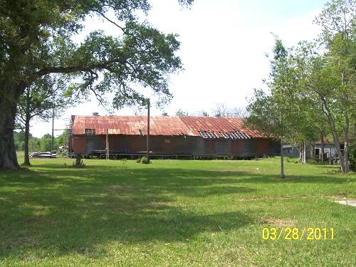
Next to the rails was another large dryer and maybe a mill.
If it ain't a mill, it's one heck of a dryer. I'm just fishing for
mill/dryer comments again. In reality they are castles on
the Cajun Prairie.

Next up was Iowa Junction. I was getting anxious. Bet you are, too.
But, first was this little house on the prairie.


I found my way back to Iowa Junction. Arriving there, the
Norfolk Southern train from the Lafayette yard did, also. I have timing.

See "Train Shot". That is where the above was shot. If
I could have crossed the tracks there I would have been
at Iowa Junction. These yappy little dogs were snapping
at my feet and legs until I got off and dropped kicked one
over the train. Then they cooled it. Who lets mongrels
like that roam around? I'll tell you who, people who don't
want strangers sneaking up on them, that's who. I guess
I should be glad they weren't rottweilers. Anyway, go there
with the knowledge there is no chance of a stealth entry.

Above you will see "Cement Block Shot". They were where
I realized that the next portion of this outing would
be upon a ghost line. I was ecstatic to be back in my element.
At the bottom of the map you see "Rail Tie Cemetery". I
felt like Professor Livingston finding the elephant graveyard.
The shot below looks like a pole is coming out of it, not so.
The cement was for some sort of signal, I guess, or had to do with a
crossing warning.

As did these.

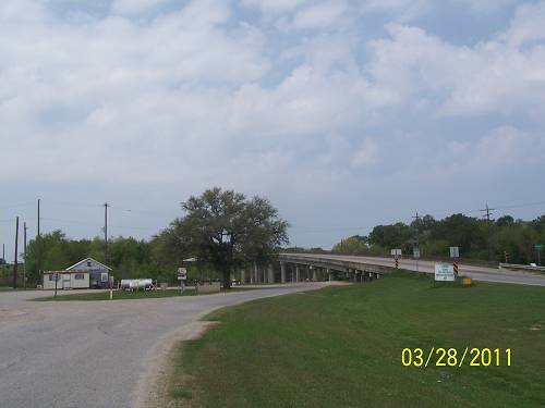
This is looking north to Iowa Junction from the US 90 crossing.
Of course you realize, and only by proof reading this, did I catch
the omission, that the Missouri Pacific had come down from
Alexandria, through Oakdale and Kinder, and proceeded across US
90 and looped beneath 90 headed to the Lake Charles industries
at the port. I have no idea when these rails were ripped up,
but my guess would be exactly 1978. The above information
is totally an assumption, so Scotty, if you plan on using this
for your masters thesis, you've been forewarned. I understand
that the great old wharfs at Lake Charles have been torn down.
These rails went there at one time. On the map you will see that
when the takeoff/landing runway was expanded or maybe, originally put it,
the rails had to make their way around the end of it. But, that's later.
We are just getting started.
Looking north to Iowa Junction from US 90:

Creosote on the ground next to the cement.


This is looking south across US 90 to where we will be next.
Check the map above.

Down Thomson Rd. I rode until I came to the crossing.
Looking southwest.

Looking northeast to US 90.

Then I saw it. Never let junk piles dissuade you from looking closer.

The attached tie plate was the clincher.


There was mud, deep mud, between it and me. Thankfully.
I say this is where the Missouri Pacific or UP had disposed
of the ties.
I turned west off of Thompson and came to Harris Mott Road.
It is where the rails finish their turn to the west.


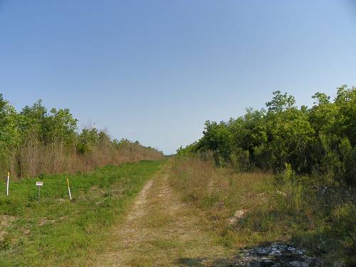
At Harris Mott, I got my first picture of the sweeping line.
Bon Air was out there somewhere. Another map shows
it in the apex of the turn.
It is that tree line in front of you. I was standing on the bed.
My mother kept telling me not to. Is that whyI have that
obsession today? Don't scar your children with
unclear admonishments. They may "take you" wrong.
They may visit reprisals upon you or the world in your absence.
Parenting is ............ It's just a crap shoot. Don't sweat
what you tell your kids. They're not listening. To heck
they are not. Say one thing they can use in an argument
and you'll be refreshed on that subject. What time is it?

Behind me was this shot. I was afraid the rest of the ROW
would be like this.

Panning to the north you can see the expanse of the land.
CLICK HERE FOR PAGE 2.

Gee, I hope you still have those maps around.
OK, I'm not going to be a jerk, what's one more upload.
Remember, these are icons. Click to open.

Again, we are at Harris Mott Rd. standing on the ROW looking
northeast at the westward turn. It was warming up, the
wind was blowing at about 12 mph from the north. There
was no sign of the forecasted thunder.
Again, a look at the area.
Next, with the ROW on my right, I headed down white
gravel Metzger Road. This stuff can be treacherous if thick.
It would get thick in the next section.

Looking down a coulee, I saw this. Now, to those who
don't know about historic right of way tracking, this is
a jewel in the crown. I dismounted and walked upon it as
if Lawrence of Arabia strutting his stuff upon the derailed
Turkish train. (You have to see the movie "Lawrence of Arabia.
It is takes place in WW I and offers a bit of insight into today's
problems.)

It was a moment.


This is looking west from the trestle.

The DL waited while I did the silly.


Then the white junk got deep and I drug my feet for miles.
If I and the bike took a tumble, I'd be eaten by a whole
zoo of critters.

The rails had angled away from the road, so there was
no plus to riding this awful road beside getting to where
the rails rejoined another road. At Leger, a blacktop road,
I shed all my extra clothing, drank and ate until I felt my
body responding to the therapy.

At Leger and Canal there was a settlement called Bellevue.
This is looking east. My map says this was the Union Pacific.
UP bought the MP, so, maybe they kept the rails live for a while
after the buy out in the mid 70's to early 80's.

At Manchester and Canal, the road crossed the rails.

OK, map time. See Canal, then Manchester and then Joe Spears.

This may be the crossing?

This shot was taken as a place marker for Joe Spears Road. I'd take
JS Rd. on in to La. 397.

Along Joe Spears I got off the bike and took a ROW shot west.

All right, we will take a look at the map. No, I'm putting
up a better one because this is getting thick and a plain
map is not going to do. We are at the spot on the map
where you see a line coming off of ours and headed south.
It is right where you see "Joe Spears" written. It is gone.
While at the map I want to point out several things. I think
our ROW crossed where the airport is and continued toward
the lake and the wharfs previously mentioned. The route
down to Harbor is the one that went to Lake Arthur. The
loop below the airport, starting where you see "Joe Spears",
is discussed below.

That's the hump where the loop going below the airport crossed
Joe Spears road where you see "Joe Spears" written.

This was taken standing on the hump looking west.

The gravel has been "mined out".

This is looking down our ROW to the west. Stuff is ahead.

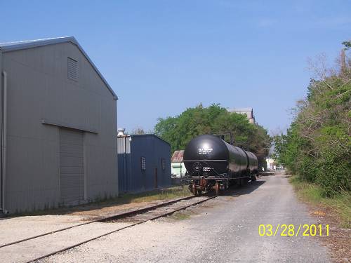
But, first, there was another jewel. This one had rails on it.
I could not chance a snake bite getting to it.

You can see the rails in this one.

I about lost it when I came to this sight.

Yes, the old branch was still partially in use. That was the icing
on the cake for me.

There had been a spur or a small yard here. Probably just
a sidetrack.


Across the road was this place. Al and I had stopped here
on the Lake Arthur or Mallard Junction adventures. It is
obvious the rails continued straight across the airport
property at one time. You are looking down the ROW.
That machine is on an approach from the Lake Arthur
Branch. In the foreground is our line joining the LA Branch.

This is looking north to possibly Mallard Junction. Yes.

Having it all come together is a wonderful thing.
This is looking toward Holmewood, though the line no longer gets
that far. I think it only makes the loop under the airport.
That leaves the possibility that there may be inner city
rails still there. Oh, boy, I'm kinda sorry about that realization.
Part 3 is find those rails.

See it go below the airport? There's no telling. We are sitting
at what was called Manchester.

This is the mill that is there with all the box cars.
It was established in 1917, or about the times the rails came here.

I was headed home. Right after the intersection of 397 and
US 90, going east, is Chloe. This is basically what is there.

90 lay before me. It was after 4pm. This is the unceremonious
beginning of US 165, the road to Kinder, Oakdale and Alexandria.
It is a UP route. Ahead to the northeast is Iowa Junction. Now
we know the rest of the story and why it was more important
in the past than it is now.

Riding down the road, suddenly I head a horn and fumbled
with the dormant camera. I wildly shot and pegged the engine.
By the way, that's an old Santa Fe engine behind the BNSF.
It hangs around the Lafayette Yard.


I could see the landscape below the cars clearly. Too bad
the shot didn't translate that.

At Esterwood, I shot the water tower. It's a habit.

There is a huge business you can see off of 90. I've wondered
what it was. It had tank cars lined up in the yard. I could not
find a sign and was too tired to push it.

Then, I came to Crowley. I follow the rails through town,
not the highway. AKDN comes down from Eunice and splits.
One set of rails parallel the main line for a bit before crossing
them to the mills on the south side. Remember the guy filling
the hopper car? This is looking toward 90 from the east back
up the split to Eunice.

This is looking east. What is that down there?

It is where a train can either continue to the left (behind that brush)
or be switched onto the approach to the main line where it rides a
short ways until it gets off at the mill.

If it chooses not to get on the main line it can continue on these
very old rails that have been cleaned up of brush. I was shocked.
This is looking back to the switch we just saw.

Turning around, there were a few new occupants. What's going
on? Is there going to be a rebirth of the Crowley rail scene by
the powerful AKDN RR at the forefront?
There has been nothing done to them. The ties are in
horrible shape.

The truth is, I think I've seen those tank cars on the west side
of the road, now they are on the east side, not that much
of a big deal.

But, what do I know? I was now among my castles. I want
to live up there.


These boxcars are on the south side of the main line east
of the mill. This was a large loading platform.


I get carried away.


I was back at the depot. The building on the left is a mystery.
The depot is straight ahead.

More Mardi Gras or Rice Festival Floats.


An old service station.

And, probably the same pond I shot earlier. I was ragged
out. Nothing had changed.

There is now a third page, "Into Lake Charles". It pulls
it all together. CLICK HERE to go there.
This had been a long one. It had been a win win on
several discoveries which I, and only a few others, would
appreciate. But, it was an outing with a purpose from which
I returned safe and sound, the second part of the "win win"
description. These aren't as easy and whimsical as they once
were. There were some teeth grinding moments and a longing
for it all to be over. Thank goodness for the Duson water tower.
It marks the Lafayette Parish border. On any trip west, it is a
welcome sight on the return. More later, maybe.
Page 3 Into Lake Charles
Al had asked, "What were you doing way over there in Lake Charles"?
I explained that a lot of what I'd been interested in historically, converged in LC. I guess that satisfied his inquisitive nature or he blew it off as randomly unimportant, which it probably is. But, not to me.
From my house to LC and back is 90 miles X 2. The good part about this ride is that it is on historic US 90 which travels through likewise historic communities all along the way, each with their personal attributes. Alone, the chance to visit Crowley is worth the ride. I fear the day the old mills and dryers start falling like they have in Kaplan.
But, 180 miles of commute is still 180 miles of commute.
Nevertheless, the unknown is not a challenge to me, it is an enemy that must be slain.
This ride, in an abbreviated form, was sent to a number of people by email. I am posting the Lake Charles portion of the ride here because I want to harp on some disappearing history that even my old Topo map does not include, it being a connector between the mainline (Southern Pacific/Louisiana Western RR) and the old Louisiana Pacific line that ran from Lake Charles to DeRidder and was eventually sold to the Sothern Pacific RR. Who owned what? in this maze is perplexing.
Click to enlarge. The "connector", in question, is in yellow.

But, as usual, I'm ahead of myself. Actually, I'll never
return to the mystery connector again in this write, as it's
a mystery and what I know, for sure, about it, I stated.
The railroad the connector connected to is featured in
The Red Sand Hill RR. You can check it out by CLICKING HERE.
Here we go.
This is a large map. I'm going to explain it all right now,
but you must click it to follow along. I suggest opening it
in a new window and putting it to the side so you don't
get lost in my explanation as I'll be citing from the map.
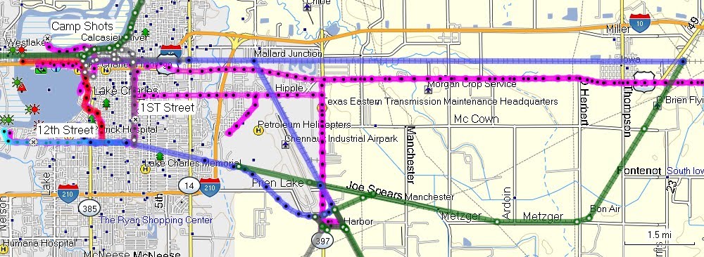
On page 2 of "Southwest of Iowa Junction", I stopped my
rail explanation of the Lake Charles area at La.397. Follow the green
line down until it meets the pinkish one. I'll be back to this
spot at the end of the explanation. I'll have to follow my tracks
on this ride or I'll forget something and that would be a tragedy.
I came in on US 90 from Iowa, the town. If you allow your
brain to think Iowa is a state in this instance, please close this
report and catch your balance.
I successfully avoided being sucked up on I-10/US 90 and went
directly to the Union Pacific yard. It is where you see the I-10 shield
partially covered.
The first engine was going the right way.

The second, wasn't.

Below is a very important sign. Railroad St. parallels the mainline.
1st runs south to 12th where the remaining live rails from
Iowa Junction run across the south side of Lake Charles to the
new port facilities. I say "new", because, evidently, there were
port facilities along the east bank of the lake. I've read that the
old wharfs were destroyed, a great disappointment to the writer.
I'd go down the imaginary rails that evidently serviced those wharfs.
1st Street is the vertical pinkish line to the right of the red line
which is the "Wharf Branch", what I'll call it.

From the corner of 1st and Railroad I rode south on 1st St.
as far as I could, stopped by I-10, and shot back to the north.
The rail bed was to my left.

Back up on Railroad, I shot across the yard at a couple of
old stores. Surviving historic architecture in LC is rare.
I think that the city fathers equated "a modern town"
with destroying everything old. That is the opinion of one
article I read with which I agreed.

Moving west on RR. St., I came upon a familiar area. The
two sets of engines conveniently mark the wye of the
Louisiana Pacific/ Southern Pacific tracks to DeRidder
which I followed in "Red Sand Hill Railroad".


These engines, below, may be connected to the AKDN RR
by way of lease. I need to compare numbers.

I panned to the east.

A few building skeletons, reflective of this area's prosperous
past, remain. LC, you missed a few.

To the west are the remains of the beautiful Lake Charles Depot.
Check out the Red Sand...RR report for pictures of all that.

The new depot is nice, but locked. It is also the bus depot.

While in the area I followed a spur north which sent me
out a peninsula. It is in the upper left of the map where
you see "Camp Shots", appropriately.

Swamp and the Calcasieu River.

Back at the main line, I crossed here on Ryan St., once the
proud main thoroughfare of Lake Charles.

Looking east, where I'd come from.

Looking west to the Calcasieu River rail bridge, where we'll go, almost.

The bridge location is below "Camp Shots". Below is the first section.
The I-10 bridge, across the Calcasieu River, is to the left (south).

With the new 26x zoom, I snagged the bridge. Look to the
right of the highway bridge, it's the third bump across the water.

One more look at "Old Rickety".

The pictures were taken at "Shot Here". Ignore the red line.

I then took flight and shot a train as it crossed. Large shot, click to open.
This is one of the few sites which feature a flying man.

After that thrill, I took to following the Wharf Branch south at ground level.

The red line, going south, is what I'm calling the "Wharf Branch".
Orange line is the 1st Street Branch, which I'll get to.
Large map, click.

Evidence of the rails along the lake is gone. At least my
rushed check did not turn up any. It is the red line near the lake.
At Common Street, there was a lot of evidence. it is the center
cement section down the middle of the street.


At 12th St., the rails coming from the Wharf Branch, joined
the rails coming from Iowa Junction.

At this point I'd go west and follow the existing rails to the
new port. They likewise would ride the center of the road
in stretches.


Moving west, the road (right lane) crosses the rails. No need
for a warning sign on the east bound lane.

At the port the rails fan in all directions.

I looked for an engine and found this one. A great picture, huh?

I turned around and headed back east on 12th.

The rails then angled south toward the airport.

Looking back toward 12th.

Looking east, the I-210 bridge can be seen. The airport is
beyond it. That is where the rails were rerouted below the airport.
The World War II era air base must have necessitated the rerouting
to make room for the long runways.

I moved one block to the corner of 1st and 12th. I was now
due south of the corner of 1st and Railroad. The rails ran with
the road.

The approach is marked by the abandoned car.

The rails ran right up the middle of the boulevard (1st)

The old corrugated building is one of the few historical
buildings left standing on 1st.

I-10, like from the north, was as far as I could legally go on 1st.

Again, the 26x zoom took me to the mainline.
Across from this point is the ancient connector mentioned
at the beginning of this write.

I returned to the one remaining historical building. Across
the street were the remains of the Broad Street crossing planks that
havw been cut up and used as a parking lot border. There were
clover shaped flat headed screws used to locate the crossing onto
the ties. Or, was there a station here??? I'll go with my original guess.


There are the old buildings. I was standing on the bed.

Next, I'd continue south, then east on 12th. I came to a pretty, and old, cemetery.


Below:
The green line below Mallard Cove Golf Course is
what I'm saying was rerouted to avoid the runway.
The purple line is the replacement. Pinkish is my track.
The purple going northwest from Mud Supply goes to
Mallard Junction, is active. It goes south and curves
to the 12th St. route to the new port.
Below the curve, there are no longer any rails in
place going to Harbor and eventually to Port Arthur.

This is looking from the bed above Harbor, south to Harbor.
This is looking north to "Mud Supply" and the La.397 crossing.

This is looking from La.397 toward the new bend from where
you see the line dropping from Joe Spears Road to the purple
bend to 12th St. How do I remember these?

Next are scenes along US 90 and the Old Spanish Trail
headed back to Jennings.


In Lafayette, I caught a train exiting the yard.

Murphy says, "Hi!!".

Next are some bonus shots.
While, "in flight", this is the head of that Calcasieu River
crossing train in West Port.

Here's a further magnified picture of the Calcasieu RR bridge.
It's "highly collectible.

Here a picture of the bridge from the new depot at the
corner of Railroad and Ryan St.

Above is also representative of how I feel after doing this report.
That's it. Oh, one more thing, if you enjoyed this write and you
think others might, pass it on. I'm having a low self esteem
period and may blow up all the blogs as an expression of power
unless I see the numbers of visitors increase. My psychiatrist
gave me the thumbs up on this decision, so take back your last thought.