Consumed with excitement I wrote Agent 00-L, an authority I hate to bother unless it is really, really important. Envision my passion as a third grader practically jumping out of his desk, waving his hand high in the air consumed with an all important to the world discovery. I was a balloon about to pop.
To move it along I won't include the pictures just yet. The class party is just beginning
I wrote:
I'm still looking at West BR Parish and I may have found something.
I know the route the Southern Pacific (BR Branch which crossed the Atchafalaya Basin from Lafayette, La.) took into Baton Rouge. The road that paralleled it (or was it) was called Southern Pacific Rd. That was pretty easy. Past SP Road's end to Anchorage becomes speculative to me. But, I've just found something that may turn the rails from "straight on" to Anchorage to a more twisting route. "Historic building and turn" (on the map) is the place I'm talking about. More below.
Sorry, no pictures yet. That's for later.
The place makes me believe the rails may have gone like this.
Sorry.
This is what I saw from above. I was thinking the old structure may have been a platform but in reality I think it's a shed. I'm not getting a good ground level view but it looks to be a building. More below.
Sorry, not yet.
Remnant of the hump is the little driveway to the left.
No.
It looks like a shed. See my red line (approximate route).
I have no mercy.
In response I got this from Agent OO-L:
My theory is that the pickup belongs to Mr. Boudreaux, who has come out from Port Allen on this March morning to feed his horses. He often comes out at night, too, theoretically with his buddies Thibeaux and Robichaux to drink beer. I can tell because he has blue reflectors from Walmart on each side of the driveway to his horse pasture gate, which he wouldn't need in the daytime.
Dumbfounded I shrank into a corner of dismay at his unexpected forensics.
Was Boudreaux's license plate to be my only lead? My balloon deflated.
Recovering, I read on:
I think that you have a valid hypothesis as far east as your historic building, but I see no evidence on the highly modified landscape beyond that point.
(more deflation)
I think that the "historic building" is just a shed containing several ramshackle horse stables, but what's important is that it and the conjoined modern picket fence out to the highway mark a cadastral boundary that is vestigial of the erstwhile railroad right of way.
(I inflated a bit after using the dictionary.)
Agent OO-L continues.
As I said, I believe that this was an SP alignment. However, it wasn't the only one.
Witness this 1908 topo showing a very different route:
Witness this 1908 topo showing a very different route:
Me: Look just below where you see "Ferriday" written vertically. The rails go mysteriously to the river.

He had upped the ante. Oh my goodness. Suddenly the mystery of a mile of track between the horse shed, beer drinking Boudreaux and Thibodeaux, and where the SP attached to other rails leading to the Missouri Pacific ferry became a side show.
My previous excitement suddenly was replaced and amplified by this new revelation.
What were these tracks to The River that went nowhere.
I gathered more stuff I had stashed away and sent it to the Agent.
This is confusing and later to be found in part incorrect.
I think I found the source for this somewhat mixed up offering that follows.
Or, she took it from a mixed up source.

I think I found the source for this somewhat mixed up offering that follows.
Or, she took it from a mixed up source.


He saw something I had dizzily missed:
Agent OO-L:
I did not know about the antebellum/postbellum Baton Rouge, Grosse Tete, and Opelousas RR. I suspect that it's what we're seeing on that 1908 map. It would have been long-abandoned but still there. The piece ... says that SP bought it and eventually included it [vaguely] in the Lafayette-Baton Rouge line, but that happened shortly after 1908. By that time, the Frisco family had its own ferry landing at Anchorage, so SP curved off and used that ferry from the beginning.
So, I think the 1908 mystery line was a disused relict of the BRGT&L.
Me: the noose on the actual facts was tightening but not yet a cinch.
Me: I found and presented a lot of material and then got this back from the Agent.
Steve and Mark,
I think that the Sunny South was the BRGT&O ferry where the then-disused line on the 1908 map meets the river. I think that line was operated by the BRGT&O and Louisiana Central until 1902. The line of the Frisco family arrived at Anchorage in 1906 and started its ferry there, where the boat was the George Walker. When the SP completed its line in 1911, it ran by Boudreaux's horse shed and to the Anchorage ferry instead.
We know from our previous work that the east-bank ferry landing was considerably south of Anchorage. It's between Anchorage and the BRGT&O line, so maybe it did not change locations through any of this.
Me: Oh my goodness!!
That statement is all important. The BRGT&O had aligned its rails with the "rail center" of Baton Rouge.
I'll use "rail center" since knowing the names of of old railroads is not my forte'.
I'll use "rail center" since knowing the names of of old railroads is not my forte'.
Now I'll let you in on the all the stuff I've found.
It seems I may have been late to the party because there is a Wiki article which already mentions the railroad. But, I'd find more that others had found, my forte'.
This from Wiki: I was still thinking that the mystery rails were to an SP Ferry, not to be so.
The BRGT&O had its own which predates the famous ferry, Walker.
The Baton Rouge, Gross-Tete and Opelousas Railroad was chartered in 1853.[4] The company had an eastern terminus on the west bank of the Mississippi River across from Baton Rouge in what later became the City of Port Allen. A steam ferry boat, the Sunny South, made three trips a day to connect the railroad to Baton Rouge. The railroad ran westward into neighboring Iberville Parish passing the village of Rosedale. After reaching Bayou Grosse-Tete near the village of Grosse Tete, the line turned to the northwest and ran to Livonia in Pointe Coupee Parish, Louisiana, a total distance of twenty-six miles. The roadbed westward from Livonia to the Atchafalaya River had been prepared by 1861".
Moving down the Wiki page:
"The Baton Rouge, Grosse Tete, and Opelousas Railroad resumed operation after the end of hostilities, but found the economy adverse, because of the devastation in agriculture. Moreover, its sixty-nine slaves had been emancipated and had to be replaced with hired labor. Furthermore, the "Great Crevasse", which occurred in the north end of West Baton Rouge Parish in 1867, caused flooding that greatly damaged the track in a low section about six miles west of the Mississippi River. The now unprofitable rail company eventually ceased operations in 1883. The assets of the railroad were acquired by the Louisiana Central Railroad and operated until 1902".
Me: I am having a hard time finding any material on the La.Central.
No, not the model railroad.
I have found Louisiana Central Railroad of Louisiana in a Wiki Listing. All I find on the Wiki page is that it was eventually in the Missouri Pacific family which makes sense because the MP's ferry was nearby. Wiki goes on to say it existed between 1868 and 1870 and was succeeded by the New Orleans Baton Rouge and Vicksburg RR.(1869 to 1881) when it was then taken over by the New Orleans Pacific which quickly was bought by the Texas and Pacific RR, a Missouri Pacific RR company)
And it goes on.
"The Southern Pacific Railroad built a spur line from Lafayette, Louisiana to Anchorage in West Baton Rouge very early in the twentieth century. The line ran in a straight line and is notable for crossing the Atchafalaya Basin. The line was never financially successful and was abandoned in the 1920s. Southern Pacific Road occupies the former right-of-way of a small portion of the (BRGT&O) line".
The BRGT&O had its own which predates the famous ferry, Walker.
Historic era
"West Baton Rouge Parish was formed in 1807; it was named Baton Rouge Parish until 1812.The Baton Rouge, Gross-Tete and Opelousas Railroad was chartered in 1853.[4] The company had an eastern terminus on the west bank of the Mississippi River across from Baton Rouge in what later became the City of Port Allen. A steam ferry boat, the Sunny South, made three trips a day to connect the railroad to Baton Rouge. The railroad ran westward into neighboring Iberville Parish passing the village of Rosedale. After reaching Bayou Grosse-Tete near the village of Grosse Tete, the line turned to the northwest and ran to Livonia in Pointe Coupee Parish, Louisiana, a total distance of twenty-six miles. The roadbed westward from Livonia to the Atchafalaya River had been prepared by 1861".
Moving down the Wiki page:
"The Baton Rouge, Grosse Tete, and Opelousas Railroad resumed operation after the end of hostilities, but found the economy adverse, because of the devastation in agriculture. Moreover, its sixty-nine slaves had been emancipated and had to be replaced with hired labor. Furthermore, the "Great Crevasse", which occurred in the north end of West Baton Rouge Parish in 1867, caused flooding that greatly damaged the track in a low section about six miles west of the Mississippi River. The now unprofitable rail company eventually ceased operations in 1883. The assets of the railroad were acquired by the Louisiana Central Railroad and operated until 1902".
Me: I am having a hard time finding any material on the La.Central.
No, not the model railroad.
I have found Louisiana Central Railroad of Louisiana in a Wiki Listing. All I find on the Wiki page is that it was eventually in the Missouri Pacific family which makes sense because the MP's ferry was nearby. Wiki goes on to say it existed between 1868 and 1870 and was succeeded by the New Orleans Baton Rouge and Vicksburg RR.(1869 to 1881) when it was then taken over by the New Orleans Pacific which quickly was bought by the Texas and Pacific RR, a Missouri Pacific RR company)
And it goes on.
"The Southern Pacific Railroad built a spur line from Lafayette, Louisiana to Anchorage in West Baton Rouge very early in the twentieth century. The line ran in a straight line and is notable for crossing the Atchafalaya Basin. The line was never financially successful and was abandoned in the 1920s. Southern Pacific Road occupies the former right-of-way of a small portion of the (BRGT&O) line".
Then I said this:
I'm thinking the above writer (Mary Ann) is mixing up info. Was the Sunny South a MP ferry?
The answer is "no" as mentioned above by 00. The Sunny South was the BRGT&O's ferry. That is earthshaking in my world.
Now some maps to keep you interested because there will more dry data to follow.
This is cut from the Agent's 1908 map. It shows the alignment of the BRGT&O's Ferry with the now Canadian National, once the Illinois Central's yard (Previously I called it the Baton Rouge's rail center) and the rails going east. That makes sense for a short ferry crossing, not the longer one that the MP ferry would have to take to the established Baton Rouge side landing
from the Anchorage (Sunshine, La) location.
from the Anchorage (Sunshine, La) location.

This map shows the line minus 12 miles that went up to Livonia.
This proves that the Southern Pacific did not follow the BRGT&O
This proves that the Southern Pacific did not follow the BRGT&O
The SP basically followed Interstate 10 west. No, Interstate 10 was not there in the 1860's.
I have to be clear because history is no longer taught the way it once was. There are changes.

Me: This was a revelation. This little railroad with grand expectations was born in antebellum times.
It ranks with the New Orleans, Opelousas and Great Western RR as a pioneer.
"Opelousas" is a part of many a railroad name.
I wonder why. There are good eateries.
The yellowed words are "search engine" words I used and you can, too.
Here is the history.


The explanation is a little off. The railroad connects
the soon to be town of Port Allen to the west.

Let me write out some of the facts about the railroad according to this one site I visited.
The information below is all quoted from there.
I'm not old enough to write a bibliography so a link will have to do.
The quoting begins.
The track was 29 miles long. It was 5'6'' gauge of unknown type and weight.
8 miles are mentioned being 50#.
8 miles are mentioned being 50#.
Me: the gauge matches that of the NOO&GW's early attempt.
There were 17 cars.

There were 3 engines, the Slack, the Atchafalaya, and the J.V. Duralde
(the president of the company, I think I remember).
"At least 2 of the locomotives were Moore & Richardson".
There were 5 stations:
Baton Rouge
Lake (which I can't find)
Rosedale (which still has a great T&P depot)
Maringouin ("mosquito" in French)
and Livonia (world famous as a railroading crossroads and it's hump yard)
Directly stolen from that great site are these cut outs of info he found or information I copied from them.
Links to these are found here:
| NP, ADV 1-1-61 |
| NP, ADV 6-10-61 |
| NP, NOBC 1-6-62 |
| NP, STD 2-9-61 |
| NP, OC 3-22-62 |
| OR Series 1, Vol. 34, Part 2, Page 1005 |
You can click these to enlarge or go to the original links above.


And this from the man himself, General Richard Taylor: Click to enlarge.

Remember this from above? You can see how the information
then, and in some recent writings was mixed up and the
SP did not buy the line. The Louisiana Central RR did.
Louisiana Central is listed as a Missouri Pacific/ Texas & Pacific Line.
Possibly the SP bought a little bit of it from them.
That's the way I see it anyhow and what do I know?
There are reams of added BR, GT&O info below.
Now on to what I originally had in mind for this write, my discovery,
a place where there is a horse shed and where 2 good ol' boys and their friends and
invitees drink beer.
Mark and I just came back from there. Burp.
This will take 2 seconds because I'm not arguing.

This is the hump on La.987
.
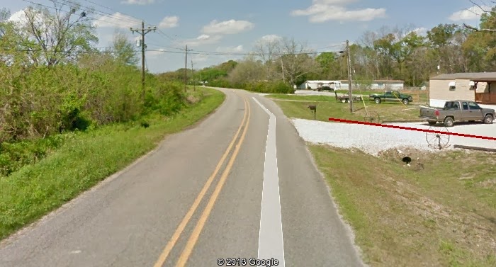
The "Historic Building" is a horse shed, NOW.
Let's get that out of the way.
I've related that Agent 00-L is with me as far at that goes.
After that point is my wild speculation. And it goes like this.
Remember the plant was not there in 1911.
Still there are things there that guide me that the plant and tank farm might have used, like the bed.

Now this is what turned the line for me.
The fence and the shed make sense.
I don't think it was always a horse shed.
Seems a horse shed wouldn't be aligned with a long gone railroad.
Those horses would be spooked.

The red line is floating out there.
Looking to the east this is my interpretation.
But, maybe not. Missing out with the T&P interchange might not have been that smart.
Sigh, the food was good but the indigestion, horrible. Oh well.
One more thought below.

I just did it again to make sure I still felt that way.
Yep, same results. It has to be considered.
Now on to what I originally had in mind for this write, my discovery,
a place where there is a horse shed and where 2 good ol' boys and their friends and
invitees drink beer.
Mark and I just came back from there. Burp.
This will take 2 seconds because I'm not arguing.
Simply, the Southern Pacific, Baton Rouge Branch, took off from Lafayette, hopped The Basin, landed
on solid ground and ended up angling up from the flat west to east line and headed to the levee.
I've heard that it joined the Missouri Pacific's yard on its western side.That would be roughly
above where you the "c" in "Historic" where the pin is.
I'm differing since that's my mission. I say it turned.
Joining another company's yard makes no sense to me.
I concede later so don't get all steamed up.
You'll bust a boiler.
This is the hump on La.987
.
The "Historic Building" is a horse shed, NOW.
Let's get that out of the way.
I've related that Agent 00-L is with me as far at that goes.
After that point is my wild speculation. And it goes like this.
Remember the plant was not there in 1911.
Still there are things there that guide me that the plant and tank farm might have used, like the bed.
Now this is what turned the line for me.
The fence and the shed make sense.
I don't think it was always a horse shed.
Seems a horse shed wouldn't be aligned with a long gone railroad.
Those horses would be spooked.
The red line is floating out there.

Looking to the east this is my interpretation.
But, maybe not. Missing out with the T&P interchange might not have been that smart.
Sigh, the food was good but the indigestion, horrible. Oh well.
One more thought below.
I just did it again to make sure I still felt that way.
Yep, same results. It has to be considered.
More later, I'm sure.
Later is now.
It is Saturday morning and I am finding more.
This from Here
It is part of This, A GOLD MINE
Later is now.
It is Saturday morning and I am finding more.
This from Here
It is part of This, A GOLD MINE
Case 5: Transportation and Progress
Baton Rouge has been a port city since its beginning. Author Charles
East states that the Baton Rouge story goes from an "Indian site on
the banks of the river to the booming commercial and industrial city
of the [eighteen-] nineties a city shaped by innumerable twists and
turns of history, but perhaps by none more crucial than Standard Oil's
decision to build a refinery here in the early 1900s." The
petrochemical industry has dominated the banks of the Mississippi
River since 1909, when the Standard Oil Company opened its refinery in
Baton Rouge.
In the 1920s, the city was known as the "greatest of fresh water
harbors." Ships docked at the foot of Third Street until 1926, when
the Baton Rouge Municipal Dock was completed at a cost of $550,000.
The dock was located where the Mississippi River Bridge meets the
eastern shore.
Limited rail transport came close to Baton Rouge in 1857. Private
subscriptions and a $50,000 bonus from the city of Baton Rouge paid
for the construction of the Baton Rouge, Grosse Tete, and Opelousas
Railroad to serve the large sugar plantations west of the river. The
rails ran only from Port Allen to Grosse Tete. Despite the issuance of
stock certificates in 1867, the railroad did not survive the Civil
War. Southern Pacific purchased its rails and rolling stock and took
them away for use elsewhere.
In 1883 prosperity returned to Baton Rouge with the establishment of
the New Orleans & Mississippi Valley Railroad, which connected the
city to New Orleans. By 1940 Baton Rouge was connected by rail to all
parts of the country.
Although Baton Rouge is still a railroad town, highways have gradually
replaced the railroad as carriers of people and freight. Not until
1940, however, was a bridge built across the Mississippi River at
Baton Rouge. The combined highway and railroad bridge, started in
1937, cost $10 million and is 2.5 miles long. It was only the second
bridge in the state to cross the Mississippi; the first was in New
Orleans. In the 1960s construction began on a "new" Mississippi River
bridge to connect Interstate Highways 10 and 110. Now one of the
busiest interstate highways in the nation, I-10 dominates transit in
the city.
The following gold is from HERE.


It seems that bonds were issued later.


1858

Convict Leasing in the Postbellum Era
From Here.
As it was in other spheres, the Civil War marked a turning point in penal history. The textile factory in use during Hart and Pike’s lease was completely destroyed; only the walls and roof of the carpenter’s shop and the pressroom remained standing. In this chaos, forty-five convicts were sent to the Baton Rouge, Grosse Tete and Opelousas Railroad, which was partly state-owned, to repair the tracks at fifty cents per convict per day. This was only a makeshift arrangement, however. The convicts returned to Baton Rouge and its dilapidated prison in January 1867.
That's about it. I'm out of gas on this one.
I'm filled up again.
Remember that the Central Louisiana Railroad bought the remains of the BRGT&O.


Map of BRGT&O completed to Maringouin.

Map of the LNO&T mentioned above.
And, that's all I'm doing on this one.

I'm filled up again.
Remember that the Central Louisiana Railroad bought the remains of the BRGT&O.
I am waiting on several questions to be answered.
What is meant by "cut off" and what what were the CLRR's intentions.
Continued from above.
Map of BRGT&O completed to Maringouin.
Map of the LNO&T mentioned above.
And, that's all I'm doing on this one.