I told my wife I was going to Cypremort Point, or locally known as "The Point".
She seemed to approve that I was doing something different.
Perhaps she didn't realize it was, at one time, a very common ride.
This is not going to be about trains for the most part though it does start with a couple of engines.
I saved this picture because it will add symmetry to a very symmetrical outing.

South of New Iberia, La., I headed farther south on Highway 83.
All of this ride will be in Louisiana so I'm leaving "La." out of the description for the duration.
Interstate rides will be designated accordingly.

The houses down here are elevated, not for the view.

The road is straight because it has not chosen a bayou to follow, yet. Bayous are not straight.
No social comment intended.

At the first bayou crossed, there is a change.

Notice the "bump" on the right.

This is the new Warehouse Bayou drawbridge.
It has also been designated as the Bayou Patout drawbridge.
Debate rages.

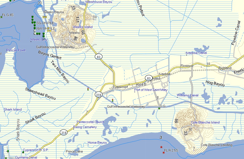
At this point we need a map.
The first bayou w/o the bridge was Weeks Bayou.
Same "Weeks" as in "Weeks Island", shown.
The second waterway with the bridge is Warehouse Bayou.
It was labelled Bayou Patout, but my map shows Bayou Patout
connecting Weeks Bayou with Warehouse Bayou.
I hope this does not stir controversy though I am always ready, bring it on.

Warehouse or Patout. Do you really care? Choose your battles carefully.

Immediately, we climb up the Weeks Uplift. (I made that term up to look smart).


The remnants of the Southern Pacific Railroad tracks can be seen here.
That statement may start a controversy.
I'm prepared for that.
I have conferred with the authority on all things "SP". He says the tracks did belong to the railroad.


If you go down that intersecting road for a short distance, you will see what you have had to imagine.
Shifting from imagination to reality can be a shock, so proceed with that knowledge.

Below is an example of the inner conflict which often accompanies these ride reports.
Here's my preparation. This is the distance from Baldwin, the beginning of the Cypremort Branch. If these rails belonged to the salt mine, then they would not be marked with a mile marker unless the rails were a joint venture or part of a joint agreement.. There was an small yard where the tracks turn toward Baldwin. My guess is that it was the interchange and that SP engines needed to go no farther. But, I'm intrigued by this pole that is such a historical landmark.
The expert said that all the rails were SP. So, I lost sleep for nothing last night.

Map time.
Notice the railroad and the Gulf Intracoastal Waterway. We'll cross both, soon.

Another map.
The crossing, below, is where you see "Cypremort".
The area is also called "Louisa".
The crossing below is at the rails above "Cypremort".
The Louisa Plantation was just south and bordering on those rails.
There was once a molasses, my bet, filling apparatus there which has now been knocked down.
Yes, I have pictures of it. Thank goodness for me.

The painted road is a phenomenal historic landmark.

This is the mill area. There is a large gear sitting on top of that concrete pedestal.
When I think of gears I think of grinding. In this case gears and grinding, again, tell the story.

This is looking east on those rails.What is left of the loading structure is on the ground to the left.

This is looking west toward the GIW. OK, a hint, "Gulf .... Intra ......."

Reference the bridge of the maps above. We are going over the GIW.

And, down. The bike was shaking in the wind so I was a little shaky, myself.
Thus, there were few pictures going over this time.
I'd gain composure on the return and snap some startling shots.

Going down.

Shot over my right shoulder going down. The high area is Weeks Island. It is recognizable by its hump.

Then, the first wave of camps begin.


Camp?

Jean Lafitte's Camp.

The Baptist Church.

A place I found.


The parish has supplied a folding chair.


Notice: Place I found.

Shortly thereafter, a second wave of camps begins. This area is also the entrance to the state park.

This sign dates prior to Hurricane Rita (2005, Katrina's destructive sister). It was the location of a drive in, so it reads. I can't read the rest.

Some live here all the time, some don't.

This is a pre Rita landmark. It has been painted since the storm.

The oaks, some take for granted. I don't.

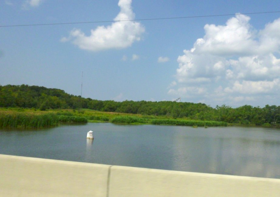
Open water is ahead.

Does seafood and bait collide at some point?


Little boats.

Big boats. On these waters, there is no replacement for "Big".

We are in Cypremort Point proper, "Camps 3" on the map, below.


The porch has no access. I don't get it.


The :"metal building" motif is nice. I like it.

Wharf. Yea, it has an "h". Learn something everyday.

Indigenous Cypremort Palm Trees.

New gates on old rebuilt communities. Guess "they don't want them long hairs hanging round".
If you recognize that quote, you predate a lot of stuff.


I was at my destination though it no longer resembles what was there before.
The building that was there, the old Bayview Bar and Lounge, was where I saw
the first moon landing from a building that looked like a boat.
I suggest that a boat and a moon lander do have similarities.
The bar huggers all swore that it was a Hollywood production.
I didn't argue with the gnarly shrimpers and weekend warriors.
Reflecting, I'm still not sure. News flash: The government does lie.


This is where the moon landing took place. Notice the date.
Cypremort Point has been a destination for a while.

This was when the present version was being built.

It's all changed, not for the better. and it is now a "private residence".
The port holes are gone. Why?
I was thinking of driving my wife down here to eat.
Whew, saved that blunder.

It had a wharf with picnic tables. So neat. Now it's gone.

The ability to come out here is disappearing soon. It will be sold for condos. This is "The Point".
This place is so fragile. All the other accesses to The Point are gated. Visit soon. Bring a folding chair
or borrow the parish's.

These are the views.

A posted post? You can't post the bay. So it begins.


This is the last "working man's" access. These are shrimp boats. I once took a picture of one of the boats,
posted it in a ride report and then received a note from a lady soldier in S.Korea saying that I'd shot her
uncle's boat and that she so appreciated it. Made my day.

Good-bye Bayview.

The old couple that had given it "a go" were real nice. I hate to see that the family didn't make it.

A Venice canal?


Nets?


When I took this it didn't register that it was all open. I wonder if it was a public place? I'll bet the view is
worth the climb.


Directions are not needed down here.


Small shrimper.


Private dock for sale on Cypremort Bayou, the bayou that built The Point from its yearly flooding.

Pampa Grass

Old architecture. Very tasteful.

Never finished.


Fire Dept. and back at the Catholic Church.


Up, way up.

Over my shoulder. I was not as shaky.

I shot both islands while on top.
The bridge is where you see "319" at The Canal.
These labels are guesses.
The hump is definitive. That has to be Weeks Island.

This is Cote Blanche. (I've changed my guesses twice)

There's the canal, the island is to the its north making it "Weeks".

The Canal looking toward Vermilion Bay. I have better pictures which are long distance.
You can see The Canal bending to the north and skirting the bay. I'm too lazy to find them.

Cote Blanche Island is to the south of The Canal. This was taken over my right shoulder.

Going down. You can see the land rise ahead.

Saying so long to Cypremort Point.

Back to the railroad.
I was now just east of the Louisa Mill. This is looking into her yard.
The track to the right curved right and went to Weeks Island, all SP.
I know, I persist.

I headed east on the back road thinking about fried shrimp. I hope you are, too.

I was nearing the Port of St. Mary (Parish). Here large and small boats are dry docked.

Quilts are for sale.

This is Area 52.

Wake up.


Check them out, HERE.
They now operate the Cote Blanche Mine.
I'll have to check my old shots to figure out who did before.

Cote Blanche areal. The water leads to the Intracoastal.

Looks like this is where I stopped last night. Might have been bored? I can't help shooting track.

Headed to Baldwin.

I decided to do one more deja vu area, Freetown Rd. The name has Civil War era origins.

At the Freetown crossing. I don't think there was a depot here.


The historic Methodist Church.


On up the road returning to Hwy.83. Sugarcane planting preparations.

Then it happened. My time and space powers exploded and the old Louisiana & Delta engine No.1504 appeared. Her nickname is Patoutville. I call her Mz Patout. I'm sure I am sure I am her only one.


"The 1504 was originally Santa Fe F7A 206C, then ATSF CF7 2489 and then Cadillac & Lake City 48. The CLK was initially a Michigan railroad; but it used this locomotive on former Rock Island trackage in Colorado, which is why the paint scheme featured the Rocky Mountains! L&D got it in November 1989".
Description by Mike Palmieri.


| . |

I arrived at Balwin and saw that L&D was preparing a train to go to Bayou Sale.
In transit to the rails I passed a house form which a group of thugs had chased me.
Seems that Mr.Karma had gotten them or voodoo works better than expected.

I would hear her cleared, on the radio, to MP 95 a few hours later.
L&D 1500 & 1504 are the old engines kept at Baldwin.


I have no explanation for this shot.

Here's the old store by the tracks. I will bet LZ frequented it back in the day.

Now my memory becomes hazy again.
Time for a map. I was now at Baldwin, lower right area.
I headed to Bayou Sale since I was in the neighborhood.
Nothing was cooking there, yet, so I crossed the bridge at Centerville and headed east on Hwy.87, the back
road opposite {across Bayou Teche} from old US 90.

Yes, it was the long way which was made longer by having to reverse
(see dead end segment past Charenton).

More sugarcane preparations.

At Bayou Sale, the stranded steel carrying gondola had been unloaded.

I was now at Centerville where I saw this. I was taking a picture of the old service station. Upon reviewing
it seems that I may have broken the law by using my cellphone on La.182. Also, if smoking, watch yourself.
It is hard to fathom what a double jeopardy might bring.

Dang. There is a similar building in Patterson which was a bank. I will bet they were the same company.
I cut off the top which might have held the name.


Crossing the Teche headed to Hwy. 87.


Why is this lonesome, unused and newly paved highway newly paved?
My highway is a death zone. This is an example of corruption.

Leaving Franklin headed out Irish Bend Road.

I had to go by Mr. Martin's store.

He was a great guy who beat Walmart until his death.


He once had an uncle that lived upstairs. I got the idea that the uncle was strange.
He had to close down the the honkytonk side of the building which served the field hands.
Why? Because he got tired of breaking up knife fights.
There are more. He ran the place from 1935.


I ran down Irish Bend until I got to the high Missouri RR hump. Looking toward the bayou there was
something orange occupying its alignment. A friend's uncle was the bridge tender here and I've always
wanted to find his house or its location.


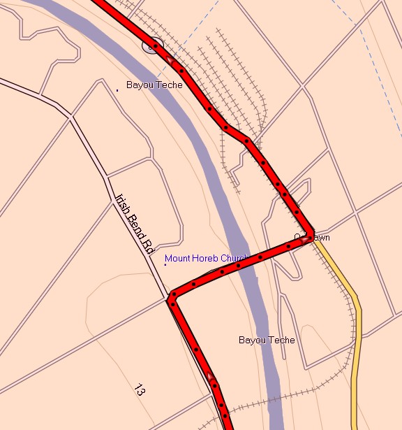
Oaklawn.

Worker's houses.

Oaklawn Bridge.


Now here it gets interesting. Here's the map. At the bottom you can see the railroad cross the bayou.
It curved north staying on the west side of the present road. It then entered the mill. That area has been
overgrown and inaccessible until now. I wish I'd been here when it was being cleared. I am sure much
history was lost.
I took pictures with the little camera. I should have broken out the one that could zoom.
After crossing the imaginary track, I turned left.

Looking to the right first. You never know.

The present farm operations building occupies the area across the road.
Another map to prepare you. This is a look down on the old mill location.
The green lines are old roads. You see that one goes by the existing farm building.
The purple line depicts the Missouri Pacific main line.
You will see a black line in the upper left corner. It was a railroad spur
servicing the mill. More below.

There's the farm maintenance building.

Looking west at the mill area.

Time for a map since there is evidence in these pictures.
The black lines were car storage. The purple line is the main line.
And there's the mill service spur shown above.

Below is a 2014 map before the devastation. See "fuel tanks" on the right. Click this map for larger version.

There they are.


This is probably that building to the right.


More new highway. But it would end in construction and I'd have to reverse to the Charenton bridge.

At Charenton I had to take a shot at the old bar and brothel. How do I know that,
because some giggling ladies told me.

This was the library. Much can be said about the difference in size.

At New Iberia I intersected the train I'd seen at the beginning of this ride.

Symmetry had been achieved while not using a cell phone or smoking anything. I promise.
