This page gets a little manic. You may want to take a sedative first. It was written as a means to compare notes with fellow rail-oligens in the field. If you come to a point where all of this becomes too technical, feel free to leave and have a seat in the lobby until the whistle is blown.
As you know, or could have known if you had read the previous 98 pages having to do with the
OGNE Railroad, I have physically pursued this old railroad at length. I've also pursued what history I could find without getting off my butt. From what I've read, the railroad got off the ground about 1904, or a little later, but that could be completely wrong. I'll go out on a limb, further, by saying that the financiers were in New York, New York, so big you have to say it twice.
To support my guess at the OG's date of birth, I found a clip that mentions the approval of plans for the Bayou
Courtableau Bridge at Port Barre, an important link in the Melville branch of the
OG. The date reads, "February 27, 1906".

Then I found this genealogical clipping. Charles was a surveyor
mapping the proposed railroad in 1905. He, according to that court
case, was the chief construction engineer of the
OGNE. Whoa!

This is his court testimony when Crowley residents were suing the city and the railroad in
an appeals case after learning that
Rayne would definitely be included in the route. The two towns were bitter rivals and the citizens of Crowley had put up $70k by way of a tax election. The plaintiffs claimed that voters would not have voted for the tax had they known that
Rayne was included in the route and would be the first to intersect the Louisiana Western on the proposed
OGNE line. Later, I found a schedule which shows that both towns had
OG connections with the
LW, but
Rayne would still hold an advantage dealing with the
OG to the north.
Here's the chief engineer,
Genung's testimony.
Notice the tricky question, "running to, Crowley,
thence to Rayne".
The route to which the
Crowleyians objected was
the one that went to
Rayne,
"thence to Crowley".

Wonder where he hid them?
Here's a little history that led to the south branch from
Opelousas to Crowley
being built. Old DD was born in Breaux Bridge. How about that. These guys
were rock and roll, getterdone, rain or sun.
"In 1886, through the assistance of his brother, C. C.
Duson, who had resigned
from the office of sheriff to go to the state senate, and with the aid of some
others, Acadia parish was cut off from St. Landry parish, and later the parish
seat was located where the city of Crowley now stands. At that time there
were not more than a half-dozen houses in all of the western portion of Acadia
parish.
In the autumn of 1886 the town of Crowley was located and laid out.
The difficulties encountered were many, as it seemed impossible to get the
confidence or co-operation of anyone, not even the railroad company. All
other efforts having proved fruitless, Mr.
Duson went to C. P. Huntington of
the Southern Pacific R; R. and succeeded in having a depot located at Crowley,
but not until he, Mr.
Duson, bad personally guaranteed the agent's salary and
other expenses connected with maintenance of the depot for a period of 6
months, even to the extent of paying $100 for temporary installation of
Western Union telegraph service.
By 1890 the railroad's books showed that Crowley was the second largest shipping point between Lafayette and Houston, Tex. From the date of the first sale Mr.
Duson concentrated his efforts upon the development of this immediate section, making rice the principal product. He bought the first binders and threshing machinery, built the first irrigating canals, assisted in building the first rice mills, and along with the building of immense canals developed the road system. So fast were the improvements and rapid the agricultural development, that, regardless of the efforts of the Southern Pacific R. R., it became impossible to get outgoing and incoming transportation sufficient for the section's immediate needs".
The Opelousas, Gulf & Northeastern R. R. was induced to build a line to Crowley, which was shortly followed by the Frisco system.From:
"Louisiana: Comprising Sketches of Parishes, Towns, Events,
Institutions, and Persons", Arranged in
Cyclopedic Form (volume 3), pp.
134-139. Edited by
Alcée Fortier, Lit.D. Published in 1914, by Century
Historical Association
[But the write skips and does not name a date that the the
OG "was induced"].
I suppose we can believe it arrived in Crowley and
Rayne around 1907.
In the taxpayer lawsuit, it is mentioned that construction should be finished 18 months from the end of surveying.
Genung was in the field in December of 1905 in Roberts Cove, 8 miles from Crowley. He would have to abandoned the plans for Branch to Crowley and replace then with a route from Branch to
Rayne, then one going 2 miles south of
Rayne and turning west, 7 or 8 miles, to Crowley. It seems to me, at best, the rails to Crowley, via
Rayne, would not be completed until late 1907. I now see that on two occasions I came to the same conclusion.
The lawsuit attached the results of a tax election in May of 1905. The tax was to be levied in 1909". I think the court date was in 1906 or '07. I wonder what kind of welcome the OG got in Crowley when it arrived the next year? By the way, the plaintiffs lost and were stuck with a tax to cover $70k in 1909. The OG was bankrupt in 1915. Could a backlash and the rr's demise dovetailed.
The following was probably copied from the
a state agency record book. The
OG would
have a "high tech" control building where
the
OG crossed the Western Louisiana RR

Below are shots of the intersection and trains traversing it.
We'll be there momentarily.

Here's the1913 Louisiana Western (SP) Freight Schedule.
Stops are shown at both
Rayne and Crowley.

This clip shows that the
OG name came to an end in 1915.
The Texas and Pacific bought what it had not already
assumed at an auction.

Below was its route. I suspect all of it was absorbed by the
Texas & Pacific for a while.

The following investigation covers the 11 miles between
Rayne and the
OG's connection with the La. Western and the
Frisco on the west end of Mill Road in south Crowley. That
last sentence can be challenged for historical correctness.
Carry on if you must.
Here's the 1912 account. The Frisco (earlier the NO T&M?) rails
and depot were above the Southern Pacific route.
Therefore, it is my feeling that the
OG extended
the full length of
Mill Road and connected to the Frisco as she turned north
toward Eunice. "On the ground" evidence tends that way except
for a pesky switch which was identified as being used by the
Southern Pacific. That may still not be a problem with my thesis.
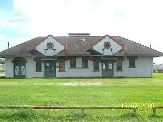
The
OGNE RR Depot at Crowley.

The Frisco Depot at Crowley, north side of SP tracks.
.jpg)
Where was the
Southen Pacific Depot? I think I know where
the water tower was. And, the
Rayne SP Depot was downtown.
I've found no historic pictures of the OG Rayne Depot. I would guess
that it was in the neighborhood of the control tower. By the
way, though the tower was built by the
OG, the SP trains had rights
over the
OG ones.
Since this will be the shortest page of the next 5, I'll stick
this info in here. There will be a lot of pictures and confusing
explanation before we get to the Frisco/
AKDN end of this ride,
if we do. Since I'm doing history right now, here's something on the
Acadiana RW Co, successor on those rails to Eunice from Crowley.
Click this to enlarge. It explains what many think is a recent railroad.
This is a very dated clip, 1990.

Here's the simplified map from the law suite.
Seems Robert's Cove missed the boat. Those
two ditch scenes with ties lying in them were
on the
Lewisburg (
Opleousas end) to Branch
section. I may have failed to note that on one
of the last pages.
 Rayne to West Crowley
When I'm looking for something I like to start in a familiar
place, then work into the unknown. I knew where
the
OG came into
Rayne, north of Interstate 10. I'd been
there and done a full report on its route all the way to the
"Southern Pacific" tracks. Past there was Indian Country.
If La. 35 hadn't done a chicane, then it would be here. Maybe
this was old La.35, also.
.jpg)
I'm not saying this old bridge was a trestle.
.jpg)
Those are makeshift power or telephone poles down there.
Check out the nub on one where a glass insulator would
screw on. I have a few of those as my father in law chased
wire for a while. BTW, I mentioned this in another ride:
If you get bored of riding in the same old places, follow
some power lines. I've followed rivers and rails and found a
lot of stuff. I think power lines could be the new rabbit for
any ol' bored hound dog. You could always write that it was
an electrifying experience. That was bad.
.jpg)
This lines up with this. The train passed through here.
and continued between the break in the trees on the
other side of the SP and US Highway 90.

Well, maybe in the last days of its existence. That control
tower with all the bells and switches was here, on the left
before the UP/SP east-west tracks. We are coming from the
north, headed south across those tracks. Notice the shell
road. It lays on top of the rail approach to the the Southern
Pacific tracks. (UP now) It is on Everett's map below.
A block above this dryer is a large open lot. It is where the depot was.
Everett has offered up a map and comment.
"
By the way, the Rayne depot was one block north of the rice dryer. The tracks were there at least into the middle 1980s, and the depot was where I show it on the photo that I included. The tracks served both the rice dryer and the bulk plant, but did not look at all used at that time". 
.jpg)
Here's looking from the other side of 90 and the SP back
to the last shot. I figured the street to be partially the right of way.
Below are
waypoints placed at approximate positions where the
OGran across the fields to Crowley. This may be the only list available
in the world, so guard it well. I may one day waypoint places where
they are instead of from where I took pictures of them. That explains
why each spot is not on the same latitude or, possibly Charles Carter
Genung was not such a hot surveyor?

The numbers on the left correspond with the numbers
on the map. Click the map if you can't read it.

This next picture was taken when I hadn't found the ROW yet.
Many were taken that were guesses. I kept this one because
I liked it. After I looked at it I started to think, what is a hill
doing out here? Was I looking at an ancient
chenier or salt dome?
Or, was my camera tilted?
.jpg)
Can you believe this? I think this one is Number 12. There's
a patch in the road where the rails ran. I lost it. I had gone
into withdrawals and written off the
OG as being harder to
follow than the old military railroad up at Claiborne when I
tried to follow it to Fort Polk. This was going to be a cinch.
.jpg)
Rice farmers/
crawfish farmers will use the old right of ways
as levees, they are freebies, why not? The MP from
Pecaniereup to US 190 is a great example of putting an old raised ROW
to work.
.jpg)
Look familiar? They all start looking the same after a while.
Can you see the difference between the two?
.jpg)
Besides the ants from hell, what do you see in this one?
You wouldn' t see anything but grass if I hadn't pulled as
much as I was able before they got to me. Yes, those are
railroad ties. Waypoint 1o, I do believe. You need to come
here and look for rail spikes. Fire aunts, don't do it.
.jpg)
I have no idea where this house was. It's a nice house or
probably a store. Or, a store and house. I've been told to
to stick a house in every once in a while because people get
dizzy looking into ditches. It was taken on the same day
so I didn't have to borrow a Mississippi house this time.
.jpg)
It is true that this page has been light on pictures. Before
it's over, you'll be so sick of pictures you'll ask
me to please only write about it. Writing is tough. I rather
show you and let the pictures write their 1000 word's worth.
On the next page we go amongst the mills and support
businesses which were along the rails that ran north of the
OG, Frico, and the UP/SP/WL main line in south Crowley. We'll
be riding though real history, a history that in reality was not
that long ago. A hundred years back a young railroad came
through. It was a needed conduit for business and travel
in what was a few years earlier, the Wild Wild West.
Can you imagine? Below is a picture of the last group
I guided through there. Yes, there was some dissatisfaction
and they are still bugging me for their money back. The
short guy with the ten gallon hat is the scary one.
"Doc" somebody?
 CLICK HERE
 to go to the
NEXT PAGE

.jpg)
.jpg)
.jpg)
.jpg)
.jpg) '
'.jpg)
.jpg)
.jpg)
.jpg)
.jpg)


.jpg)


.jpg)
.jpg)
.jpg)


.jpg)


.jpg)
.jpg)
.jpg)
.jpg)
.jpg)
.jpg)

.jpg)
.jpg)

.jpg)
.jpg)
.jpg)
.jpg)
.jpg)
.jpg)
.jpg)
.jpg)
.jpg)
.jpg)
.jpg)
.jpg)