I've failed to exhibit all day and Jagger is being way too distracting.
Here's a map of my ride once I got up on US 190 at Krotz Springs.
It's big, so click it if you want big. The gray line is me.

I'd head up the Teche Valley of Southwest Louisiana, yet
one more time. I'm water locked like westerners are
mountain locked. It's hard getting out of this hole trapped
between the mini-megalopolis of Lafayette and the huge
Atchafalaya Basin.
I'd take newly resurfaced La.103 into west Port Barre.
The brown water is the Teche near its mouth.
The rails are those of the Union Pacific, once the
Missouri Pacific and priors that run along US 190 east
of Opelousas.

I'd turn east and enter the Basin.

These new signs were everywhere. I'm sure the private
landowners may disagree with that "National Heritage"
stuff. I'm also sure that if you walked out there and told those
hunting club members you were there to enjoy your
flipping "heritage", they may disagree and then again,
they might not even say a word. Don't be playing with any
crawfish or trout lines. You'd be making your own "heritage".

The immenseness of the place is overpowering.

I always take the old road through Krotz Springs. This time
I found remnants of the once railroad main line before they
elevated it. It sat about 20 yards from the old route of US 190.
The rail bridge carried US 190 traffic across the Atchafalaya
River, also. I'm sure those were interesting times.
Come on, you can see the trestle timbers.

These are the old route's rails. They are now used to service
a refinery's rail tank car filling station.
Here's coming off the present mainline.

Here's going west to the filling station. There was once a yard
and the depot to the left. (I'm betting on the depot statement)

The filling station.

Old US 190 sits 20 yards to the right (north).

Next, I was off to visit the Livonia Yard. There was a train
coming in from Melville (north). It was stopped. I wanted
its picture beneath the signals.

I shot down into the yard.

You turn you back for a second and stuff changes.

I lost my patience and rode over to the 190 overpass to catch
the train up close. It was on the move when I got there and all I could do
was get a wimpy "train under bridge" shot. By the way, my publisher
has rejected my newest book, "Trains Under Bridges". He said it
was "troubling". I asked him in what way. He said, "in a troubling way".
I offered to change the title to "Troubling Trains Under Bridges".
I like that better anyway.

There it went into the yard. I was disgusted and left for
River Station Road.

River Station is a favorite.

You can look back into the yard and see 190, but be no part of either.

And, you have company, but they're no problem.

I took off to Ravenwood Road. Ravenwood connects into
Old La. 1o that crossed the Basin to the Atchafalaya River
until the ferry stopped and the Morganza Floodway was
opened, essentially scouring 10 down to nothing, so I thought.
Anyway, this is Ravenwood Church. It was once on the other
side of the guide levee. It and all of its graves were moved here,
thus the numbers on them.

These people now inhabit what was Ravenwood, a place on
the Texas & Pacific Railroad back when it was on ground level
like the rails back at Krotz Springs. Spring must have been
fun for the railroads.
Their moto: "Watch Us Because We'll Be Watching You"
Now doesn't that sound like they are a bunch of banjo
players out of Deliverance. I wonder if you could explain
about "National Heritage" to them. Maybe I can get the
President to talk to them about chilling a little. He's a good talker.

Oh, La. 10? It's basically all there and more. Let me put
it this way. Southeast Louisiana is out of gravel because
it is all on this road. I almost dumped the bike 3 times going
thought gravel "drifts". I had to plow my way in spots.
And, the "shoulders" are not a good idea. We are wet. We
stay wet until the sun comes out in June. The sun in January
and February, March, April and May, is just window dressing.

Finally, they must have run out and put in a request into Mississippi.

I was glad to put that behind me. I'd bout had enough.

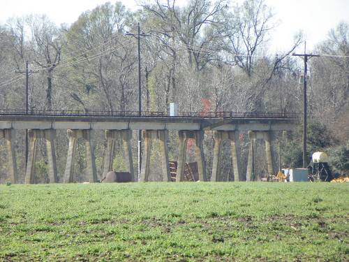
The purpose of the trip was before me. I needed a picture
of a train on this structure I refer to as Stonehenge. It is
the elevated rail bridge which, in sections, carries the rail-
road from the guide levee near Ravenwood Church to the
Melville bridge. Trains leave or enter Livonia from here.
I was hoping to find one to chase coming out of the yard.
I would have lost in Fordoche or in that gravel.

I spent an hour here, 2 trucks passed, neither slowed down.


I even made a movie. I called it Stonehenge and sold it to
Netflix telling them it was a National Heritage movie.


Down on the west end was where old, old La.10 had gone.
That's the road going beneath the bridge.

This is the east end of this portion of elevated rail. There
are others.


I lost my patience and moved on toward the river levee
where the ferry once was.

This bridge is always a gamble. It holds water. It boggles
the mind. One day, one day....

I was getting to higher ground.
Look, there's another one of those "National Heritage" signs.
What a waste of money. Who is going to read it, those two
guys that passed me? Ah, stimulus money at 250 bucks a pop,
if that cheap.

These signs will be gone soon. (LA 10)

Around the corner is another one in case you got lost.

These are to get you back since you can't go any further because the
ferry is gone. Now those are useful. You could get confused
and go straight which would put you in Legionaire on La.1 where
you could go out on the Torras Peninsula. Ever been?

Remnants of the old trestle approach to the Melville
bridge are still there. Look, they are the stumps under the
bridge.

I went down to the old ferry landing. There's the LA 10 sign.

I took the required shots before heading home down the
levee "road" to Krotz Springs.

I shot across the river into Melville.

I have no idea what these guys were doing, maybe enjoying
the bridge?

They left.

I shot the bridge again. That makes 245,678 pictures that I have
of this bridge.

I even did a mirror shot.

Then there was this noise. I knew what it was. When a train
crosses Stonehenge it sounds like all hell is breaking loose.
I was riding out because I'd lost my patience again. I missed
my hard fought to be there shot of Stonehenge and almost
missed the train crossing the bridge. These pictures don't make
the cut.


All got quiet again. And ......

I had 20 miles of this waiting for me.

Them, too.


Dang cows sure do mess up a perfectly good road.


Snake and moose tracks.

I've done a lot of trail riding. You learn that some brown water
is bottomless. I lost a bike in a 4 foot hole which looked
just like this. This road was sand and mud with a little gravel.
What happens is this. The sand dries on top and gives the
road a dry look, but it isn't. Beneath is the wet sand and mud.
I refer to them as "floating roads". They can mess you up
if you don't have the patience to slow down and take it easy.

Was I ever glad to see US 190 again. (at East Krotz Springs)

I took newly paved 103 back to Leonville. Of course a stop
by the Porte Barre yard was in order.

The blue renter engine was in the back working cars. I have
no idea what ultimate direction he was going in. I hadn't the
patience to wait and see. That 20 miles of bad road had me limp.

I know, pretty funky bike, but I don't have the ...... to fool with it.
More later......
